

Ventura County, California
Encyclopedia
Ventura County is a county
in the southern part
of the U.S. state
of California
. It is located on California's Pacific
coast. It is often referred to as the Gold Coast, and has a reputation of being one of the safest populated places and one of the most affluent places in the country. It is ranked as one of the 100 highest-income counties
in the country and as the sixth wealthiest county in California
by per capita income. This is partly because it is part of the Tech Coast Area, and has a large presence in technology corporations like telecommunications, healthcare, development, and especially biotech corporations, most of which are located in the Conejo Valley
. As of December 2008, the median home price
was $355,000.
As of the 2010 census, the county had a population of 823,318. The county seat
is the city
of Ventura
(formally known as San Buenaventura). Ventura County's largest city is Oxnard
, with a population of about 200,000.
, the area was home to the Chumash tribe of Native Americans
.
anchored in an inlet near Point Mugu; its members were the first Europeans to arrive in the area that would become Ventura County.
Active occupation of California by Spain began in 1769. Gaspar de Portolà
led a military expedition by land from San Diego
to Monterey
, passing through Ventura County in August of that year. A priest with the expedition, Father Juan Crespi
, kept a journal of the trip and noted that the area was ideal for a mission to be established and it was a "good site to which nothing is lacking". Also on this expedition was Father Junípero Serra
, who later founded a mission on this site.
On March 31, 1782, the Mission San Buenaventura
was founded by Father Serra. It is named after Saint Bonaventure one of the early intellectual founders of the Franciscan Order. The town that grew up around the mission, originally and still officially named San Buenaventura, has been known as Ventura
since 1891.
In the 1790s, the Spanish Governor of California began granting land concessions to Spanish Californians, often retiring soldiers. These concessions were known as ranchos
and consisted of thousands of acres of land that were used primarily as ranch land for livestock. In Ventura County, Rancho Simi
was granted in 1795 and Rancho El Conejo
in 1802.
and the Governor of California, the Junta, the military in Monterey and the priests and neophytes at Mission San Buenaventura swore allegiance to Mexico on April 11, 1822. California land that had been vested in the King of Spain was now owned by the nation of Mexico.
By the 1830s, Mission San Buenaventura was in a decline with fewer neophytes joining the mission. The number of cattle owned by the mission dropped from first to fifteenth ranking in the California Missions. The missions were secularized by the Mexican government in 1834. The Mexican governors began granting land rights to Mexican Californians, often retiring soldiers. By 1846, there were 19 rancho grants in Ventura County. In 1836, Mission San Buenaventura was transferred from the Church to a secular administrator. The natives who had been working at the mission gradually left to work on the ranchos. By 1839, only 300 Indians were left at the Mission and it slipped into neglect.
Several outhouses were discovered in July 2007 dating back to the 1800s. They have proved to be a treasure trove for archaeologists who braved the lingering smell in the dirt to uncover some 19th-century artifacts.
 The Mexican–American War
began in 1846 but its effect was not felt in Ventura County until 1847. In January of that year, Captain John C. Frémont
led the California Battalion into San Buenaventura finding that the Europeans had fled leaving only the Indians in the Mission. Fremont and the Battalion continued south to sign the Treaty of Cahuenga
with General Andrés Pico
. The Treaty of Guadalupe Hidalgo
formally transferred California to the United States in 1848.
By 1849, a constitution had been adopted for the California territory. The new Legislature met and divided the pending state into 27 counties. At the time, the area that would become Ventura County was the southern part of Santa Barbara County
.
The 1860s brought many changes to the area. A drought caused many of the ranchos to experience financial difficulties and most were divided, sub-divided and sold. Large sections of land were bought by eastern capitalists based on favorable reports of petroleum deposits. A United States Post Office was opened at Mission San Buenaventura in 1861. On April 1, 1866, the town of San Buenaventura was incorporated becoming the first officially recognized town in Ventura County.
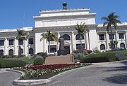
On January 1, 1873, Ventura County was officially split from Santa Barbara County, bringing a flurry of change. That same year, a courthouse and wharf were built in San Buenaventura. A bank was opened and the first public library was created. The school system grew, with the first high school opening in 1890.
Other towns were starting in the county. A plan for Port Hueneme
was recorded in 1874, and Santa Paula
's plan was recorded in 1875. The community of Nordhoff (later renamed Ojai
) was started in 1874. Piru
, Fillmore
and Montalvo were established in 1887. 1892 saw Simi
(later Simi Valley), Somis
, Saticoy
and Moorpark
. Oxnard
was a late-comer, not being established until 1898.
The Southern Pacific Railroad
laid tracks through San Buenaventura in 1887. For convenience in printing their timetables, Southern Pacific shortened San Buenaventura to Ventura. The Post Office soon followed suit. While the city remains officially known as San Buenaventura, it is more commonly referred to as Ventura.
Oil has been known in Ventura County since before the arrival of the Europeans, as the native Chumash people used tar from natural seeps as a sealant and waterproofing for baskets and canoes. In the 1860s, several attempts were made to harvest the petroleum products under Ventura County but none were financially successful, and the oil speculators eventually changed from oil to land development. In 1913, oil exploration began in earnest, with Ralph Lloyd obtaining the financial support of veteran oil man Joseph B. Dabney. Their first well, named "Lloyd No. 1", was started on January 20, 1914. The well struck oil at 2558 feet (780 m) but was destroyed when it went wild. Other wells met a similar fate, until 1916, when a deal was struck with the Shell Oil Company
. 1916 was the year the large South Mountain Oil Field
was discovered, and other deals followed with General Petroleum in 1917 and Associated Oil Company in 1920. At its peak, the largest oil field in the county, the Ventura Avenue oilfield
, discovered in 1919 in the hills north of Ventura, was producing 90000 barrels (14,308,856.6 l) of oil a day, with annual production of over a million and a half barrels. More oil fields came on-line in the 1920s and 1930s, with the Rincon field
, the second-largest, in 1927, and the adjacent San Miguelito
in 1931.
In the early hours of the morning of March 13, 1928, the St. Francis Dam
collapsed, sending billions of gallons of water rushing through the Santa Clarita Valley, killing 385 people, destroying 1,240 homes and flooding 7,900 acres (32 km²) of land, devastating farm fields and orchards. This was the largest single disaster to strike Ventura County.
 Ventura County can be separated into two major parts, East County and West County. East County consists of all cities east of the Conejo Grade, known locally as "The Grade." Geographically East County is the end of the Santa Monica Mountains
, in which the Conejo Valley
is located, and where there is a considerable increase in elevation. Communities which are considered to be in the East County are Thousand Oaks, Newbury Park
, Lake Sherwood
, Hidden Valley
, Santa Rosa Valley, Oak Park
, Moorpark, and Simi Valley
. A majority of these communities are in the Conejo Valley.
West County, which is everything west of the Conejo Grade, consists of communities such as Camarillo, Oxnard, Somis, Point Mugu, Port Hueneme, Ventura
, Ojai, Santa Paula, and Fillmore
. West County consists of some of the first developed cities in the county. The largest beach communities are located in West County on the coastline of the Channel Islands
Harbor.
Starting in the mid-1900s, there was a large growth in population in the East County, moving from the San Fernando Valley
in Los Angeles
and out into the Conejo and Simi Valleys, which consists of Calabasas, Hidden Hills
, Agoura Hills, Agoura, and parts of Westlake Village belonging to Los Angeles County
. The other half of the Conejo Valley, which belongs to Ventura County, consists of Lake Sherwood, Hidden Valley, Oak Park, parts of Westlake Village, Thousand Oaks, and Newbury Park, which was formerly an unincorporated area that is now the most westerly part of Thousand Oaks. Many working-class white people migrated to this area during the 1960s and 1970s out of East and Central Los Angeles. As a result, there was a large growth in population into the Conejo Valley and into Ventura County through the US 101 corridor. Making the US 101 a full freeway in the 1960s, and the expansions that followed, helped make commuting to Los Angeles easier and opened the way for development westward. The communities that have seen the most substantial development are Calabasas, Hidden Hills, Agoura Hills, Westlake Village, Thousand Oaks, and Newbury Park.
Development moved farther down the US 101 corridor and sent population rising in West County cities as well. The largest population growth there has been in Camarillo, Oxnard, and Ventura. Development in the East County and along the US 101 corridor is becoming rare today, because most of these cities were master-planned cities, such as Thousand Oaks and Simi Valley, and are approaching build-out. Although the area still has plenty of open space and land, almost all of it was put aside and mandated never to be developed as part of the master plan of each city. Because of this, its private low-key location, its country feel, and its close proximity to Los Angeles, the Conejo Valley area has become a very attractive place to live. It once had relatively inexpensive real estate, but prices have risen sharply. For example, real estate in Newbury Park has increased in price by over 250% in the last 10 years. Median home prices in the Conejo Valley now range from $700,000 to $2.2 million. The Conejo Valley area is one of the most affluent areas in the United States.
of Channel Islands National Park
and San Nicolas Island
are located in the county. Begg Rock
, 8 miles (12.9 km) north west of the western tip of San Nicolas Island, has claimed one boat.
Most of the population of Ventura County lives in the southern (mainland) portion of the county. The major population centers are the Oxnard Plain
and the Simi
and Conejo
Valleys. In local media, the county is usually split between the eastern portion, generally associated with the San Fernando Valley
, and the western portion, often referred to as "Oxnard-Ventura."
North of Highway 126 the county is mountainous and mostly uninhabited, and contains some of the most unspoiled, rugged and inaccessible wilderness remaining in southern California. Most of this land is in the Los Padres National Forest
, and includes the Chumash Wilderness
in the northernmost portion, adjacent to Kern County, as well as the large Sespe Wilderness and portions of both the Dick Smith Wilderness
and Matilija Wilderness (both of these protected areas straddle the line with Santa Barbara County). All of the wilderness areas are within the jurisdiction of Los Padres National Forest.
The highest peaks in the county include Mount Pinos
(8831', 2697 m), Frazier Mountain
(8017', 2444 m), and Reyes Peak (7525', 2294 m), all except Reyes Peak in the San Emigdio Mountains
(Pinos and Frazier Mountain are sometimes assigned to the Tehachapis
). The uplands are well-timbered with coniferous forests, and receive plentiful snow in the winter.
Mount Pinos is sacred to the Chumash Indians. It is known to them as Iwihinmu, and was considered to be the center of the universe; being the highest peak in the vicinity, it has a spectacular view, unimpeded in three directions.
The Santa Clara River
is the principal waterway. Lake Casitas
, an artificial reservoir, is the largest body of water.
Census-designated place
Other unincorporated communities
Unconstructed
and Metrolink
trains, as well as Greyhound Lines
,
Gold Coast Transit
(formerly South Coast Area Transit), and VISTA
buses. The cities of Camarillo
, Simi Valley
and Thousand Oaks
have their own small bus systems.
Island Packers ferries connect Ventura with the five islands of Channel Islands National Park
.
- 14 locations, Oxnard Public Library, Thousand Oaks Library, Moorpark City Library, and Blanchard Community Library (in Santa Paula).
Academic Libraries: California State University Channel Islands, California Lutheran University
, St. Thomas Aquinas College, Moorpark College
, Oxnard College
, and Ventura College
.
Other: Ronald Reagan Presidential Library
, Ventura County Law Library.
Unlike most other areas of Coastal California
, Ventura County tends to support the Republican Party in local and national elections. While Republicans used to win a large majority of votes throughout the 1970s and 1980s, no party has received more than 55% of the county's vote since 1992. Prior to Barack Obama
's victory in the county in 2008
, the last Democrat to win a majority was Lyndon Johnson
in 1964
, though Democrat Bill Clinton carried the county by a plurality in 1992
and 1996
.
Most of the county's area, including inland areas and the cities of Thousand Oaks
and Moorpark
, lies in the 24th district
, which has a PVI of R +5 (meaning that based on the presidential election results of 2000 and 2004, the district is 5% more Republican than the nation) and is represented by Republican Elton Gallegly
. Coastal regions of Ventura County along with the cities of Oxnard
and Ventura
, the 23rd district
, which includes has a Cook Partisan Index (CPI) rating of D +9 and is currently represented by Democrat Lois Capps. In the State Senate
, Ventura is part of the 17th, 19th, and 23rd Senate districts, which are held by Republicans Sharon Runner and Tony Strickland
and Democrat Fran Pavley
, respectively. In the State Assembly
, Ventura is in the 35th, 37th, 38th, and 41st districts. The 35th and 41st districts are held by Democrats Das Williams
and Julia Brownley
, respectively; the 37th and 38th districts are held by Republicans Jeff Gorell
and Cameron Smyth
, respectively.
Current county supervisor
s are Steve Bennett, Linda Parks, Kathy Long, Peter Foy, and John C. Zaragoza. Geoff Dean is the sheriff of the Ventura County Sheriff's Department. Bob Roper is the chief of the Ventura County Fire Department
.
Republicans have historically held the registration advantage, but on March 3, 2008, Democratic registration surpassed Republican registration. The cities of Camarillo, Moorpark, Simi Valley, and Thousand Oaks all have voter rolls with Republican pluralities. The remaining cities and towns in the county have a Democratic plurality or majority on the voter rolls, while the unincorporated areas are split almost evenly between the parties.
, and 36,941 (4.5%) from two or more races. Hispanic or Latino of any race were 331,567 persons (40.3%).
of 2000, there were 753,197 people, 243,234 households, and 182,911 families living in the county. The population density
was 408 people per square mile (158/km²). There were 251,712 housing units at an average density of 136 per square mile (53/km²). The racial makeup of the county was 69.93% White
, 5.35% Asian
, 1.95% Black
or African American
, 0.94% Native American
, 0.22% Pacific Islander
, 17.68% from other races
, and 3.93% from two or more races. About one third (33.42%) of the population is Hispanic
or Latino
of any race. 9.8% were of German, 7.7% English
and 7.1% Irish
ancestry according to Census 2000. 67.1% spoke English
, 26.2% Spanish
and 1.5% Tagalog
as their first language.
There were 243,234 households, of which 39.7% had children under the age of 18 living with them, 59.5% were married couples
living together, 10.9% had a female householder with no husband present, and 24.8% were non-families. 18.9% of all households were made up of individuals, and 7.4% had someone living alone who was 65 years of age or older. The average household size was 3.04 and the average family size was 3.46.
In the county the population was spread out, with 28.4% under the age of 18, 9.0% from 18 to 24, 30.7% from 25 to 44, 21.7% from 45 to 64, and 10.2% who were 65 or older. The median age was 34 years. For every 100 females there were 99.7 males. For every 100 females age 18 and over, there were 97.5 males.
The median income for a household in the county was $59,666, and the median income for a family was $65,285. Males had a median income of $45,310, versus $32,216 for females. The per capita income
for the county was $24,600. About 6.4% of families and 9.2% of the population were below the poverty line, including 11.6% of those under age 18 and 6.3% of those aged 65 or over.
According to an updated 2005 US Census, median
household income was $66,859, while the mean was $85,032. Per capita income
was up to $29,634, making it the 6th wealthiest county in California.
is so called due to its use as the location for Sherwood Forest in the 1922 film, Robin Hood
, starring Douglas Fairbanks. The 1938 film, The Adventures of Robin Hood
, starring Errol Flynn, also had a major scene shot on location at "Sherwood Forest".
On July 23, 1982 actor Vic Morrow
and two children actors (My-Ca Dinh Le and Renee Shin-Ye Chen) were filming a helicopter scene for Twilight Zone: The Movie
in the area of Indian Dunes in Ventura County when the helicopter lost control and crashed on top of them. Morrow and Le were decapitated and Chen was fatally crushed.
In 2009, the popular VH1 television show Tool Academy was filmed in Ventura County. In 1963, the touching Korean War
story The Young and The Brave
, featuring a brave and resourceful young boy, was filmed in rural areas of Ventura County.
Also, in 2000 the movie Swordfish filmed the final bank scene on East Main Street in Ventura. The building they used is the white building on the corner.34.280823°N 119.294599°W
The movie Back to the Future Part III
filmed the scene where Marty returns to the year 1985 in the time-traveling DeLorean at the railroad crossing at S Ventura Rd & Shoreview Dr in Port Hueneme
Many films including Swordfish
, Little Miss Sunshine
, Chinatown, Erin Brockovich
, The Aviator, and The Rock
were partly filmed in Ventura.
Downtown Ventura also hosts the Majestic Ventura Theater, a beautiful early century theatre, which is situated about two blocks away from city hall. It serves as a venue for concerts. The theater has seen many bands such as Gregg Allman
, John Prine
, The Doors
, Devo
, Van Halen
, X, Paramore
, She Wants Revenge
, Pennywise
, Red Hot Chili Peppers
, Lamb of God
, Social Distortion
, Bad Religion
, Thrice
, Avenged Sevenfold
, Fugazi, Incubus
, Tom Petty
, America
, They Might Be Giants
, and Modest Mouse
, as well as successful local artists such as Army of Freshmen
, Big Bad Voodoo Daddy
, Gregory Hillman, Bruce Kimmell
, Shim Come Quick
County (United States)
In the United States, a county is a geographic subdivision of a state , usually assigned some governmental authority. The term "county" is used in 48 of the 50 states; Louisiana is divided into parishes and Alaska into boroughs. Parishes and boroughs are called "county-equivalents" by the U.S...
in the southern part
Southern California
Southern California is a megaregion, or megapolitan area, in the southern area of the U.S. state of California. Large urban areas include Greater Los Angeles and Greater San Diego. The urban area stretches along the coast from Ventura through the Southland and Inland Empire to San Diego...
of the U.S. state
U.S. state
A U.S. state is any one of the 50 federated states of the United States of America that share sovereignty with the federal government. Because of this shared sovereignty, an American is a citizen both of the federal entity and of his or her state of domicile. Four states use the official title of...
of California
California
California is a state located on the West Coast of the United States. It is by far the most populous U.S. state, and the third-largest by land area...
. It is located on California's Pacific
Pacific Ocean
The Pacific Ocean is the largest of the Earth's oceanic divisions. It extends from the Arctic in the north to the Southern Ocean in the south, bounded by Asia and Australia in the west, and the Americas in the east.At 165.2 million square kilometres in area, this largest division of the World...
coast. It is often referred to as the Gold Coast, and has a reputation of being one of the safest populated places and one of the most affluent places in the country. It is ranked as one of the 100 highest-income counties
Highest-income counties in the United States
There are 3,141 counties in the United States. The source of the data is the U.S. Census Bureau and the data is current as of the indicated year. Independent cities are considered county-equivalent by the Census Bureau.-2011:...
in the country and as the sixth wealthiest county in California
California locations by per capita income
All figures as of the census of 2000 by the United States Census Bureau.California is the thirteenth-richest state in the United States of America, with a per capita income of $22,711 .-California counties ranked by per capita income:...
by per capita income. This is partly because it is part of the Tech Coast Area, and has a large presence in technology corporations like telecommunications, healthcare, development, and especially biotech corporations, most of which are located in the Conejo Valley
Conejo Valley
The Conejo Valley is a region spanning both southeastern Ventura County and northwestern Los Angeles County in Southern California, United States...
. As of December 2008, the median home price
Real estate pricing
Real estate pricing deals with the valuation of real estate and all the standard methods of determining the price of fixed assets apply....
was $355,000.
As of the 2010 census, the county had a population of 823,318. The county seat
County seat
A county seat is an administrative center, or seat of government, for a county or civil parish. The term is primarily used in the United States....
is the city
City
A city is a relatively large and permanent settlement. Although there is no agreement on how a city is distinguished from a town within general English language meanings, many cities have a particular administrative, legal, or historical status based on local law.For example, in the U.S...
of Ventura
Ventura, California
Ventura is the county seat of Ventura County, California, United States, incorporated in 1866. The population was 106,433 at the 2010 census, up from 100,916 at the 2000 census. Ventura is accessible via U.S...
(formally known as San Buenaventura). Ventura County's largest city is Oxnard
Oxnard, California
Oxnard is the 113th largest city in the United States, 19th largest city in California and largest city in Ventura County, California, by way of population. It is located at the western edge of the fertile Oxnard Plain, and is an important agricultural center, with its distinction as the...
, with a population of about 200,000.
History
Prior to the arrival of Europeans in CaliforniaCalifornia
California is a state located on the West Coast of the United States. It is by far the most populous U.S. state, and the third-largest by land area...
, the area was home to the Chumash tribe of Native Americans
Native Americans in the United States
Native Americans in the United States are the indigenous peoples in North America within the boundaries of the present-day continental United States, parts of Alaska, and the island state of Hawaii. They are composed of numerous, distinct tribes, states, and ethnic groups, many of which survive as...
.
Spanish period
In October 1542, the expedition led by Juan Rodríguez CabrilloJuan Rodríguez Cabrillo
Juan Rodriguez Cabrillo was a Portuguese explorer noted for his exploration of the west coast of North America on behalf of Spain. Cabrillo was the first European explorer to navigate the coast of present day California in the United States...
anchored in an inlet near Point Mugu; its members were the first Europeans to arrive in the area that would become Ventura County.
Active occupation of California by Spain began in 1769. Gaspar de Portolà
Gaspar de Portolà
Gaspar de Portolà i Rovira was a soldier, governor of Baja and Alta California , explorer and founder of San Diego and Monterey. He was born in Os de Balaguer, province of Lleida, in Catalonia, Spain, of Catalan nobility. Don Gaspar served as a soldier in the Spanish army in Italy and Portugal...
led a military expedition by land from San Diego
San Diego, California
San Diego is the eighth-largest city in the United States and second-largest city in California. The city is located on the coast of the Pacific Ocean in Southern California, immediately adjacent to the Mexican border. The birthplace of California, San Diego is known for its mild year-round...
to Monterey
Monterey, California
The City of Monterey in Monterey County is located on Monterey Bay along the Pacific coast in Central California. Monterey lies at an elevation of 26 feet above sea level. As of the 2010 census, the city population was 27,810. Monterey is of historical importance because it was the capital of...
, passing through Ventura County in August of that year. A priest with the expedition, Father Juan Crespi
Juan Crespi
Father Juan Crespí was a Majorcan missionary and explorer of Las Californias. He entered the Franciscan order at the age of seventeen. He came to America in 1749, and accompanied explorers Francisco Palóu and Junípero Serra. In 1767 he went to the Baja Peninsula and was placed in charge of the...
, kept a journal of the trip and noted that the area was ideal for a mission to be established and it was a "good site to which nothing is lacking". Also on this expedition was Father Junípero Serra
Junípero Serra
Blessed Junípero Serra, O.F.M., , known as Fra Juníper Serra in Catalan, his mother tongue was a Majorcan Franciscan friar who founded the mission chain in Alta California of the Las Californias Province in New Spain—present day California, United States. Fr...
, who later founded a mission on this site.
On March 31, 1782, the Mission San Buenaventura
Mission San Buenaventura
Mission San Buenaventura was founded on Easter Sunday, March 31, 1782 in Las Californias, part of the Spanish Viceroyalty of New Spain. Named for a Franciscan theologian, Saint Bonaventure, it was the last of the missions founded by Father Serra...
was founded by Father Serra. It is named after Saint Bonaventure one of the early intellectual founders of the Franciscan Order. The town that grew up around the mission, originally and still officially named San Buenaventura, has been known as Ventura
Ventura, California
Ventura is the county seat of Ventura County, California, United States, incorporated in 1866. The population was 106,433 at the 2010 census, up from 100,916 at the 2000 census. Ventura is accessible via U.S...
since 1891.
In the 1790s, the Spanish Governor of California began granting land concessions to Spanish Californians, often retiring soldiers. These concessions were known as ranchos
Ranchos of California
The Spanish, and later the Méxican government encouraged settlement of territory now known as California by the establishment of large land grants called ranchos, from which the English ranch is derived. Devoted to raising cattle and sheep, the owners of the ranchos attempted to pattern themselves...
and consisted of thousands of acres of land that were used primarily as ranch land for livestock. In Ventura County, Rancho Simi
Rancho Simi
Rancho Simi, also known as Rancho San José de Nuestra Senora de Altagarcia y Simi, was a Spanish land grant in eastern Ventura and western Los Angeles counties given in 1795 to Francisco Javier Pico and his two brothers, Patricio Pico and Miguel Pico by Governor Diego de Borica...
was granted in 1795 and Rancho El Conejo
Rancho El Conejo
Rancho El Conejo was a Spanish land grant in California given in 1803 to Jose Polanco and Ygnacio Rodriguez that encompassed the area now known as the Conejo Valley in southeastern Ventura and northwestern Los Angeles Counties. El Conejo means "The Rabbit" in Spanish, and refers to the many...
in 1802.
Mexican period
In 1822, California was notified of Mexico's independence from SpainMexican War of Independence
The Mexican War of Independence was an armed conflict between the people of Mexico and the Spanish colonial authorities which started on 16 September 1810. The movement, which became known as the Mexican War of Independence, was led by Mexican-born Spaniards, Mestizos and Amerindians who sought...
and the Governor of California, the Junta, the military in Monterey and the priests and neophytes at Mission San Buenaventura swore allegiance to Mexico on April 11, 1822. California land that had been vested in the King of Spain was now owned by the nation of Mexico.
By the 1830s, Mission San Buenaventura was in a decline with fewer neophytes joining the mission. The number of cattle owned by the mission dropped from first to fifteenth ranking in the California Missions. The missions were secularized by the Mexican government in 1834. The Mexican governors began granting land rights to Mexican Californians, often retiring soldiers. By 1846, there were 19 rancho grants in Ventura County. In 1836, Mission San Buenaventura was transferred from the Church to a secular administrator. The natives who had been working at the mission gradually left to work on the ranchos. By 1839, only 300 Indians were left at the Mission and it slipped into neglect.
Several outhouses were discovered in July 2007 dating back to the 1800s. They have proved to be a treasure trove for archaeologists who braved the lingering smell in the dirt to uncover some 19th-century artifacts.
American period
Mexican–American War
The Mexican–American War, also known as the First American Intervention, the Mexican War, or the U.S.–Mexican War, was an armed conflict between the United States and Mexico from 1846 to 1848 in the wake of the 1845 U.S...
began in 1846 but its effect was not felt in Ventura County until 1847. In January of that year, Captain John C. Frémont
John C. Frémont
John Charles Frémont , was an American military officer, explorer, and the first candidate of the anti-slavery Republican Party for the office of President of the United States. During the 1840s, that era's penny press accorded Frémont the sobriquet The Pathfinder...
led the California Battalion into San Buenaventura finding that the Europeans had fled leaving only the Indians in the Mission. Fremont and the Battalion continued south to sign the Treaty of Cahuenga
Treaty of Cahuenga
The Treaty of Cahuenga, also called the "Capitulation of Cahuenga," ended the fighting of the Mexican-American War in Alta California in 1847. It was not a formal treaty between nations but an informal agreement between rival military forces in which the Californios gave up fighting...
with General Andrés Pico
Andrés Pico
Andrés Pico was a Californio who became a successful rancher, served as a military commander during the Mexican-American War; and was elected to the state assembly and senate after California became a state, when he was also commissioned as a brigadier general in the state militia.-Early...
. The Treaty of Guadalupe Hidalgo
Treaty of Guadalupe Hidalgo
The Treaty of Guadalupe Hidalgo is the peace treaty, largely dictated by the United States to the interim government of a militarily occupied Mexico City, that ended the Mexican-American War on February 2, 1848...
formally transferred California to the United States in 1848.
By 1849, a constitution had been adopted for the California territory. The new Legislature met and divided the pending state into 27 counties. At the time, the area that would become Ventura County was the southern part of Santa Barbara County
Santa Barbara County, California
Santa Barbara County is a county located in the southern portion of the U.S. state of California, on the Pacific coast. As of 2010 the county had a population of 423,895. The county seat is Santa Barbara and the largest city is Santa Maria.-History:...
.
The 1860s brought many changes to the area. A drought caused many of the ranchos to experience financial difficulties and most were divided, sub-divided and sold. Large sections of land were bought by eastern capitalists based on favorable reports of petroleum deposits. A United States Post Office was opened at Mission San Buenaventura in 1861. On April 1, 1866, the town of San Buenaventura was incorporated becoming the first officially recognized town in Ventura County.
On January 1, 1873, Ventura County was officially split from Santa Barbara County, bringing a flurry of change. That same year, a courthouse and wharf were built in San Buenaventura. A bank was opened and the first public library was created. The school system grew, with the first high school opening in 1890.
Other towns were starting in the county. A plan for Port Hueneme
Port Hueneme, California
Port Hueneme is a small beach city in Ventura County, California surrounded by the city of Oxnard and the Pacific Ocean. The name derives from the Spanish spelling of the Chumash wene me, meaning "Resting Place". The area was discovered by Juan Rodríguez Cabrillo in the mid 16th century...
was recorded in 1874, and Santa Paula
Santa Paula, California
Santa Paula is a city within Ventura County, California, United States. The population was 29,321 at the 2010 census, up from 28,598 at the 2000 census...
's plan was recorded in 1875. The community of Nordhoff (later renamed Ojai
Ojai, California
Ojai is a city in Ventura County, California, USA. It is situated in the Ojai Valley , surrounded by hills and mountains. The population was 7,461 at the 2010 census, down from 7,862 at the 2000 census.-History:Chumash Indians were the early inhabitants of the valley...
) was started in 1874. Piru
Piru, California
Piru is a small unincorporated census-designated town located in eastern Ventura County, California, in the Santa Clara River Valley near the Santa Clara River and Highway 126, about seven miles east of Fillmore and about west of Interstate 5. The population was 2,063 at the 2010 census, up from...
, Fillmore
Fillmore, California
Fillmore is a city in Ventura County, California, United States. The population was 15,002 at the 2010 census, up from 13,643 at the 2000 census.- History :...
and Montalvo were established in 1887. 1892 saw Simi
Simi Valley, California
-2010:The 2010 United States Census reported that Simi Valley had a population of 124,237. The population density was 2,940.8 people per square mile...
(later Simi Valley), Somis
Somis, California
Somis is an unincorporated area of Ventura County, California, just north of the Camarillo city limits. Its generally recognized boundaries are the areas around the intersection of Somis Road and Los Angeles Avenue , the latter being the dividing line between uptown and downtown. Its official...
, Saticoy
Saticoy, California
Saticoy is an unincorporated town and census-designated place in Ventura County, California. It lies in the Santa Clara River Valley, south of the intersection of Wells Road and the Santa Paula Freeway, on the east side of Ventura, and north of the Santa Clara River at the head of the delta...
and Moorpark
Moorpark, California
Moorpark is a city in Southern California. It was founded in 1900 by Robert Poindexter, presumably named after the moorpark apricots that grew in the area. The city has experienced a great amount of growth since the late 1970s...
. Oxnard
Oxnard, California
Oxnard is the 113th largest city in the United States, 19th largest city in California and largest city in Ventura County, California, by way of population. It is located at the western edge of the fertile Oxnard Plain, and is an important agricultural center, with its distinction as the...
was a late-comer, not being established until 1898.
The Southern Pacific Railroad
Southern Pacific Railroad
The Southern Pacific Transportation Company , earlier Southern Pacific Railroad and Southern Pacific Company, and usually simply called the Southern Pacific or Espee, was an American railroad....
laid tracks through San Buenaventura in 1887. For convenience in printing their timetables, Southern Pacific shortened San Buenaventura to Ventura. The Post Office soon followed suit. While the city remains officially known as San Buenaventura, it is more commonly referred to as Ventura.
Oil has been known in Ventura County since before the arrival of the Europeans, as the native Chumash people used tar from natural seeps as a sealant and waterproofing for baskets and canoes. In the 1860s, several attempts were made to harvest the petroleum products under Ventura County but none were financially successful, and the oil speculators eventually changed from oil to land development. In 1913, oil exploration began in earnest, with Ralph Lloyd obtaining the financial support of veteran oil man Joseph B. Dabney. Their first well, named "Lloyd No. 1", was started on January 20, 1914. The well struck oil at 2558 feet (780 m) but was destroyed when it went wild. Other wells met a similar fate, until 1916, when a deal was struck with the Shell Oil Company
Shell Oil Company
Shell Oil Company is the United States-based subsidiary of Royal Dutch Shell, a multinational oil company of Anglo Dutch origins, which is amongst the largest oil companies in the world. Approximately 22,000 Shell employees are based in the U.S. The head office in the U.S. is in Houston, Texas...
. 1916 was the year the large South Mountain Oil Field
South Mountain Oil Field
The South Mountain Oil Field is a large and productive oil field in Ventura County, California, in the United States, in and adjacent to the city of Santa Paula. Discovered in 1916, and having a cumulative production of over of oil, it is the 37th largest oil field in California and the second...
was discovered, and other deals followed with General Petroleum in 1917 and Associated Oil Company in 1920. At its peak, the largest oil field in the county, the Ventura Avenue oilfield
Ventura Oil Field
The Ventura Oil Field is a large and currently productive oil field in the hills immediately north of the city of Ventura in southern California in the United States. It is bisected by California State Route 33, the freeway connecting Ventura to Ojai, and is about eight miles long by two across,...
, discovered in 1919 in the hills north of Ventura, was producing 90000 barrels (14,308,856.6 l) of oil a day, with annual production of over a million and a half barrels. More oil fields came on-line in the 1920s and 1930s, with the Rincon field
Rincon Oil Field
The Rincon Oil Field is a large oil field on the coast of southern California, about ten miles northwest of the city of Ventura, and about 20 miles east-southeast of the city of Santa Barbara. It is the westernmost onshore field in a series of three fields which follow the Ventura Anticline, an...
, the second-largest, in 1927, and the adjacent San Miguelito
San Miguelito Oil Field
The San Miguelito Oil Field is a large and currently productive oil field in the hills northwest of the city of Ventura in southern California in the United States. The field is close to the coastline, with U.S...
in 1931.
In the early hours of the morning of March 13, 1928, the St. Francis Dam
St. Francis Dam
The St. Francis Dam was a concrete gravity-arch dam, designed to create a reservoir as a storage point of the Los Angeles Aqueduct. It was located 40 miles northwest of Los Angeles, California, near the present city of Santa Clarita....
collapsed, sending billions of gallons of water rushing through the Santa Clarita Valley, killing 385 people, destroying 1,240 homes and flooding 7,900 acres (32 km²) of land, devastating farm fields and orchards. This was the largest single disaster to strike Ventura County.
Modern period
Santa Monica Mountains
The Santa Monica Mountains are a Transverse Range in Southern California, along the coast of the Pacific Ocean in the United States.-Geography:...
, in which the Conejo Valley
Conejo Valley
The Conejo Valley is a region spanning both southeastern Ventura County and northwestern Los Angeles County in Southern California, United States...
is located, and where there is a considerable increase in elevation. Communities which are considered to be in the East County are Thousand Oaks, Newbury Park
Newbury Park, California
The community of Newbury Park, California is located in the western portion of the city of Thousand Oaks and Casa Conejo, an unincorporated area of southeastern Ventura County's Conejo Valley, which is also in the northwestern Greater Los Angeles Area...
, Lake Sherwood
Lake Sherwood
Lake Sherwood may refer to some places in the United States:United States*Lake Sherwood, California, a gated community*Lake Sherwood, Wisconsin, a CDP*Lake Sherwood , a lake*Lake Sherwood , a lake in the Monongahela National Forest...
, Hidden Valley
Hidden Valley
-Places:Australia*Hidden Valley, Northern Territory, A suburb in Darwin**Hidden Valley Raceway, A motorsports complex located near Darwin*Hidden Valley National Park, Western AustraliaCanada*Hidden Valley, Calgary, a neighbourhood in Calgary, Alberta...
, Santa Rosa Valley, Oak Park
Oak Park, California
Oak Park is a census-designated place located in the Simi Hills, in Ventura County, California. As of the 2010 census, Oak Park had a population of 14,266, up from 14,225 at the 2000 census...
, Moorpark, and Simi Valley
Simi Valley
Simi Valley is a synclinal valley in Southern California in the United States. It is an enclosed or hidden valley surrounded by mountains and hills. It is connected to the San Fernando Valley to the east by the Santa Susana Pass & 118 freeway, and in the west the narrows of the Arroyo Simi and 118...
. A majority of these communities are in the Conejo Valley.
West County, which is everything west of the Conejo Grade, consists of communities such as Camarillo, Oxnard, Somis, Point Mugu, Port Hueneme, Ventura
Ventura
-Places:*Ventura, California, US*Ventura, Iowa, US*Ventura County, California, US*Las Venturas, San Andreas, a fictional city in Grand Theft Auto series of video games...
, Ojai, Santa Paula, and Fillmore
Fillmore, California
Fillmore is a city in Ventura County, California, United States. The population was 15,002 at the 2010 census, up from 13,643 at the 2000 census.- History :...
. West County consists of some of the first developed cities in the county. The largest beach communities are located in West County on the coastline of the Channel Islands
Channel Islands of California
The Channel Islands of California are a chain of eight islands located in the Pacific Ocean off the coast of Southern California along the Santa Barbara Channel in the United States of America...
Harbor.
Starting in the mid-1900s, there was a large growth in population in the East County, moving from the San Fernando Valley
San Fernando Valley
The San Fernando Valley is an urbanized valley located in the Los Angeles metropolitan area of southern California, United States, defined by the dramatic mountains of the Transverse Ranges circling it...
in Los Angeles
Los Ángeles
Los Ángeles is the capital of the province of Biobío, in the commune of the same name, in Region VIII , in the center-south of Chile. It is located between the Laja and Biobío rivers. The population is 123,445 inhabitants...
and out into the Conejo and Simi Valleys, which consists of Calabasas, Hidden Hills
Hidden Hills
Hidden Hills is an American sitcom that aired on NBC during the 2002-2003 TV season. Based on the book Surviving Suburbia, the series was created by Peter Segal and Ric Swartzlander. The theme song was Pleasant Valley Sunday by the Monkees.-Cast:...
, Agoura Hills, Agoura, and parts of Westlake Village belonging to Los Angeles County
Los Angeles County, California
Los Angeles County is a county in the U.S. state of California. As of 2010 U.S. Census, the county had a population of 9,818,605, making it the most populous county in the United States. Los Angeles County alone is more populous than 42 individual U.S. states...
. The other half of the Conejo Valley, which belongs to Ventura County, consists of Lake Sherwood, Hidden Valley, Oak Park, parts of Westlake Village, Thousand Oaks, and Newbury Park, which was formerly an unincorporated area that is now the most westerly part of Thousand Oaks. Many working-class white people migrated to this area during the 1960s and 1970s out of East and Central Los Angeles. As a result, there was a large growth in population into the Conejo Valley and into Ventura County through the US 101 corridor. Making the US 101 a full freeway in the 1960s, and the expansions that followed, helped make commuting to Los Angeles easier and opened the way for development westward. The communities that have seen the most substantial development are Calabasas, Hidden Hills, Agoura Hills, Westlake Village, Thousand Oaks, and Newbury Park.
Development moved farther down the US 101 corridor and sent population rising in West County cities as well. The largest population growth there has been in Camarillo, Oxnard, and Ventura. Development in the East County and along the US 101 corridor is becoming rare today, because most of these cities were master-planned cities, such as Thousand Oaks and Simi Valley, and are approaching build-out. Although the area still has plenty of open space and land, almost all of it was put aside and mandated never to be developed as part of the master plan of each city. Because of this, its private low-key location, its country feel, and its close proximity to Los Angeles, the Conejo Valley area has become a very attractive place to live. It once had relatively inexpensive real estate, but prices have risen sharply. For example, real estate in Newbury Park has increased in price by over 250% in the last 10 years. Median home prices in the Conejo Valley now range from $700,000 to $2.2 million. The Conejo Valley area is one of the most affluent areas in the United States.
Geography
According to the 2000 census, the county has a total area of 2208.2 square miles (5,719.2 km²), of which 1845.3 square miles (4,779.3 km²) (or 83.57%) is land and 362.9 square miles (939.9 km²) (or 16.43%) is water. Anacapa IslandAnacapa Island
Anacapa Island is a small volcanic island located about off the coast of Port Hueneme, California, in Ventura County. The Island is composed of a series of narrow islets six miles long, running in a mostly east-west orientation, five miles east of Santa Cruz Island...
of Channel Islands National Park
Channel Islands National Park
- External links :* Official site: * *...
and San Nicolas Island
San Nicolas Island
San Nicolas Island is the most remote of California's Channel Islands. It is part of Ventura County. The 14,562 acre island is currently controlled by the United States Navy and is used as a weapons testing and training facility, served by Naval Outlying Field San Nicolas Island...
are located in the county. Begg Rock
Begg Rock
Begg Rock, high, is northwest of the west point of San Nicolas Island, Ventura County California. This island rises abruptly from depths of . A reef extends north and south of the island over in each direction. A lighted whistle buoy is north of the rock. This rock may be found on NOAA chart...
, 8 miles (12.9 km) north west of the western tip of San Nicolas Island, has claimed one boat.
Most of the population of Ventura County lives in the southern (mainland) portion of the county. The major population centers are the Oxnard Plain
Oxnard Plain
The Oxnard Plain is a large coastal plain in southwest Ventura County, California bounded by the Santa Monica Mountains, the Santa Susana Mountains, and Oak Ridge to the east, the Topatopa Mountains to the north, the Santa Clara River Valley to the northeast and the Pacific Ocean to the south and...
and the Simi
Simi Valley, California
-2010:The 2010 United States Census reported that Simi Valley had a population of 124,237. The population density was 2,940.8 people per square mile...
and Conejo
Conejo Valley
The Conejo Valley is a region spanning both southeastern Ventura County and northwestern Los Angeles County in Southern California, United States...
Valleys. In local media, the county is usually split between the eastern portion, generally associated with the San Fernando Valley
San Fernando Valley
The San Fernando Valley is an urbanized valley located in the Los Angeles metropolitan area of southern California, United States, defined by the dramatic mountains of the Transverse Ranges circling it...
, and the western portion, often referred to as "Oxnard-Ventura."
North of Highway 126 the county is mountainous and mostly uninhabited, and contains some of the most unspoiled, rugged and inaccessible wilderness remaining in southern California. Most of this land is in the Los Padres National Forest
Los Padres National Forest
Los Padres National Forest is a forest located in southern and central California, which includes most of the mountainous land along the California coast from Ventura to Monterey, extending inland...
, and includes the Chumash Wilderness
Chumash Wilderness
The Chumash Wilderness is a wilderness area in the mountains of northern Ventura County and southwestern Kern County in California, USA. It is completely within the Los Padres National Forest, and includes most of the highest terrain in Ventura County...
in the northernmost portion, adjacent to Kern County, as well as the large Sespe Wilderness and portions of both the Dick Smith Wilderness
Dick Smith Wilderness
The Dick Smith Wilderness is a wilderness area in the mountains of eastern Santa Barbara County, California, USA, with a portion in Ventura County. It is completely contained within the Los Padres National Forest, and is northeast of the city of Santa Barbara and north of the city of Ojai...
and Matilija Wilderness (both of these protected areas straddle the line with Santa Barbara County). All of the wilderness areas are within the jurisdiction of Los Padres National Forest.
The highest peaks in the county include Mount Pinos
Mount Pinos
Mount Pinos is a mountain located in the Los Padres National Forest on the boundary between Ventura and Kern counties in California. The summit is the highest point in Ventura County.- Geography :...
(8831', 2697 m), Frazier Mountain
Frazier Mountain
Frazier Mountain is a broad, pine-forested peak in the Transverse Ranges within the Los Padres National Forest, in Ventura County, California. At , Frazier is the fifth-highest mountain in the Transverse Ranges of Southern California....
(8017', 2444 m), and Reyes Peak (7525', 2294 m), all except Reyes Peak in the San Emigdio Mountains
San Emigdio Mountains
The San Emigdio Mountains are a part of the Transverse Ranges in Southern California, extending from Interstate 5 at Lebec and Gorman on the east to Highway 33–166 on the west. They link the Tehachapis and Temblor Range and form the southern wall of the San Joaquin Valley.The range is within Los...
(Pinos and Frazier Mountain are sometimes assigned to the Tehachapis
Tehachapi Mountains
The Tehachapi Mountains , regionally also called The Tehachapis, are a mountain range in the Transverse Ranges system of California in the Western United States...
). The uplands are well-timbered with coniferous forests, and receive plentiful snow in the winter.
Mount Pinos is sacred to the Chumash Indians. It is known to them as Iwihinmu, and was considered to be the center of the universe; being the highest peak in the vicinity, it has a spectacular view, unimpeded in three directions.
The Santa Clara River
Santa Clara River (California)
The Santa Clara River is approximately long, located in southern California in the United States. It drains an area of the coastal mountains north of Los Angeles. The Santa Clara is one of the largest river systems along the coast of Southern California and one of only a few remaining river...
is the principal waterway. Lake Casitas
Lake Casitas
Lake Casitas is an artificial lake in the Los Padres National Forest of Ventura County, California, created by the construction of Casitas Dam on Coyote Creek, two miles before it joins the Ventura River. Santa Ana Creek and North Fork Coyote Creek also flow into the lake. The dam was constructed...
, an artificial reservoir, is the largest body of water.
Cities
Incorporated cities- CamarilloCamarillo, CaliforniaCamarillo is a city in Ventura County, California, United States. The population was 65,201 at the 2010 census, up from 57,084 at the 2000 census. The Ventura Freeway Camarillo is a city in Ventura County, California, United States. The population was 65,201 at the 2010 census, up from 57,084 at...
- FillmoreFillmore, CaliforniaFillmore is a city in Ventura County, California, United States. The population was 15,002 at the 2010 census, up from 13,643 at the 2000 census.- History :...
- MoorparkMoorpark, CaliforniaMoorpark is a city in Southern California. It was founded in 1900 by Robert Poindexter, presumably named after the moorpark apricots that grew in the area. The city has experienced a great amount of growth since the late 1970s...
- OjaiOjai, CaliforniaOjai is a city in Ventura County, California, USA. It is situated in the Ojai Valley , surrounded by hills and mountains. The population was 7,461 at the 2010 census, down from 7,862 at the 2000 census.-History:Chumash Indians were the early inhabitants of the valley...
- OxnardOxnard, CaliforniaOxnard is the 113th largest city in the United States, 19th largest city in California and largest city in Ventura County, California, by way of population. It is located at the western edge of the fertile Oxnard Plain, and is an important agricultural center, with its distinction as the...
- Port HuenemePort Hueneme, CaliforniaPort Hueneme is a small beach city in Ventura County, California surrounded by the city of Oxnard and the Pacific Ocean. The name derives from the Spanish spelling of the Chumash wene me, meaning "Resting Place". The area was discovered by Juan Rodríguez Cabrillo in the mid 16th century...
- Santa PaulaSanta Paula, CaliforniaSanta Paula is a city within Ventura County, California, United States. The population was 29,321 at the 2010 census, up from 28,598 at the 2000 census...
- Simi ValleySimi Valley, California-2010:The 2010 United States Census reported that Simi Valley had a population of 124,237. The population density was 2,940.8 people per square mile...
- Thousand OaksThousand Oaks, CaliforniaThousand Oaks is a city in southeastern Ventura County, California, in the United States. It was named after the many oak trees that grace the area, and the city seal is adorned with an oak....
- VenturaVentura, CaliforniaVentura is the county seat of Ventura County, California, United States, incorporated in 1866. The population was 106,433 at the 2010 census, up from 100,916 at the 2000 census. Ventura is accessible via U.S...
Census-designated placeCensus-designated placeA census-designated place is a concentration of population identified by the United States Census Bureau for statistical purposes. CDPs are delineated for each decennial census as the statistical counterparts of incorporated places such as cities, towns and villages...
s (CDPs)
- Bell CanyonBell Canyon, CaliforniaBell Canyon is a census-designated place in Ventura County, California. Bell Canyon is a residential unincorporated community located near West Hills and the western San Fernando Valley in the Simi Hills. Although only minutes from the Los Angeles city limits, Bell Canyon is a Horse Community. ...
- Casa ConejoCasa Conejo, CaliforniaCasa Conejo is a census-designated place in Ventura County, California, United States. It was the first planned community in Newbury Park, built between 1960 and 1965. The community is bordered by Old Conejo Road and the US 101 to the North, Borchard Road to the South, Jenny Dr. to the West, and...
- Channel Islands BeachChannel Islands Beach, CaliforniaChannel Islands Beach is a census-designated place in Ventura County, California, United States. The population was 3,103 at the 2010 census, down from 3,142 at the 2000 census.-Geography:Channel Islands Beach is located at ....
- El RioEl Rio, CaliforniaEl Rio is a small unincorporated census-designated town in Ventura County, California, USA, on the northeast side of the 101 Freeway and Oxnard, and south of the Santa Clara River...
- Lake SherwoodLake Sherwood, CaliforniaLake Sherwood is a unincorporated community and a census-designated place in the Santa Monica Mountains, in Ventura County, California overlooking the lake of the same name. It is south of the city of Thousand Oaks, and west of Westlake Village. The ZIP Code is 91361, and the community is inside...
- Meiners OaksMeiners Oaks, CaliforniaMeiners Oaks is a census-designated place in Ventura County, California, United States. The population was 3,571 at the 2010 census, one person more than the 3,750 counted at the 2000 census.-Geography:...
- Mira MonteMira Monte, CaliforniaMira Monte is a census-designated place in Ventura County, California, United States. According to the 2010 census, the population of Mira Monte is 6,845, down from 7,177 at the 2000 census.-Geography:...
- Oak ParkOak Park, CaliforniaOak Park is a census-designated place located in the Simi Hills, in Ventura County, California. As of the 2010 census, Oak Park had a population of 14,266, up from 14,225 at the 2000 census...
- Oak ViewOak View, CaliforniaOak View is a census-designated place in Ventura County, California, United States located in the western portion of the Ojai Valley situated between the towns of Casitas Springs and Mira Monte . At the 2010 census, the population of Oak View was 4,066, down from 4,199 at the 2000 census, making...
- PiruPiru, CaliforniaPiru is a small unincorporated census-designated town located in eastern Ventura County, California, in the Santa Clara River Valley near the Santa Clara River and Highway 126, about seven miles east of Fillmore and about west of Interstate 5. The population was 2,063 at the 2010 census, up from...
- Santa Rosa ValleySanta Rosa Valley, CaliforniaSanta Rosa Valley is a census-designated place in Ventura County, California. Santa Rosa Valley sits at an elevation of . The 2010 United States census reported Santa Rosa Valley's population was 3,334.-Geography:...
- Santa SusanaSanta Susana, CaliforniaSanta Susana is a census-designated place in Ventura County, California. Santa Susana sits at an elevation of . The 2010 United States census reported Santa Susana's population was 1,037.-Geography:...
- SaticoySaticoy, CaliforniaSaticoy is an unincorporated town and census-designated place in Ventura County, California. It lies in the Santa Clara River Valley, south of the intersection of Wells Road and the Santa Paula Freeway, on the east side of Ventura, and north of the Santa Clara River at the head of the delta...
Other unincorporated communitiesUnincorporated areaIn law, an unincorporated area is a region of land that is not a part of any municipality.To "incorporate" in this context means to form a municipal corporation, a city, town, or village with its own government. An unincorporated community is usually not subject to or taxed by a municipal government...
- BardsdaleBardsdale, CaliforniaBardsdale is an unincorporated community in Ventura County, California, USA. It is located in the orange blossom and agricultural belt of the Santa Clara River Valley, south of the Santa Clara River and on the north slope of South Mountain. The closest town is Fillmore, which is on the north side...
- BuckhornBuckhorn, Ventura County, CaliforniaBuckhorn is a small unincorporated community in Ventura County, California, United States. The ZIP Code is 93040, and the community is inside area code 805.-Politics:...
- Casitas SpringsCasitas Springs, CaliforniaCasitas Springs is an unincorporated community in Ventura County, California, United States. Casitas Springs is located along California State Route 33 south of Oak View....
- DulahDulah, CaliforniaDulah is an unincorporated community in Ventura County, California. The community is also known as Solimar Beach. It is located along California State Route 1 about northwest of Ventura....
- FariaFaria, CaliforniaFaria is an unincorporated community in Ventura County, California, United States. Faria is located along California State Route 1 northwest of Ventura....
- La ConchitaLa Conchita, CaliforniaLa Conchita is a small unincorporated community in western Ventura County, California, on U.S. Route 101 just southeast of the Santa Barbara county line...
- Newbury ParkNewbury Park, CaliforniaThe community of Newbury Park, California is located in the western portion of the city of Thousand Oaks and Casa Conejo, an unincorporated area of southeastern Ventura County's Conejo Valley, which is also in the northwestern Greater Los Angeles Area...
- Point MuguPoint Mugu, CaliforniaPoint Mugu , California is an unincorporated area and geographical promontory on the Pacific coast in Ventura County, near the town of Port Hueneme and the city of Oxnard. The name is believed to be derived from the Chumash Indian term Muwu, meaning beach, which was first mentioned by Cabrillo in...
- Sea CliffSea Cliff, CaliforniaSea Cliff is an unincorporated community in Ventura County, California, United States. It is located along U.S. Route 101 and California State Route 1 about northwest of Ventura....
- SomisSomis, CaliforniaSomis is an unincorporated area of Ventura County, California, just north of the Camarillo city limits. Its generally recognized boundaries are the areas around the intersection of Somis Road and Los Angeles Avenue , the latter being the dividing line between uptown and downtown. Its official...
- Upper OjaiUpper Ojai, CaliforniaUpper Ojai is an unincorporated rural community in Ventura County, California, United States. Located just east of Ojai, California on State Route 150 between the City of Ojai and Santa Paula, California...
Adjacent counties
- Santa Barbara County, CaliforniaSanta Barbara County, CaliforniaSanta Barbara County is a county located in the southern portion of the U.S. state of California, on the Pacific coast. As of 2010 the county had a population of 423,895. The county seat is Santa Barbara and the largest city is Santa Maria.-History:...
—west - Kern County, CaliforniaKern County, CaliforniaSpreading across the southern end of the California Central Valley, Kern County is the fifth-largest county by population in California. Its economy is heavily linked to agriculture and to petroleum extraction, and there is a strong aviation and space presence. Politically, it has generally...
—north - Los Angeles County, CaliforniaLos Angeles County, CaliforniaLos Angeles County is a county in the U.S. state of California. As of 2010 U.S. Census, the county had a population of 9,818,605, making it the most populous county in the United States. Los Angeles County alone is more populous than 42 individual U.S. states...
—east / southeast
National protected areas
- Angeles National ForestAngeles National ForestThe Angeles National Forest of the U.S. National Forest Service is located in the San Gabriel Mountains of Los Angeles County, southern California. It was established on July 1, 1908, incorporating the first San Bernardino National Forest and parts of the former Santa Barbara and San Gabriel...
(part) - Channel Islands National ParkChannel Islands National Park- External links :* Official site: * *...
(part) - Hopper Mountain National Wildlife RefugeHopper Mountain National Wildlife RefugeHopper Mountain National Wildlife Refuge is located in Ventura County, in southern California. It is bordered by the Los Padres National Forest and the Sespe Condor Sanctuary to the north. The refuge was established in 1974 to protect the endangered California condor, its habitat, and other...
- Los Padres National ForestLos Padres National ForestLos Padres National Forest is a forest located in southern and central California, which includes most of the mountainous land along the California coast from Ventura to Monterey, extending inland...
(part) - Santa Monica Mountains National Recreation AreaSanta Monica Mountains National Recreation AreaThe Santa Monica Mountains National Recreation Area or SMMNRA, is a United States National Recreation Area containing many individual parks and open space preserves, located primarily in the Santa Monica Mountains of Southern California...
(part) - Dick Smith WildernessDick Smith WildernessThe Dick Smith Wilderness is a wilderness area in the mountains of eastern Santa Barbara County, California, USA, with a portion in Ventura County. It is completely contained within the Los Padres National Forest, and is northeast of the city of Santa Barbara and north of the city of Ojai...
(part)
Major highways
- U.S. Route 101
.svg.png)
- State Route 1
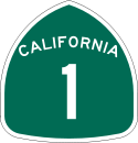 California State Route 1State Route 1 , more often called Highway 1, is a state highway that runs along much of the Pacific coast of the U.S. state of California. It is famous for running along some of the most beautiful coastlines in the world, leading to its designation as an All-American Road.Highway 1 does not run...
 - State Route 23
 California State Route 23State Route 23 is a state highway in the U.S. state of California. The route runs roughly from Fillmore to Malibu. This route is part of the California Freeway and Expressway System.-Route description:...
 - State Route 33
 California State Route 33State Route 33 is a north–south state highway in the U.S. state of California. SR 33 replaced part of U.S. Route 399 in 1964 during the "great renumbering" of routes. In the unincorporated sections of Kern County it is known as the West Side Highway...
 - State Route 34
 California State Route 34State Route 34 is a short state highway in the U.S. state of California.-Route description:SR 34 is part of the California Freeway and Expressway System....
 - State Route 118
 California State Route 118State Route 118 is a state highway in the U.S. state of California that begins running west to east through Ventura and Los Angeles counties in southern California. It travels from Saticoy in Ventura County east to Lake View Terrace in Los Angeles...
 - State Route 126
 California State Route 126State Route 126 is a highway in Ventura and Los Angeles counties, California. The route runs from U.S. Route 101 in Ventura to Interstate 5 in Santa Clarita...
 - State Route 150
 California State Route 150State Route 150 is a state highway in the U.S. state of California. It runs from Santa Paula to U.S. Route 101 near the Ventura/Santa Barbara County line. It is a two-lane road...
 - State Route 232
 California State Route 232State Route 232 is a state highway in Ventura County, California. It serves as a connector between SR 1, US 101, and SR 118.-Route description:...
Unconstructed
- State Route 257

Public transportation
Ventura County is served by AmtrakAmtrak
The National Railroad Passenger Corporation, doing business as Amtrak , is a government-owned corporation that was organized on May 1, 1971, to provide intercity passenger train service in the United States. "Amtrak" is a portmanteau of the words "America" and "track". It is headquartered at Union...
and Metrolink
Metrolink (Southern California)
Metrolink is a commuter rail system serving Los Angeles and the surrounding area of Southern California; it currently consists of six lines and 55 stations using of track....
trains, as well as Greyhound Lines
Greyhound Lines
Greyhound Lines, Inc., based in Dallas, Texas, is an intercity common carrier of passengers by bus serving over 3,700 destinations in the United States, Canada and Mexico, operating under the well-known logo of a leaping greyhound. It was founded in Hibbing, Minnesota, USA, in 1914 and...
,
Gold Coast Transit
Gold Coast Transit
Gold Coast Transit, formerly known as South Coast Area Transit , is a municipal bus operator in western Ventura County, California, serving Ventura, Oxnard, Port Hueneme, Ojai, and the adjoining areas of unincorporated Ventura County....
(formerly South Coast Area Transit), and VISTA
Ventura Intercity Service Transit Authority
Ventura Intercity Service Transit Authority, or VISTA is apublic transit agency providing bus service in Ventura County, California.It is intended to provide an intercity bus service between Ventura, Oxnard, Camarillo, Thousand Oaks,...
buses. The cities of Camarillo
Camarillo, California
Camarillo is a city in Ventura County, California, United States. The population was 65,201 at the 2010 census, up from 57,084 at the 2000 census. The Ventura Freeway Camarillo is a city in Ventura County, California, United States. The population was 65,201 at the 2010 census, up from 57,084 at...
, Simi Valley
Simi Valley, California
-2010:The 2010 United States Census reported that Simi Valley had a population of 124,237. The population density was 2,940.8 people per square mile...
and Thousand Oaks
Thousand Oaks, California
Thousand Oaks is a city in southeastern Ventura County, California, in the United States. It was named after the many oak trees that grace the area, and the city seal is adorned with an oak....
have their own small bus systems.
Island Packers ferries connect Ventura with the five islands of Channel Islands National Park
Channel Islands National Park
- External links :* Official site: * *...
.
Airports
- Oxnard AirportOxnard AirportOxnard Airport is a public airport located one mile west of the central business district of Oxnard, a city in Ventura County, California, USA. The airport covers and has one runway. Oxnard Airport is managed by the Ventura County Department of Airports.- History :Ventura County opened Oxnard...
, just west of Downtown Oxnard, is a general aviation airport.
- Camarillo AirportCamarillo AirportCamarillo Airport is a public airport located three miles west of the central business district of Camarillo, a city in Ventura County, California, United States. It is roughly equidistant from Los Angeles, CA and Santa Barbara, CA although it is inland...
, formerly a US Air Force Base, is a general aviation airport located south of the City of Camarillo. It is the current base of operations of the Ventura County Sheriff's Department Aviation Unit and the home of the VCSD's Training Facility and Academy, the Ventura County Criminal Justice Training Center. The Camarillo Airport also serves as the base of operations for the Ventura County Fire DepartmentVentura County Fire DepartmentThe Ventura County Fire Department provides fire protection and emergency response services for the unincorporated areas of Ventura County, California, and for six other cities within the county. Together, these areas compose the Ventura County Fire Protection District in the state of California,...
and facilitates the Oxnard College Regional Fire Academy and the Ventura County Reserve Officers Training Center.
- Santa Paula AirportSanta Paula AirportSanta Paula Airport is a privately owned public-use airport located one mile southeast of the central business district of Santa Paula, a city in Ventura County, California, USA...
is a privately owned airport; however, it is open to the public for general aviation.
Libraries
Public Libraries: Ventura County LibraryVentura County Library
is a public library system of 13 libraries in Ventura County, California. Ventura County Library may be found online at http://www.vencolibrary.org/....
- 14 locations, Oxnard Public Library, Thousand Oaks Library, Moorpark City Library, and Blanchard Community Library (in Santa Paula).
Academic Libraries: California State University Channel Islands, California Lutheran University
California Lutheran University
California Lutheran University is a university of the Evangelical Lutheran Church in America located in Thousand Oaks, California.-Mission statement:The University's mission statement is as follows:...
, St. Thomas Aquinas College, Moorpark College
Moorpark College
Moorpark College is a California state college located on a property reclining on a hill in Moorpark, a town in Ventura County, California. It was established in 1967 and as of 2006, had an enrollment of 16,580 students and 175 full-time faculty members....
, Oxnard College
Oxnard College
Oxnard College is a California-state funded community college located in Oxnard, California. It was established in 1975. It serves the Oxnard Plain cities of Oxnard, Camarillo, and the town of Port Hueneme. The college offers two year degrees, as well as career and technical education programs to...
, and Ventura College
Ventura College
Ventura College is a California-state funded community college located in Ventura, California, USA. Established in 1925, the college has a campus with an enrollment of 14,456 students. The college is part of the Ventura County Community College District....
.
Other: Ronald Reagan Presidential Library
Ronald Reagan Presidential Library
The Ronald Reagan Presidential Library and Center for Public Affairs is the presidential library and final resting place of Ronald Wilson Reagan, the 40th President of the United States. Designed by Hugh Stubbins and Associates, the library is located in Simi Valley, California, about northwest of...
, Ventura County Law Library.
Politics
| Year | GOP Republican Party (United States) The Republican Party is one of the two major contemporary political parties in the United States, along with the Democratic Party. Founded by anti-slavery expansion activists in 1854, it is often called the GOP . The party's platform generally reflects American conservatism in the U.S... |
DEM Democratic Party (United States) The Democratic Party is one of two major contemporary political parties in the United States, along with the Republican Party. The party's socially liberal and progressive platform is largely considered center-left in the U.S. political spectrum. The party has the lengthiest record of continuous... |
Others |
|---|---|---|---|
| 2008 United States presidential election, 2008 The United States presidential election of 2008 was the 56th quadrennial presidential election. It was held on November 4, 2008. Democrat Barack Obama, then the junior United States Senator from Illinois, defeated Republican John McCain, the senior U.S. Senator from Arizona. Obama received 365... |
55.3% 187,601 | 2.2% 7,587 | |
| 2004 United States presidential election, 2004 The United States presidential election of 2004 was the United States' 55th quadrennial presidential election. It was held on Tuesday, November 2, 2004. Republican Party candidate and incumbent President George W. Bush defeated Democratic Party candidate John Kerry, the then-junior U.S. Senator... |
47.3% 148,859 | 1.3% 4,020 | |
| 2000 United States presidential election, 2000 The United States presidential election of 2000 was a contest between Republican candidate George W. Bush, then-governor of Texas and son of former president George H. W. Bush , and Democratic candidate Al Gore, then-Vice President.... |
47.1% 133,258 | 4.7% 13,261 | |
| 1996 United States presidential election, 1996 The United States presidential election of 1996 was a contest between the Democratic national ticket of President Bill Clinton of Arkansas and Vice President Al Gore of Tennessee and the Republican national ticket of former Senator Bob Dole of Kansas for President and former Housing Secretary Jack... |
44.1% 110,772 | 12.4% 31,220 | |
| 1992 United States presidential election, 1992 The United States presidential election of 1992 had three major candidates: Incumbent Republican President George Bush; Democratic Arkansas Governor Bill Clinton, and independent Texas businessman Ross Perot.... |
37.0% 99,011 | 27.5% 73,725 | |
| 1988 United States presidential election, 1988 The United States presidential election of 1988 featured no incumbent president, as President Ronald Reagan was unable to seek re-election after serving the maximum two terms allowed by the Twenty-second Amendment. Reagan's Vice President, George H. W. Bush, won the Republican nomination, while the... |
37.2% 89,065 | 1.2% 2,804 | |
| 1984 United States presidential election, 1984 The United States presidential election of 1984 was a contest between the incumbent President Ronald Reagan, the Republican candidate, and former Vice President Walter Mondale, the Democratic candidate. Reagan was helped by a strong economic recovery from the deep recession of 1981–1982... |
30.2% 66,550 | 1.2% 2,529 | |
| 1980 United States presidential election, 1980 The United States presidential election of 1980 featured a contest between incumbent Democrat Jimmy Carter and his Republican opponent, Ronald Reagan, as well as Republican Congressman John B. Anderson, who ran as an independent... |
29.5% 56,311 | 10.2% 19,409 | |
| 1976 United States presidential election, 1976 The United States presidential election of 1976 followed the resignation of President Richard Nixon in the wake of the Watergate scandal. It pitted incumbent President Gerald Ford, the Republican candidate, against the relatively unknown former governor of Georgia, Jimmy Carter, the Democratic... |
44.1% 68,529 | 2.7% 4,201 | |
| 1972 United States presidential election, 1972 The United States presidential election of 1972 was the 47th quadrennial United States presidential election. It was held on November 7, 1972. The Democratic Party's nomination was eventually won by Senator George McGovern, who ran an anti-war campaign against incumbent Republican President Richard... |
32.7% 49,307 | 4.1% 6,188 | |
| 1968 United States presidential election, 1968 The United States presidential election of 1968 was the 46th quadrennial United States presidential election. Coming four years after Democrat Lyndon B. Johnson won in a historic landslide, it saw Johnson forced out of the race and Republican Richard Nixon elected... |
41.1% 47,794 | 7.5% 8,762 | |
| 1964 United States presidential election, 1964 The United States presidential election of 1964 was held on November 3, 1964. Incumbent President Lyndon B. Johnson had come to office less than a year earlier following the assassination of his predecessor, John F. Kennedy. Johnson, who had successfully associated himself with Kennedy's... |
58.8% 57,805 | 0.2% 169 | |
| 1960 United States presidential election, 1960 The United States presidential election of 1960 was the 44th American presidential election, held on November 8, 1960, for the term beginning January 20, 1961, and ending January 20, 1965. The incumbent president, Republican Dwight D. Eisenhower, was not eligible to run again. The Republican Party... |
50.0% 35,334 | 0.5% 315 | |
| 1956 United States presidential election, 1956 The United States presidential election of 1956 saw a popular Dwight D. Eisenhower successfully run for re-election. The 1956 election was a rematch of 1952, as Eisenhower's opponent in 1956 was Democrat Adlai Stevenson, whom Eisenhower had defeated four years earlier.Incumbent President Eisenhower... |
49.8% 26,276 | 0.3% 149 | |
| 1952 United States presidential election, 1952 The United States presidential election of 1952 took place in an era when Cold War tension between the United States and the Soviet Union was escalating rapidly. In the United States Senate, Republican Senator Joseph McCarthy of Wisconsin had become a national figure after chairing congressional... |
47.0% 21,967 | 0.6% 256 | |
| 1948 United States presidential election, 1948 The United States presidential election of 1948 is considered by most historians as the greatest election upset in American history. Virtually every prediction indicated that incumbent President Harry S. Truman would be defeated by Republican Thomas E. Dewey. Truman won, overcoming a three-way... |
54.8% 18,100 | 3.1% 1,019 | |
| 1944 United States presidential election, 1944 The United States presidential election of 1944 took place while the United States was preoccupied with fighting World War II. President Franklin D. Roosevelt had been in office longer than any other president, but remained popular. Unlike 1940, there was little doubt that Roosevelt would run for... |
59.3% 16,342 | 0.5% 131 | |
| 1940 United States presidential election, 1940 The United States presidential election of 1940 was fought in the shadow of World War II as the United States was emerging from the Great Depression. Incumbent President Franklin D. Roosevelt , a Democrat, broke with tradition and ran for a third term, which became a major issue... |
57.0% 15,182 | 0.9% 227 | |
| 1936 United States presidential election, 1936 The United States presidential election of 1936 was the most lopsided presidential election in the history of the United States in terms of electoral votes. In terms of the popular vote, it was the third biggest victory since the election of 1820, which was not seriously contested.The election took... |
63.1% 13,384 | 1.1% 235 | |
| 1932 United States presidential election, 1932 The United States presidential election of 1932 took place as the effects of the Wall Street Crash of 1929, the Smoot-Hawley Tariff Act of 1930, the Revenue Act of 1932, and the Great Depression were being felt intensely across the country. President Herbert Hoover's popularity was falling as... |
58.8% 10,903 | 3.9% 724 | |
| 1928 United States presidential election, 1928 The United States presidential election of 1928 pitted Republican Herbert Hoover against Democrat Al Smith. The Republicans were identified with the booming economy of the 1920s, whereas Smith, a Roman Catholic, suffered politically from Anti-Catholic prejudice, his anti-prohibitionist stance, and... |
28.9% 3,717 | 0.9% 117 | |
| 1924 United States presidential election, 1924 The United States presidential election of 1924 was won by incumbent President Calvin Coolidge, the Republican candidate.Coolidge was vice-president under Warren G. Harding and became president in 1923 when Harding died in office. Coolidge was given credit for a booming economy at home and no... |
10.4% 911 | 24.4% 2,139 | |
| 1920 United States presidential election, 1920 The United States presidential election of 1920 was dominated by the aftermath of World War I and a hostile response to certain policies of Woodrow Wilson, the Democratic president. The wartime economic boom had collapsed. Politicians were arguing over peace treaties and the question of America's... |
19.0% 1,305 | 5.0% 347 |
Unlike most other areas of Coastal California
Coastal California
Coastal California refers to the coastal regions of the US state of California. The term is not primarily geographical as it also describes an area distinguished by sociological, economical and political attributes...
, Ventura County tends to support the Republican Party in local and national elections. While Republicans used to win a large majority of votes throughout the 1970s and 1980s, no party has received more than 55% of the county's vote since 1992. Prior to Barack Obama
Barack Obama
Barack Hussein Obama II is the 44th and current President of the United States. He is the first African American to hold the office. Obama previously served as a United States Senator from Illinois, from January 2005 until he resigned following his victory in the 2008 presidential election.Born in...
's victory in the county in 2008
United States presidential election, 2008
The United States presidential election of 2008 was the 56th quadrennial presidential election. It was held on November 4, 2008. Democrat Barack Obama, then the junior United States Senator from Illinois, defeated Republican John McCain, the senior U.S. Senator from Arizona. Obama received 365...
, the last Democrat to win a majority was Lyndon Johnson
Lyndon B. Johnson
Lyndon Baines Johnson , often referred to as LBJ, was the 36th President of the United States after his service as the 37th Vice President of the United States...
in 1964
United States presidential election, 1964
The United States presidential election of 1964 was held on November 3, 1964. Incumbent President Lyndon B. Johnson had come to office less than a year earlier following the assassination of his predecessor, John F. Kennedy. Johnson, who had successfully associated himself with Kennedy's...
, though Democrat Bill Clinton carried the county by a plurality in 1992
United States presidential election, 1992
The United States presidential election of 1992 had three major candidates: Incumbent Republican President George Bush; Democratic Arkansas Governor Bill Clinton, and independent Texas businessman Ross Perot....
and 1996
United States presidential election, 1996
The United States presidential election of 1996 was a contest between the Democratic national ticket of President Bill Clinton of Arkansas and Vice President Al Gore of Tennessee and the Republican national ticket of former Senator Bob Dole of Kansas for President and former Housing Secretary Jack...
.
Most of the county's area, including inland areas and the cities of Thousand Oaks
Thousand Oaks, California
Thousand Oaks is a city in southeastern Ventura County, California, in the United States. It was named after the many oak trees that grace the area, and the city seal is adorned with an oak....
and Moorpark
Moorpark, California
Moorpark is a city in Southern California. It was founded in 1900 by Robert Poindexter, presumably named after the moorpark apricots that grew in the area. The city has experienced a great amount of growth since the late 1970s...
, lies in the 24th district
California's 24th congressional district
California's 24th congressional district covers most of Ventura and inland Santa Barbara counties.The district is currently represented by Republican Elton Gallegly.-Voting:-List of representatives:-Election results:-1952:...
, which has a PVI of R +5 (meaning that based on the presidential election results of 2000 and 2004, the district is 5% more Republican than the nation) and is represented by Republican Elton Gallegly
Elton Gallegly
Elton William Gallegly is the U.S. Representative for , and previously the 23rd and 21st, serving in Congress since 1993. He is a member of the Republican Party.-Early life, education, and pre-congressional career:...
. Coastal regions of Ventura County along with the cities of Oxnard
Oxnard, California
Oxnard is the 113th largest city in the United States, 19th largest city in California and largest city in Ventura County, California, by way of population. It is located at the western edge of the fertile Oxnard Plain, and is an important agricultural center, with its distinction as the...
and Ventura
Ventura, California
Ventura is the county seat of Ventura County, California, United States, incorporated in 1866. The population was 106,433 at the 2010 census, up from 100,916 at the 2000 census. Ventura is accessible via U.S...
, the 23rd district
California's 23rd congressional district
California's 23rd congressional district is a congressional district in the U.S. state of California that runs along the Pacific coasts of Ventura, Santa Barbara and San Luis Obispo counties...
, which includes has a Cook Partisan Index (CPI) rating of D +9 and is currently represented by Democrat Lois Capps. In the State Senate
California State Senate
The California State Senate is the upper house of the California State Legislature. There are 40 state senators. The state legislature meets in the California State Capitol in Sacramento. The Lieutenant Governor is the ex officio President of the Senate and may break a tied vote...
, Ventura is part of the 17th, 19th, and 23rd Senate districts, which are held by Republicans Sharon Runner and Tony Strickland
Tony Strickland
Anthony A. "Tony" Strickland is a California State Senator, representing the 19th District. Strickland is a member of the Republican Party and a former Assemblyman, representing the 37th District from 1998 to 2004.-Early life:...
and Democrat Fran Pavley
Fran Pavley
Frances J. "Fran" Pavley is a Democratic politician who currently represents Senate District 23, including portions of Los Angeles and Ventura Counties in the California Legislature. She previously served as a California Assemblywoman and as the first mayor of the Southern California community of...
, respectively. In the State Assembly
California State Assembly
The California State Assembly is the lower house of the California State Legislature. There are 80 members in the Assembly, representing an approximately equal number of constituents, with each district having a population of at least 420,000...
, Ventura is in the 35th, 37th, 38th, and 41st districts. The 35th and 41st districts are held by Democrats Das Williams
Das Williams
Das Williams is an American politician currently serving in the California State Assembly. He is a Democrat representing the 35th district, encompassing parts of Santa Barbara and Ventura counties...
and Julia Brownley
Julia Brownley
Julia Brownley is a California State Assemblywoman representing California's 41st Assembly District . She was elected to the Assembly on November 7, 2006. She is a Democrat. Before her political career, Brownley hired by several companies in market management...
, respectively; the 37th and 38th districts are held by Republicans Jeff Gorell
Jeff Gorell
Jeff Gorell is a Republican politician from California. In 2010, Gorell was elected to the State Legislature to serve as Assembly Member for the 37th Assembly District in California.-Local business owner:...
and Cameron Smyth
Cameron Smyth
Cameron Smyth is a Republican who has represented California's 38th Assembly district since December 2006. He succeeded Keith Richman who was term-limited...
, respectively.
Current county supervisor
County board of supervisors
The Board of Supervisors is the body that supervises the operation of county government in all counties in Arizona, California, Iowa, Mississippi, Virginia, Wisconsin, and Sussex County, New Jersey as well as a handful of counties in New York...
s are Steve Bennett, Linda Parks, Kathy Long, Peter Foy, and John C. Zaragoza. Geoff Dean is the sheriff of the Ventura County Sheriff's Department. Bob Roper is the chief of the Ventura County Fire Department
Ventura County Fire Department
The Ventura County Fire Department provides fire protection and emergency response services for the unincorporated areas of Ventura County, California, and for six other cities within the county. Together, these areas compose the Ventura County Fire Protection District in the state of California,...
.
Republicans have historically held the registration advantage, but on March 3, 2008, Democratic registration surpassed Republican registration. The cities of Camarillo, Moorpark, Simi Valley, and Thousand Oaks all have voter rolls with Republican pluralities. The remaining cities and towns in the county have a Democratic plurality or majority on the voter rolls, while the unincorporated areas are split almost evenly between the parties.
Demographics
2010
The 2010 United States Census reported that Ventura County had a population of 823,318. The racial makeup of Ventura County was 565,804 (68.7%) White, 15,163 (1.8%) African American, 8,068 (1.0%) Native American, 55,446 (6.7%) Asian, 1,643 (0.2%) Pacific Islander, 140,253 (17.0%) from other racesRace (United States Census)
Race and ethnicity in the United States Census, as defined by the Federal Office of Management and Budget and the United States Census Bureau, are self-identification data items in which residents choose the race or races with which they most closely identify, and indicate whether or not they are...
, and 36,941 (4.5%) from two or more races. Hispanic or Latino of any race were 331,567 persons (40.3%).
| Population reported at 2010 United States Census | |||||||||
|---|---|---|---|---|---|---|---|---|---|
Ventura County, California Ventura County is a county in the southern part of the U.S. state of California. It is located on California's Pacific coast. It is often referred to as the Gold Coast, and has a reputation of being one of the safest populated places and one of the most affluent places in the country... |
Population |
American |
American |
|
Islander |
races Race (United States Census) Race and ethnicity in the United States Census, as defined by the Federal Office of Management and Budget and the United States Census Bureau, are self-identification data items in which residents choose the race or races with which they most closely identify, and indicate whether or not they are... |
more races |
or Latino (of any race) |
|
| Ventura County Ventura County, California Ventura County is a county in the southern part of the U.S. state of California. It is located on California's Pacific coast. It is often referred to as the Gold Coast, and has a reputation of being one of the safest populated places and one of the most affluent places in the country... |
823,318 | 565,804 | 15,163 | 8,068 | 55,446 | 1,643 | 140,253 | 36,941 | 331,567 |
cities and towns |
Population |
American |
American |
|
Islander |
races Race (United States Census) Race and ethnicity in the United States Census, as defined by the Federal Office of Management and Budget and the United States Census Bureau, are self-identification data items in which residents choose the race or races with which they most closely identify, and indicate whether or not they are... |
more races |
or Latino (of any race) |
|
| Camarillo Camarillo, California Camarillo is a city in Ventura County, California, United States. The population was 65,201 at the 2010 census, up from 57,084 at the 2000 census. The Ventura Freeway Camarillo is a city in Ventura County, California, United States. The population was 65,201 at the 2010 census, up from 57,084 at... |
65,201 | 48,947 | 1,216 | 397 | 6,633 | 116 | 4,774 | 3,118 | 14,958 |
| Fillmore Fillmore, California Fillmore is a city in Ventura County, California, United States. The population was 15,002 at the 2010 census, up from 13,643 at the 2000 census.- History :... |
15,002 | 8,581 | 75 | 180 | 155 | 12 | 5,204 | 795 | 11,212 |
| Moorpark Moorpark, California Moorpark is a city in Southern California. It was founded in 1900 by Robert Poindexter, presumably named after the moorpark apricots that grew in the area. The city has experienced a great amount of growth since the late 1970s... |
34,421 | 25,860 | 533 | 248 | 2,352 | 50 | 3,727 | 1,651 | 10,813 |
| Ojai Ojai, California Ojai is a city in Ventura County, California, USA. It is situated in the Ojai Valley , surrounded by hills and mountains. The population was 7,461 at the 2010 census, down from 7,862 at the 2000 census.-History:Chumash Indians were the early inhabitants of the valley... |
7,461 | 6,555 | 42 | 47 | 158 | 1 | 440 | 218 | 1,339 |
| Oxnard Oxnard, California Oxnard is the 113th largest city in the United States, 19th largest city in California and largest city in Ventura County, California, by way of population. It is located at the western edge of the fertile Oxnard Plain, and is an important agricultural center, with its distinction as the... |
197,899 | 95,346 | 5,771 | 2,953 | 14,550 | 658 | 69,527 | 9,094 | 145,551 |
| Port Hueneme Port Hueneme, California Port Hueneme is a small beach city in Ventura County, California surrounded by the city of Oxnard and the Pacific Ocean. The name derives from the Spanish spelling of the Chumash wene me, meaning "Resting Place". The area was discovered by Juan Rodríguez Cabrillo in the mid 16th century... |
21,723 | 12,357 | 1,111 | 295 | 1,299 | 119 | 5,224 | 1,318 | 11,360 |
| Santa Paula Santa Paula, California Santa Paula is a city within Ventura County, California, United States. The population was 29,321 at the 2010 census, up from 28,598 at the 2000 census... |
29,321 | 18,458 | 152 | 460 | 216 | 24 | 8,924 | 1,087 | 23,299 |
| Simi Valley Simi Valley, California -2010:The 2010 United States Census reported that Simi Valley had a population of 124,237. The population density was 2,940.8 people per square mile... |
124,237 | 93,597 | 1,739 | 761 | 11,555 | 178 | 10,685 | 5,722 | 28,938 |
| Thousand Oaks Thousand Oaks, California Thousand Oaks is a city in southeastern Ventura County, California, in the United States. It was named after the many oak trees that grace the area, and the city seal is adorned with an oak.... |
126,683 | 101,702 | 1,674 | 497 | 11,043 | 146 | 6,869 | 4,752 | 21,341 |
| Ventura Ventura, California Ventura is the county seat of Ventura County, California, United States, incorporated in 1866. The population was 106,433 at the 2010 census, up from 100,916 at the 2000 census. Ventura is accessible via U.S... |
106,433 | 81,553 | 1,724 | 1,287 | 3,663 | 206 | 12,486 | 5,514 | 33,874 |
places Census-designated place A census-designated place is a concentration of population identified by the United States Census Bureau for statistical purposes. CDPs are delineated for each decennial census as the statistical counterparts of incorporated places such as cities, towns and villages... |
Population |
American |
American |
|
Islander |
races Race (United States Census) Race and ethnicity in the United States Census, as defined by the Federal Office of Management and Budget and the United States Census Bureau, are self-identification data items in which residents choose the race or races with which they most closely identify, and indicate whether or not they are... |
more races |
or Latino (of any race) |
|
| Bell Canyon Bell Canyon, California Bell Canyon is a census-designated place in Ventura County, California. Bell Canyon is a residential unincorporated community located near West Hills and the western San Fernando Valley in the Simi Hills. Although only minutes from the Los Angeles city limits, Bell Canyon is a Horse Community. ... |
2,049 | 1,724 | 58 | 4 | 179 | 0 | 10 | 74 | 103 |
| Casa Conejo Casa Conejo, California Casa Conejo is a census-designated place in Ventura County, California, United States. It was the first planned community in Newbury Park, built between 1960 and 1965. The community is bordered by Old Conejo Road and the US 101 to the North, Borchard Road to the South, Jenny Dr. to the West, and... |
3,249 | 2,560 | 27 | 20 | 160 | 4 | 327 | 151 | 851 |
| Channel Islands Beach Channel Islands Beach, California Channel Islands Beach is a census-designated place in Ventura County, California, United States. The population was 3,103 at the 2010 census, down from 3,142 at the 2000 census.-Geography:Channel Islands Beach is located at .... |
3,103 | 2,712 | 27 | 16 | 108 | 6 | 103 | 131 | 402 |
| El Rio El Rio, California El Rio is a small unincorporated census-designated town in Ventura County, California, USA, on the northeast side of the 101 Freeway and Oxnard, and south of the Santa Clara River... |
7,198 | 3,495 | 58 | 201 | 73 | 24 | 3,027 | 320 | 6,188 |
| Lake Sherwood Lake Sherwood, California Lake Sherwood is a unincorporated community and a census-designated place in the Santa Monica Mountains, in Ventura County, California overlooking the lake of the same name. It is south of the city of Thousand Oaks, and west of Westlake Village. The ZIP Code is 91361, and the community is inside... |
1,527 | 1,368 | 5 | 1 | 101 | 0 | 9 | 43 | 52 |
| Meiners Oaks Meiners Oaks, California Meiners Oaks is a census-designated place in Ventura County, California, United States. The population was 3,571 at the 2010 census, one person more than the 3,750 counted at the 2000 census.-Geography:... |
3,571 | 2,789 | 14 | 58 | 51 | 1 | 549 | 109 | 1,068 |
| Mira Monte Mira Monte, California Mira Monte is a census-designated place in Ventura County, California, United States. According to the 2010 census, the population of Mira Monte is 6,845, down from 7,177 at the 2000 census.-Geography:... |
6,854 | 5,989 | 43 | 61 | 129 | 3 | 406 | 223 | 1,254 |
| Oak Park Oak Park, California Oak Park is a census-designated place located in the Simi Hills, in Ventura County, California. As of the 2010 census, Oak Park had a population of 14,266, up from 14,225 at the 2000 census... |
13,811 | 11,473 | 141 | 32 | 1,556 | 9 | 162 | 438 | 826 |
| Oak View Oak View, California Oak View is a census-designated place in Ventura County, California, United States located in the western portion of the Ojai Valley situated between the towns of Casitas Springs and Mira Monte . At the 2010 census, the population of Oak View was 4,066, down from 4,199 at the 2000 census, making... |
4,066 | 3,227 | 11 | 63 | 34 | 3 | 575 | 153 | 1,217 |
| Piru Piru, California Piru is a small unincorporated census-designated town located in eastern Ventura County, California, in the Santa Clara River Valley near the Santa Clara River and Highway 126, about seven miles east of Fillmore and about west of Interstate 5. The population was 2,063 at the 2010 census, up from... |
2,063 | 1,063 | 16 | 43 | 11 | 0 | 830 | 100 | 1,748 |
| Santa Rosa Valley Santa Rosa Valley, California Santa Rosa Valley is a census-designated place in Ventura County, California. Santa Rosa Valley sits at an elevation of . The 2010 United States census reported Santa Rosa Valley's population was 3,334.-Geography:... |
3,334 | 2,904 | 23 | 13 | 187 | 4 | 102 | 101 | 353 |
| Santa Susana Santa Susana, California Santa Susana is a census-designated place in Ventura County, California. Santa Susana sits at an elevation of . The 2010 United States census reported Santa Susana's population was 1,037.-Geography:... |
1,037 | 904 | 17 | 2 | 23 | 0 | 33 | 58 | 156 |
| Saticoy Saticoy, California Saticoy is an unincorporated town and census-designated place in Ventura County, California. It lies in the Santa Clara River Valley, south of the intersection of Wells Road and the Santa Paula Freeway, on the east side of Ventura, and north of the Santa Clara River at the head of the delta... |
1,029 | 413 | 9 | 29 | 2 | 0 | 508 | 68 | 895 |
communities Unincorporated area In law, an unincorporated area is a region of land that is not a part of any municipality.To "incorporate" in this context means to form a municipal corporation, a city, town, or village with its own government. An unincorporated community is usually not subject to or taxed by a municipal government... |
Population |
American |
American |
|
Islander |
races Race (United States Census) Race and ethnicity in the United States Census, as defined by the Federal Office of Management and Budget and the United States Census Bureau, are self-identification data items in which residents choose the race or races with which they most closely identify, and indicate whether or not they are... |
more races |
or Latino (of any race) |
|
| All others not CDPs (combined) | 42,046 | 32,227 | 677 | 400 | 1,208 | 79 | 5,752 | 1,703 | 13,769 |
2000
As of the censusCensus
A census is the procedure of systematically acquiring and recording information about the members of a given population. It is a regularly occurring and official count of a particular population. The term is used mostly in connection with national population and housing censuses; other common...
of 2000, there were 753,197 people, 243,234 households, and 182,911 families living in the county. The population density
Population density
Population density is a measurement of population per unit area or unit volume. It is frequently applied to living organisms, and particularly to humans...
was 408 people per square mile (158/km²). There were 251,712 housing units at an average density of 136 per square mile (53/km²). The racial makeup of the county was 69.93% White
Race (United States Census)
Race and ethnicity in the United States Census, as defined by the Federal Office of Management and Budget and the United States Census Bureau, are self-identification data items in which residents choose the race or races with which they most closely identify, and indicate whether or not they are...
, 5.35% Asian
Race (United States Census)
Race and ethnicity in the United States Census, as defined by the Federal Office of Management and Budget and the United States Census Bureau, are self-identification data items in which residents choose the race or races with which they most closely identify, and indicate whether or not they are...
, 1.95% Black
Race (United States Census)
Race and ethnicity in the United States Census, as defined by the Federal Office of Management and Budget and the United States Census Bureau, are self-identification data items in which residents choose the race or races with which they most closely identify, and indicate whether or not they are...
or African American
Race (United States Census)
Race and ethnicity in the United States Census, as defined by the Federal Office of Management and Budget and the United States Census Bureau, are self-identification data items in which residents choose the race or races with which they most closely identify, and indicate whether or not they are...
, 0.94% Native American
Race (United States Census)
Race and ethnicity in the United States Census, as defined by the Federal Office of Management and Budget and the United States Census Bureau, are self-identification data items in which residents choose the race or races with which they most closely identify, and indicate whether or not they are...
, 0.22% Pacific Islander
Race (United States Census)
Race and ethnicity in the United States Census, as defined by the Federal Office of Management and Budget and the United States Census Bureau, are self-identification data items in which residents choose the race or races with which they most closely identify, and indicate whether or not they are...
, 17.68% from other races
Race (United States Census)
Race and ethnicity in the United States Census, as defined by the Federal Office of Management and Budget and the United States Census Bureau, are self-identification data items in which residents choose the race or races with which they most closely identify, and indicate whether or not they are...
, and 3.93% from two or more races. About one third (33.42%) of the population is Hispanic
Race (United States Census)
Race and ethnicity in the United States Census, as defined by the Federal Office of Management and Budget and the United States Census Bureau, are self-identification data items in which residents choose the race or races with which they most closely identify, and indicate whether or not they are...
or Latino
Race (United States Census)
Race and ethnicity in the United States Census, as defined by the Federal Office of Management and Budget and the United States Census Bureau, are self-identification data items in which residents choose the race or races with which they most closely identify, and indicate whether or not they are...
of any race. 9.8% were of German, 7.7% English
English people
The English are a nation and ethnic group native to England, who speak English. The English identity is of early mediaeval origin, when they were known in Old English as the Anglecynn. England is now a country of the United Kingdom, and the majority of English people in England are British Citizens...
and 7.1% Irish
Irish people
The Irish people are an ethnic group who originate in Ireland, an island in northwestern Europe. Ireland has been populated for around 9,000 years , with the Irish people's earliest ancestors recorded having legends of being descended from groups such as the Nemedians, Fomorians, Fir Bolg, Tuatha...
ancestry according to Census 2000. 67.1% spoke English
English language
English is a West Germanic language that arose in the Anglo-Saxon kingdoms of England and spread into what was to become south-east Scotland under the influence of the Anglian medieval kingdom of Northumbria...
, 26.2% Spanish
Spanish language
Spanish , also known as Castilian , is a Romance language in the Ibero-Romance group that evolved from several languages and dialects in central-northern Iberia around the 9th century and gradually spread with the expansion of the Kingdom of Castile into central and southern Iberia during the...
and 1.5% Tagalog
Tagalog language
Tagalog is an Austronesian language spoken as a first language by a third of the population of the Philippines and as a second language by most of the rest. It is the first language of the Philippine region IV and of Metro Manila...
as their first language.
There were 243,234 households, of which 39.7% had children under the age of 18 living with them, 59.5% were married couples
Marriage
Marriage is a social union or legal contract between people that creates kinship. It is an institution in which interpersonal relationships, usually intimate and sexual, are acknowledged in a variety of ways, depending on the culture or subculture in which it is found...
living together, 10.9% had a female householder with no husband present, and 24.8% were non-families. 18.9% of all households were made up of individuals, and 7.4% had someone living alone who was 65 years of age or older. The average household size was 3.04 and the average family size was 3.46.
In the county the population was spread out, with 28.4% under the age of 18, 9.0% from 18 to 24, 30.7% from 25 to 44, 21.7% from 45 to 64, and 10.2% who were 65 or older. The median age was 34 years. For every 100 females there were 99.7 males. For every 100 females age 18 and over, there were 97.5 males.
The median income for a household in the county was $59,666, and the median income for a family was $65,285. Males had a median income of $45,310, versus $32,216 for females. The per capita income
Per capita income
Per capita income or income per person is a measure of mean income within an economic aggregate, such as a country or city. It is calculated by taking a measure of all sources of income in the aggregate and dividing it by the total population...
for the county was $24,600. About 6.4% of families and 9.2% of the population were below the poverty line, including 11.6% of those under age 18 and 6.3% of those aged 65 or over.
According to an updated 2005 US Census, median
Median
In probability theory and statistics, a median is described as the numerical value separating the higher half of a sample, a population, or a probability distribution, from the lower half. The median of a finite list of numbers can be found by arranging all the observations from lowest value to...
household income was $66,859, while the mean was $85,032. Per capita income
Per capita income
Per capita income or income per person is a measure of mean income within an economic aggregate, such as a country or city. It is calculated by taking a measure of all sources of income in the aggregate and dividing it by the total population...
was up to $29,634, making it the 6th wealthiest county in California.
Environment
In 2010, the County of Ventura completed a solar energy system 492 kilowatts DC in size, on several County buildings. The systems were financed using a solar Power Purchase Agreement, which required no upfront cash from the County. The systems are owned, maintained, and operated by Solar Power Partners and its investors, and were designed and constructed by Solar Power, Inc. The County pays for the solar-generated electricity generated by the system, offsetting a portion of its utility costs.Entertainment
Lake SherwoodLake Sherwood, California
Lake Sherwood is a unincorporated community and a census-designated place in the Santa Monica Mountains, in Ventura County, California overlooking the lake of the same name. It is south of the city of Thousand Oaks, and west of Westlake Village. The ZIP Code is 91361, and the community is inside...
is so called due to its use as the location for Sherwood Forest in the 1922 film, Robin Hood
Robin Hood (1922 film)
Robin Hood is the first motion picture ever to have a Hollywood premiere, held at Grauman's Egyptian Theatre on October 18, 1922. The movie's full title, under which it was copyrighted, is Douglas Fairbanks in Robin Hood, as shown in the illustration at right...
, starring Douglas Fairbanks. The 1938 film, The Adventures of Robin Hood
The Adventures of Robin Hood (film)
The Adventures of Robin Hood is a 1938 American swashbuckler film directed by Michael Curtiz and William Keighley. Filmed in Technicolor, the picture stars Errol Flynn, Olivia de Havilland, Basil Rathbone, and Claude Rains.-Plot:...
, starring Errol Flynn, also had a major scene shot on location at "Sherwood Forest".
On July 23, 1982 actor Vic Morrow
Vic Morrow
Victor "Vic" Morrow was an American actor whose credits include a starring role in the 1960s TV series Combat!, prominent roles in a handful of other television and cinema dramas, and numerous guest roles on television...
and two children actors (My-Ca Dinh Le and Renee Shin-Ye Chen) were filming a helicopter scene for Twilight Zone: The Movie
Twilight Zone: The Movie
Twilight Zone: The Movie is a 1983 science fiction horror film produced by Steven Spielberg and John Landis as a theatrical version of The Twilight Zone, a 1959 and '60s TV series created by Rod Serling. Those starring in the film are: Dan Aykroyd, Albert Brooks, Vic Morrow, Scatman Crothers,...
in the area of Indian Dunes in Ventura County when the helicopter lost control and crashed on top of them. Morrow and Le were decapitated and Chen was fatally crushed.
In 2009, the popular VH1 television show Tool Academy was filmed in Ventura County. In 1963, the touching Korean War
Korean War
The Korean War was a conventional war between South Korea, supported by the United Nations, and North Korea, supported by the People's Republic of China , with military material aid from the Soviet Union...
story The Young and The Brave
The Young and The Brave
The Young and The Brave is a classic feature film released in 1963 by Metro-Goldwyn-Mayer. The film has been recognized by Turner Classic Movies as an historical representation of the war film genre and in 2006, the network executives selected the film for preservation in their archives...
, featuring a brave and resourceful young boy, was filmed in rural areas of Ventura County.
Also, in 2000 the movie Swordfish filmed the final bank scene on East Main Street in Ventura. The building they used is the white building on the corner.34.280823°N 119.294599°W
The movie Back to the Future Part III
Back to the Future Part III
Back to the Future Part III is a 1990 American science fiction comedy Western film. It is the third installment of the Back to the Future trilogy. The film was directed by Robert Zemeckis and starred Michael J. Fox, Christopher Lloyd, Mary Steenburgen, Thomas F. Wilson and Lea Thompson. The film...
filmed the scene where Marty returns to the year 1985 in the time-traveling DeLorean at the railroad crossing at S Ventura Rd & Shoreview Dr in Port Hueneme
Port Hueneme, California
Port Hueneme is a small beach city in Ventura County, California surrounded by the city of Oxnard and the Pacific Ocean. The name derives from the Spanish spelling of the Chumash wene me, meaning "Resting Place". The area was discovered by Juan Rodríguez Cabrillo in the mid 16th century...
Many films including Swordfish
Swordfish (film)
Swordfish is a 2001 crime-thriller film, directed by Dominic Sena and starring John Travolta, Hugh Jackman, Halle Berry, Don Cheadle and Vinnie Jones. The film is an action thriller that was also notable for Halle Berry's first topless scene...
, Little Miss Sunshine
Little Miss Sunshine
Little Miss Sunshine is a 2006 American comedy-drama film. The road movie's plot follows a family's trip to a children's beauty pageant.Little Miss Sunshine was the directorial film debut of the husband-wife team of Jonathan Dayton and Valerie Faris. The screenplay was written by first-time writer...
, Chinatown, Erin Brockovich
Erin Brockovich (film)
Erin Brockovich is a 2000 biographical film directed by Steven Soderbergh. The film is a dramatization of the story of Erin Brockovich, played by Julia Roberts, who fought against the US West Coast energy corporation Pacific Gas and Electric Company. Roberts won the Academy Award, Golden Globe,...
, The Aviator, and The Rock
The Rock (film)
The Rock is a 1996 action film that primarily takes place on Alcatraz Island and in the San Francisco Bay area. It was directed by Michael Bay and stars Sean Connery, Nicolas Cage and Ed Harris. It was produced by Don Simpson and Jerry Bruckheimer and released through Hollywood Pictures. The film...
were partly filmed in Ventura.
Downtown Ventura also hosts the Majestic Ventura Theater, a beautiful early century theatre, which is situated about two blocks away from city hall. It serves as a venue for concerts. The theater has seen many bands such as Gregg Allman
Gregg Allman
Gregory Lenoir Allman , known as Gregg Allman, is a rock and blues singer, keyboardist, guitarist and songwriter, and a founding member of The Allman Brothers Band. He was inducted with the band into the Rock and Roll Hall of Fame in 1995 and received a Lifetime Achievement Award from the Georgia...
, John Prine
John Prine
John Prine is an American country/folk singer-songwriter. He has been active as a recording artist and live performer since the early 1970s.-Biography:...
, The Doors
The Doors
The Doors were an American rock band formed in 1965 in Los Angeles, California, with vocalist Jim Morrison, keyboardist Ray Manzarek, drummer John Densmore, and guitarist Robby Krieger...
, Devo
Devo
Devo is an American band formed in 1973 consisting of members from Kent and Akron, Ohio. The classic line-up of the band includes two sets of brothers, the Mothersbaughs and the Casales . The band had a #14 Billboard chart hit in 1980 with the single "Whip It", and has maintained a cult...
, Van Halen
Van Halen
Van Halen is an American hard rock band formed in Pasadena, California, in 1972. The band has enjoyed success since the release of its debut album, Van Halen, . As of 2007 Van Halen has sold 80 million albums worldwide and has had the most #1 hits on the Billboard Mainstream Rock chart...
, X, Paramore
Paramore
Paramore is an American rock band from Franklin, Tennessee, formed in 2004. The band consists of lead vocalist Hayley Williams, bassist Jeremy Davis, and guitarist Taylor York...
, She Wants Revenge
She Wants Revenge
She Wants Revenge is an American musical duo, based in San Fernando Valley, California. The group's debut album She Wants Revenge was released in early 2006, with three singles to follow...
, Pennywise
Pennywise (band)
Pennywise is a Californian punk rock band from Hermosa Beach, California, formed in 1988. The name is derived from the monster, It, from the Stephen King novel of the same title....
, Red Hot Chili Peppers
Red Hot Chili Peppers
Red Hot Chili Peppers is an American rock band, formed in Los Angeles in 1983. The group's musical style primarily consists of rock with an emphasis on funk, as well as elements from other genres such as punk, hip hop and psychedelic rock...
, Lamb of God
Lamb of God
The title Lamb of God appears in the Gospel of John, with the exclamation of John the Baptist: "Behold the Lamb of God who takes away the sin of the world" in John 1:29 when he sees Jesus....
, Social Distortion
Social Distortion
Social Distortion is an American punk rock band formed in 1978 in Fullerton, California. The band currently consists of Mike Ness , Jonny Wickersham , Brent Harding and David Hidalgo, Jr...
, Bad Religion
Bad Religion
Bad Religion is a punk rock band that formed in Los Angeles in 1979. Their current line-up consists of Greg Graffin , Brett Gurewitz , Jay Bentley , Greg Hetson , Brian Baker and Brooks Wackerman . Gurewitz is also the founder of the label Epitaph Records, which has released almost all of the...
, Thrice
Thrice
Thrice is an American rock band from Irvine, California, formed in 1998. The group was founded by guitarist/vocalist Dustin Kensrue and guitarist Teppei Teranishi while they were in high school....
, Avenged Sevenfold
Avenged Sevenfold
Avenged Sevenfold is an American heavy metal band from Huntington Beach, California. Formed in 1999, the group consists of vocalist M. Shadows, lead guitarist Synyster Gates, rhythm guitarist Zacky Vengeance, bassist Johnny Christ....
, Fugazi, Incubus
Incubus (band)
Incubus is an American rock band from Calabasas, California. The band was formed in 1991 by vocalist Brandon Boyd, lead guitarist Mike Einziger, and drummer Jose Pasillas while enrolled in high school and later expanded to include bassist Alex "Dirk Lance" Katunich, and Gavin "DJ Lyfe" Koppell;...
, Tom Petty
Tom Petty
Thomas Earl "Tom" Petty is an American singer-songwriter and multi-instrumentalist. He is the frontman of Tom Petty and the Heartbreakers and was a founding member of the late 1980s supergroup Traveling Wilburys and Mudcrutch. He has also performed under the pseudonyms of Charlie T...
, America
America (band)
America is an English-American folk rock band that originally included members Gerry Beckley, Dewey Bunnell and Dan Peek. The three members were barely out of their teens when they became a musical sensation during 1972, scoring #1 hits and winning a Grammy for best new musical artist...
, They Might Be Giants
They Might Be Giants
They Might Be Giants is an American alternative rock band formed in 1982 by John Flansburgh and John Linnell. During TMBG's early years Flansburgh and Linnell were frequently accompanied by a drum machine. In the early 1990s, TMBG became a full band. Currently, the members of TMBG are...
, and Modest Mouse
Modest Mouse
Modest Mouse is an American indie rock band formed in 1993 in Issaquah, Washington, by singer/lyricist/guitarist Isaac Brock, drummer Jeremiah Green, and bassist Eric Judy. They are based in Portland, Oregon. Since their 1996 debut album, This Is a Long Drive for Someone with Nothing to Think...
, as well as successful local artists such as Army of Freshmen
Army of Freshmen
Army of Freshmen is an independent 6 piece rock band based out of Ventura, California that has played over 1,000 shows in 43 states and 11 countries.-Early Years :...
, Big Bad Voodoo Daddy
Big Bad Voodoo Daddy
Big Bad Voodoo Daddy is a contemporary swing revival band from southern California. Their notable singles include "Go Daddy-O", "You & Me & the Bottle Makes 3 Tonight ", and "Mr. Pinstripe Suit". The band played the Super Bowl XXXIII half-time show in 1999.The band was originally formed in Ventura,...
, Gregory Hillman, Bruce Kimmell
Bruce Kimmell
Bruce Kimmell is a live touring guitarist and musician. His unique performances include a fusion of Country Music, Bluegrass, and Jazz. He has performed at a variety of public and private venues including shows with The Neville Brothers at the Majestic Ventura Theater.Bruce Kimmell also performed...
, Shim Come Quick
See also
- Burro Flats Painted CaveBurro Flats Painted CaveBurro Flats Painted Cave is in the Burro Flats area of the Simi Hills, located between the Simi Valley, and West Hills and Bell Canyon, in Ventura County of Southern California, United States. It is a Cave containing Chumash Native American pictographs...
- List of schools in the Roman Catholic Archdiocese of Los Angeles
- Los Angeles Times suburban sections
- National Register of Historic Places listings in Ventura County, California
- Ventura County Air Pollution Control DistrictVentura County Air Pollution Control DistrictThe Ventura County Air Pollution Control District , formed in 1968, is the air pollution agency responsible mainly for regulating stationary sources of air pollution for Ventura County...
External links
- Official county website
- Oxnard Transportation Center A Major Transportation Hub of Southern California
- Ventura County Star, largest Ventura County daily news organization, Scripps chain newspaper
- The Ojai and Ventura VIEW, only true locally owned alternative press, a monthly newspaper
- VC Reporter, a weekly chain newsmagazine with a pro-urban developer bias, owned by southland publications corp. based in Pasadena.
- Ventura County Crime Blog, Crime, trials, and reports in Ventura County
- News from Ventura County, from the Los Angeles TimesLos Angeles TimesThe Los Angeles Times is a daily newspaper published in Los Angeles, California, since 1881. It was the second-largest metropolitan newspaper in circulation in the United States in 2008 and the fourth most widely distributed newspaper in the country....
website - Ventura County Air Pollution Control District
- Ventura County Law Library - open to the public
- Ventura County on the National Association Of Counties