
Santa Monica Mountains National Recreation Area
Encyclopedia
The Santa Monica Mountains National Recreation Area or SMMNRA, is a United States
National Recreation Area containing many individual park
s and open space preserves
, located primarily in the Santa Monica Mountains
of Southern California
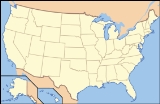
. The SMMNRA is located within the greater Los Angeles
region, with two thirds of the parklands in northwest Los Angeles County
, and the remaining third including a Simi Hills
extension in southeastern Ventura County, California
.
Overall administration is by the National Park Service
, coordinating with state, county, municipal, and university agencies. The Santa Monica Mountains Recreation Area preserves one of the best examples of a Mediterranean climate
ecosystem
in the world. It also protects one of the highest densities of archaeological resources in any mountain range in the world.
of the Transverse Ranges
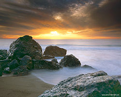
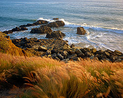
between the Pacific Ocean
and inland valleys. Its southeastern slopes are part of the headwaters of the Los Angeles River
. The California State Park system
owns 42000 acres (16,996.8 ha), the National Park Service
controls 21500 acres (8,700.7 ha), and the rest of the SMMNRA lands are in local agencies parks, university study reserves, and private property conservation easement
s. In size the Santa Monica Mountains National Recreation Area is the largest urban national park in the United States.
has a long tradition that is frequently overlooked by historians who often focus exclusively on the environmental movement of the 1960s and 1970s which culminated with the establishment of the Santa Monica Mountains National Recreation Area in 1978.
which was donated to the city of Los Angeles by Griffith J. Griffith
in 1896.
In 1907 an application was submitted to the Secretary of the Interior
requesting that at least 70,000 acres in the mountains be designated a forest reserve. This time state mineralogist Lewis E. Aubury opposed the venture. He wrote the L.A. Time newspaper stating, “I believe that the lands embraced in the Malibu and Santa Monica districts should not be included in a forest reserve…I shall at once take the matter up with Gifford Pinchot
, forester, Washington, D.C., and endeavor to ascertain his views on the subject, and further protest against the creation of this proposed reserve”. Days later the U. S. Forest Service advised Aubury that it was highly improbable that a forest reserve would be created owning to local opposition and the small amount of public land still remaining in the Santa Monica Mountains.
deposits were discovered in the mountains behind Pacific Palisades in 1925 which led to a lengthy battle between wealthy home owners of the area and land developers. The quarry site was in Traylor Canyon, three miles inland from the sea, between Santa Ynez and Temescal Canyons. Alphonzo Bell
, Sr. was the real estate developer behind the quarry scheme while local opposition was led by Sylvia Morrison, who championed the preservation of the area’s natural beauty.
After much criticism of his original plan, Bell offered a new proposal. Using a new process, he would have the rock pulverized, mixed with water, and pumped via a buried pipeline to the mouth of Santa Ynez Canyon. The pipeline would continue from there along the ocean floor to an offshore buoy where it would be load onboard a waiting ship. Criticism of the plan grew and eventually garnered the ire of local resident Will Rogers
who parodied the plan on the front page of the L.A. Times. The debate raged citywide with such notable public figures as William Mulholland
coming to Bell’s defense.
In an attempt to sway public opinion, Bell urged local residents to take company-sponsored fieldtrips, on foot and on horseback, to the quarry to see the site for themselves. Among the people who took these trips was Sylvia Morrison, who had been an early leader of environmental concerns. She was among the visitors who scrambled up the limestone cliffs on ladders and hiked and rode on horseback through the chaparral
and came away thrilled with the natural beauty of the canyons. “Taking a cue from Yellowstone National Park
, Morrison urged the establishment of Whitestone National Park in the Santa Monica Mountains, named after the by-now infamous cliffs.”
, a lifelong advocate of national parks and considered by many as the designer of the California State Parks system, proposed a network of parks, beaches, playgrounds, and forests to promote the social, economic, and environmental vitality of Los Angeles. Olmsted also advocated for public ownership of at least 10,000 acres of the most scenic beach and mountain landscapes between Topanga and Point Dume
. However, the Olmsted report was essentially killed – only 200 copies were printed – due mainly to civic leaders who put politics ahead of public space.
was created in 1944 marking the establishment of the first state park in the Santa Monica Mountains and the first public land created in the mountains since Griffith Park
in 1896.
plant found in the area.
by local and regional conservationist
s. The Santa Monica Mountains Conservancy
, a California state agency, was created in 1980 for the acquisition of land for preservation as open space, for wildlife and California native plants
habitat preserves
, and for public recreation activities. The SMMNRA is growing by 'mosaic pieces' linking critical habitats, saving unique areas, and expanding existing parks.
The SMMNRA is part of the Rim of the Valley Trail Corridor; the Rim of the Valley Trail is a plan in progress for connecting the parkland and recreational areas of the Conejo, San Fernando, Simi, and La Crescenta Valleys via trailheads and trails in the mountains and valleys.
Entertainer and land speculator Bob Hope
created controversy in the early 1990s when he proposed to sell 5900 acres (2,387.6 ha) of Corral Canyon area land to the federal government in exchange for 59 acres (23.9 ha) of federal parkland in the nearby Cheeseboro Canyon section of Santa Monica Mountains NRA, in order to build an access road to a new 'Jordan Ranch' golf course and housing development. The land swap was never completed, the Jordan Ranch became the Palo Commado Park section, and most of the land for Corral Canyon was later donated by Bob Hope.
The highly visible natural ranch land adjacent to the intersection of U.S. Route 101 and Las Virgenes Road in Calabasas
, formerly the Brent's Junction area and owned by Bob Hope, was acquired by the SMM Conservancy to add to the Las Virgenes View Park of the Santa Monica Mountains NRA lands in June 2010. It is a refreshing open space seen by many traveling by, on the Route 101-Ventura Freeway
now, between the San Fernando
and the Conejo Valley
s since the Spanish El Camino Real
era.
boast a rich history of continuous human occupation dating back more than 10,000 years and contain many nationally significant prehistoric and historic sites. In fact, more than 1,000 archaeological sites are located within the boundary of the Santa Monica Mountains National Recreation Area making it one of the highest densities of archaeological resources found in any mountain range in the world. There are twenty-six known Chumash
pictograph sites with the national recreation area, all sacred to traditional Native American Indians, and include some that are among the most spectacular found anywhere. These pictographs – along with other sites – have been described by the National Park Service
as “unique and a significant world heritage”.
Nearly every major prehistoric and historic theme associated with human interaction and development of the western United States is represented within the park from the early hunters and gathers, to Native American Indian cultures, the Spanish mission and rancho periods, and the American homestead era.
At least 73 archeological sites, historic structures, cultural landscapes, and traditional cultural properties in the Santa Monica Mountains
are potentially eligible for listing on the National Register of Historic Places
.
91360. Recreational opportunities abound, including biking
, birding
, camping
, hiking
, and horseback riding. The Backbone Trail System
runs for nearly 70 miles (112.7 km) across the Santa Monica Mountains between Will Rogers State Park and Point Mugu State Park and is nearly complete from end to end. Channel Islands National Park
lies in the Pacific Ocean
directly to the west.
, Agoura Hills
, Calabasas
, Woodland Hills, and Topanga, California
.
The following parks and areas are managed by the National Park Service in the Santa Monica Mountains NRA:
The following California State Park
s are located within Santa Monica Mountains NRA:
State Beaches in or adjacent to Santa Monica Mountains NRA:
United States
The United States of America is a federal constitutional republic comprising fifty states and a federal district...
National Recreation Area containing many individual park
Park
A park is a protected area, in its natural or semi-natural state, or planted, and set aside for human recreation and enjoyment, or for the protection of wildlife or natural habitats. It may consist of rocks, soil, water, flora and fauna and grass areas. Many parks are legally protected by...
s and open space preserves
Open space reserve
Open space reserve, open space preserve, and open space reservation, are planning and conservation ethics terms used to describe areas of protected or conserved land or water on which development is indefinitely set aside...
, located primarily in the Santa Monica Mountains
Santa Monica Mountains
The Santa Monica Mountains are a Transverse Range in Southern California, along the coast of the Pacific Ocean in the United States.-Geography:...
of Southern California
Southern California
Southern California is a megaregion, or megapolitan area, in the southern area of the U.S. state of California. Large urban areas include Greater Los Angeles and Greater San Diego. The urban area stretches along the coast from Ventura through the Southland and Inland Empire to San Diego...
. The SMMNRA is located within the greater Los Angeles
Los Angeles, California
Los Angeles , with a population at the 2010 United States Census of 3,792,621, is the most populous city in California, USA and the second most populous in the United States, after New York City. It has an area of , and is located in Southern California...
region, with two thirds of the parklands in northwest Los Angeles County
Los Angeles County, California
Los Angeles County is a county in the U.S. state of California. As of 2010 U.S. Census, the county had a population of 9,818,605, making it the most populous county in the United States. Los Angeles County alone is more populous than 42 individual U.S. states...
, and the remaining third including a Simi Hills
Simi Hills
The Simi Hills are a low rocky mountain range of the Transverse Ranges, located in eastern Ventura County and western Los Angeles County, of southern California, United States.-Geography:...
extension in southeastern Ventura County, California
Ventura County, California
Ventura County is a county in the southern part of the U.S. state of California. It is located on California's Pacific coast. It is often referred to as the Gold Coast, and has a reputation of being one of the safest populated places and one of the most affluent places in the country...
.
Overall administration is by the National Park Service
National Park Service
The National Park Service is the U.S. federal agency that manages all national parks, many national monuments, and other conservation and historical properties with various title designations...
, coordinating with state, county, municipal, and university agencies. The Santa Monica Mountains Recreation Area preserves one of the best examples of a Mediterranean climate
Mediterranean climate
A Mediterranean climate is the climate typical of most of the lands in the Mediterranean Basin, and is a particular variety of subtropical climate...
ecosystem
Ecosystem
An ecosystem is a biological environment consisting of all the organisms living in a particular area, as well as all the nonliving , physical components of the environment with which the organisms interact, such as air, soil, water and sunlight....
in the world. It also protects one of the highest densities of archaeological resources in any mountain range in the world.
Geography
The Santa Monica Mountains NRA contains 154095 acres (62,360.1 ha) in the Santa Monica MountainsSanta Monica Mountains
The Santa Monica Mountains are a Transverse Range in Southern California, along the coast of the Pacific Ocean in the United States.-Geography:...
of the Transverse Ranges
Transverse Ranges
The Transverse Ranges are a group of mountain ranges of southern California, in the Pacific Coast Ranges physiographic region that runs along the Pacific coast from Alaska to Mexico in North America. The Transverse Ranges begin at the southern end of the California Coast Ranges and lie between...
between the Pacific Ocean
Pacific Ocean
The Pacific Ocean is the largest of the Earth's oceanic divisions. It extends from the Arctic in the north to the Southern Ocean in the south, bounded by Asia and Australia in the west, and the Americas in the east.At 165.2 million square kilometres in area, this largest division of the World...
and inland valleys. Its southeastern slopes are part of the headwaters of the Los Angeles River
Los Angeles River
The Los Angeles River is a river that starts in the San Fernando Valley, in the Simi Hills and Santa Susana Mountains, and flows through Los Angeles County, California, from Canoga Park in the western end of the San Fernando Valley, nearly southeast to its mouth in Long Beach...
. The California State Park system
California Department of Parks and Recreation
The California Department of Parks and Recreation, also known as California State Parks, manages the California state parks system. The system administers 278 parks and 1.4 million acres , with over of coastline; of lake and river frontage; nearly 15,000 campsites; and of hiking, biking, and...
owns 42000 acres (16,996.8 ha), the National Park Service
National Park Service
The National Park Service is the U.S. federal agency that manages all national parks, many national monuments, and other conservation and historical properties with various title designations...
controls 21500 acres (8,700.7 ha), and the rest of the SMMNRA lands are in local agencies parks, university study reserves, and private property conservation easement
Conservation easement
In the United States, a conservation easement is an encumbrance — sometimes including a transfer of usage rights — which creates a legally enforceable land preservation agreement between a landowner and a government agency or a qualified land...
s. In size the Santa Monica Mountains National Recreation Area is the largest urban national park in the United States.
Park history
The movement to preserve the Santa Monica MountainsSanta Monica Mountains
The Santa Monica Mountains are a Transverse Range in Southern California, along the coast of the Pacific Ocean in the United States.-Geography:...
has a long tradition that is frequently overlooked by historians who often focus exclusively on the environmental movement of the 1960s and 1970s which culminated with the establishment of the Santa Monica Mountains National Recreation Area in 1978.
Griffith Park
The first area in the Santa Monica Mountains set aside for public use was Griffith ParkGriffith Park
Griffith Park is a large municipal park at the eastern end of the Santa Monica Mountains in the Los Feliz neighborhood of Los Angeles, California. The park covers of land, making it one of the largest urban parks in North America...
which was donated to the city of Los Angeles by Griffith J. Griffith
Griffith J. Griffith
Griffith Jenkins Griffith was a Welsh-American industrialist and philanthropist. After amassing a significant fortune from a mining syndicate in the 1880s, Griffith donated to the City of Los Angeles which became Griffith Park, and he bequeathed the money to build the park's Greek Theatre and...
in 1896.
National Forest
During the first decade of the twentieth century, Frederick H. Rindge made several attempts to create a forest reserve in the Santa Monica Mountains. These reserves were precursors to national forests. In 1902 California’s State Mining Bureau examined the area being considered for the establishment of a forest reserve. The resulting report was sent to Washington where the proposal for a reserve was denied.In 1907 an application was submitted to the Secretary of the Interior
Secretary of the Interior
The Secretary of the Interior may refer to:* The United States Secretary of the Interior* The Secretario de Gobernación Secretary of the Interior...
requesting that at least 70,000 acres in the mountains be designated a forest reserve. This time state mineralogist Lewis E. Aubury opposed the venture. He wrote the L.A. Time newspaper stating, “I believe that the lands embraced in the Malibu and Santa Monica districts should not be included in a forest reserve…I shall at once take the matter up with Gifford Pinchot
Gifford Pinchot
Gifford Pinchot was the first Chief of the United States Forest Service and the 28th Governor of Pennsylvania...
, forester, Washington, D.C., and endeavor to ascertain his views on the subject, and further protest against the creation of this proposed reserve”. Days later the U. S. Forest Service advised Aubury that it was highly improbable that a forest reserve would be created owning to local opposition and the small amount of public land still remaining in the Santa Monica Mountains.
Whitestone National Park
LimestoneLimestone
Limestone is a sedimentary rock composed largely of the minerals calcite and aragonite, which are different crystal forms of calcium carbonate . Many limestones are composed from skeletal fragments of marine organisms such as coral or foraminifera....
deposits were discovered in the mountains behind Pacific Palisades in 1925 which led to a lengthy battle between wealthy home owners of the area and land developers. The quarry site was in Traylor Canyon, three miles inland from the sea, between Santa Ynez and Temescal Canyons. Alphonzo Bell
Alphonzo Bell
Alphonzo Edward Bell Sr. was an American oil multi-millionaire, real estate developer, philanthropist, and champion tennis player...
, Sr. was the real estate developer behind the quarry scheme while local opposition was led by Sylvia Morrison, who championed the preservation of the area’s natural beauty.
After much criticism of his original plan, Bell offered a new proposal. Using a new process, he would have the rock pulverized, mixed with water, and pumped via a buried pipeline to the mouth of Santa Ynez Canyon. The pipeline would continue from there along the ocean floor to an offshore buoy where it would be load onboard a waiting ship. Criticism of the plan grew and eventually garnered the ire of local resident Will Rogers
Will Rogers
William "Will" Penn Adair Rogers was an American cowboy, comedian, humorist, social commentator, vaudeville performer, film actor, and one of the world's best-known celebrities in the 1920s and 1930s....
who parodied the plan on the front page of the L.A. Times. The debate raged citywide with such notable public figures as William Mulholland
William Mulholland
William Mulholland was the head of Los Angeles Department of Water and Power, in Los Angeles. He was responsible for building the water aqueducts and dams that allowed the city to grow into one of the largest in the world. His methods of obtaining water for the city led to disputes collectively...
coming to Bell’s defense.
In an attempt to sway public opinion, Bell urged local residents to take company-sponsored fieldtrips, on foot and on horseback, to the quarry to see the site for themselves. Among the people who took these trips was Sylvia Morrison, who had been an early leader of environmental concerns. She was among the visitors who scrambled up the limestone cliffs on ladders and hiked and rode on horseback through the chaparral
Chaparral
Chaparral is a shrubland or heathland plant community found primarily in the U.S. state of California and in the northern portion of the Baja California peninsula, Mexico...
and came away thrilled with the natural beauty of the canyons. “Taking a cue from Yellowstone National Park
Yellowstone National Park
Yellowstone National Park, established by the U.S. Congress and signed into law by President Ulysses S. Grant on March 1, 1872, is a national park located primarily in the U.S. state of Wyoming, although it also extends into Montana and Idaho...
, Morrison urged the establishment of Whitestone National Park in the Santa Monica Mountains, named after the by-now infamous cliffs.”
Fredrick Law Olmsted
In 1930 Frederick Law Olmsted, Jr.Frederick Law Olmsted, Jr.
Frederick Law Olmsted, Jr. was an American landscape architect best known for his wildlife conservation efforts. He had a lifetime commitment to national parks, and worked on projects in Acadia, the Everglades and Yosemite National Park. Olmsted Point in Yosemite and Olmsted Island at Great Falls...
, a lifelong advocate of national parks and considered by many as the designer of the California State Parks system, proposed a network of parks, beaches, playgrounds, and forests to promote the social, economic, and environmental vitality of Los Angeles. Olmsted also advocated for public ownership of at least 10,000 acres of the most scenic beach and mountain landscapes between Topanga and Point Dume
Point Dume
Point Dume is a promontory on the coast of Malibu, California that juts out into the Pacific Ocean.Point Dume, a long bluff, forms the northern end of the Santa Monica Bay, and Point Dume Headlands Park affords a vista of the Palos Verdes Peninsula and Santa Catalina Island...
. However, the Olmsted report was essentially killed – only 200 copies were printed – due mainly to civic leaders who put politics ahead of public space.
Rindge bankruptcy
After lengthy court battles to preserve her estate, May Rindge (widow of Frederick H. Rindge) lost control of her lands and was forced into bankruptcy in 1938. A proposal to establish a large park was considered in exchange for the cancellation of $1.1 million in unpaid taxes. However, Los Angeles County refused the offer, thus missing the opportunity to acquire 17,000 acres of park lands.Will Rogers SHP
Will Rogers State Historic ParkWill Rogers State Historic Park
Will Rogers State Historic Park is the former estate of American humorist Will Rogers. It lies in the Santa Monica mountains in Los Angeles, in the Pacific Palisades area.-Geography:...
was created in 1944 marking the establishment of the first state park in the Santa Monica Mountains and the first public land created in the mountains since Griffith Park
Griffith Park
Griffith Park is a large municipal park at the eastern end of the Santa Monica Mountains in the Los Feliz neighborhood of Los Angeles, California. The park covers of land, making it one of the largest urban parks in North America...
in 1896.
Toyon National Park
In the 1960s and 70s, and possible as early of the 1950s, another campaign was undertaken to preserve the Santa Monica Mountains. Several proposals went before the U.S. Congress which called for the creation of Toyon National Park, referring to a dominant chaparralChaparral
Chaparral is a shrubland or heathland plant community found primarily in the U.S. state of California and in the northern portion of the Baja California peninsula, Mexico...
plant found in the area.
Establishment of the National Recreation Area
The Santa Monica Mountains National Recreation Area was established November 10, 1978, after a long campaign for preservation of the Santa Monica MountainsSanta Monica Mountains
The Santa Monica Mountains are a Transverse Range in Southern California, along the coast of the Pacific Ocean in the United States.-Geography:...
by local and regional conservationist
Conservationist
Conservationists are proponents or advocates of conservation. They advocate for the protection of all the species in an ecosystem with a strong focus on the natural environment...
s. The Santa Monica Mountains Conservancy
Santa Monica Mountains Conservancy
The Santa Monica Mountains Conservancy is an agency of the state of California in the United States founded in 1980 and dedicated to the acquisition of land for preservation as open space, for wildlife and California native plants habitat Nature Preserves, and for public recreation...
, a California state agency, was created in 1980 for the acquisition of land for preservation as open space, for wildlife and California native plants
California native plants
California native plants are plants that existed in California prior to the arrival of European explorers and colonists in the late 18th century...
habitat preserves
Nature reserve
A nature reserve is a protected area of importance for wildlife, flora, fauna or features of geological or other special interest, which is reserved and managed for conservation and to provide special opportunities for study or research...
, and for public recreation activities. The SMMNRA is growing by 'mosaic pieces' linking critical habitats, saving unique areas, and expanding existing parks.
The SMMNRA is part of the Rim of the Valley Trail Corridor; the Rim of the Valley Trail is a plan in progress for connecting the parkland and recreational areas of the Conejo, San Fernando, Simi, and La Crescenta Valleys via trailheads and trails in the mountains and valleys.
Entertainer and land speculator Bob Hope
Bob Hope
Bob Hope, KBE, KCSG, KSS was a British-born American comedian and actor who appeared in vaudeville, on Broadway, and in radio, television and movies. He was also noted for his work with the US Armed Forces and his numerous USO shows entertaining American military personnel...
created controversy in the early 1990s when he proposed to sell 5900 acres (2,387.6 ha) of Corral Canyon area land to the federal government in exchange for 59 acres (23.9 ha) of federal parkland in the nearby Cheeseboro Canyon section of Santa Monica Mountains NRA, in order to build an access road to a new 'Jordan Ranch' golf course and housing development. The land swap was never completed, the Jordan Ranch became the Palo Commado Park section, and most of the land for Corral Canyon was later donated by Bob Hope.
The highly visible natural ranch land adjacent to the intersection of U.S. Route 101 and Las Virgenes Road in Calabasas
Calabasas, California
Calabasas is an affluent city in Los Angeles County, California in the western United States. It is located in the hills in the southwestern San Fernando Valley and the Santa Monica Mountains between Woodland Hills, Agoura Hills, West Hills, and Malibu, California. As of the 2010 census, the city...
, formerly the Brent's Junction area and owned by Bob Hope, was acquired by the SMM Conservancy to add to the Las Virgenes View Park of the Santa Monica Mountains NRA lands in June 2010. It is a refreshing open space seen by many traveling by, on the Route 101-Ventura Freeway
Ventura Freeway
The Ventura Freeway is a freeway in southern California running from Ventura to Pasadena. It is the principal east-west route through Ventura County and in the southern San Fernando Valley in Los Angeles County. From Ventura to its intersection with the Hollywood Freeway in the southeastern San...
now, between the San Fernando
San Fernando Valley
The San Fernando Valley is an urbanized valley located in the Los Angeles metropolitan area of southern California, United States, defined by the dramatic mountains of the Transverse Ranges circling it...
and the Conejo Valley
Conejo Valley
The Conejo Valley is a region spanning both southeastern Ventura County and northwestern Los Angeles County in Southern California, United States...
s since the Spanish El Camino Real
El Camino Real
El Camino Real The name may mean:-Roads:* El Camino Real , also known as the California Mission Trail, linked California's Spanish missions, sub-missions , stations , towns , and forts and El Camino went from east texas...
era.
Superintendents
- Robert Chandler, 1979-1982
- Daniel Kuehn, 1983-1988
- David Gackenbach, 1989-1995
- Arthur Eck, 1995-2002
- Woody Smeck, 2002-present
Cultural resources
In terms of cultural heritage, the Santa Monica MountainsSanta Monica Mountains
The Santa Monica Mountains are a Transverse Range in Southern California, along the coast of the Pacific Ocean in the United States.-Geography:...
boast a rich history of continuous human occupation dating back more than 10,000 years and contain many nationally significant prehistoric and historic sites. In fact, more than 1,000 archaeological sites are located within the boundary of the Santa Monica Mountains National Recreation Area making it one of the highest densities of archaeological resources found in any mountain range in the world. There are twenty-six known Chumash
Chumash
The Chumash are a Native American people who historically inhabited the central and southern coastal regions of California, in portions of what is now San Luis Obispo, Santa Barbara, Ventura and Los Angeles counties, extending from Morro Bay in the north to Malibu in the south...
pictograph sites with the national recreation area, all sacred to traditional Native American Indians, and include some that are among the most spectacular found anywhere. These pictographs – along with other sites – have been described by the National Park Service
National Park Service
The National Park Service is the U.S. federal agency that manages all national parks, many national monuments, and other conservation and historical properties with various title designations...
as “unique and a significant world heritage”.
Nearly every major prehistoric and historic theme associated with human interaction and development of the western United States is represented within the park from the early hunters and gathers, to Native American Indian cultures, the Spanish mission and rancho periods, and the American homestead era.
At least 73 archeological sites, historic structures, cultural landscapes, and traditional cultural properties in the Santa Monica Mountains
Santa Monica Mountains
The Santa Monica Mountains are a Transverse Range in Southern California, along the coast of the Pacific Ocean in the United States.-Geography:...
are potentially eligible for listing on the National Register of Historic Places
National Register of Historic Places
The National Register of Historic Places is the United States government's official list of districts, sites, buildings, structures, and objects deemed worthy of preservation...
.
Recreation
The current visitor center and main headquarters for the park are located at 401 West Hillcrest Drive, Thousand OaksThousand Oaks, California
Thousand Oaks is a city in southeastern Ventura County, California, in the United States. It was named after the many oak trees that grace the area, and the city seal is adorned with an oak....
91360. Recreational opportunities abound, including biking
Cycling
Cycling, also called bicycling or biking, is the use of bicycles for transport, recreation, or for sport. Persons engaged in cycling are cyclists or bicyclists...
, birding
Birdwatching
Birdwatching or birding is the observation of birds as a recreational activity. It can be done with the naked eye, through a visual enhancement device like binoculars and telescopes, or by listening for bird sounds. Birding often involves a significant auditory component, as many bird species are...
, camping
Camping
Camping is an outdoor recreational activity. The participants leave urban areas, their home region, or civilization and enjoy nature while spending one or several nights outdoors, usually at a campsite. Camping may involve the use of a tent, caravan, motorhome, cabin, a primitive structure, or no...
, hiking
Hiking
Hiking is an outdoor activity which consists of walking in natural environments, often in mountainous or other scenic terrain. People often hike on hiking trails. It is such a popular activity that there are numerous hiking organizations worldwide. The health benefits of different types of hiking...
, and horseback riding. The Backbone Trail System
Backbone Trail System
The Backbone Trail System is a long distance trail extending 67.79 miles across the length of the Santa Monica Mountains in the U.S. state of California. Its western terminus is Point Mugu State Park and its eastern terminus is Will Rogers State Historic Park in Pacific Palisades...
runs for nearly 70 miles (112.7 km) across the Santa Monica Mountains between Will Rogers State Park and Point Mugu State Park and is nearly complete from end to end. Channel Islands National Park
Channel Islands National Park
- External links :* Official site: * *...
lies in the Pacific Ocean
Pacific Ocean
The Pacific Ocean is the largest of the Earth's oceanic divisions. It extends from the Arctic in the north to the Southern Ocean in the south, bounded by Asia and Australia in the west, and the Americas in the east.At 165.2 million square kilometres in area, this largest division of the World...
directly to the west.
Entrances
Main entrances to the SMMNRA include Malibu, Newbury ParkNewbury Park, California
The community of Newbury Park, California is located in the western portion of the city of Thousand Oaks and Casa Conejo, an unincorporated area of southeastern Ventura County's Conejo Valley, which is also in the northwestern Greater Los Angeles Area...
, Agoura Hills
Agoura Hills, California
Agoura Hills is a city in Los Angeles County, California, and has the ZIP code 91301. The population was 20,330 at the 2010 census, down from 20,537 at the 2000 census. It is located in the eastern Conejo Valley between the Simi Hills and the Santa Monica Mountains. This city on the Ventura...
, Calabasas
Calabasas, California
Calabasas is an affluent city in Los Angeles County, California in the western United States. It is located in the hills in the southwestern San Fernando Valley and the Santa Monica Mountains between Woodland Hills, Agoura Hills, West Hills, and Malibu, California. As of the 2010 census, the city...
, Woodland Hills, and Topanga, California
Topanga, California
Topanga is a census-designated place in western Los Angeles County, California, USA. It is located in the Santa Monica Mountains. Occupying Topanga Canyon, it is often referred to by that name. Topanga is bounded on three sides by State Park or conservancy lands, and on the south by the Pacific...
.
Vehicles
- Only electric or non-motorized model aircraft are allowed.
- Only electric or non-motorized model terrestrial vehicles are allowed.
- No Motorized model boats are allowed on park waters.
- Electric and non-motorized models were a traditional use at the Paramount Ranch area of Malibu Creek State Park.
Parks
The following parks and areas are managed by the National Park Service in the Santa Monica Mountains NRA:
- Arroyo SequitArroyo SequitArroyo Sequit Park, located at 34138 Mulholland Highway, Malibu, is a property within the Santa Monica Mountains National Recreation Area, managed by the National Park Service.A Nature Trail exists on the site, and may be used by the public....
- Backbone Trail SystemBackbone Trail SystemThe Backbone Trail System is a long distance trail extending 67.79 miles across the length of the Santa Monica Mountains in the U.S. state of California. Its western terminus is Point Mugu State Park and its eastern terminus is Will Rogers State Historic Park in Pacific Palisades...
- Charmlee Natural Area Park
- Cheeseboro Canyon / Palo Comado Canyon open space Parks
- Circle X Ranch Park
- Cold Creek Canyon Preserve
- Corral Canyon Park
- Diamond X Ranch
- Escondido Canyon Park (Escondido Falls)
- King Gillette Ranch
- Las Virgenes View Park
- Malibu Bluffs Open Space
- Paramount Ranch, -access date: 6/9/2010 Paramount Ranch Park
- Peter Strauss RanchPeter Strauss RanchThe Peter Strauss Ranch is a regional park unit of the Santa Monica Mountains National Recreation Area - and operated by the National Park Service as Peter Strauss Ranch Park. It is located in the central Santa Monica Mountains — on Mulholland Highway near Agoura Hills, Southern California, in the...
- Ramirez Canyon Park
- Rancho Sierrra Vista Park/ Satwiwa Native American Culture Center
- Rocky OaksRocky OaksRocky Oaks is a small nature reserve and wildlife refuge park in the Santa Monica Mountains, within the Santa Monica Mountains National Recreation Area, and managed by the National Park Service in southern California. It is south, or coastward, of Agoura Hills, California.A compact network of...
- Solstice Canyon Park
- Tapia Park
- Triunfo Creek Park
- Tuna Canyon Park
The following California State Park
State park
State parks are parks or other protected areas managed at the federated state level within those nations which use "state" as a political subdivision. State parks are typically established by a state to preserve a location on account of its natural beauty, historic interest, or recreational...
s are located within Santa Monica Mountains NRA:
- Topanga State ParkTopanga State ParkTopanga State Park is a California state park located in Los Angeles County. It is located adjacent to the unincorporated community of Topanga, California, within the city of Los Angeles, California...
- Red Rock Canyon State Park
- Leo Carrillo State Park
- Malibu Creek State ParkMalibu Creek State ParkMalibu Creek State Park is a California state park in the Santa Monica Mountains near Malibu, in Calabasas. It opened to the public in 1976.-Location:Malibu Creek State Park stretches from below Malibu Lake in the west to Piuma Road in the east...
- Point Mugu State ParkPoint Mugu State ParkPoint Mugu State Park is a state park located in the Santa Monica Mountains National Recreation Area in Southern California. Part of the Western Santa Monica Mountains, the park is located at 9000 West Pacific Coast Highway, Malibu, California. There is a fee-based parking lot that is open from 8...
- Will Rogers State Historic ParkWill Rogers State Historic ParkWill Rogers State Historic Park is the former estate of American humorist Will Rogers. It lies in the Santa Monica mountains in Los Angeles, in the Pacific Palisades area.-Geography:...
State Beaches in or adjacent to Santa Monica Mountains NRA:
- Will Rogers State Beach
- Topanga State Beach
- Malibu Lagoon State Beach
- Point Dume State Beach
- El Pescador State Beach and El Matador State Beach
- Dan Blocker State Beach
See also
- Santa Monica Mountains topics index
- Flora of the Santa Monica MountainsFlora of the Santa Monica MountainsThe Santa Monica Mountains, a Transverse Range located in Southern California, are in the California chaparral and woodlands Ecoregion of the California Floristic Province....
- List of California state parks
External links
- NPS Official Site for the Santa Monica Mountains National Recreation Area
- Visitor Center for Santa Monica Mountains National Recreation Area (phone (805) 370-2301)
- Wildflowers of the Santa Monica Mountains
- SMMNRA Interactive Locator Map
- Hikes in the Santa Monica Mountains Information on over 50 trails.
- Outdoor LA Hiking Trails - Trail and trailhead maps and directions.
- Santa Monica Mountains Conservancy
- Santa Monica Mountains Fund