
St. Francis Dam
Encyclopedia
The St. Francis Dam was a concrete
gravity-arch dam, designed to create a reservoir as a storage point of the Los Angeles Aqueduct
. It was located 40 miles (64 km) northwest of Los Angeles, California, near the present city of Santa Clarita
.
The dam was built between 1924 and 1926 under the supervision of William Mulholland
, chief engineer
and general manager of the Los Angeles Department of Water and Power
, then called the Bureau of Water Works and Supply. Three minutes before midnight on March 12, 1928, the dam failed catastrophically, and the resulting flood
killed more than 450 people. The collapse of the St. Francis Dam is one of the worst American civil engineering failures of the 20th century and remains the second-greatest loss of life in California's history, after the 1906 San Francisco Earthquake
and fire. The disaster marked the end of Mulholland's career.
, had risen through the ranks of the Los Angeles Department of Water and Power, then called the Bureau of Water Works and Supply, and had quickly established himself as having a penchant for thriftiness, an enormous capacity for innovation, and the ability to complete difficult projects on-time and on-budget. These traits undoubtedly aided him in designing and building the Los Angeles Aqueduct
in 1913, which at the time was the longest aqueduct
in the world, bringing water 233 miles (380 km) from the Owens Valley
to the city of Los Angeles.
The rapid growth of Los Angeles demanded a larger water supply, so a series of small reservoirs were built in the 1920s to provide the rapidly-expanding city with a water supply in the event of a drought
or damage to the aqueduct, but the need for larger reservoirs was obvious.
In the process of designing and building the Los Angeles Aqueduct, Mulholland had considered sections of San Francisquito Canyon
—beginning about 30 miles (50 km) north of Los Angeles—as a potential dam site in 1911. Conveniently, the Los Angeles Aqueduct ran along the canyon, and two generating stations in the same canyon used aqueduct water to provide power for Los Angeles. To Mulholland, the location appeared ideal—the reservoir would provide ample water for Los Angeles in the event of a drought or if the aqueduct was damaged by an earthquake or sabotage.
Immediately after construction had begun in 1924, Mulholland decided to raise the height of the dam 10 feet (3 m), increasing the capacity of the reservoir from 30,000 to 32000 acre.ft of water, and Mulholland made minor changes in the dam's design to accommodate the additional height.
In July 1925, when the dam was roughly half-completed, Mulholland added an additional 10 feet (3 m), bringing the dam's new height to 195 feet (59 m) and increasing the reservoir's capacity to more than 38000 acre.ft The dam's new height necessitated the construction of a "wing dike" along the top of the ridge of the western abutment to prevent water from spilling over the ridge.
Through the closing months of 1927 to March 1928 the reservoir rose steadily, and uneventfully. On March 7, 1928 the reservoir had reached full capacity; Mulholland ordered that no more water be turned into the St. Francis.
On the morning of March 12, dam keeper Tony Harnischfeger discovered a new leak, the muddy color of which appeared to be an indication of water eroding the foundations of the dam. Harnischfeger immediately alerted Mulholland. After inspecting the new leak, Mulholland and van Norman determined the muddy appearance of the leaking water appeared to be coming from where the water contacted loose soil from a newly-cut access road. Convinced the leak was not a danger, Mulholland and van Norman pronounced the dam safe.
.
Although there were no eyewitnesses to the dam's collapse itself, a motorcyclist named Ace Hopewell had ridden past the dam, by his approximation ten to fifteen minutes prior. In his testimony at the Coroners Inquest, he stated he rode up the canyon and had passed both power house 2 and the dam without seeing anything which would cause concern. Approximately one mile (1609m) upstream of the dam he heard, above the sound of his motorcycle, what to him was much like "rocks rolling down the mountain." He stopped and checked the hillsides above him. The sound which he had heard earlier was behind him and he assumed this had possibly been a landslide as these were common to the area. It is believed that he was the last person to have seen the St. Francis Dam intact.
Dam keeper Harnischfeger and his family were the first casualties caught in the flood wave, also called dam break wave, which was at least 125 ft (38 m) high when it hit their cottage in San Francisquito Canyon, approximately 1/4 mile (400 m) downstream from the dam. Thirty minutes before the collapse a motorist passing by the dam also reported seeing lights in the canyon below the dam —the dam itself did not have lights—suggesting Harnischfeger may have been inspecting the dam immediately prior to its failure. The body of Leona Johnson, who lived with the Harnischfegers (and has been often and mistakenly reported to be Harnischfeger's wife) was found fully clothed and wedged between two blocks of concrete near the broken base of the dam. Neither Harnischfeger's body nor that of his six-year-old son, Coder, were ever found.
As the dam collapsed, twelve billion U.S. gallons (45 billion liters) of water surged down San Francisquito Canyon in a dam break wave, demolishing the heavy concrete walls of Power Station Number Two (a hydroelectric power plant
), and destroying everything else in its path. The flood traveled south down San Francisquito Canyon, flooding parts of present-day Valencia
and Newhall
. The deluge then turned west into the Santa Clara River
bed, flooding the towns of Castaic Junction
, Fillmore
, and Bardsdale
. The flood continued west through Santa Paula
in Ventura County
, emptying its victims and debris into the Pacific Ocean
at Montalvo, 54 miles (87 km) from the reservoir and dam site. When it reached the ocean at 5:30 a.m., the flood was almost two miles (3 km) wide, traveling at a speed of 5 miles (8 km) per hour. Bodies of victims were recovered from the Pacific Ocean, some as far south as the Mexican border.
Telephone operators in Fillmore
(notably Louise Gipe) and two motorcycle policemen in Santa Paula
notified people in their homes of the danger, until the rising floodwaters forced their retreat.
The day after the disaster the front page of the Los Angeles Times
ran four stories, including aerial photos of the obliterated dam, the city of Santa Paula after its wake and a partial list of the dead. It also set up a Times Flood Relief Fund, to receive donations from around the country. The Times also reported that Mullholland and his assistant, Chief Engineer Van Norman, issued a statement, saying, "I would not venture to express at this time a positive opinion as to the cause of the St. Frances Dam disaster." Mullholland and Van Norman arrived on the scene of the dam break around 2:30am the morning the 13th, "...and saw at once that the dam was completely out and that the torrential flood of water from the reservoir had left an appalling record of death and destruction in the valley below." In the article, Mullholland stated he believed there had been major movement in the hills forming the western buttress of the dam. However, he added that three eminent geologists, Robert Hill, C. F. Tolman and D. W. Murphy had been hired to determine if the actual cause of the breakage of the dam was due to some type of major movement. It was noted that there were no tremors reported at seismograph stations and an earthquake could be ruled out as the cause of the break.
s to discourage sightseers and souvenir hunters from exploring the ruins. Although the west wing dike remained intact, it was used by Los Angeles firemen to gain experience of using explosives on building structures. The St. Francis Dam was not rebuilt, although Bouquet Reservoir
in nearby Bouquet Canyon and Castaic Dam
in the town of Castaic were subsequently built as replacements for the St. Francis Dam (in 1934 and 1973, respectively).
To this day, the exact number of victims remains unknown. The official death toll in August 1928 was 385, but the bodies of victims continued to be discovered every few years until the mid-1950s. Many victims were swept out to sea when the flood reached the Pacific Ocean and were not discovered until they washed ashore, some as far south as the Mexican border. The remains of another victim were found deep underground near Newhall
in 1992, and the current death toll is estimated to be more than 600 victims (excluding the itinerant farm workers camped in San Francisquito Canyon, the exact number of which will never be known).
Immediately following the disaster, Mulholland said he “envied those who were killed” and went on to say, “Don’t blame anyone else, you just fasten it on me. If there was an error in human judgment, I was the human, and I won't try to fasten it on anyone else.” At the Coroner's Inquest, the leaks Tony Harnischfeger had spotted and reported to Mulholland were cited as evidence of the dam leaking the day before the break, and that both the LADWP and Mulholland were aware of them. Mulholland admitted being at the dam the day before the break, but had noticed nothing out of the ordinary, testifying that leaks in dams—especially in dams the size of the St. Francis—were not unusual.
The Los Angeles Coroner's Inquest concluded the disaster was primarily caused by the paleomegalandslide on which the eastern abutment of the dam was built, but would have been impossible for the geologists of the 1920s to detect. Indeed, two of the world's leading geologists at the time, John C. Branner of Stanford University
and Carl E. Grunsky
, had found no fault with the San Francisquito rock. Therefore, the jury determined responsibility for the disaster lay with the governmental organizations which oversaw the dam's construction and the dam's designer and engineer, William Mulholland, but cleared Mulholland of any charges, since neither he nor anyone at the time could have known of the instability of the rock formations on which the dam was built. The hearings also recommended, "the construction and operation of a great dam should never be left to the sole judgment of one man, no matter how eminent."
Soon after the inquest, Mulholland retired from the LADWP and retreated into a life of self-imposed isolation. He died in 1935, at the age of 79.
In response to the St. Francis Dam disaster, California Legislature created a dam safety program in 1929 and the California Department of Water Resources was created in 1956 by Governor Goodwin Knight
following severe flooding across Northern California in 1955, combining the Division of Water Resources of the Department of Public Works with the State Engineer's Office, the Water Project Authority, and the State Water Resources Board.
know the type of rock found in the San Francisquito Canyon is unsuitable for supporting a dam and a reservoir, but in the 1920s, two of the world's leading geologists at the time, John C. Branner of Stanford University
and Carl E. Grunsky
, found no fault with the San Francisquito rock. The dam was built squarely over the San Francisquito earthquake fault
, although this fault has since been inactive.
J. David Rogers, a professor of geological engineering at Missouri University of Science and Technology
, has published a comprehensive account of the dam's failure. The dam's failure can be attributed to three major factors: the instability of the paleomegalandslide on which the dam was built, the failure to compensate for the additional height added to the dam's design, and the design and construction being overseen by only one person.
Recently, a critique of Rogers' historical analysis of the dam's collapse was published in the journal California History (Fall 2004) by historians Norris Hundley Jr. (Professor Emeritus, UCLA) and Donald C. Jackson (Professor, Lafayette College). While accepting the validity of Rogers' geological analysis of the failure, this article makes clear how the structure built under Mulholland's direction in San Francisquito Canyon fell well short of standards for large-scale concrete gravity dams as practiced by other prominent dam engineers in the 1920s.
, which creates the Hollywood Reservoir
, petitioned the City of Los Angeles to reinforce it. The dam, almost identical in shape and design to the St. Francis Dam, was reinforced by piling tons of earth and rock on its face.
.
The road sustained heavy storm damage in 2005 and when rebuilt, it was routed away from both the remains of the dam and the damaged portion of the roadway.
A mass grave for victims of the disaster is at Ivy Lawn Memorial Park, in Ventura
.
Concrete
Concrete is a composite construction material, composed of cement and other cementitious materials such as fly ash and slag cement, aggregate , water and chemical admixtures.The word concrete comes from the Latin word...
gravity-arch dam, designed to create a reservoir as a storage point of the Los Angeles Aqueduct
Los Angeles Aqueduct
The Los Angeles Aqueduct system comprising the Los Angeles Aqueduct and the Second Los Angeles Aqueduct, is a water conveyance system operated by the Los Angeles Department of Water and Power...
. It was located 40 miles (64 km) northwest of Los Angeles, California, near the present city of Santa Clarita
Santa Clarita, California
Santa Clarita is the fourth largest city in Los Angeles County, California, United States and the twenty-fourth largest city in the state of California. The 2010 US Census reported the city's population grew 16.7% from the year 2000 to 176,320 residents. It is located about northwest of downtown...
.
The dam was built between 1924 and 1926 under the supervision of William Mulholland
William Mulholland
William Mulholland was the head of Los Angeles Department of Water and Power, in Los Angeles. He was responsible for building the water aqueducts and dams that allowed the city to grow into one of the largest in the world. His methods of obtaining water for the city led to disputes collectively...
, chief engineer
Engineer
An engineer is a professional practitioner of engineering, concerned with applying scientific knowledge, mathematics and ingenuity to develop solutions for technical problems. Engineers design materials, structures, machines and systems while considering the limitations imposed by practicality,...
and general manager of the Los Angeles Department of Water and Power
Los Angeles Department of Water and Power
The Los Angeles Department of Water and Power is the largest municipal utility in the United States, serving over four million residents. It was founded in 1902 to supply water and electricity to residents and businesses in Los Angeles and surrounding communities...
, then called the Bureau of Water Works and Supply. Three minutes before midnight on March 12, 1928, the dam failed catastrophically, and the resulting flood
Flood
A flood is an overflow of an expanse of water that submerges land. The EU Floods directive defines a flood as a temporary covering by water of land not normally covered by water...
killed more than 450 people. The collapse of the St. Francis Dam is one of the worst American civil engineering failures of the 20th century and remains the second-greatest loss of life in California's history, after the 1906 San Francisco Earthquake
1906 San Francisco earthquake
The San Francisco earthquake of 1906 was a major earthquake that struck San Francisco, California, and the coast of Northern California at 5:12 a.m. on Wednesday, April 18, 1906. The most widely accepted estimate for the magnitude of the earthquake is a moment magnitude of 7.9; however, other...
and fire. The disaster marked the end of Mulholland's career.
Planning and design
Mulholland, a self-taught civil engineerCivil engineer
A civil engineer is a person who practices civil engineering; the application of planning, designing, constructing, maintaining, and operating infrastructures while protecting the public and environmental health, as well as improving existing infrastructures that have been neglected.Originally, a...
, had risen through the ranks of the Los Angeles Department of Water and Power, then called the Bureau of Water Works and Supply, and had quickly established himself as having a penchant for thriftiness, an enormous capacity for innovation, and the ability to complete difficult projects on-time and on-budget. These traits undoubtedly aided him in designing and building the Los Angeles Aqueduct
Los Angeles Aqueduct
The Los Angeles Aqueduct system comprising the Los Angeles Aqueduct and the Second Los Angeles Aqueduct, is a water conveyance system operated by the Los Angeles Department of Water and Power...
in 1913, which at the time was the longest aqueduct
Aqueduct
An aqueduct is a water supply or navigable channel constructed to convey water. In modern engineering, the term is used for any system of pipes, ditches, canals, tunnels, and other structures used for this purpose....
in the world, bringing water 233 miles (380 km) from the Owens Valley
Owens Valley
Owens Valley is the arid valley of the Owens River in eastern California in the United States, to the east of the Sierra Nevada and west of the White Mountains and Inyo Mountains on the west edge of the Great Basin section...
to the city of Los Angeles.
The rapid growth of Los Angeles demanded a larger water supply, so a series of small reservoirs were built in the 1920s to provide the rapidly-expanding city with a water supply in the event of a drought
Drought
A drought is an extended period of months or years when a region notes a deficiency in its water supply. Generally, this occurs when a region receives consistently below average precipitation. It can have a substantial impact on the ecosystem and agriculture of the affected region...
or damage to the aqueduct, but the need for larger reservoirs was obvious.
In the process of designing and building the Los Angeles Aqueduct, Mulholland had considered sections of San Francisquito Canyon
San Francisquito Canyon
San Francisquito Canyon is a canyon created by the erosion of the Sierra Pelona Ridge of the San Gabriel Mountains within the Transverse Range of California, USA by San Francisquito Creek. At its head is the San Francisquito Pass which the early routes between Los Angeles and the San Joaquin...
—beginning about 30 miles (50 km) north of Los Angeles—as a potential dam site in 1911. Conveniently, the Los Angeles Aqueduct ran along the canyon, and two generating stations in the same canyon used aqueduct water to provide power for Los Angeles. To Mulholland, the location appeared ideal—the reservoir would provide ample water for Los Angeles in the event of a drought or if the aqueduct was damaged by an earthquake or sabotage.
Construction and modification
In 1924, construction was quietly begun on the dam so as not to attract the attention of the farmers dependent on the water of San Francisquito Creek. Additionally, the Los Angeles Aqueduct was the target of frequent sabotage by angry farmers and landowners in the Owens Valley, and Mulholland was eager to avoid the kind of expensive and time-consuming repairs which plagued the Los Angeles Aqueduct. The dam was named the "St. Francis", an anglicized version of the name of the canyon in which it was built.Immediately after construction had begun in 1924, Mulholland decided to raise the height of the dam 10 feet (3 m), increasing the capacity of the reservoir from 30,000 to 32000 acre.ft of water, and Mulholland made minor changes in the dam's design to accommodate the additional height.
In July 1925, when the dam was roughly half-completed, Mulholland added an additional 10 feet (3 m), bringing the dam's new height to 195 feet (59 m) and increasing the reservoir's capacity to more than 38000 acre.ft The dam's new height necessitated the construction of a "wing dike" along the top of the ridge of the western abutment to prevent water from spilling over the ridge.
Prelude to disaster
Throughout 1926 and 1927, several temperature and contraction cracks appeared in the dam as the reservoir filled. The cracks and leaks were inspected by Mulholland and his assistant, Harvey van Norman, and judged to be within expectation for a concrete dam the size of the St. Francis.Through the closing months of 1927 to March 1928 the reservoir rose steadily, and uneventfully. On March 7, 1928 the reservoir had reached full capacity; Mulholland ordered that no more water be turned into the St. Francis.
On the morning of March 12, dam keeper Tony Harnischfeger discovered a new leak, the muddy color of which appeared to be an indication of water eroding the foundations of the dam. Harnischfeger immediately alerted Mulholland. After inspecting the new leak, Mulholland and van Norman determined the muddy appearance of the leaking water appeared to be coming from where the water contacted loose soil from a newly-cut access road. Convinced the leak was not a danger, Mulholland and van Norman pronounced the dam safe.
Collapse and flood wave
Two and one-half minutes before midnight on March 12, 1928, the St. Francis Dam catastrophically failedCatastrophic failure
A catastrophic failure is a sudden and total failure of some system from which recovery is impossible. Catastrophic failures often lead to cascading systems failure....
.
Although there were no eyewitnesses to the dam's collapse itself, a motorcyclist named Ace Hopewell had ridden past the dam, by his approximation ten to fifteen minutes prior. In his testimony at the Coroners Inquest, he stated he rode up the canyon and had passed both power house 2 and the dam without seeing anything which would cause concern. Approximately one mile (1609m) upstream of the dam he heard, above the sound of his motorcycle, what to him was much like "rocks rolling down the mountain." He stopped and checked the hillsides above him. The sound which he had heard earlier was behind him and he assumed this had possibly been a landslide as these were common to the area. It is believed that he was the last person to have seen the St. Francis Dam intact.
Dam keeper Harnischfeger and his family were the first casualties caught in the flood wave, also called dam break wave, which was at least 125 ft (38 m) high when it hit their cottage in San Francisquito Canyon, approximately 1/4 mile (400 m) downstream from the dam. Thirty minutes before the collapse a motorist passing by the dam also reported seeing lights in the canyon below the dam —the dam itself did not have lights—suggesting Harnischfeger may have been inspecting the dam immediately prior to its failure. The body of Leona Johnson, who lived with the Harnischfegers (and has been often and mistakenly reported to be Harnischfeger's wife) was found fully clothed and wedged between two blocks of concrete near the broken base of the dam. Neither Harnischfeger's body nor that of his six-year-old son, Coder, were ever found.
As the dam collapsed, twelve billion U.S. gallons (45 billion liters) of water surged down San Francisquito Canyon in a dam break wave, demolishing the heavy concrete walls of Power Station Number Two (a hydroelectric power plant
Hydroelectricity
Hydroelectricity is the term referring to electricity generated by hydropower; the production of electrical power through the use of the gravitational force of falling or flowing water. It is the most widely used form of renewable energy...
), and destroying everything else in its path. The flood traveled south down San Francisquito Canyon, flooding parts of present-day Valencia
Valencia, California
Valencia is an affluent planned community located in the City of Santa Clarita, California and Los Angeles County, California, U.S. in the northwestern corner of the Santa Clarita Valley, adjacent to Interstate 5. In 1987, it was one of the four unincorporated communities that merged to create the...
and Newhall
Newhall, California
Newhall is the southernmost and oldest district of Santa Clarita, California. Prior to the 1987 consolidation of Valencia, Canyon Country, Saugus, Newhall, and other geographically proximate settlements into the conglomerate city of Santa Clarita, it was an independent but unincorporated town...
. The deluge then turned west into the Santa Clara River
Santa Clara River (California)
The Santa Clara River is approximately long, located in southern California in the United States. It drains an area of the coastal mountains north of Los Angeles. The Santa Clara is one of the largest river systems along the coast of Southern California and one of only a few remaining river...
bed, flooding the towns of Castaic Junction
Castaic Junction, California
Castaic Junction is an unincorporated community located in Los Angeles County, California. It is located at the junction of Interstate 5 and State Route 126, and was the official southern end of the Ridge Route.-References:...
, Fillmore
Fillmore, California
Fillmore is a city in Ventura County, California, United States. The population was 15,002 at the 2010 census, up from 13,643 at the 2000 census.- History :...
, and Bardsdale
Bardsdale, California
Bardsdale is an unincorporated community in Ventura County, California, USA. It is located in the orange blossom and agricultural belt of the Santa Clara River Valley, south of the Santa Clara River and on the north slope of South Mountain. The closest town is Fillmore, which is on the north side...
. The flood continued west through Santa Paula
Santa Paula, California
Santa Paula is a city within Ventura County, California, United States. The population was 29,321 at the 2010 census, up from 28,598 at the 2000 census...
in Ventura County
Ventura County, California
Ventura County is a county in the southern part of the U.S. state of California. It is located on California's Pacific coast. It is often referred to as the Gold Coast, and has a reputation of being one of the safest populated places and one of the most affluent places in the country...
, emptying its victims and debris into the Pacific Ocean
Pacific Ocean
The Pacific Ocean is the largest of the Earth's oceanic divisions. It extends from the Arctic in the north to the Southern Ocean in the south, bounded by Asia and Australia in the west, and the Americas in the east.At 165.2 million square kilometres in area, this largest division of the World...
at Montalvo, 54 miles (87 km) from the reservoir and dam site. When it reached the ocean at 5:30 a.m., the flood was almost two miles (3 km) wide, traveling at a speed of 5 miles (8 km) per hour. Bodies of victims were recovered from the Pacific Ocean, some as far south as the Mexican border.
Telephone operators in Fillmore
Fillmore, California
Fillmore is a city in Ventura County, California, United States. The population was 15,002 at the 2010 census, up from 13,643 at the 2000 census.- History :...
(notably Louise Gipe) and two motorcycle policemen in Santa Paula
Santa Paula, California
Santa Paula is a city within Ventura County, California, United States. The population was 29,321 at the 2010 census, up from 28,598 at the 2000 census...
notified people in their homes of the danger, until the rising floodwaters forced their retreat.
The day after the disaster the front page of the Los Angeles Times
Los Angeles Times
The Los Angeles Times is a daily newspaper published in Los Angeles, California, since 1881. It was the second-largest metropolitan newspaper in circulation in the United States in 2008 and the fourth most widely distributed newspaper in the country....
ran four stories, including aerial photos of the obliterated dam, the city of Santa Paula after its wake and a partial list of the dead. It also set up a Times Flood Relief Fund, to receive donations from around the country. The Times also reported that Mullholland and his assistant, Chief Engineer Van Norman, issued a statement, saying, "I would not venture to express at this time a positive opinion as to the cause of the St. Frances Dam disaster." Mullholland and Van Norman arrived on the scene of the dam break around 2:30am the morning the 13th, "...and saw at once that the dam was completely out and that the torrential flood of water from the reservoir had left an appalling record of death and destruction in the valley below." In the article, Mullholland stated he believed there had been major movement in the hills forming the western buttress of the dam. However, he added that three eminent geologists, Robert Hill, C. F. Tolman and D. W. Murphy had been hired to determine if the actual cause of the breakage of the dam was due to some type of major movement. It was noted that there were no tremors reported at seismograph stations and an earthquake could be ruled out as the cause of the break.
Aftermath
The dam broke into several large pieces, some of which were carried almost 1/2 mile (800 m) downstream, while the center section of the dam—nicknamed "The Tombstone"—remained standing (see photo in ). Two months after the collapse, 18-year-old Lercy Parker fell to his death while climbing the ruins, and in the following months, the upright section was toppled with dynamite and the remaining blocks demolished with bulldozers and jackhammerJackhammer
A jackhammer is a pneumatic tool that combines a hammer directly with a chisel that was invented by Charles Brady King. Hand-held jackhammers are typically powered by compressed air, but some use electric motors. Larger jackhammers, such as rig mounted hammers used on construction machinery, are...
s to discourage sightseers and souvenir hunters from exploring the ruins. Although the west wing dike remained intact, it was used by Los Angeles firemen to gain experience of using explosives on building structures. The St. Francis Dam was not rebuilt, although Bouquet Reservoir
Bouquet Reservoir
Bouquet Reservoir is an artificial lake in the Angeles National Forest of Los Angeles County, California about from Palmdale.At elevation of in the Sierra Pelona Mountains, the reservoir capacity is and is formed by Bouquet Canyon Dam on Bouquet Creek, which is a tributary of the Santa Clara River...
in nearby Bouquet Canyon and Castaic Dam
Castaic Dam
Castaic Dam is a dam near the city of Castaic, California. It is an earth-fill dam, though its surfaces are covered with boulders and cobble-sized rocks to prevent erosion. Although located on Castaic Creek and forming Castaic Lake, Castaic Creek provides little of its water. The lake is the...
in the town of Castaic were subsequently built as replacements for the St. Francis Dam (in 1934 and 1973, respectively).
To this day, the exact number of victims remains unknown. The official death toll in August 1928 was 385, but the bodies of victims continued to be discovered every few years until the mid-1950s. Many victims were swept out to sea when the flood reached the Pacific Ocean and were not discovered until they washed ashore, some as far south as the Mexican border. The remains of another victim were found deep underground near Newhall
Newhall, California
Newhall is the southernmost and oldest district of Santa Clarita, California. Prior to the 1987 consolidation of Valencia, Canyon Country, Saugus, Newhall, and other geographically proximate settlements into the conglomerate city of Santa Clarita, it was an independent but unincorporated town...
in 1992, and the current death toll is estimated to be more than 600 victims (excluding the itinerant farm workers camped in San Francisquito Canyon, the exact number of which will never be known).
Immediately following the disaster, Mulholland said he “envied those who were killed” and went on to say, “Don’t blame anyone else, you just fasten it on me. If there was an error in human judgment, I was the human, and I won't try to fasten it on anyone else.” At the Coroner's Inquest, the leaks Tony Harnischfeger had spotted and reported to Mulholland were cited as evidence of the dam leaking the day before the break, and that both the LADWP and Mulholland were aware of them. Mulholland admitted being at the dam the day before the break, but had noticed nothing out of the ordinary, testifying that leaks in dams—especially in dams the size of the St. Francis—were not unusual.
The Los Angeles Coroner's Inquest concluded the disaster was primarily caused by the paleomegalandslide on which the eastern abutment of the dam was built, but would have been impossible for the geologists of the 1920s to detect. Indeed, two of the world's leading geologists at the time, John C. Branner of Stanford University
Stanford University
The Leland Stanford Junior University, commonly referred to as Stanford University or Stanford, is a private research university on an campus located near Palo Alto, California. It is situated in the northwestern Santa Clara Valley on the San Francisco Peninsula, approximately northwest of San...
and Carl E. Grunsky
Carl E. Grunsky
Carl Edward Grunsky was a geologist and civil engineer throughout the mid 19th century. In 1896 Grunsky implemented the innovative gravity-based sewer channeling waste rapidly from North Point to Golden Gate or towards Oakland...
, had found no fault with the San Francisquito rock. Therefore, the jury determined responsibility for the disaster lay with the governmental organizations which oversaw the dam's construction and the dam's designer and engineer, William Mulholland, but cleared Mulholland of any charges, since neither he nor anyone at the time could have known of the instability of the rock formations on which the dam was built. The hearings also recommended, "the construction and operation of a great dam should never be left to the sole judgment of one man, no matter how eminent."
Soon after the inquest, Mulholland retired from the LADWP and retreated into a life of self-imposed isolation. He died in 1935, at the age of 79.
In response to the St. Francis Dam disaster, California Legislature created a dam safety program in 1929 and the California Department of Water Resources was created in 1956 by Governor Goodwin Knight
Goodwin Knight
Goodwin Jess Knight , known as "Goodie Knight", was a U.S. politician who was the 31st Governor of California from 1953 until 1959.-Early life:...
following severe flooding across Northern California in 1955, combining the Division of Water Resources of the Department of Public Works with the State Engineer's Office, the Water Project Authority, and the State Water Resources Board.
Analysis
Modern geologistsGeology
Geology is the science comprising the study of solid Earth, the rocks of which it is composed, and the processes by which it evolves. Geology gives insight into the history of the Earth, as it provides the primary evidence for plate tectonics, the evolutionary history of life, and past climates...
know the type of rock found in the San Francisquito Canyon is unsuitable for supporting a dam and a reservoir, but in the 1920s, two of the world's leading geologists at the time, John C. Branner of Stanford University
Stanford University
The Leland Stanford Junior University, commonly referred to as Stanford University or Stanford, is a private research university on an campus located near Palo Alto, California. It is situated in the northwestern Santa Clara Valley on the San Francisco Peninsula, approximately northwest of San...
and Carl E. Grunsky
Carl E. Grunsky
Carl Edward Grunsky was a geologist and civil engineer throughout the mid 19th century. In 1896 Grunsky implemented the innovative gravity-based sewer channeling waste rapidly from North Point to Golden Gate or towards Oakland...
, found no fault with the San Francisquito rock. The dam was built squarely over the San Francisquito earthquake fault
Geologic fault
In geology, a fault is a planar fracture or discontinuity in a volume of rock, across which there has been significant displacement along the fractures as a result of earth movement. Large faults within the Earth's crust result from the action of tectonic forces...
, although this fault has since been inactive.
J. David Rogers, a professor of geological engineering at Missouri University of Science and Technology
Missouri University of Science and Technology
Missouri University of Science and Technology is an institution of higher learning located in Rolla, Missouri, United States, and part of the University of Missouri System...
, has published a comprehensive account of the dam's failure. The dam's failure can be attributed to three major factors: the instability of the paleomegalandslide on which the dam was built, the failure to compensate for the additional height added to the dam's design, and the design and construction being overseen by only one person.
Recently, a critique of Rogers' historical analysis of the dam's collapse was published in the journal California History (Fall 2004) by historians Norris Hundley Jr. (Professor Emeritus, UCLA) and Donald C. Jackson (Professor, Lafayette College). While accepting the validity of Rogers' geological analysis of the failure, this article makes clear how the structure built under Mulholland's direction in San Francisquito Canyon fell well short of standards for large-scale concrete gravity dams as practiced by other prominent dam engineers in the 1920s.
Mulholland Dam reinforced
Shortly after the disaster, many living below Mulholland DamMulholland Dam
The Mulholland Dam is a Los Angeles Department of Water and Power dam located in the Hollywood Hills of Los Angeles, California. The dam impounds the Hollywood Reservoir, holding of water and is deep.-History:...
, which creates the Hollywood Reservoir
Hollywood Reservoir
Hollywood Reservoir, also known as Lake Hollywood, is a reservoir located in Hollywood Hills of the Santa Monica Mountains in Los Angeles, California. It is maintained by the Los Angeles Department of Water and Power. The reservoir and surrounding neighborhood are located just below the Hollywood...
, petitioned the City of Los Angeles to reinforce it. The dam, almost identical in shape and design to the St. Francis Dam, was reinforced by piling tons of earth and rock on its face.
Present-day remains
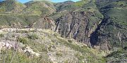
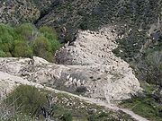
The only visible remains of the St. Francis Dam are weathered, broken chunks of gray concrete and the rusted remnants of the handrails that lined the top of the dam and the wing dike. The ruins and the scar from the paleomegalandslide can be seen from San Francisquito Canyon Road, about five miles (8 km) north of the community of Newhall in Santa ClaritaSanta Clarita, California
Santa Clarita is the fourth largest city in Los Angeles County, California, United States and the twenty-fourth largest city in the state of California. The 2010 US Census reported the city's population grew 16.7% from the year 2000 to 176,320 residents. It is located about northwest of downtown...
.
The road sustained heavy storm damage in 2005 and when rebuilt, it was routed away from both the remains of the dam and the damaged portion of the roadway.
A mass grave for victims of the disaster is at Ivy Lawn Memorial Park, in Ventura
Ventura, California
Ventura is the county seat of Ventura County, California, United States, incorporated in 1866. The population was 106,433 at the 2010 census, up from 100,916 at the 2000 census. Ventura is accessible via U.S...
.
In popular culture
- Robert TowneRobert TowneRobert Towne is an American screenwriter and director. His most notable work may be his Academy Award-winning original screenplay for Roman Polanski's Chinatown .-Film:...
made numerous references to Mulholland, the California Water WarsCalifornia Water WarsThe California Water Wars were a series of conflicts between the city of Los Angeles, farmers and ranchers in the Owens Valley of Eastern California, and environmentalists. As Los Angeles grew in the late 1800s, it started to outgrow its water supply. Fred Eaton, mayor of Los Angeles, realized that...
, the aqueduct, and the St. Francis Dam disaster in his screenplay for the 1974 Neo-noirNeo-noirNeo-noir is a style often seen in modern motion pictures and other forms that prominently utilize elements of film noir, but with updated themes, content, style, visual elements or media that were absent in films noir of the 1940s and 1950s.-History:The term Film Noir was coined by...
movie Chinatown. Mulholland is split between the characters of Noah Cross (John HustonJohn HustonJohn Marcellus Huston was an American film director, screenwriter and actor. He wrote most of the 37 feature films he directed, many of which are today considered classics: The Maltese Falcon , The Treasure of the Sierra Madre , Key Largo , The Asphalt Jungle , The African Queen , Moulin Rouge...
) and the city's chief engineer Hollis Mulwray (Darrell ZwerlingDarrell Zwerling-Filmography:-External links:...
). In one scene, Hollis Mulwray makes a specific reference to the St. Francis Dam disaster, using the fictitious name of "Van der Lip Dam":In case you've forgotten, gentlemen, over five hundred lives were lost when the Van der Lip Dam gave way. Core samples have shown that beneath this bedrock is shale
ShaleShale is a fine-grained, clastic sedimentary rock composed of mud that is a mix of flakes of clay minerals and tiny fragments of other minerals, especially quartz and calcite. The ratio of clay to other minerals is variable. Shale is characterized by breaks along thin laminae or parallel layering...
similar to the permeable shale in the Van der Lip disaster. It couldn't withstand that kind of pressure there. And now you propose yet another dirt-banked terminus dam with slopes of two and one half to one, one hundred twelve feet high and a twelve thousand acre water surface. Well, it won't hold. I won't build it. It's that simple. I am not making that kind of mistake twice. Thank you, gentlemen. - Also in 1974, the movie EarthquakeEarthquake (film)Earthquake is a 1974 American disaster film that achieved huge box-office success, continuing the disaster film genre of the 1970s where recognizable all-star casts attempt to survive life or death situations...
showed the Mulholland Dam meeting a nearly identical demise to that of the St. Francis. - Rock musician Frank BlackFrank BlackBlack Francis is an American singer, songwriter and guitarist. He is best known as the frontman of the influential alternative rock band Pixies, with whom he performs under the stage name Black Francis. Following the band's breakup in 1993, he embarked on a solo career under the name Frank Black...
has made several references to the St. Francis Dam disaster in his songs, including the tracks "St. Francis Dam Disaster" and "Olé Mulholland".
See also
- Baldwin Hills ReservoirBaldwin Hills ReservoirThe Baldwin Hills Reservoir was a water storage basin located on a low hilltop in Baldwin Hills, Los Angeles, California. It was constructed between 1947 and 1951 by the Los Angeles Department of Water and Power directly on an active fault line which was subsidiary to the well known nearby...
- Dam failure
- Malpasset Dam
- Teton DamTeton DamThe Teton Dam was a federally built earthen dam on the Teton River in southeastern Idaho, set between Fremont and Madison counties, USA, which when filling for the first time suffered a catastrophic failure on June 5, 1976. The collapse of the dam resulted in the deaths of 11 peopleand 13,000 head...
- Vajont DamVajont DamThe Vajont Dam is a disused dam, completed in 1959 in the valley of the Vajont river under Monte Toc, 100 km north of Venice, Italy...
External links
dozens of excellent photographs of the dam under construction, completed, its ruins, and a list of the victims.- St. Francis Dam Disaster 30-minute television program available online.
- Remembering the St. Francis Dam Disaster, by Michele E. Buttelman, The Signal March 11, 2001.
- Google Earth image of the St. Francis Dam ruins
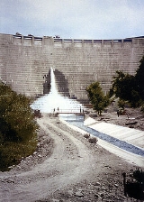
- St. Francis dam ruin on March 12, 1928, looking upstream with onlookers in the foreground. In "Application of the Method of Characteristics to the Dam Break Wave Problem", Journal of Hydraulic Research, 47 (1), pp. 41–49.
- St Francis Dam Flood, image gallery at USGS
- List of victims