
California State Route 126
Encyclopedia
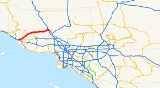
State Route 126 is a highway in Ventura
and Los Angeles
counties, California. The route runs from U.S. Route 101 in Ventura
to Interstate 5 in Santa Clarita
. The highway is a important connector highway in Ventura County
, and serves as an alternate route into the Santa Clarita and San Fernando valleys, the High Desert of Antelope Valley, and Los Angeles.
via Interstate 5. The highway is officially designated as the Korean War Veterans' Memorial Highway. This route is part of the California Freeway and Expressway System
and is eligible for the State Scenic Highway System
. However, it is not a scenic highway as designated by Caltrans.
State Route 126 generally follows the Santa Clara River
through the valley, passing through the towns of Fillmore
and Santa Paula
. The freeway portion of the highway - called the Santa Paula Freeway - begins in Ventura at U.S. Route 101. It proceeds northeast through the city, interchanging with the western end of SR 118 at a grade-separated interchange. SR 126 then passes through the area of agriculture, orchards, and the Saticoy Oil Field
to its northeast, continuing through Santa Paula, where it intersects SR 150, and the freeway portion terminates at Hallock Drive. SR 126 continues as a highway thereafter, known as Telegraph Road. This section extends through Fillmore
as Ventura Street, where SR 126 meets SR 23. Following this, SR 126 as Telegraph Road encounters the community of Buckhorn
, as well as the edge of Piru
and the important historical Rancho Camulos
.
In Los Angleles County, SR 126 is known as Henry Mayo Drive. The highway continues east to Castaic Junction
, where there is an interchange with The Old Road before a second interchange with I-5. At this interchange the SR 126 designation terminates, and the road continues into Santa Clarita
as Newhall Ranch Road.
. In the face of anti-development pressure from Ventura County citizens, and suffering from severe financial problems as a result of the 1971 Sylmar earthquake
and the late-1970s California tax revolt
, Caltrans abandoned these plans. The only remnants of these plans are the two long ramps to and from the Antelope Valley Freeway at the Sierra Highway
exit 6A in Santa Clarita
.
From 1964 until 2002, a second segment of Route 126 ran from I-5 to State Route 14
through Santa Clarita
via Magic Mountain Parkway and what was then called San Fernando Road
(now Railroad Avenue from Magic Mountain Parkway to Main Street, all of Main Street, and Newhall Avenue from Main Street to Route 14); it has since been decommissioned.
Newhall Ranch Road in Santa Clarita
, a six to eight-lane divided local road, continues from the current terminus of SR 126 at Interstate 5
and roughly follows the original 1958 route to just past Bouquet Canyon Road on the north side of the Santa Clara River
. Current plans are for this road to be connected to Golden Valley Road via an eight-lane bridge across the Santa Clara River. This bridge would connect the road directly to SR 14
at the Golden Valley Road exit, 1 mile south of the originally planned SR 126 connector.
On March 27, 2010 the link between SR 126 and SR 14
was completed, making the connection of Newhall Ranch Road/SR 126 with Golden Valley Road/SR 14. The roadway is now a complete 50 mile highway between U.S. 101 and SR 14
with no overlap with Interstate 5 and the longer drive through Santa Clarita. State maintenance ends at Interstate 5 though with the road continuing uninterrupted with 6 lanes to SR 14
.
{| class=wikitable
!County
!Location
!Postmile
!Exit
!Destinations
!Notes
|-
|rowspan=11|Ventura
VEN 0.00-R34.64
|rowspan=5|Ventura
|bgcolor=#ffdddd|0.00
|bgcolor=#ffdddd|1A
|bgcolor=#ffdddd|
|bgcolor=#ffdddd|Westbound exit and eastbound entrance
|-bgcolor=#ffdddd
|0.00
|1B
|Main Street
|Westbound exit and eastbound entrance
|-
|1.45
|1C
|.svg.png) Victoria Avenue to US 101 south (Ventura Freeway
Victoria Avenue to US 101 south (Ventura Freeway
, SR 1
south)
|Signed as exit 1 eastbound
|-
|2.80
|3
|Kimball Road
|
|-
|R5.03
|5
|
|
|-
|
|R8.91
|9
|Briggs Road
|
|-
|rowspan=4|Santa Paula
|R10.38
|10
|Peck Road
|
|-
|R11.37
|11
|Palm Avenue
|
|-
|R12.04
|12
|
|
|-
|colspan=4 align=center|East end of freeway
|-
|Fillmore
|21.14
|
|
|
|-
|rowspan=4|Los Angeles
LA R0.00-R5.83
|
|
|
|Commerce Center Drive, Henry Mayo Drive to The Old Road
|
|-
|
|bgcolor=#ffdddd|R5.46
|bgcolor=#ffdddd|40A
|bgcolor=#ffdddd|Castaic Junction
|bgcolor=#ffdddd|Interchange; eastbound exit only
|-
|rowspan=2|Santa Clarita
|R5.83
|40
|
|Interchange; signed as exits 40B (south) and 40C (north)
|-
|R5.83
|
|Newhall Ranch Road
|Continuation beyond I-5; connects to Golden Valley Road and SR 14
Ventura County, California
Ventura County is a county in the southern part of the U.S. state of California. It is located on California's Pacific coast. It is often referred to as the Gold Coast, and has a reputation of being one of the safest populated places and one of the most affluent places in the country...
and Los Angeles
Los Angeles County, California
Los Angeles County is a county in the U.S. state of California. As of 2010 U.S. Census, the county had a population of 9,818,605, making it the most populous county in the United States. Los Angeles County alone is more populous than 42 individual U.S. states...
counties, California. The route runs from U.S. Route 101 in Ventura
Ventura, California
Ventura is the county seat of Ventura County, California, United States, incorporated in 1866. The population was 106,433 at the 2010 census, up from 100,916 at the 2000 census. Ventura is accessible via U.S...
to Interstate 5 in Santa Clarita
Santa Clarita, California
Santa Clarita is the fourth largest city in Los Angeles County, California, United States and the twenty-fourth largest city in the state of California. The 2010 US Census reported the city's population grew 16.7% from the year 2000 to 176,320 residents. It is located about northwest of downtown...
. The highway is a important connector highway in Ventura County
Ventura County, California
Ventura County is a county in the southern part of the U.S. state of California. It is located on California's Pacific coast. It is often referred to as the Gold Coast, and has a reputation of being one of the safest populated places and one of the most affluent places in the country...
, and serves as an alternate route into the Santa Clarita and San Fernando valleys, the High Desert of Antelope Valley, and Los Angeles.
Route description
State Route 126 is the main route from Ventura County to the San Joaquin ValleySan Joaquin Valley
The San Joaquin Valley is the area of the Central Valley of California that lies south of the Sacramento – San Joaquin River Delta in Stockton...
via Interstate 5. The highway is officially designated as the Korean War Veterans' Memorial Highway. This route is part of the California Freeway and Expressway System
California Freeway and Expressway System
The California Freeway and Expressway System is a system of existing or planned freeways and expressways in the U.S. state of California. It is defined by the Streets and Highways Code.-List of roads in the system:*State Route 1 *State Route 2...
and is eligible for the State Scenic Highway System
State Scenic Highway System (California)
The State Scenic Highway System is a list of highways, mainly state highways, that have been designated by the California Department of Transportation as scenic highways. The California State Legislature, primarily through Section 263 of the Streets and Highways Code, makes highways eligible for...
. However, it is not a scenic highway as designated by Caltrans.
State Route 126 generally follows the Santa Clara River
Santa Clara River (California)
The Santa Clara River is approximately long, located in southern California in the United States. It drains an area of the coastal mountains north of Los Angeles. The Santa Clara is one of the largest river systems along the coast of Southern California and one of only a few remaining river...
through the valley, passing through the towns of Fillmore
Fillmore, California
Fillmore is a city in Ventura County, California, United States. The population was 15,002 at the 2010 census, up from 13,643 at the 2000 census.- History :...
and Santa Paula
Santa Paula, California
Santa Paula is a city within Ventura County, California, United States. The population was 29,321 at the 2010 census, up from 28,598 at the 2000 census...
. The freeway portion of the highway - called the Santa Paula Freeway - begins in Ventura at U.S. Route 101. It proceeds northeast through the city, interchanging with the western end of SR 118 at a grade-separated interchange. SR 126 then passes through the area of agriculture, orchards, and the Saticoy Oil Field
Saticoy Oil Field
The Saticoy Oil Field is an oil and gas field in Ventura County, California, in the United States. The field is a long narrow band paralleling the Santa Clara River near the town of Saticoy. Discovered in 1955, it is one of the smaller but productive fields found in the region after most of the...
to its northeast, continuing through Santa Paula, where it intersects SR 150, and the freeway portion terminates at Hallock Drive. SR 126 continues as a highway thereafter, known as Telegraph Road. This section extends through Fillmore
Fillmore, California
Fillmore is a city in Ventura County, California, United States. The population was 15,002 at the 2010 census, up from 13,643 at the 2000 census.- History :...
as Ventura Street, where SR 126 meets SR 23. Following this, SR 126 as Telegraph Road encounters the community of Buckhorn
Buckhorn, Ventura County, California
Buckhorn is a small unincorporated community in Ventura County, California, United States. The ZIP Code is 93040, and the community is inside area code 805.-Politics:...
, as well as the edge of Piru
Piru, California
Piru is a small unincorporated census-designated town located in eastern Ventura County, California, in the Santa Clara River Valley near the Santa Clara River and Highway 126, about seven miles east of Fillmore and about west of Interstate 5. The population was 2,063 at the 2010 census, up from...
and the important historical Rancho Camulos
Rancho Camulos
Rancho Camulos, now known as Rancho Camulos Museum, is a ranch located in the Santa Clara River Valley east of Piru, California and just north of the Santa Clara River, in present day Ventura County, California. It was the home of Ygnacio del Valle, an alcalde of the Pueblo de Los Angeles and...
.
In Los Angleles County, SR 126 is known as Henry Mayo Drive. The highway continues east to Castaic Junction
Castaic Junction, California
Castaic Junction is an unincorporated community located in Los Angeles County, California. It is located at the junction of Interstate 5 and State Route 126, and was the official southern end of the Ridge Route.-References:...
, where there is an interchange with The Old Road before a second interchange with I-5. At this interchange the SR 126 designation terminates, and the road continues into Santa Clarita
Santa Clarita, California
Santa Clarita is the fourth largest city in Los Angeles County, California, United States and the twenty-fourth largest city in the state of California. The 2010 US Census reported the city's population grew 16.7% from the year 2000 to 176,320 residents. It is located about northwest of downtown...
as Newhall Ranch Road.
History
In the late 1950s, the freeway was originally planned to continue all the way to the Antelope Valley Freeway in what is now Santa ClaritaSanta Clarita, California
Santa Clarita is the fourth largest city in Los Angeles County, California, United States and the twenty-fourth largest city in the state of California. The 2010 US Census reported the city's population grew 16.7% from the year 2000 to 176,320 residents. It is located about northwest of downtown...
. In the face of anti-development pressure from Ventura County citizens, and suffering from severe financial problems as a result of the 1971 Sylmar earthquake
Sylmar earthquake
The 1971 San Fernando earthquake struck the San Fernando Valley near Sylmar, California at 6:00:55 a.m. PST on February 9, 1971, with a magnitude of 6.6....
and the late-1970s California tax revolt
Tax revolt
A tax revolt is a political struggle to repeal, limit, or roll back a tax.-1930s, The Great Depression:In the United States, the term "tax revolt" is sometimes used to refer to a series of anti-tax state initiative campaigns. The first significant wave of these campaigns was during the 1930s. The...
, Caltrans abandoned these plans. The only remnants of these plans are the two long ramps to and from the Antelope Valley Freeway at the Sierra Highway
Sierra Highway
Sierra Highway or El Camino Sierra is a road in Southern California, United States. El Camino Sierra refers to the full length of a trail formed in the 19th century, rebuilt as highways in the early 20th century, that ran from Los Angeles to Lake Tahoe following parts of modern State Route 14, U.S....
exit 6A in Santa Clarita
Santa Clarita, California
Santa Clarita is the fourth largest city in Los Angeles County, California, United States and the twenty-fourth largest city in the state of California. The 2010 US Census reported the city's population grew 16.7% from the year 2000 to 176,320 residents. It is located about northwest of downtown...
.
From 1964 until 2002, a second segment of Route 126 ran from I-5 to State Route 14
California State Route 14
State Route 14 is a north–south state highway in the U.S. state of California, largely in the Mojave Desert. The southern portion of the highway is signed as the Antelope Valley Freeway. The route connects Interstate 5, or Golden State Freeway, near Santa Clarita and with U.S. Route 395 near...
through Santa Clarita
Santa Clarita, California
Santa Clarita is the fourth largest city in Los Angeles County, California, United States and the twenty-fourth largest city in the state of California. The 2010 US Census reported the city's population grew 16.7% from the year 2000 to 176,320 residents. It is located about northwest of downtown...
via Magic Mountain Parkway and what was then called San Fernando Road
San Fernando Road
San Fernando Road is a major street in the city and county of Los Angeles. It starts off in Castaic as The Old Road, passing through Santa Clarita and the Newhall Pass, whereupon its intersection with Sierra Highway near the junction of the Golden State and the Antelope Valley Freeways, it...
(now Railroad Avenue from Magic Mountain Parkway to Main Street, all of Main Street, and Newhall Avenue from Main Street to Route 14); it has since been decommissioned.
Newhall Ranch Road in Santa Clarita
Santa Clarita, California
Santa Clarita is the fourth largest city in Los Angeles County, California, United States and the twenty-fourth largest city in the state of California. The 2010 US Census reported the city's population grew 16.7% from the year 2000 to 176,320 residents. It is located about northwest of downtown...
, a six to eight-lane divided local road, continues from the current terminus of SR 126 at Interstate 5
Interstate 5 in California
Interstate 5 is a major north–south route of the Interstate Highway System in the U.S. state of California. It begins at the Mexico – United States border at the San Ysidro crossing, goes north across the length of California and crosses into Oregon south of the Medford-Ashland metropolitan...
and roughly follows the original 1958 route to just past Bouquet Canyon Road on the north side of the Santa Clara River
Santa Clara River (California)
The Santa Clara River is approximately long, located in southern California in the United States. It drains an area of the coastal mountains north of Los Angeles. The Santa Clara is one of the largest river systems along the coast of Southern California and one of only a few remaining river...
. Current plans are for this road to be connected to Golden Valley Road via an eight-lane bridge across the Santa Clara River. This bridge would connect the road directly to SR 14
California State Route 14
State Route 14 is a north–south state highway in the U.S. state of California, largely in the Mojave Desert. The southern portion of the highway is signed as the Antelope Valley Freeway. The route connects Interstate 5, or Golden State Freeway, near Santa Clarita and with U.S. Route 395 near...
at the Golden Valley Road exit, 1 mile south of the originally planned SR 126 connector.
On March 27, 2010 the link between SR 126 and SR 14
California State Route 14
State Route 14 is a north–south state highway in the U.S. state of California, largely in the Mojave Desert. The southern portion of the highway is signed as the Antelope Valley Freeway. The route connects Interstate 5, or Golden State Freeway, near Santa Clarita and with U.S. Route 395 near...
was completed, making the connection of Newhall Ranch Road/SR 126 with Golden Valley Road/SR 14. The roadway is now a complete 50 mile highway between U.S. 101 and SR 14
California State Route 14
State Route 14 is a north–south state highway in the U.S. state of California, largely in the Mojave Desert. The southern portion of the highway is signed as the Antelope Valley Freeway. The route connects Interstate 5, or Golden State Freeway, near Santa Clarita and with U.S. Route 395 near...
with no overlap with Interstate 5 and the longer drive through Santa Clarita. State maintenance ends at Interstate 5 though with the road continuing uninterrupted with 6 lanes to SR 14
California State Route 14
State Route 14 is a north–south state highway in the U.S. state of California, largely in the Mojave Desert. The southern portion of the highway is signed as the Antelope Valley Freeway. The route connects Interstate 5, or Golden State Freeway, near Santa Clarita and with U.S. Route 395 near...
.
Major intersections
- Note: Except where prefixed with a letter, postmiles were measured in 1964, based on the alignment as it existed at that time, and do not necessarily reflect current mileage. The numbers reset at county lines; the start and end postmiles in each county are given in the county column.
{| class=wikitable
!County
!Location
!Postmile
!Exit
Exit number
An exit number is a number assigned to a road junction, usually an exit from a freeway. It is usually marked on the same sign as the destinations of the exit, as well as a sign in the gore....
!Destinations
!Notes
|-
|rowspan=11|Ventura
Ventura County, California
Ventura County is a county in the southern part of the U.S. state of California. It is located on California's Pacific coast. It is often referred to as the Gold Coast, and has a reputation of being one of the safest populated places and one of the most affluent places in the country...
VEN 0.00-R34.64
|rowspan=5|Ventura
Ventura, California
Ventura is the county seat of Ventura County, California, United States, incorporated in 1866. The population was 106,433 at the 2010 census, up from 100,916 at the 2000 census. Ventura is accessible via U.S...
|bgcolor=#ffdddd|0.00
|bgcolor=#ffdddd|1A
|bgcolor=#ffdddd|
|bgcolor=#ffdddd|Westbound exit and eastbound entrance
|-bgcolor=#ffdddd
|0.00
|1B
|Main Street
|Westbound exit and eastbound entrance
|-
|1.45
|1C
|
Ventura Freeway
The Ventura Freeway is a freeway in southern California running from Ventura to Pasadena. It is the principal east-west route through Ventura County and in the southern San Fernando Valley in Los Angeles County. From Ventura to its intersection with the Hollywood Freeway in the southeastern San...
, SR 1
California State Route 1
State Route 1 , more often called Highway 1, is a state highway that runs along much of the Pacific coast of the U.S. state of California. It is famous for running along some of the most beautiful coastlines in the world, leading to its designation as an All-American Road.Highway 1 does not run...
south)
|Signed as exit 1 eastbound
|-
|2.80
|3
|Kimball Road
|
|-
|R5.03
|5
|
|
|-
|
|R8.91
|9
|Briggs Road
|
|-
|rowspan=4|Santa Paula
Santa Paula, California
Santa Paula is a city within Ventura County, California, United States. The population was 29,321 at the 2010 census, up from 28,598 at the 2000 census...
|R10.38
|10
|Peck Road
|
|-
|R11.37
|11
|Palm Avenue
|
|-
|R12.04
|12
|
|
|-
|colspan=4 align=center|East end of freeway
|-
|Fillmore
Fillmore, California
Fillmore is a city in Ventura County, California, United States. The population was 15,002 at the 2010 census, up from 13,643 at the 2000 census.- History :...
|21.14
|
|
|
|-
|rowspan=4|Los Angeles
Los Angeles County, California
Los Angeles County is a county in the U.S. state of California. As of 2010 U.S. Census, the county had a population of 9,818,605, making it the most populous county in the United States. Los Angeles County alone is more populous than 42 individual U.S. states...
LA R0.00-R5.83
|
|
|
|Commerce Center Drive, Henry Mayo Drive to The Old Road
|
|-
|
|bgcolor=#ffdddd|R5.46
|bgcolor=#ffdddd|40A
|bgcolor=#ffdddd|Castaic Junction
Castaic Junction, California
Castaic Junction is an unincorporated community located in Los Angeles County, California. It is located at the junction of Interstate 5 and State Route 126, and was the official southern end of the Ridge Route.-References:...
|bgcolor=#ffdddd|Interchange; eastbound exit only
|-
|rowspan=2|Santa Clarita
Santa Clarita, California
Santa Clarita is the fourth largest city in Los Angeles County, California, United States and the twenty-fourth largest city in the state of California. The 2010 US Census reported the city's population grew 16.7% from the year 2000 to 176,320 residents. It is located about northwest of downtown...
|R5.83
|40
|
|Interchange; signed as exits 40B (south) and 40C (north)
|-
|R5.83
|
|Newhall Ranch Road
|Continuation beyond I-5; connects to Golden Valley Road and SR 14
California State Route 14
State Route 14 is a north–south state highway in the U.S. state of California, largely in the Mojave Desert. The southern portion of the highway is signed as the Antelope Valley Freeway. The route connects Interstate 5, or Golden State Freeway, near Santa Clarita and with U.S. Route 395 near...