

Transportation of Los Angeles
Encyclopedia
The intercity transportation system in Los Angeles
serves as a regional, national and international hub for passenger and freight traffic. The system includes the United States' largest port complex, an extensive freight and passenger rail infrastructure, numerous airports and an extensive highway system. The city also has a busy intracity transportation system composed of numerous freeways, road
s, bus
lines, light rail
lines, and subway
lines.
The primary Los Angeles airport is Los Angeles International Airport (LAX)
. The fifth busiest commercial airport in the world and the third busiest in the United States
, LAX handled 61.9 million passengers, 1.884 million metric tons of cargo and 680,954 aircraft movements in 2007.
Other major nearby commercial airports include: LA/Ontario International Airport (serves the Inland Empire); Bob Hope Airport
(formerly known as Burbank Airport; serves the San Fernando and San Gabriel Valleys); Long Beach Airport (serves the Long Beach/Harbor area); John Wayne Airport
(serves the Orange County area); LA/Palmdale Regional Airport (serves the northern outlying communities of the Santa Clarita
and Antelope Valley
s although has little passenger traffic).
The world's busiest general-aviation airport is also located in Los Angeles, Van Nuys Airport
.
 L.A.'s Union Station
is the major regional train station
for Amtrak
, Metrolink
and Metro Rail
. The station is Amtrak's fifth busiest station having 1,464,289 Amtrak boardings and deboardings in 2006. Amtrak operates eleven daily round trips between San Diego and Los Angeles, five of which continue to Santa Barbara
via the Pacific Surfliner
, the only service that runs through Los Angeles
multiple times daily. Two of those trips continue to San Luis Obispo. The Coast Starlight
provides additional service on the route and beyond to the San Francisco Bay Area
, Sacramento, and on to Seattle. Amtrak motor coaches connect from Los Angeles to the San Joaquin Route in Bakersfield with frequent service through the Central Valley of California to Sacramento
, and Oakland
. There is also daily service to Chicago
on the Southwest Chief
, and three times a week to New Orleans on the Sunset Limited
. Due to the effects from Hurricane Katrina
, Sunset Limited service east of New Orleans to Jacksonville, Florida
has been discontinued, although Amtrak is required by current Federal Law to develop a plan to reinstate the service. The Texas Eagle
is a second train to Chicago
that has service three time a week. Between Los Angeles
, and San Antonio
, the Sunset Limited
and Texas Eagle
run together, and then the train is split. Sunset Limited
to New Orleans, and Texas Eagle
to Chicago
.
Amtrak Pacific Surfliner
trains stop at several locations in Los Angeles County, including Glendale
, Bob Hope Airport in Burbank
, Chatsworth
, and Van Nuys. Van Nuys Station in the community of Van Nuys serves northern portions of Los Angeles.
Because of the large volumes of import freight that flows into the city's port complex, Los Angeles is a major freight railroad hub. Freight is hauled by Union Pacific Railroad
and BNSF Railway
. The now-defunct Southern Pacific Railroad
once served the Los Angeles area before merging with Union Pacific. The Alameda Corridor
, a below-grade rail corridor connects the port to the city's main rail yards and to points further north and east.
and south to San Diego
), Interstate 15 (north to Las Vegas
and south to San Diego), U.S. Route 101 (north to Santa Barbara
), and Interstate 10 (east to Phoenix
).
operates several stations within the city of Los Angeles:
Greyhound Lines operates stations in the following cities and areas surrounding Los Angeles:
Greyhound Lines also services bus stops at:
 The Port of Los Angeles
is located in San Pedro Bay
in the San Pedro
neighborhood, approximately 20 miles (30 km) south of Downtown
. Also called Los Angeles Harbor and WORLDPORT L.A., the port complex occupies 7,500 acres (30 km²) of land and water along 43 miles (69 km) of waterfront. It adjoins the separate Port of Long Beach
.
The sea ports of the Port of Los Angeles
and Port of Long Beach
together make up the Los Angeles – Long Beach Harbor. There are also smaller, non-industrial harbors along L.A.'s coastline. Most of these like Redondo Beach
and Marina del Rey
are used primarily by sailboat
s and yacht
s.
The Port of Los Angeles
along with the Port of Long Beach
comprise the largest seaport complex in the United States
and the fifth busiest in the world. Over 11 percent of United States international trade (by value) passes through the Los Angeles region and it the Los Angeles customs district collects over 37 percent of the nation’s import duties.
The port includes four bridges: the Vincent Thomas Bridge
, Henry Ford Bridge
, Gerald Desmond Bridge
, and Commodore Schuyler F. Heim Bridge.
; they are mainly used for day excursions and to move supplies to Catalina Island
. There is no regular vehicle ferry service to Avalon, however, since the city restricts the use of cars and trucks within its borders.

 The City of Los Angeles is served by a large network of freeways, streets, and local and regional public transportation systems.
Major freeways of Los Angeles include:
Major highways of Los Angeles include:
Angelenos are noted for referring to freeways with the definite article ("The 101"), in contrast to most other areas of the United States, who omit the article. Referring to freeways by name, for example "The San Diego Freeway", is essentially a holdover from the time when the freeways were built, and is diminishing. Nevertheless, freeways continue to be officially named, and the 118 was recently christened The Ronald Reagan Freeway.
occurs on weekdays between 5 a.m. and 10 a.m., and in the afternoon between 3 p.m. and 7 p.m (although rush-hour traffic can occasionally spill out to 11am and start again from 2:30pm until as late as 9pm, especially on Fridays). Traffic can occur at almost any time, particularly before major holidays (including Thanksgiving
, Christmas
, and three-day weekends) and even on regular weekends when one otherwise would not expect it. Experienced Angelenos know that they need to factor traffic into their commute. A major selling point for the two news radio stations in Los Angeles is their frequent traffic reports.
Despite the congestion in the city, the mean travel time for commuters in Los Angeles is shorter than other major cities, including New York City
, Philadelphia and Chicago
. Los Angeles' mean travel time for work commutes in 2006 was 29.2 minutes, similar to those of San Francisco and Washington, DC.
(referred to as surface streets by locals, in contrast with freeways which are usually grade-separated roadways) connect freeways with smaller neighborhood streets, and are often used to bypass congested freeway routes. Consequently, most of the surface arterial streets in Los Angeles have various forms of congestion control.
Some of the more common means of maintaining surface street traffic flow is the use of loop-sensors embedded in the pavement allowing for intersection traffic signal timing adjustments to favor the more heavily delayed roadways; the use of a "smart-grid" traffic control system which allows for the synchronization of traffic signals to improve traffic flow (as of October 2009 this system is currently installed at 85% of the city's signalized intersections, more than any other US city); restrictions on vehicle turns on roadways without designated turning lanes during rush-hours; and the extensive use of rush-hour parking restrictions, allowing for an extra lane of travel in each direction during peak hours (weekdays excluding holidays generally from 7-9am thru 4-7pm, although hours vary by location) by eliminating on street parking and standing of vehicles, with violators being ticketed, and in the case of priority routes known as "anti-gridlock zones", immediately towed by specialized enforcement teams dubbed "tiger teams" at steep cost to the violator.
1st Street divides the block numbering grid north and south, and southwest of the Los Angeles River, Main Street divides the city east and west. Northeast of the river, block designations are divided east and west by Pasadena Avenue and N Figueroa Street.
From downtown Los Angeles to Long Beach, in a straight-down vertical pattern, east–west streets are numbered (starting with 1st Street in downtown, to 266th Street in Harbor City
), and north–south streets are named. (1st St. is one block south of Temple.) There are many exceptions to the numbered streets, but the above pattern is generally used. This same numbered pattern is not mirrored north of Temple. Addresses are then numbered East or West stemming from Main St (a major north south artery). Therefore, the landmark Watts Towers at 1765 E. 107th St. is approximately 107 streets south of 1st Street, and on the 17th street east of Main St. Although the numbered streets are sequential, they do not necessarily equal the number of blocks south of first street, as there are streets such as 118th St. and then 118th Place.
Many of the numbered streets also continue into neighboring cities; but some cities, such as Manhattan Beach, have made their own numbered street grid. Also, some districts of Los Angeles, such as Wilmington, San Pedro, and Venice, have their own numbered street grids.
Many arterials have been labeled as boulevard
s, and many of those mentioned below have been immortalized in movies, music, and literature.
Major east–west routes include: Victory
, Ventura
, Hollywood
, Sunset
, Santa Monica, Beverly
, Wilshire
, Olympic
, Pico
, Venice, Washington
, Adams, Jefferson
, Exposition and Martin Luther King. The major north–south routes include: Topanga Canyon, Reseda
, Lincoln, Sepulveda
, Van Nuys
, Westwood
, Beverly Glen
, San Vicente
, Robertson
, La Cienega
, Laurel Canyon
, Crenshaw, Glendale
, and Avalon
.
There are many other famous L.A. streets which carry significant traffic but are not labeled as boulevards. Examples include: Broadway
, Bundy Drive, Barrington Avenue, Centinela Avenue
, Mulholland Drive
, Pacific Coast Highway, Slauson Avenue
, Century Park East, Avenue of the Stars, Highland Avenue, Melrose Avenue
, Florence Avenue
, Normandie Avenue
, Vermont Avenue
, La Brea Avenue
, Fairfax Avenue
, Western Avenue
, Figueroa Street
, Grand Avenue
, Huntington Drive
, Central Avenue, and Alameda Street. West Los Angeles has many streets named after states that run east and west. Somewhat confusingly, adjacent Santa Monica uses a few of the same state names for different streets of its own.
Pothole
s are a notorious problem in Los Angeles and frequently cause severe damage to all kinds of vehicles. Mayor Antonio Villaraigosa
made "Operation Pothole" one of his top priorities in 2008 and pledged to fill 1 million potholes. However, due to the city's poorly managed budget, the city's Bureau of Street Services has only a single dedicated pothole-repair truck to cover 275 miles of streets (meaning that the backlog is still bad and getting worse). Many city streets, such as Wilshire Boulevard
, were engineered when cars, trucks, and buses were much smaller, and desperately need to be torn up and rebuilt from scratch to handle the weight of today's larger vehicles.
Furthermore, due to its severe budget problems, Los Angeles is one of the few California cities that does not use raised pavement marker
s on its streets. Thus, Los Angeles drivers must be vigilant not only for potholes, but for other drivers drifting out of lanes due to the lack of tactile feedback normally provided by such markers.
 Despite the assertion of the popular song that "nobody walks in L.A."
, 3.4% of Los Angeles residents commute to work by walking and Los Angeles residents walk for exercise at rates similar to those of other major U.S. cities.
There are a number of commercial areas that have been redeveloped in the past two decades specifically to accommodate pedestrian
traffic. Old Town Pasadena
was redeveloped in the late 1980s by moving parking off Colorado Boulevard
so as to make the street pedestrian-focused. Likewise, the Third Street Promenade
in Santa Monica
was closed off to vehicular traffic altogether in 1965 and revitalized with improved pedestrian amenities in 1988. Downtown Los Angeles
has numerous public escalator
s and skyway
s, such as the Bunker Hill
steps to facilitate pedestrian traffic in the traffic-laden and hilly terrain.
Downtown Los Angeles is one of two neighborhoods in Los Angeles ranked as a "walker's paradise" (with walk scores 90 or above) by WalkScore.com
. The other is Mid-City West, which encompasses the area of the city immediately south of West Hollywood and east of Beverly Hills.
Nevertheless, much of Los Angeles remains pedestrian unfriendly. A large percentage of sidewalk
s in the City of Los Angeles (43% or 4600 miles (7,403 km) of the 10,600 total miles) are in ill repair stemming from the City Council
passing an ordinance in 1973 that relieved property owners of responsibility for repair of sidewalks damaged by root
s, while failing to concurrently allocate funds for city repairs of such sidewalks. The city began dedicating funds for sidewalk repairs in 2000, but the backlog created by the twenty-six year repair hiatus is severe.
 The primary regional public transport
ation agency is the Los Angeles County Metropolitan Transportation Authority
(LACMTA), commonly referred to as Metro or MTA. The agency, which operates bus, light rail and subway services, averages 1.6 million transit trips per weekday, making it the third largest transit agency in the United States. Other municipal transportation agencies in Los Angeles County (LADOT, Long Beach Transit
, Montebello Bus Lines
, Norwalk Transit
, Redondo Beach, Santa Monica
's Big Blue Bus
, Santa Clarita Transit
, Torrance Transit
and Foothill Transit
) have an additional 405,000 average weekday boardings.
In February 2008, LACMTA introduced a new universal fare system called 'TAP' which stands for Transit Access Pass
. The TAP smart card allows bus and rail passengers to tap their cards on the farebox for faster boarding. TAP readers have already been installed on buses and rail stations next to ticket vending machines. Because Metro Rail
is a barrier free system, fare inspectors will be checking to make sure TAP users have validated their card using a wireless handheld unit. This automated fare system will eventually be implemented on eleven other Los Angeles County transit operators and intends to replace the EZ Pass which allows travel between these transit agencies for one monthly price. Commuters from surrounding cities and communities will be able to travel across the county switching from one transit operator's system to another using one smart card to pay for fares.
, Metro Rapid
, and Metro Express
services. Local buses tend to be orange, while rapid and express buses are red. Rapid bus route numbers usually begin with a 7 and express bus numbers begin with a 9. The buses have an estimated 1.3 million boardings on the weekdays. Including other municipal bus operators, Los Angeles County averages 1.7 million bus boardings per weekday, accounting for approximately 5.9% of the 29 million daily trips originating in Los Angeles County.
LACMTA has two bus rapid transit
lines: the Orange Line and the Silver Line. The Orange Line runs from Warner Center/Woodland Hills to the North Hollywood
Red Line station, began operations on October 29, 2005. For 13 of its 14 miles (22.5 km) stretch (21 km of its 22.5 km stretch), the 60 feet (18.3 m) articulated buses, built by North American Bus Industries
and dubbed Metro Liners, operate on bus-only lanes that follow an old railroad right-of-way
. Portions of the route parallel Chandler and Victory Boulevards, and Oxnard Street.
The new silver line travels 26 miles between El Monte Station in El Monte and the Artesia Transit Center
near Carson.
Foothill Transit also operates a bus rapid transit system called the Silver Streak
, which runs from Montclair
to Downtown Los Angeles
along the El Monte Busway
on Interstate 10.
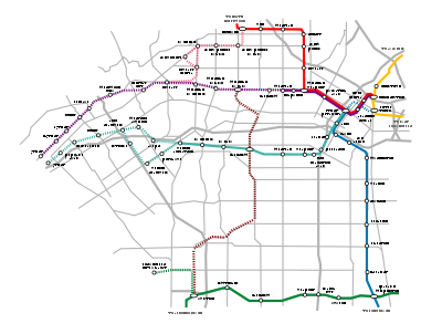 Between its light rail
and heavy rail systems, Los Angeles Metro Rail has 73 miles (117.5 km) of rail, averaging 308,653 trips per weekday, and accounting for approximately 1.1% of the 29 million daily trips originating in Los Angeles County. The network includes three above-ground light rail
lines (Gold Line, Blue Line, and Green Line) and one underground subway
with two branches (Red Line and Purple Line). Ranked by daily ridership, the Los Angeles subway ranked as the ninth-busiest rapid transit system in the United States. Ranked by passengers per route mile, however, the system ranks sixth, transporting 8,846 passengers per route mile, more than San Francisco's Bay Area Rapid Transit
or the Chicago 'L'
.
The Los Angeles Metro Rail system connects disperse areas of the county including Long Beach
, Pasadena
, Norwalk
, El Segundo
, North Hollywood and Downtown Los Angeles
. The Expo Line's first phase from Downtown Los Angeles to Culver City is set to open in late 2011. In June 2010, construction extending the Gold Line from Pasadena to Azusa is expected to begin. Construction on the Expo Line's extension to Santa Monica is also expected to start later this year. There are several additional rail expansion projects currently under study. The timing of their construction will depend on the availability of funding. These projects include:
, a regional commuter rail service. Metrolink averages 42,600 trips per weekday.
, which runs from Burbank to Long Beach, with only a brief hiatus through downtown.
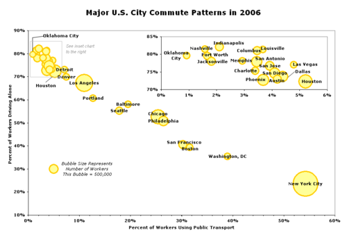 In 2006, of the 4,423,725 workers aged 16 or older in Los Angeles County, 72.0% commuted to work driving
alone, 11.9% commuted by driving in a carpool
and 7.0% commuted on public transport
ation. 64.9% of public transportation commuters were non-white, 70.2% were Hispanic
and 67.6% were foreign born. 75.5% of public transportation commuters earned less than $25,000. However, only 32.7% of public transportation commuters had no vehicle
available to them for their commute.
In the same year, for the City of Los Angeles, of the 1,721,778 workers aged 16 or older, 63.3% commuted to work driving alone, 11.5% commuted by driving in a carpool and 11.0% commuted by public transportation. The percentage of population using public transport in Los Angeles is lower than other large U.S. cities such as Chicago
and New York
, but similar to or higher than other western U.S. cities such as Portland
and Denver. 63.8% of public transportation commuters in the City of Los Angeles in 2006 were non-white, 75.1% were Hispanic and 73.9% were foreign born. 79.4% of public transportation commuters earned less than $25,000 and 37.6% had no vehicle available to them for their commute.
which is about the same size and seismic zone as LA County, has multiple inter/intra-city hubs like Shinjuku and Ueno
which allows ease of commuting to various regions throughout its metropolitan area. The only major hub for Los Angeles is downtown and Union Station, while leaving the entire Westside, LAX, South Bay without any hubs of their own.
Despite LAX being one of the largest airports in the world by passenger volume, LAX lacks a direct rail connection to terminals, though funding has been identified for an extension of the Green Line light rail to the airport using sales tax monies. There are no plans for a direct air-to-rail transfer station for the California High Speed Rail to alleviate any of the commuter jet problems linking LAX to outlying areas such as San Diego, San Bernardino, Santa Barbara, and Fresno.
Los Ángeles
Los Ángeles is the capital of the province of Biobío, in the commune of the same name, in Region VIII , in the center-south of Chile. It is located between the Laja and Biobío rivers. The population is 123,445 inhabitants...
serves as a regional, national and international hub for passenger and freight traffic. The system includes the United States' largest port complex, an extensive freight and passenger rail infrastructure, numerous airports and an extensive highway system. The city also has a busy intracity transportation system composed of numerous freeways, road
Road
A road is a thoroughfare, route, or way on land between two places, which typically has been paved or otherwise improved to allow travel by some conveyance, including a horse, cart, or motor vehicle. Roads consist of one, or sometimes two, roadways each with one or more lanes and also any...
s, bus
Bus
A bus is a road vehicle designed to carry passengers. Buses can have a capacity as high as 300 passengers. The most common type of bus is the single-decker bus, with larger loads carried by double-decker buses and articulated buses, and smaller loads carried by midibuses and minibuses; coaches are...
lines, light rail
Light rail
Light rail or light rail transit is a form of urban rail public transportation that generally has a lower capacity and lower speed than heavy rail and metro systems, but higher capacity and higher speed than traditional street-running tram systems...
lines, and subway
Rapid transit
A rapid transit, underground, subway, elevated railway, metro or metropolitan railway system is an electric passenger railway in an urban area with a high capacity and frequency, and grade separation from other traffic. Rapid transit systems are typically located either in underground tunnels or on...
lines.
Air transportation
In the Los Angeles metropolitan area there are six commercial airports and many more general-aviation airports.The primary Los Angeles airport is Los Angeles International Airport (LAX)
Los Angeles International Airport
Los Angeles International Airport is the primary airport serving the Greater Los Angeles Area, the second-most populated metropolitan area in the United States. It is most often referred to by its IATA airport code LAX, with the letters pronounced individually...
. The fifth busiest commercial airport in the world and the third busiest in the United States
United States
The United States of America is a federal constitutional republic comprising fifty states and a federal district...
, LAX handled 61.9 million passengers, 1.884 million metric tons of cargo and 680,954 aircraft movements in 2007.
Other major nearby commercial airports include: LA/Ontario International Airport (serves the Inland Empire); Bob Hope Airport
Bob Hope Airport
Bob Hope Airport is a public airport located 3 miles northwest of the central business district of Burbank, a city in Los Angeles County, California, United States...
(formerly known as Burbank Airport; serves the San Fernando and San Gabriel Valleys); Long Beach Airport (serves the Long Beach/Harbor area); John Wayne Airport
John Wayne Airport
John Wayne Airport is an airport in an unincorporated area in Orange County, California, with its mailing address in the city of Santa Ana, which is also the county seat, hence the International Air Transport Association airport code. The main entrance to the airport is off of MacArthur Blvd in...
(serves the Orange County area); LA/Palmdale Regional Airport (serves the northern outlying communities of the Santa Clarita
Santa Clarita Valley
The Santa Clarita Valley is the valley of the Santa Clara River in Southern California. It stretches through Los Angeles County and Ventura County. Its main population center is the city of Santa Clarita. The valley was part of the Rancho San Francisco Mexican land grant...
and Antelope Valley
Antelope Valley
The Antelope Valley in California, United States, is located in northern Los Angeles County and the southeastern portion of Kern County, California, and constitutes the western tip of the Mojave Desert...
s although has little passenger traffic).
The world's busiest general-aviation airport is also located in Los Angeles, Van Nuys Airport
Van Nuys Airport
Van Nuys Airport is a public airport located in Van Nuys in the San Fernando Valley section of the city limits of Los Angeles, California, United States. No major commercial airlines fly into this airport; it is used by private, chartered, and small commercial aircraft...
.
Intercity train services
Union Station (Los Angeles)
Los Angeles Union Station is the main railway station in Los Angeles, California. The station has rail services by Amtrak and Amtrak California and Metrolink; light rail/subways are the Metro Rail Red Line, Purple Line, Gold Line. Bus rapid transport runs on the Silver Line...
is the major regional train station
Train station
A train station, also called a railroad station or railway station and often shortened to just station,"Station" is commonly understood to mean "train station" unless otherwise qualified. This is evident from dictionary entries e.g...
for Amtrak
Amtrak
The National Railroad Passenger Corporation, doing business as Amtrak , is a government-owned corporation that was organized on May 1, 1971, to provide intercity passenger train service in the United States. "Amtrak" is a portmanteau of the words "America" and "track". It is headquartered at Union...
, Metrolink
Metrolink (Southern California)
Metrolink is a commuter rail system serving Los Angeles and the surrounding area of Southern California; it currently consists of six lines and 55 stations using of track....
and Metro Rail
Los Angeles County Metro Rail
Metro Rail is the rapid transit rail system consisting of five separate lines serving 70 stations in the Los Angeles County, California area. The new Expo line is due to enter service in early 2012. It connects with the Metro liner bus rapid transit system and also with the Metrolink commuter...
. The station is Amtrak's fifth busiest station having 1,464,289 Amtrak boardings and deboardings in 2006. Amtrak operates eleven daily round trips between San Diego and Los Angeles, five of which continue to Santa Barbara
Santa Barbara, California
Santa Barbara is the county seat of Santa Barbara County, California, United States. Situated on an east-west trending section of coastline, the longest such section on the West Coast of the United States, the city lies between the steeply-rising Santa Ynez Mountains and the Pacific Ocean...
via the Pacific Surfliner
Pacific Surfliner
The Pacific Surfliner is a Amtrak regional passenger train route serving communities on the coast of Southern California between San Diego and San Luis Obispo....
, the only service that runs through Los Angeles
Los Ángeles
Los Ángeles is the capital of the province of Biobío, in the commune of the same name, in Region VIII , in the center-south of Chile. It is located between the Laja and Biobío rivers. The population is 123,445 inhabitants...
multiple times daily. Two of those trips continue to San Luis Obispo. The Coast Starlight
Coast Starlight
The Coast Starlight is a passenger train operated by Amtrak on the West Coast of the United States. It runs from King Street Station in Seattle, Washington, to Union Station in Los Angeles, California. The train's name was formed as a merging of two of Southern Pacific's train names, the Coast...
provides additional service on the route and beyond to the San Francisco Bay Area
San Francisco Bay Area
The San Francisco Bay Area, commonly known as the Bay Area, is a populated region that surrounds the San Francisco and San Pablo estuaries in Northern California. The region encompasses metropolitan areas of San Francisco, Oakland, and San Jose, along with smaller urban and rural areas...
, Sacramento, and on to Seattle. Amtrak motor coaches connect from Los Angeles to the San Joaquin Route in Bakersfield with frequent service through the Central Valley of California to Sacramento
Sacramento, California
Sacramento is the capital city of the U.S. state of California and the county seat of Sacramento County. It is located at the confluence of the Sacramento River and the American River in the northern portion of California's expansive Central Valley. With a population of 466,488 at the 2010 census,...
, and Oakland
Oakland, California
Oakland is a major West Coast port city on San Francisco Bay in the U.S. state of California. It is the eighth-largest city in the state with a 2010 population of 390,724...
. There is also daily service to Chicago
Chicago
Chicago is the largest city in the US state of Illinois. With nearly 2.7 million residents, it is the most populous city in the Midwestern United States and the third most populous in the US, after New York City and Los Angeles...
on the Southwest Chief
Southwest Chief
The Southwest Chief is a passenger train operated by Amtrak on a 2256-mile BNSF route through the Midwestern and Southwestern United States. It runs from Chicago, Illinois, to Los Angeles, California, passing through Illinois, Iowa, Missouri, Kansas, Colorado, New Mexico, Arizona, and California...
, and three times a week to New Orleans on the Sunset Limited
Sunset Limited
The Sunset Limited is a passenger train that for most of its history has run between New Orleans, Louisiana and Los Angeles, California, and that from early 1993 through late August 2005 also ran east of New Orleans to Jacksonville, Florida, making it during that time the only true transcontinental...
. Due to the effects from Hurricane Katrina
Hurricane Katrina
Hurricane Katrina of the 2005 Atlantic hurricane season was a powerful Atlantic hurricane. It is the costliest natural disaster, as well as one of the five deadliest hurricanes, in the history of the United States. Among recorded Atlantic hurricanes, it was the sixth strongest overall...
, Sunset Limited service east of New Orleans to Jacksonville, Florida
Jacksonville, Florida
Jacksonville is the largest city in the U.S. state of Florida in terms of both population and land area, and the largest city by area in the contiguous United States. It is the county seat of Duval County, with which the city government consolidated in 1968...
has been discontinued, although Amtrak is required by current Federal Law to develop a plan to reinstate the service. The Texas Eagle
Texas Eagle
The Texas Eagle is a 1306-mile passenger train route operated by Amtrak in the central and western United States. Trains run daily between Chicago, Illinois, and San Antonio, Texas, and continue to Los Angeles, California, 2728 miles total, three days a week...
is a second train to Chicago
Chicago
Chicago is the largest city in the US state of Illinois. With nearly 2.7 million residents, it is the most populous city in the Midwestern United States and the third most populous in the US, after New York City and Los Angeles...
that has service three time a week. Between Los Angeles
Los Ángeles
Los Ángeles is the capital of the province of Biobío, in the commune of the same name, in Region VIII , in the center-south of Chile. It is located between the Laja and Biobío rivers. The population is 123,445 inhabitants...
, and San Antonio
San Antonio, Texas
San Antonio is the seventh-largest city in the United States of America and the second-largest city within the state of Texas, with a population of 1.33 million. Located in the American Southwest and the south–central part of Texas, the city serves as the seat of Bexar County. In 2011,...
, the Sunset Limited
Sunset Limited
The Sunset Limited is a passenger train that for most of its history has run between New Orleans, Louisiana and Los Angeles, California, and that from early 1993 through late August 2005 also ran east of New Orleans to Jacksonville, Florida, making it during that time the only true transcontinental...
and Texas Eagle
Texas Eagle
The Texas Eagle is a 1306-mile passenger train route operated by Amtrak in the central and western United States. Trains run daily between Chicago, Illinois, and San Antonio, Texas, and continue to Los Angeles, California, 2728 miles total, three days a week...
run together, and then the train is split. Sunset Limited
Sunset Limited
The Sunset Limited is a passenger train that for most of its history has run between New Orleans, Louisiana and Los Angeles, California, and that from early 1993 through late August 2005 also ran east of New Orleans to Jacksonville, Florida, making it during that time the only true transcontinental...
to New Orleans, and Texas Eagle
Texas Eagle
The Texas Eagle is a 1306-mile passenger train route operated by Amtrak in the central and western United States. Trains run daily between Chicago, Illinois, and San Antonio, Texas, and continue to Los Angeles, California, 2728 miles total, three days a week...
to Chicago
Chicago
Chicago is the largest city in the US state of Illinois. With nearly 2.7 million residents, it is the most populous city in the Midwestern United States and the third most populous in the US, after New York City and Los Angeles...
.
Amtrak Pacific Surfliner
Pacific Surfliner
The Pacific Surfliner is a Amtrak regional passenger train route serving communities on the coast of Southern California between San Diego and San Luis Obispo....
trains stop at several locations in Los Angeles County, including Glendale
Glendale, California
Glendale is a city in Los Angeles County, California, United States. As of the 2010 Census, the city population is 191,719, down from 194,973 at the 2000 census. making it the third largest city in Los Angeles County and the 22nd largest city in the state of California...
, Bob Hope Airport in Burbank
Burbank, California
Burbank is a city in Los Angeles County in Southern California, United States, north of downtown Los Angeles. The estimated population in 2010 was 103,340....
, Chatsworth
Chatsworth, Los Angeles, California
Chatsworth is a district of Los Angeles, California, United States; in the northwestern San Fernando Valley. The district is bordered by the Santa Susana Mountains and unincorporated Los Angeles County lands to the north, Porter Ranch to the northeast, Northridge to the east, West Hills, Canoga...
, and Van Nuys. Van Nuys Station in the community of Van Nuys serves northern portions of Los Angeles.
Because of the large volumes of import freight that flows into the city's port complex, Los Angeles is a major freight railroad hub. Freight is hauled by Union Pacific Railroad
Union Pacific Railroad
The Union Pacific Railroad , headquartered in Omaha, Nebraska, is the largest railroad network in the United States. James R. Young is president, CEO and Chairman....
and BNSF Railway
BNSF Railway
The BNSF Railway is a wholly owned subsidiary of Berkshire Hathaway Inc., and is headquartered in Fort Worth, Texas. It is one of seven North American Class I railroads and the second largest freight railroad network in North America, second only to the Union Pacific Railroad, its primary...
. The now-defunct Southern Pacific Railroad
Southern Pacific Railroad
The Southern Pacific Transportation Company , earlier Southern Pacific Railroad and Southern Pacific Company, and usually simply called the Southern Pacific or Espee, was an American railroad....
once served the Los Angeles area before merging with Union Pacific. The Alameda Corridor
Alameda Corridor
The Alameda Corridor is a 20 mile freight rail "expressway" owned by the Alameda Corridor Transportation Authority , connecting the national rail system near downtown Los Angeles, California to the ports of Los Angeles and Long Beach, running parallel to Alameda Street...
, a below-grade rail corridor connects the port to the city's main rail yards and to points further north and east.
Intercity highways
The major highway routes providing intercity connections are Interstate 5 (north to SacramentoSacramento, California
Sacramento is the capital city of the U.S. state of California and the county seat of Sacramento County. It is located at the confluence of the Sacramento River and the American River in the northern portion of California's expansive Central Valley. With a population of 466,488 at the 2010 census,...
and south to San Diego
San Diego, California
San Diego is the eighth-largest city in the United States and second-largest city in California. The city is located on the coast of the Pacific Ocean in Southern California, immediately adjacent to the Mexican border. The birthplace of California, San Diego is known for its mild year-round...
), Interstate 15 (north to Las Vegas
Las Vegas, Nevada
Las Vegas is the most populous city in the U.S. state of Nevada and is also the county seat of Clark County, Nevada. Las Vegas is an internationally renowned major resort city for gambling, shopping, and fine dining. The city bills itself as The Entertainment Capital of the World, and is famous...
and south to San Diego), U.S. Route 101 (north to Santa Barbara
Santa Barbara, California
Santa Barbara is the county seat of Santa Barbara County, California, United States. Situated on an east-west trending section of coastline, the longest such section on the West Coast of the United States, the city lies between the steeply-rising Santa Ynez Mountains and the Pacific Ocean...
), and Interstate 10 (east to Phoenix
Phoenix, Arizona
Phoenix is the capital, and largest city, of the U.S. state of Arizona, as well as the sixth most populated city in the United States. Phoenix is home to 1,445,632 people according to the official 2010 U.S. Census Bureau data...
).
Intercity bus services
Greyhound LinesGreyhound Lines
Greyhound Lines, Inc., based in Dallas, Texas, is an intercity common carrier of passengers by bus serving over 3,700 destinations in the United States, Canada and Mexico, operating under the well-known logo of a leaping greyhound. It was founded in Hibbing, Minnesota, USA, in 1914 and...
operates several stations within the city of Los Angeles:
- Hollywood Station (HollywoodHollywood, Los Angeles, CaliforniaHollywood is a famous district in Los Angeles, California, United States situated west-northwest of downtown Los Angeles. Due to its fame and cultural identity as the historical center of movie studios and movie stars, the word Hollywood is often used as a metonym of American cinema...
) - Los Angeles Station (Downtown Los AngelesDowntown Los AngelesDowntown Los Angeles is the central business district of Los Angeles, California, United States, located close to the geographic center of the metropolitan area...
) - Los Angeles Wall
- North Hollywood Station (North Hollywood)
Greyhound Lines operates stations in the following cities and areas surrounding Los Angeles:
- AnaheimAnaheim, CaliforniaAnaheim is a city in Orange County, California. As of the 2010 United States Census, the city population was about 365,463, making it the most populated city in Orange County, the 10th most-populated city in California, and ranked 54th in the United States...
: Anaheim Station - ComptonCompton, CaliforniaCompton is a city in southern Los Angeles County, California, United States, southeast of downtown Los Angeles. The city of Compton is one of the oldest cities in the county and on May 11, 1888, was the eighth city to incorporate. The city is considered part of the South side by residents of Los...
: Compton Station - East Los AngelesEast Los Angeles, CaliforniaEast Los Angeles is an unincorporated area and census-designated place in Los Angeles County, California, United States...
: Los Angeles Olympic Station - El MonteEl Monte, CaliforniaEl Monte is a residential, industrial, and commercial city in Los Angeles County, California, United States. The city's slogan is "Welcome to Friendly El Monte," and historically is known as "The End of the Santa Fe Trail." As of the 2010 census, the city had a total population of 113,475,...
- El Monte Station
- El Monte AAU
- GlendaleGlendale, CaliforniaGlendale is a city in Los Angeles County, California, United States. As of the 2010 Census, the city population is 191,719, down from 194,973 at the 2000 census. making it the third largest city in Los Angeles County and the 22nd largest city in the state of California...
: Glendale Station - LancasterLancaster, CaliforniaLancaster is a charter city in northern Los Angeles County, in the high desert, near the Kern County line. Lancaster currently ranks as the 30th largest city in California, and the 148th largest city in the United States. Lancaster is the principal city within the Antelope Valley...
: Lancaster Station - Long BeachLong Beach, CaliforniaLong Beach is a city situated in Los Angeles County in Southern California, on the Pacific coast of the United States. The city is the 36th-largest city in the nation and the seventh-largest in California. As of 2010, its population was 462,257...
: Long Beach Station - PalmdalePalmdale, CaliforniaPalmdale is a city located in the center of northern Los Angeles County, California, United States.Palmdale was the first community within the Antelope Valley to incorporate as a city on August 24, 1962; 47 years later, voters approved creating a charter city in November, 2009. Palmdale is...
: Palmdale Transportation CenterPalmdale Transportation CenterThe Palmdale Transportation Center is a multi-modal transportation center featuring a Metrolink rail station, a local bus hub, and commuter bus hub, in the city of Palmdale, California... - PasadenaPasadena, CaliforniaPasadena is a city in Los Angeles County, California, United States. Although famous for hosting the annual Rose Bowl football game and Tournament of Roses Parade, Pasadena is the home to many scientific and cultural institutions, including the California Institute of Technology , the Jet...
: Pasadena Station - Santa AnaSanta Ana, CaliforniaSanta Ana is the county seat and second most populous city in Orange County, California, and with a population of 324,528 at the 2010 census, Santa Ana is the 57th-most populous city in the United States....
- Santa Ana Station
- Santa Ana Main Street
Greyhound Lines also services bus stops at:
- Huntington ParkHuntington Park, CaliforniaHuntington Park is a city in Los Angeles County, California, United States. As of the 2010 census, the city had a total population of 58,114, down from 61,348 at the 2000 census.- History :...
- Los Angeles: Union StationUnion Station (Los Angeles)Los Angeles Union Station is the main railway station in Los Angeles, California. The station has rail services by Amtrak and Amtrak California and Metrolink; light rail/subways are the Metro Rail Red Line, Purple Line, Gold Line. Bus rapid transport runs on the Silver Line...
(AmtrakAmtrakThe National Railroad Passenger Corporation, doing business as Amtrak , is a government-owned corporation that was organized on May 1, 1971, to provide intercity passenger train service in the United States. "Amtrak" is a portmanteau of the words "America" and "track". It is headquartered at Union...
Station)
Harbors
Port of Los Angeles
The Port of Los Angeles, also called Los Angeles Harbor and WORLDPORT L.A, is a port complex that occupies of land and water along of waterfront. The port is located on San Pedro Bay in the San Pedro neighborhood of Los Angeles, approximately south of downtown...
is located in San Pedro Bay
San Pedro Bay (California)
San Pedro Bay is an inlet on the Pacific Ocean coast of southern California, United States. It is the site of the Port of Los Angeles and the Port of Long Beach, which together form the fifth-busiest port facility in the world and easily the busiest in the Western Hemisphere...
in the San Pedro
San Pedro, Los Angeles, California
San Pedro is a port district of the city of Los Angeles, California, United States. It was annexed in 1909 and is a major seaport of the area...
neighborhood, approximately 20 miles (30 km) south of Downtown
Downtown Los Angeles
Downtown Los Angeles is the central business district of Los Angeles, California, United States, located close to the geographic center of the metropolitan area...
. Also called Los Angeles Harbor and WORLDPORT L.A., the port complex occupies 7,500 acres (30 km²) of land and water along 43 miles (69 km) of waterfront. It adjoins the separate Port of Long Beach
Port of Long Beach
The Port of Long Beach, also known as Long Beach’s Harbor Department, is the 2nd busiest container port in the USA. It adjoins the separate Port of Los Angeles. Acting as a major gateway for U.S.-Asian trade, the port occupies of land with of waterfront in the city of Long Beach, California...
.
The sea ports of the Port of Los Angeles
Port of Los Angeles
The Port of Los Angeles, also called Los Angeles Harbor and WORLDPORT L.A, is a port complex that occupies of land and water along of waterfront. The port is located on San Pedro Bay in the San Pedro neighborhood of Los Angeles, approximately south of downtown...
and Port of Long Beach
Port of Long Beach
The Port of Long Beach, also known as Long Beach’s Harbor Department, is the 2nd busiest container port in the USA. It adjoins the separate Port of Los Angeles. Acting as a major gateway for U.S.-Asian trade, the port occupies of land with of waterfront in the city of Long Beach, California...
together make up the Los Angeles – Long Beach Harbor. There are also smaller, non-industrial harbors along L.A.'s coastline. Most of these like Redondo Beach
Redondo Beach, California
Redondo Beach is one of the three Beach Cities located in Los Angeles County, California, United States. The population was 66,748 at the 2010 census, up from 63,261 at the 2000 census. The city is located in the South Bay region of the greater Los Angeles area.Redondo Beach was originally part of...
and Marina del Rey
Marina del Rey, California
-Demographics:-2010:The 2010 United States Census reported that Marina del Rey had a population of 8,866. The population density was 6,094.6 people per square mile...
are used primarily by sailboat
Sailboat
A sailboat or sailing boat is a boat propelled partly or entirely by sails. The term covers a variety of boats, larger than small vessels such as sailboards and smaller than sailing ships, but distinctions in the size are not strictly defined and what constitutes a sailing ship, sailboat, or a...
s and yacht
Yacht
A yacht is a recreational boat or ship. The term originated from the Dutch Jacht meaning "hunt". It was originally defined as a light fast sailing vessel used by the Dutch navy to pursue pirates and other transgressors around and into the shallow waters of the Low Countries...
s.
The Port of Los Angeles
Port of Los Angeles
The Port of Los Angeles, also called Los Angeles Harbor and WORLDPORT L.A, is a port complex that occupies of land and water along of waterfront. The port is located on San Pedro Bay in the San Pedro neighborhood of Los Angeles, approximately south of downtown...
along with the Port of Long Beach
Port of Long Beach
The Port of Long Beach, also known as Long Beach’s Harbor Department, is the 2nd busiest container port in the USA. It adjoins the separate Port of Los Angeles. Acting as a major gateway for U.S.-Asian trade, the port occupies of land with of waterfront in the city of Long Beach, California...
comprise the largest seaport complex in the United States
United States
The United States of America is a federal constitutional republic comprising fifty states and a federal district...
and the fifth busiest in the world. Over 11 percent of United States international trade (by value) passes through the Los Angeles region and it the Los Angeles customs district collects over 37 percent of the nation’s import duties.
The port includes four bridges: the Vincent Thomas Bridge
Vincent Thomas Bridge
The Vincent Thomas Bridge is a long suspension bridge, opened in 1963, crossing the Los Angeles Harbor in the U.S. state of California, linking San Pedro, Los Angeles, with Terminal Island. The bridge is signed as part of State Route 47. It is named for California Assemblyman Vincent Thomas of San...
, Henry Ford Bridge
Henry Ford Bridge
The Henry Ford Bridge carries the Pacific Harbor Line railroad across the Cerritos Channel to Terminal Island and the Port of Los Angeles and Port of Long Beach. The original 1924 bridge was replaced in 1996....
, Gerald Desmond Bridge
Gerald Desmond Bridge
The Gerald Desmond Bridge is a through arch bridge that carries four lanes of Ocean Boulevard from Interstate 710 in Long Beach, California, west across the Cerritos Channel to Terminal Island...
, and Commodore Schuyler F. Heim Bridge.
Ferry services
There are ferries serving the offshore island community of Avalon, CaliforniaAvalon, California
Avalon, or Avalon Bay, is the only incorporated city on Santa Catalina Island of the California Channel Islands, and the southernmost city in Los Angeles County. Besides Avalon, the only other center of population on the island is the small unincorporated town of Two Harbors...
; they are mainly used for day excursions and to move supplies to Catalina Island
Santa Catalina Island, California
Santa Catalina Island, often called Catalina Island, or just Catalina, is a rocky island off the coast of the U.S. state of California. The island is long and across at its greatest width. The island is located about south-southwest of Los Angeles, California. The highest point on the island is...
. There is no regular vehicle ferry service to Avalon, however, since the city restricts the use of cars and trucks within its borders.
Intracity
Freeways
There are a dozen major freeways that crisscross the region. California's first freeway was the 110 Freeway, also known as the Pasadena Freeway or the Arroyo Seco Parkway. It opened on January 1, 1940 and links downtown Los Angeles to downtown Pasadena. From Chavez Ravine north to Pasadena can be quite dangerous because there is no shoulder, the lanes are narrow, the turns are sharp (and not always properly banked), and the ramps are quite short and offer little room for acceleration to freeway speed; all of this is because the freeway was designed for much slower cars of a different era and much less traffic volume than exists today. Commercial vehicles over 6,000 pounds are prohibited from using this freeway. More recent freeways are straighter, wider, and allow for higher speeds.Major freeways of Los Angeles include:
 Glendale Freeway
.svg.png)
 Santa Ana FreewaySanta Ana FreewayThe Santa Ana Freeway is one of the principal freeways in Southern California, connecting Los Angeles and its southeastern suburbs including the freeway's namesake, the city of Santa Ana. The freeway begins at the Four Level Interchange in downtown Los Angeles, signed as U.S. Route 101...
Santa Ana FreewaySanta Ana FreewayThe Santa Ana Freeway is one of the principal freeways in Southern California, connecting Los Angeles and its southeastern suburbs including the freeway's namesake, the city of Santa Ana. The freeway begins at the Four Level Interchange in downtown Los Angeles, signed as U.S. Route 101...- Golden State Freeway
.svg.png) Santa Monica Freeway/San Bernardino Freeway
Santa Monica Freeway/San Bernardino Freeway Antelope Valley FreewayCalifornia State Route 14State Route 14 is a north–south state highway in the U.S. state of California, largely in the Mojave Desert. The southern portion of the highway is signed as the Antelope Valley Freeway. The route connects Interstate 5, or Golden State Freeway, near Santa Clarita and with U.S. Route 395 near...
.svg.png) Seaside FreewayCalifornia State Route 47State Route 47 is a state highway in the U.S. state of California, connecting Terminal Island to the mainland in the Los Angeles area. From its south end at I-110 in San Pedro, it heads east across the Vincent Thomas Bridge to the island and the end of state maintenance...
Seaside FreewayCalifornia State Route 47State Route 47 is a state highway in the U.S. state of California, connecting Terminal Island to the mainland in the Los Angeles area. From its south end at I-110 in San Pedro, it heads east across the Vincent Thomas Bridge to the island and the end of state maintenance... Pomona FreewayCalifornia State Route 60State Route 60 is a state highway in the U.S. state of California. It runs from Interstate 10 near the Los Angeles River in Los Angeles east to I-10 in Riverside County, with overlaps at State Route 57 and Interstate 215.-Route description:...
 Marina FreewayCalifornia State Route 90State Route 90 is a state highway in Southern California, United States. It consists of two unconnected pieces in Greater Los Angeles....
 Gardena FreewayCalifornia State Route 91State Route 91 is a major east–west freeway located entirely within Southern California and serving several regions of the Greater Los Angeles metropolitan area...
-
 Hollywood FreewayHollywood FreewayThe Hollywood Freeway is one of the principal freeways of Los Angeles, California and one of the busiest in the United States. It is the principal route over the Cahuenga Pass, the primary shortcut between the Los Angeles Basin and the San Fernando Valley...
 -
 Ventura FreewayVentura FreewayThe Ventura Freeway is a freeway in southern California running from Ventura to Pasadena. It is the principal east-west route through Ventura County and in the southern San Fernando Valley in Los Angeles County. From Ventura to its intersection with the Hollywood Freeway in the southeastern San...
  Terminal Island FreewayCalifornia State Route 103State Route 103, part of the Terminal Island Freeway, is a short state highway in Los Angeles and Long Beach. It runs from a split with State Route 47 northeast to a cloverleaf interchange with State Route 1. Beyond SR 1, the freeway is owned by the city of Long Beach to its end at Willow Street...
.svg.png) Glenn M. Anderson Freeway/Century FreewayInterstate 105 (California)Interstate 105 is an Interstate Highway in southern Los Angeles County, California that runs east–west from near the Los Angeles International Airport to Norwalk...
Glenn M. Anderson Freeway/Century FreewayInterstate 105 (California)Interstate 105 is an Interstate Highway in southern Los Angeles County, California that runs east–west from near the Los Angeles International Airport to Norwalk....svg.png)
 Harbor FreewayInterstate 110 (California)Route 110, consisting of two segments of State Route 110 joined by Interstate 110 , is a state highway in the Los Angeles area of the U.S. state of California, mostly built to freeway standards...
- Pasadena Freeway
 Ronald Reagan FreewayCalifornia State Route 118State Route 118 is a state highway in the U.S. state of California that begins running west to east through Ventura and Los Angeles counties in southern California. It travels from Saticoy in Ventura County east to Lake View Terrace in Los Angeles...
.svg.png) Foothill FreewayInterstate 210 (California)Interstate 210 and State Route 210 together form a contiguous highway, called the Foothill Freeway, in the Greater Los Angeles area of the U.S. state of California. The western portion of the route is an auxiliary Interstate Highway, while the eastern portion is a state highway...
Foothill FreewayInterstate 210 (California)Interstate 210 and State Route 210 together form a contiguous highway, called the Foothill Freeway, in the Greater Los Angeles area of the U.S. state of California. The western portion of the route is an auxiliary Interstate Highway, while the eastern portion is a state highway....svg.png) San Diego FreewayInterstate 405 (California)Interstate 405 is a major north–south Interstate Highway in Southern California. It is a bypass of Interstate 5, running along the western areas of the Greater Los Angeles Area from Irvine in the south to near San Fernando in the north...
San Diego FreewayInterstate 405 (California)Interstate 405 is a major north–south Interstate Highway in Southern California. It is a bypass of Interstate 5, running along the western areas of the Greater Los Angeles Area from Irvine in the south to near San Fernando in the north...- Long Beach Freeway
Major highways of Los Angeles include:
 Pacific Coast Highway/Lincoln BoulevardCalifornia State Route 1State Route 1 , more often called Highway 1, is a state highway that runs along much of the Pacific coast of the U.S. state of California. It is famous for running along some of the most beautiful coastlines in the world, leading to its designation as an All-American Road.Highway 1 does not run...
- Santa Monica Boulevard
 Decker Canyon RoadCalifornia State Route 23State Route 23 is a state highway in the U.S. state of California. The route runs roughly from Fillmore to Malibu. This route is part of the California Freeway and Expressway System.-Route description:...
 Topanga Canyon BoulevardCalifornia State Route 27State Route 27 is a state highway in the U.S. state of California that runs from Pacific Coast Highway at Topanga State Beach near Pacific Palisades, through Topanga Canyon including the community of Fernwood Pacific also known as Topanga, and continuing through Woodland Hills, Canoga Park, West...
- Alameda StreetCalifornia State Route 47State Route 47 is a state highway in the U.S. state of California, connecting Terminal Island to the mainland in the Los Angeles area. From its south end at I-110 in San Pedro, it heads east across the Vincent Thomas Bridge to the island and the end of state maintenance...
- Slauson AvenueCalifornia State Route 90State Route 90 is a state highway in Southern California, United States. It consists of two unconnected pieces in Greater Los Angeles....
- Highland Avenue
 Venice Boulevard
Angelenos are noted for referring to freeways with the definite article ("The 101"), in contrast to most other areas of the United States, who omit the article. Referring to freeways by name, for example "The San Diego Freeway", is essentially a holdover from the time when the freeways were built, and is diminishing. Nevertheless, freeways continue to be officially named, and the 118 was recently christened The Ronald Reagan Freeway.
Rush hour
Rush hourRush hour
A rush hour or peak hour is a part of the day during which traffic congestion on roads and crowding on public transport is at its highest. Normally, this happens twice a day—once in the morning and once in the evening, the times during when the most people commute...
occurs on weekdays between 5 a.m. and 10 a.m., and in the afternoon between 3 p.m. and 7 p.m (although rush-hour traffic can occasionally spill out to 11am and start again from 2:30pm until as late as 9pm, especially on Fridays). Traffic can occur at almost any time, particularly before major holidays (including Thanksgiving
Thanksgiving
Thanksgiving Day is a holiday celebrated primarily in the United States and Canada. Thanksgiving is celebrated each year on the second Monday of October in Canada and on the fourth Thursday of November in the United States. In Canada, Thanksgiving falls on the same day as Columbus Day in the...
, Christmas
Christmas
Christmas or Christmas Day is an annual holiday generally celebrated on December 25 by billions of people around the world. It is a Christian feast that commemorates the birth of Jesus Christ, liturgically closing the Advent season and initiating the season of Christmastide, which lasts twelve days...
, and three-day weekends) and even on regular weekends when one otherwise would not expect it. Experienced Angelenos know that they need to factor traffic into their commute. A major selling point for the two news radio stations in Los Angeles is their frequent traffic reports.
Despite the congestion in the city, the mean travel time for commuters in Los Angeles is shorter than other major cities, including New York City
New York City
New York is the most populous city in the United States and the center of the New York Metropolitan Area, one of the most populous metropolitan areas in the world. New York exerts a significant impact upon global commerce, finance, media, art, fashion, research, technology, education, and...
, Philadelphia and Chicago
Chicago
Chicago is the largest city in the US state of Illinois. With nearly 2.7 million residents, it is the most populous city in the Midwestern United States and the third most populous in the US, after New York City and Los Angeles...
. Los Angeles' mean travel time for work commutes in 2006 was 29.2 minutes, similar to those of San Francisco and Washington, DC.
Streets, street layout, the boulevards, and street problems
The city has an extensive street grid. Arterial streetsArterial road
An arterial road, or arterial thoroughfare, is a high-capacity urban road. The primary function of an arterial road is to deliver traffic from collector roads to freeways, and between urban centres at the highest level of service possible. As such, many arteries are limited-access roads, or feature...
(referred to as surface streets by locals, in contrast with freeways which are usually grade-separated roadways) connect freeways with smaller neighborhood streets, and are often used to bypass congested freeway routes. Consequently, most of the surface arterial streets in Los Angeles have various forms of congestion control.
Some of the more common means of maintaining surface street traffic flow is the use of loop-sensors embedded in the pavement allowing for intersection traffic signal timing adjustments to favor the more heavily delayed roadways; the use of a "smart-grid" traffic control system which allows for the synchronization of traffic signals to improve traffic flow (as of October 2009 this system is currently installed at 85% of the city's signalized intersections, more than any other US city); restrictions on vehicle turns on roadways without designated turning lanes during rush-hours; and the extensive use of rush-hour parking restrictions, allowing for an extra lane of travel in each direction during peak hours (weekdays excluding holidays generally from 7-9am thru 4-7pm, although hours vary by location) by eliminating on street parking and standing of vehicles, with violators being ticketed, and in the case of priority routes known as "anti-gridlock zones", immediately towed by specialized enforcement teams dubbed "tiger teams" at steep cost to the violator.
1st Street divides the block numbering grid north and south, and southwest of the Los Angeles River, Main Street divides the city east and west. Northeast of the river, block designations are divided east and west by Pasadena Avenue and N Figueroa Street.
From downtown Los Angeles to Long Beach, in a straight-down vertical pattern, east–west streets are numbered (starting with 1st Street in downtown, to 266th Street in Harbor City
Harbor City, Los Angeles, California
Harbor City is a community within Los Angeles, California, United States. As of the 2000 census, the community had a total population of 24,640. The ZIP Code which serves Harbor City Post is 90710.-Geography:...
), and north–south streets are named. (1st St. is one block south of Temple.) There are many exceptions to the numbered streets, but the above pattern is generally used. This same numbered pattern is not mirrored north of Temple. Addresses are then numbered East or West stemming from Main St (a major north south artery). Therefore, the landmark Watts Towers at 1765 E. 107th St. is approximately 107 streets south of 1st Street, and on the 17th street east of Main St. Although the numbered streets are sequential, they do not necessarily equal the number of blocks south of first street, as there are streets such as 118th St. and then 118th Place.
Many of the numbered streets also continue into neighboring cities; but some cities, such as Manhattan Beach, have made their own numbered street grid. Also, some districts of Los Angeles, such as Wilmington, San Pedro, and Venice, have their own numbered street grids.
Many arterials have been labeled as boulevard
Boulevard
A Boulevard is type of road, usually a wide, multi-lane arterial thoroughfare, divided with a median down the centre, and roadways along each side designed as slow travel and parking lanes and for bicycle and pedestrian usage, often with an above-average quality of landscaping and scenery...
s, and many of those mentioned below have been immortalized in movies, music, and literature.
Major east–west routes include: Victory
Victory Boulevard (Los Angeles)
Victory Boulevard is a major east-west arterial road that runs traversing the entire length of the San Fernando Valley in Los Angeles County. Through much of the San Fernando Valley, Victory Boulevard divides the affluent communities at the southern end of the Valley , from the less affluent...
, Ventura
Ventura Boulevard
Ventura Boulevard is one of the primary east–west thouroughfares in the San Fernando Valley, USA; as it was originally a part of the El Camino Real , Ventura Boulevard is one of the oldest routes in the San Fernando Valley. It was also U.S...
, Hollywood
Hollywood Boulevard
-Revitalization:In recent years successful efforts have been made at cleaning up Hollywood Blvd., as the street had gained a reputation for crime and seediness. Central to these efforts was the construction of the Hollywood and Highland shopping center and adjacent Kodak Theatre in 2001...
, Sunset
Sunset Boulevard
Sunset Boulevard is a street in the western part of Los Angeles County, California, that stretches from Figueroa Street in downtown Los Angeles to the Pacific Coast Highway at the Pacific Ocean in the Pacific Palisades...
, Santa Monica, Beverly
Beverly Boulevard
Beverly Boulevard is one of the main east-west thoroughfares in Los Angeles, California. It begins off Santa Monica Boulevard in Beverly Hills and ends on the Lucas Avenue overpass near Downtown Los Angeles to become 1st Street...
, Wilshire
Wilshire Boulevard
Wilshire Boulevard is one of the principal east-west arterial roads in Los Angeles, California, United States. It was named for Henry Gaylord Wilshire , an Ohio native who made and lost fortunes in real estate, farming, and gold mining. Henry Wilshire initiated what was to become Wilshire...
, Olympic
Olympic Boulevard
Olympic Boulevard is a major arterial road in Los Angeles, California. It stretches from 4th Street on the western end of Santa Monica to East Los Angeles—farther than Wilshire Boulevard and most other streets....
, Pico
Pico Boulevard
Pico Boulevard is a major Los Angeles street that runs from the Pacific Ocean at Appian Way in Santa Monica to Central Avenue in Downtown Los Angeles, California, USA...
, Venice, Washington
Washington Boulevard (Los Angeles)
Washington Boulevard is the longest continuous east-west arterial road in Los Angeles, California. It starts by the Pacific Ocean just west of Pacific Avenue in Marina del Rey, and ends far to the east in the city of Whittier, on Whittier Boulevard. It is south of Venice Boulevard for most of its...
, Adams, Jefferson
Jefferson Boulevard
Jefferson Boulevard is a street in Los Angeles and Culver City. Its eastern terminus is at Central Avenue east of Exposition Park. At its entrance to Culver City, it splits with National Boulevard. North of Sawtelle Boulevard, it merges with Sepulveda Boulevard...
, Exposition and Martin Luther King. The major north–south routes include: Topanga Canyon, Reseda
Reseda Boulevard
Reseda Boulevard is a major north-south arterial road that runs through the western San Fernando Valley of Los Angeles County, California.Reseda Boulevard runs approximately from the Santa Monica Mountains at the Marvin Braude Mulholland Gateway Park in the south to the Santa Susana Mountains and...
, Lincoln, Sepulveda
Sepulveda Boulevard
Sepulveda Boulevard is a street in Los Angeles, California, which stretches some 42.8 miles from Rinaldi Street at the north end of the San Fernando Valley to the city limits of Hermosa Beach, where it "jumps" east and continues on to Long Beach. It generally runs north-south, passing underneath...
, Van Nuys
Van Nuys Boulevard
Van Nuys Boulevard is a major north-south arterial road that runs through the central San Fernando Valley of Los Angeles County, California. The boulevard was notable for its cruising lifestyle that was prevalent in the 1960s and '70s, which was depicted in the 1979 film Van Nuys Blvd..-The...
, Westwood
Westwood Boulevard
Westwood Boulevard is a street in Los Angeles that runs through the heart of Westwood Village and further south in West Los Angeles.Westwood Blvd begins south of Sunset Boulevard in the campus of UCLA as Westwood Plaza. After exiting UCLA, it is one of two major thoroughfares in the Village...
, Beverly Glen
Beverly Glen Boulevard
Beverly Glen Boulevard is one of three major routes that connects West Los Angeles to the San Fernando Valley ....
, San Vicente
San Vicente Boulevard
San Vicente Boulevard is a major northwest-southeast thoroughfare located in the western portion of the Metropolitan Area of the U.S. city of Los Angeles, California....
, Robertson
Robertson Boulevard
Robertson Boulevard is a street in Los Angeles that also passes through the incorporated cities of West Hollywood, Beverly Hills, and Culver City....
, La Cienega
La Cienega Boulevard
La Cienega Boulevard is a major, well-known north–south arterial road that runs between El Segundo Boulevard in El Segundo, California on the south and the Sunset Strip/Sunset Boulevard in West Hollywood....
, Laurel Canyon
Laurel Canyon Boulevard
Laurel Canyon Boulevard is a major street in the city of Los Angeles, California. It starts off at Polk Street in Sylmar in the northern San Fernando Valley near the junction of the San Diego and the Golden State ) freeways. Laurel Canyon Boulevard bypasses the city of San Fernando to the west,...
, Crenshaw, Glendale
Glendale Boulevard
Glendale Boulevard is a north–south street in Los Angeles that starts off as Lucas Avenue at 7th Street west of Downtown LA. The name changes at Beverly Boulevard. Echo Park is located north of the 101 at Bellevue Avenue. State Route 2 runs from Alvarado Street until the freeway entrance...
, and Avalon
Avalon Boulevard
Avalon Boulevard is a north-south street in Los Angeles County.-Geography:Avalon Boulevard is formed after San Pedro Street intersects with Jefferson Boulevard east of Exposition Park. It passes through Southern Los Angeles County through cities and communities like Carson, Compton, Willowbrook,...
.
There are many other famous L.A. streets which carry significant traffic but are not labeled as boulevards. Examples include: Broadway
Broadway (Los Angeles)
Broadway is a major thoroughfare in Los Angeles, California, that runs from Lincoln Heights on the Eastside, through Chinatown, passing through Central Plaza and the Dragon Gate, the Los Angeles Civic Center, passing the Los Angeles Times building at First Street, and Broadway's historic commercial...
, Bundy Drive, Barrington Avenue, Centinela Avenue
Centinela Avenue
Centinela Avenue is a street in the Los Angeles metropolitan area. It generally runs north/south, but also east/west, and is the prime thoroughfare for West Los Angeles, Mar Vista, and Culver City. Centinela Avenue is also a major road in Santa Monica, Ladera Heights, Baldwin Hills, and...
, Mulholland Drive
Mulholland Drive
Mulholland Drive is a street and road in the eastern Santa Monica Mountains of Southern California. It is named after Los Angeles pioneer civil engineer William Mulholland...
, Pacific Coast Highway, Slauson Avenue
Slauson Avenue
Slauson Avenue is a major east-west thoroughfare for southern Los Angeles County, California, named for the land developer and Los Angeles Board of Education member J. S. Slauson. It passes through Culver City, Ladera Heights, View Park-Windsor Hills, Baldwin Hills, Inglewood, South Los Angeles,...
, Century Park East, Avenue of the Stars, Highland Avenue, Melrose Avenue
Melrose Avenue
Melrose Avenue is an internationally renowned shopping, dining and entertainment destination in Los Angeles that starts from Santa Monica Boulevard at the border between Beverly Hills and West Hollywood and ends at Lucille Avenue in Silver Lake...
, Florence Avenue
Florence Avenue
Florence Avenue is a west-east street in Los Angeles County that starts off as Mills Road at Janine Drive in Whittier. At Telegraph Road, it changes to Florence...
, Normandie Avenue
Normandie Avenue
Normandie Avenue is one of Los Angeles County's longest north-south streets. With a stretch of about 22.5 miles , it lies between Vermont Avenue and Western Avenue, starting off north of Franklin Avenue. At Wilshire Boulevard, the Metro Purple Line intersects at an underground subway station. ...
, Vermont Avenue
Vermont Avenue
Vermont Avenue is one of the longest running north/south streets in Los Angeles, California with a length of about . Located just west of the Harbor Freeway for the major portion south of Downtown Los Angeles, it starts in Griffith Park at the Greek Theatre in the Los Feliz neighborhood as a...
, La Brea Avenue
La Brea Avenue
La Brea Avenue is a prominent north/south thoroughfare in Los Angeles. Several museums are located along La Brea, and it is known for having many stores and eateries.-Description:...
, Fairfax Avenue
Fairfax Avenue
Fairfax Avenue is a street on north central Los Angeles, California. It runs from La Cienega Boulevard with Culver City at its southern end to Hollywood Boulevard in Hollywood on its northern end.Fairfax Avenue forms the western boundary of Hancock Park as well as Park La Brea, an 160 acre ,...
, Western Avenue
Western Avenue (Los Angeles)
Western Avenue is a major four lane street slightly west of Downtown Los Angeles and the center portion of Los Angeles County. Besides Sepulveda Boulevard, it is one of the longest north/south streets in Los Angeles...
, Figueroa Street
Figueroa Street
Figueroa Street is a street in Los Angeles County, California named for General José Figueroa , governor of Alta California from 1833 to 1835, who oversaw the secularization of the missions of California...
, Grand Avenue
Grand Avenue
-Places:*Grand Avenue or the Grand Avenue Project*Grand Avenue , New York City*Grand Avenue , Miami*Grand Avenue *Grand Avenue *Grand Avenue *Grand Avenue...
, Huntington Drive
Huntington Drive
Huntington Drive is a major east–west street in Southern California. It runs from the merge of Soto Street and Mission Road near the Lincoln Park neighborhood of Los Angeles east through the El Sereno section of Los Angeles, South Pasadena, San Marino, Alhambra, San Gabriel, Arcadia,...
, Central Avenue, and Alameda Street. West Los Angeles has many streets named after states that run east and west. Somewhat confusingly, adjacent Santa Monica uses a few of the same state names for different streets of its own.
Pothole
Pothole
A pothole is a type of disruption in the surface of a roadway where a portion of the road material has broken away, leaving a hole.- Formation :...
s are a notorious problem in Los Angeles and frequently cause severe damage to all kinds of vehicles. Mayor Antonio Villaraigosa
Antonio Villaraigosa
Antonio Ramón Villaraigosa , born Antonio Ramón Villar, Jr., is the 41st and current Mayor of Los Angeles, California, the third Mexican American to have ever held office in the city of Los Angeles and the first in over 130 years. He is also the current president of the United States Conference of...
made "Operation Pothole" one of his top priorities in 2008 and pledged to fill 1 million potholes. However, due to the city's poorly managed budget, the city's Bureau of Street Services has only a single dedicated pothole-repair truck to cover 275 miles of streets (meaning that the backlog is still bad and getting worse). Many city streets, such as Wilshire Boulevard
Wilshire Boulevard
Wilshire Boulevard is one of the principal east-west arterial roads in Los Angeles, California, United States. It was named for Henry Gaylord Wilshire , an Ohio native who made and lost fortunes in real estate, farming, and gold mining. Henry Wilshire initiated what was to become Wilshire...
, were engineered when cars, trucks, and buses were much smaller, and desperately need to be torn up and rebuilt from scratch to handle the weight of today's larger vehicles.
Furthermore, due to its severe budget problems, Los Angeles is one of the few California cities that does not use raised pavement marker
Raised pavement marker
A raised pavement marker is a safety device used on roads. These devices are usually made with plastic, ceramic, or occasionally metal, and come in a variety of shapes and colors. Many varieties include a lens or sheeting that enhance their visibility by reflecting automotive headlights...
s on its streets. Thus, Los Angeles drivers must be vigilant not only for potholes, but for other drivers drifting out of lanes due to the lack of tactile feedback normally provided by such markers.
On foot
Spring Session M
Spring Session M is the debut album by American new wave band Missing Persons, released in 1982 . The title of the album is an anagram of the band's name. Tracks from this album: "Words", "Windows", "Destination Unknown", and "Walking in LA" all had videos created and all received heavy play on...
, 3.4% of Los Angeles residents commute to work by walking and Los Angeles residents walk for exercise at rates similar to those of other major U.S. cities.
There are a number of commercial areas that have been redeveloped in the past two decades specifically to accommodate pedestrian
Pedestrian
A pedestrian is a person traveling on foot, whether walking or running. In some communities, those traveling using roller skates or skateboards are also considered to be pedestrians. In modern times, the term mostly refers to someone walking on a road or footpath, but this was not the case...
traffic. Old Town Pasadena
Old Town Pasadena
Old Pasadena is the original commercial center of Pasadena, a city in California, United States that arose from one of the most prosperous areas of the state, and had a latter day revitalization after a period of decay...
was redeveloped in the late 1980s by moving parking off Colorado Boulevard
Colorado Boulevard
Colorado Boulevard is a major east–west street in Southern California, United States. It runs from Griffith Park in Los Angeles east through Glendale, the Eagle Rock section of Los Angeles, Pasadena, and Arcadia, ending in Monrovia...
so as to make the street pedestrian-focused. Likewise, the Third Street Promenade
Third Street Promenade
The Third Street Promenade is a public entertainment venue in the downtown area of Santa Monica, California. It is considered a premier shopping and dining district on the Westside and draws crowds from all over Los Angeles County...
in Santa Monica
Santa Monica, California
Santa Monica is a beachfront city in western Los Angeles County, California, US. Situated on Santa Monica Bay, it is surrounded on three sides by the city of Los Angeles — Pacific Palisades on the northwest, Brentwood on the north, West Los Angeles on the northeast, Mar Vista on the east, and...
was closed off to vehicular traffic altogether in 1965 and revitalized with improved pedestrian amenities in 1988. Downtown Los Angeles
Downtown Los Angeles
Downtown Los Angeles is the central business district of Los Angeles, California, United States, located close to the geographic center of the metropolitan area...
has numerous public escalator
Escalator
An escalator is a moving staircase – a conveyor transport device for carrying people between floors of a building. The device consists of a motor-driven chain of individual, linked steps that move up or down on tracks, allowing the step treads to remain horizontal.Escalators are used around the...
s and skyway
Skyway
In an urban setting, a skyway, catwalk, sky bridge, or skywalk is a type of pedway consisting of an enclosed or covered bridge between two buildings. This protects pedestrians from the weather. These skyways are usually owned by businesses, and are therefore not public spaces...
s, such as the Bunker Hill
Bunker Hill, Los Angeles, California
Bunker Hill, in the downtown area of Los Angeles, California, is a short, developed hill with its peak located roughly around 3rd Street. It is located directly east of the Harbor Freeway...
steps to facilitate pedestrian traffic in the traffic-laden and hilly terrain.
Downtown Los Angeles is one of two neighborhoods in Los Angeles ranked as a "walker's paradise" (with walk scores 90 or above) by WalkScore.com
Walkscore.com
Walk Score is a large-scale, public access walkability index that assigns a numerical walkability score to any address in the Australia, Canada, United States and New Zealand.. Other services include a transit score and an apartment search that locates potential residences based on commute time...
. The other is Mid-City West, which encompasses the area of the city immediately south of West Hollywood and east of Beverly Hills.
Nevertheless, much of Los Angeles remains pedestrian unfriendly. A large percentage of sidewalk
Sidewalk
A sidewalk, or pavement, footpath, footway, and sometimes platform, is a path along the side of a road. A sidewalk may accommodate moderate changes in grade and is normally separated from the vehicular section by a curb...
s in the City of Los Angeles (43% or 4600 miles (7,403 km) of the 10,600 total miles) are in ill repair stemming from the City Council
Los Angeles City Council
The Los Angeles City Council is the governing body of the City of Los Angeles.The Council is composed of fifteen members elected from single-member districts for four-year terms. The president of the council and the president pro tempore are chosen by the Council at the first regular meeting after...
passing an ordinance in 1973 that relieved property owners of responsibility for repair of sidewalks damaged by root
Root
In vascular plants, the root is the organ of a plant that typically lies below the surface of the soil. This is not always the case, however, since a root can also be aerial or aerating . Furthermore, a stem normally occurring below ground is not exceptional either...
s, while failing to concurrently allocate funds for city repairs of such sidewalks. The city began dedicating funds for sidewalk repairs in 2000, but the backlog created by the twenty-six year repair hiatus is severe.
Mass transit
Public transport
Public transport is a shared passenger transportation service which is available for use by the general public, as distinct from modes such as taxicab, car pooling or hired buses which are not shared by strangers without private arrangement.Public transport modes include buses, trolleybuses, trams...
ation agency is the Los Angeles County Metropolitan Transportation Authority
Los Angeles County Metropolitan Transportation Authority
The Los Angeles County Metropolitan Transportation Authority is the California state-chartered regional transportation planning agency and public transportation operating agency for the County of Los Angeles formed in 1993 out of a merger of the Southern California Rapid Transit District and the...
(LACMTA), commonly referred to as Metro or MTA. The agency, which operates bus, light rail and subway services, averages 1.6 million transit trips per weekday, making it the third largest transit agency in the United States. Other municipal transportation agencies in Los Angeles County (LADOT, Long Beach Transit
Long Beach Transit
Long Beach Transit is a municipal transit company providing fixed and flexible bus transit services in Long Beach, California, United States, other communities in South and Southeast Los Angeles County and Northwestern Orange County. Long Beach Transit also operates the Passport shuttle, Aquabus,...
, Montebello Bus Lines
Montebello Bus Lines
Montebello Bus Lines is a municipal bus operator in Montebello, USA, mainly serving East Los Angeles, Commerce, and Montebello.- History of Montebello Bus Lines :...
, Norwalk Transit
Norwalk Transit (California)
Norwalk Transit is a municipal transit company providing fixed-route and paratransit bus transit services in Norwalk, California, United States, and also operates in portions of Artesia, Bellflower, Cerritos, La Mirada and Whittier in Southeast Los Angeles County.Norwalk Transit receives its...
, Redondo Beach, Santa Monica
Santa Mônica
Santa Mônica is a town and municipality in the state of Paraná in the Southern Region of Brazil.-References:...
's Big Blue Bus
Big Blue Bus
Santa Monica Municipal Bus Lines, more commonly known as the Big Blue Bus, is a municipal bus operator in the Westside region of Los Angeles, providing both local and bus rapid transit service in Santa Monica and adjacent neighborhoods of Los Angeles...
, Santa Clarita Transit
Santa Clarita Transit
City of Santa Clarita Transit is administered by the City's transit division serving the City of Santa Clarita, California and nearby surrounding unincorporated areas. Daily operations and maintenance of the fleet are under contract with MV Transportation...
, Torrance Transit
Torrance Transit
Torrance Transit is a transit agency serving mainly the South Bay region of Los Angeles County.-Routes:Torrance Transit is a transit agency serving mainly the South Bay region of Los Angeles County.-Routes:...
and Foothill Transit
Foothill Transit
Foothill Transit is a joint powers authority of 21 member cities in the San Gabriel and Pomona Valleys. It operates a fixed-route bus public transit service in the San Gabriel Valley of Greater Los Angeles, California.-Overview:...
) have an additional 405,000 average weekday boardings.
In February 2008, LACMTA introduced a new universal fare system called 'TAP' which stands for Transit Access Pass
Transit Access Pass
The Transit Access Pass card is a form of electronic ticketing used on public transport services within Los Angeles County, California...
. The TAP smart card allows bus and rail passengers to tap their cards on the farebox for faster boarding. TAP readers have already been installed on buses and rail stations next to ticket vending machines. Because Metro Rail
Los Angeles County Metro Rail
Metro Rail is the rapid transit rail system consisting of five separate lines serving 70 stations in the Los Angeles County, California area. The new Expo line is due to enter service in early 2012. It connects with the Metro liner bus rapid transit system and also with the Metrolink commuter...
is a barrier free system, fare inspectors will be checking to make sure TAP users have validated their card using a wireless handheld unit. This automated fare system will eventually be implemented on eleven other Los Angeles County transit operators and intends to replace the EZ Pass which allows travel between these transit agencies for one monthly price. Commuters from surrounding cities and communities will be able to travel across the county switching from one transit operator's system to another using one smart card to pay for fares.
Buses
The extensive bus system operated by LACMTA includes the Metro LocalMetro Local
Metro Local is a bus system in Los Angeles County operated by the Los Angeles County Metropolitan Transportation Authority . This retronym designation was placed to differentiate it from the Metro Rapid service...
, Metro Rapid
Metro Rapid
Metro Rapid is a bus rapid transit service in Los Angeles County, California that operates in mixed traffic environments and has fewer stops than the Metro Local service. The system is mainly operated by LACMTA. Two routes are operated by Santa Monica Transit and one by Culver City Transit...
, and Metro Express
Metro Express
Metro Express is a form of express bus service in Los Angeles County, California, operated by the Los Angeles County Metropolitan Transportation Authority. Buses are usually express for a portion of the route, then run either local or limited stop in other areas...
services. Local buses tend to be orange, while rapid and express buses are red. Rapid bus route numbers usually begin with a 7 and express bus numbers begin with a 9. The buses have an estimated 1.3 million boardings on the weekdays. Including other municipal bus operators, Los Angeles County averages 1.7 million bus boardings per weekday, accounting for approximately 5.9% of the 29 million daily trips originating in Los Angeles County.
LACMTA has two bus rapid transit
Bus rapid transit
Bus rapid transit is a term applied to a variety of public transportation systems using buses to provide faster, more efficient service than an ordinary bus line. Often this is achieved by making improvements to existing infrastructure, vehicles and scheduling...
lines: the Orange Line and the Silver Line. The Orange Line runs from Warner Center/Woodland Hills to the North Hollywood
North Hollywood (LACMTA Station)
North Hollywood is a heavy-rail subway station in the Los Angeles County Metro Rail system. It is located at the intersection of Lankershim Boulevard and Chandler Boulevard in the North Hollywood District of Los Angeles. This station is served by the Red Line as well as the Orange Line BRT service...
Red Line station, began operations on October 29, 2005. For 13 of its 14 miles (22.5 km) stretch (21 km of its 22.5 km stretch), the 60 feet (18.3 m) articulated buses, built by North American Bus Industries
North American Bus Industries
North American Bus Industries, commonly known as NABI, is a major transit bus manufacturing company based in Anniston, Alabama. NABI was founded in 1992 when the Hungarian firm Ikarus Bus, a key bus supplier to Central, Eastern Europe, spun off a majority share of their American operations to...
and dubbed Metro Liners, operate on bus-only lanes that follow an old railroad right-of-way
Right-of-way (railroad)
A right-of-way is a strip of land that is granted, through an easement or other mechanism, for transportation purposes, such as for a trail, driveway, rail line or highway. A right-of-way is reserved for the purposes of maintenance or expansion of existing services with the right-of-way...
. Portions of the route parallel Chandler and Victory Boulevards, and Oxnard Street.
The new silver line travels 26 miles between El Monte Station in El Monte and the Artesia Transit Center
Artesia Transit Center
Artesia Transit Center is a Metro Silver Line station and large bus station at southern end of the Harbor Transitway located in the southwest corner of Interstate 110 and State Route 91 in Los Angeles...
near Carson.
Foothill Transit also operates a bus rapid transit system called the Silver Streak
Silver Streak (bus)
The Silver Streak is a bus rapid transit system operated by Foothill Transit between Los Angeles and Montclair. Service began on March 18, 2007 and also resulted in a restructuring of service. The idea of the Silver Streak came when Line 480, Foothill's most popular line, became a very busy bus...
, which runs from Montclair
Montclair, California
Montclair is a city in San Bernardino County, California, United States. The population was 36,664 at the 2010 United States Census.The current mayor is Paul M. Eaton.-Description:...
to Downtown Los Angeles
Downtown Los Angeles
Downtown Los Angeles is the central business district of Los Angeles, California, United States, located close to the geographic center of the metropolitan area...
along the El Monte Busway
El Monte Busway
The El Monte Busway is a 11 mile shared-use bus corridor and high occupancy vehicle lane running west along the Interstate 10 from the Interstate 605 and El Monte Bus Station via transitway stations at California State University Metro Station, USC Medical Center Metro Station into Downtown Los...
on Interstate 10.
Metro Rail
Light rail
Light rail or light rail transit is a form of urban rail public transportation that generally has a lower capacity and lower speed than heavy rail and metro systems, but higher capacity and higher speed than traditional street-running tram systems...
and heavy rail systems, Los Angeles Metro Rail has 73 miles (117.5 km) of rail, averaging 308,653 trips per weekday, and accounting for approximately 1.1% of the 29 million daily trips originating in Los Angeles County. The network includes three above-ground light rail
Light rail
Light rail or light rail transit is a form of urban rail public transportation that generally has a lower capacity and lower speed than heavy rail and metro systems, but higher capacity and higher speed than traditional street-running tram systems...
lines (Gold Line, Blue Line, and Green Line) and one underground subway
Rapid transit
A rapid transit, underground, subway, elevated railway, metro or metropolitan railway system is an electric passenger railway in an urban area with a high capacity and frequency, and grade separation from other traffic. Rapid transit systems are typically located either in underground tunnels or on...
with two branches (Red Line and Purple Line). Ranked by daily ridership, the Los Angeles subway ranked as the ninth-busiest rapid transit system in the United States. Ranked by passengers per route mile, however, the system ranks sixth, transporting 8,846 passengers per route mile, more than San Francisco's Bay Area Rapid Transit
Bay Area Rapid Transit
Bay Area Rapid Transit is a rapid transit system serving the San Francisco Bay Area. The heavy-rail public transit and subway system connects San Francisco with cities in the East Bay and suburbs in northern San Mateo County. BART operates five lines on of track with 44 stations in four counties...
or the Chicago 'L'
Chicago 'L'
The L is the rapid transit system serving the city of Chicago and some of its surrounding suburbs. It is operated by the Chicago Transit Authority...
.
The Los Angeles Metro Rail system connects disperse areas of the county including Long Beach
Long Beach, California
Long Beach is a city situated in Los Angeles County in Southern California, on the Pacific coast of the United States. The city is the 36th-largest city in the nation and the seventh-largest in California. As of 2010, its population was 462,257...
, Pasadena
Pasadena, California
Pasadena is a city in Los Angeles County, California, United States. Although famous for hosting the annual Rose Bowl football game and Tournament of Roses Parade, Pasadena is the home to many scientific and cultural institutions, including the California Institute of Technology , the Jet...
, Norwalk
Norwalk
Norwalk is the name of several places in the United States of America:*Norwalk, California, a suburb of Los Angeles*Norwalk, Connecticut, a city in southwestern Connecticut that contains several neighborhoods including Central Norwalk, East Norwalk, South Norwalk, and West Norwalk** The Norwalk...
, El Segundo
El Segundo, California
El Segundo is a city in Los Angeles County, California, United States. Located on the Santa Monica Bay, it was incorporated on January 18, 1917, and is one of the Beach Cities of Los Angeles County and part of the South Bay Cities Council of Governments...
, North Hollywood and Downtown Los Angeles
Downtown Los Angeles
Downtown Los Angeles is the central business district of Los Angeles, California, United States, located close to the geographic center of the metropolitan area...
. The Expo Line's first phase from Downtown Los Angeles to Culver City is set to open in late 2011. In June 2010, construction extending the Gold Line from Pasadena to Azusa is expected to begin. Construction on the Expo Line's extension to Santa Monica is also expected to start later this year. There are several additional rail expansion projects currently under study. The timing of their construction will depend on the availability of funding. These projects include:
- New light rail line through the Crenshaw CorridorCrenshaw Corridor (Los Angeles Metro)The Crenshaw Corridor is a mass-transit project to construct a new light-rail corridor through southwest Los Angeles. The corridor will run generally north-south and will connect the Crenshaw District and Leimert Park to Inglewood and LAX...
- Further extensions of the Gold Line from Azusa to Ontario and East Los Angeles to Whittier
- Connection of the Green Line or Crenshaw Corridor line to LAX.
- Regional Connector in Downtown Los Angeles, connecting the Gold, Blue, and Expo lines.
- Westward extension of the Purple Line subway to Santa Monica and possible connection to the Red Line through West Hollywood and Beverly Hills.
Commuter Rail
Also serving Los Angeles and several surrounding counties is MetrolinkMetrolink (Southern California)
Metrolink is a commuter rail system serving Los Angeles and the surrounding area of Southern California; it currently consists of six lines and 55 stations using of track....
, a regional commuter rail service. Metrolink averages 42,600 trips per weekday.
Bicycle travel
Bicycling accounts for less than one percent (0.6%) of all work commutes as of 2006. There are extended stretches of "bicycle paths" such as the Los Angeles River bicycle pathLos Angeles River bicycle path
The Los Angeles River bicycle path is, formally, a short bicycle path in the greater Los Angeles area, paralleling the Los Angeles River for approximately four miles as the river skirts the northern and eastern boundaries of Griffith Park in an area known as the Glendale Narrows.Following the Los...
, which runs from Burbank to Long Beach, with only a brief hiatus through downtown.
Commuting
Driving
Driving is the controlled operation and movement of a land vehicle, such as a car, truck or bus.Although direct operation of a bicycle and a mounted animal are commonly referred to as riding, such operators are legally considered drivers and are required to obey the rules of the road...
alone, 11.9% commuted by driving in a carpool
Carpool
Carpooling , is the sharing of car journeys so that more than one person travels in a car....
and 7.0% commuted on public transport
Public transport
Public transport is a shared passenger transportation service which is available for use by the general public, as distinct from modes such as taxicab, car pooling or hired buses which are not shared by strangers without private arrangement.Public transport modes include buses, trolleybuses, trams...
ation. 64.9% of public transportation commuters were non-white, 70.2% were Hispanic
Hispanic and Latino Americans
Hispanic or Latino Americans are Americans with origins in the Hispanic countries of Latin America or in Spain, and in general all persons in the United States who self-identify as Hispanic or Latino.1990 Census of Population and Housing: A self-designated classification for people whose origins...
and 67.6% were foreign born. 75.5% of public transportation commuters earned less than $25,000. However, only 32.7% of public transportation commuters had no vehicle
Automobile
An automobile, autocar, motor car or car is a wheeled motor vehicle used for transporting passengers, which also carries its own engine or motor...
available to them for their commute.
In the same year, for the City of Los Angeles, of the 1,721,778 workers aged 16 or older, 63.3% commuted to work driving alone, 11.5% commuted by driving in a carpool and 11.0% commuted by public transportation. The percentage of population using public transport in Los Angeles is lower than other large U.S. cities such as Chicago
Chicago
Chicago is the largest city in the US state of Illinois. With nearly 2.7 million residents, it is the most populous city in the Midwestern United States and the third most populous in the US, after New York City and Los Angeles...
and New York
New York City
New York is the most populous city in the United States and the center of the New York Metropolitan Area, one of the most populous metropolitan areas in the world. New York exerts a significant impact upon global commerce, finance, media, art, fashion, research, technology, education, and...
, but similar to or higher than other western U.S. cities such as Portland
Portland, Oregon
Portland is a city located in the Pacific Northwest, near the confluence of the Willamette and Columbia rivers in the U.S. state of Oregon. As of the 2010 Census, it had a population of 583,776, making it the 29th most populous city in the United States...
and Denver. 63.8% of public transportation commuters in the City of Los Angeles in 2006 were non-white, 75.1% were Hispanic and 73.9% were foreign born. 79.4% of public transportation commuters earned less than $25,000 and 37.6% had no vehicle available to them for their commute.
Problems
This city has few inter/intra-city hubs. In contrast, Metropolitan TokyoTokyo
, ; officially , is one of the 47 prefectures of Japan. Tokyo is the capital of Japan, the center of the Greater Tokyo Area, and the largest metropolitan area of Japan. It is the seat of the Japanese government and the Imperial Palace, and the home of the Japanese Imperial Family...
which is about the same size and seismic zone as LA County, has multiple inter/intra-city hubs like Shinjuku and Ueno
Ueno
Ueno can refer to a number of places in Japan:*Ueno, Mie: a former city in Mie Prefecture, now part of the city of Iga*Ueno, Gunma: a village in Gunma Prefecture:*Ueno, Okinawa: a village in Okinawa Prefecture:...
which allows ease of commuting to various regions throughout its metropolitan area. The only major hub for Los Angeles is downtown and Union Station, while leaving the entire Westside, LAX, South Bay without any hubs of their own.
Despite LAX being one of the largest airports in the world by passenger volume, LAX lacks a direct rail connection to terminals, though funding has been identified for an extension of the Green Line light rail to the airport using sales tax monies. There are no plans for a direct air-to-rail transfer station for the California High Speed Rail to alleviate any of the commuter jet problems linking LAX to outlying areas such as San Diego, San Bernardino, Santa Barbara, and Fresno.
See also
- Freeway system of Los Angeles
- Great American Streetcar Scandal
- List of current Metro Local bus routes