
Colorado Boulevard
Encyclopedia

Southern California
Southern California is a megaregion, or megapolitan area, in the southern area of the U.S. state of California. Large urban areas include Greater Los Angeles and Greater San Diego. The urban area stretches along the coast from Ventura through the Southland and Inland Empire to San Diego...
, United States
United States
The United States of America is a federal constitutional republic comprising fifty states and a federal district...
. It runs from Griffith Park
Griffith Park
Griffith Park is a large municipal park at the eastern end of the Santa Monica Mountains in the Los Feliz neighborhood of Los Angeles, California. The park covers of land, making it one of the largest urban parks in North America...
in Los Angeles
Los Angeles, California
Los Angeles , with a population at the 2010 United States Census of 3,792,621, is the most populous city in California, USA and the second most populous in the United States, after New York City. It has an area of , and is located in Southern California...
east through Glendale
Glendale, California
Glendale is a city in Los Angeles County, California, United States. As of the 2010 Census, the city population is 191,719, down from 194,973 at the 2000 census. making it the third largest city in Los Angeles County and the 22nd largest city in the state of California...
, the Eagle Rock
Eagle Rock, Los Angeles, California
In 1909, Hill Avenue, now Hill Drive, was one of Eagle Rock's most beautiful streets. Other streets were Royal Drive , Acacia Street , Kenilworth Avenue , Highland Avenue , and Fairmont Avenue...
section of Los Angeles, Pasadena
Pasadena, California
Pasadena is a city in Los Angeles County, California, United States. Although famous for hosting the annual Rose Bowl football game and Tournament of Roses Parade, Pasadena is the home to many scientific and cultural institutions, including the California Institute of Technology , the Jet...
, and Arcadia
Arcadia, California
Arcadia is an affluent city in Los Angeles County, California, United States, and located approximately northeast of downtown Los Angeles in the San Gabriel Valley and at the base of the San Gabriel Mountains....
, ending in Monrovia
Monrovia, California
Monrovia is a city located in the foothills of the San Gabriel Mountains in the San Gabriel Valley of Los Angeles County, California, United States. The population was 36,590 at the 2010 census, down from 36,929 at the 2000 census...
. The full route was once various state highway
State highway
State highway, state road or state route can refer to one of three related concepts, two of them related to a state or provincial government in a country that is divided into states or provinces :#A...
s, but is now locally maintained in favor of the parallel Ventura Freeway
Ventura Freeway
The Ventura Freeway is a freeway in southern California running from Ventura to Pasadena. It is the principal east-west route through Ventura County and in the southern San Fernando Valley in Los Angeles County. From Ventura to its intersection with the Hollywood Freeway in the southeastern San...
(State Route 134) and Foothill Freeway (Interstate 210
Interstate 210 (California)
Interstate 210 and State Route 210 together form a contiguous highway, called the Foothill Freeway, in the Greater Los Angeles area of the U.S. state of California. The western portion of the route is an auxiliary Interstate Highway, while the eastern portion is a state highway...
).
West end
Colorado Street begins at Interstate 5 (Golden State Freeway) as a short freeway spur, originally carrying State Route 134 until it was moved north onto the Ventura FreewayVentura Freeway
The Ventura Freeway is a freeway in southern California running from Ventura to Pasadena. It is the principal east-west route through Ventura County and in the southern San Fernando Valley in Los Angeles County. From Ventura to its intersection with the Hollywood Freeway in the southeastern San...
. After crossing the Los Angeles River
Los Angeles River
The Los Angeles River is a river that starts in the San Fernando Valley, in the Simi Hills and Santa Susana Mountains, and flows through Los Angeles County, California, from Canoga Park in the western end of the San Fernando Valley, nearly southeast to its mouth in Long Beach...
, there are two interchange
Interchange (road)
In the field of road transport, an interchange is a road junction that typically uses grade separation, and one or more ramps, to permit traffic on at least one highway to pass through the junction without directly crossing any other traffic stream. It differs from a standard intersection, at which...
s — with Edenhurst Avenue and San Fernando Road
San Fernando Road
San Fernando Road is a major street in the city and county of Los Angeles. It starts off in Castaic as The Old Road, passing through Santa Clarita and the Newhall Pass, whereupon its intersection with Sierra Highway near the junction of the Golden State and the Antelope Valley Freeways, it...
- before it becomes a surface street. At the second interchange it enters Glendale
Glendale, California
Glendale is a city in Los Angeles County, California, United States. As of the 2010 Census, the city population is 191,719, down from 194,973 at the 2000 census. making it the third largest city in Los Angeles County and the 22nd largest city in the state of California...
.
At the east border of Glendale, Colorado Street becomes Colorado Boulevard as it crosses State Route 2
State Route 2 (California)
State Route 2 is a state highway in the U.S. state of California. It runs from the junction of Lincoln Blvd and Interstate 10 in Santa Monica to SR 138 east of Wrightwood, running concurrent with U.S...
(Glendale Freeway) into Los Angeles (specifically, the neighborhood of Eagle Rock). Another short freeway spur splits west of the intersection with Figueroa Street
Figueroa Street
Figueroa Street is a street in Los Angeles County, California named for General José Figueroa , governor of Alta California from 1833 to 1835, who oversaw the secularization of the missions of California...
, heading northeast to the Ventura Freeway
Ventura Freeway
The Ventura Freeway is a freeway in southern California running from Ventura to Pasadena. It is the principal east-west route through Ventura County and in the southern San Fernando Valley in Los Angeles County. From Ventura to its intersection with the Hollywood Freeway in the southeastern San...
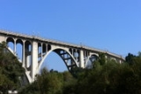
. This spur also carried SR 134 after the Ventura Freeway was built to the east but before it was built west of the split with the spur. After crossing Figueroa Street, Colorado Boulevard splits from Linda Vista Avenue and then passes over the Arroyo Seco
Arroyo Seco (Los Angeles County)
The Arroyo Seco, meaning "dry stream" in Spanish, is a seasonal river, canyon, watershed, and cultural area in Los Angeles County, California, United States. The Arroyo Seco has been called the most celebrated canyon in Southern California.-River course:...
on the Colorado Street Bridge into Pasadena.
Through Pasadena
In Pasadena, Colorado Boulevard crosses the short State Route 710 spur and forms the north end of State Route 110 (Arroyo Parkway). Colorado Street, renamed "Boulevard" in 1958, runs through Old Town PasadenaOld Town Pasadena
Old Pasadena is the original commercial center of Pasadena, a city in California, United States that arose from one of the most prosperous areas of the state, and had a latter day revitalization after a period of decay...
from Arroyo Parkway to Orange Grove Boulevard. It is the north–south zero axis of the street grid in Pasadena (the east–west axis is Fair Oaks Avenue
Fair Oaks Avenue (Pasadena, California)
Fair Oaks Avenue in Pasadena, California, is a major north-south road connecting the communities of Altadena, Pasadena, and South Pasadena, running in length. It starts at its southernmost end in South Pasadena at Huntington Drive. It travels due north to a terminus above Loma Alta Ave. in...
). The Tournament of Roses parade route travels north on Orange Grove Avenue then east along Colorado Boulevard as far as Sierra Madre Boulevard
Sierra Madre Boulevard
Sierra Madre Boulevard is a long road connecting five suburbs of Pasadena, California; Arcadia, Sierra Madre, Hastings Ranch, East Pasadena, and San Marino. For the most part, it is a winding road divided by a grassy median, but the part between Pasadena and Arcadia is a two-lane road. Built...
, where it heads north to Victory Park
Victory Park
Victory Park is a master planned development northwest of downtown Dallas, Texas and north of Spur 366 . It is along Interstate 35E, part of the Stemmons Corridor and Uptown....
. Most major Pasadena attractions are found along or within one block of Colorado Boulevard. Pasadena City College
Pasadena City College
Pasadena City College is a community college in Pasadena, California, USA, located on Colorado Boulevard. PCC is the third largest community college campus in the United States. PCC was founded in 1924 as Pasadena Junior College. In 1954, Pasadena Junior College merged with another junior...
is located at 1570 E. Colorado Boulevard. The street was mentioned in Jan and Dean
Jan and Dean
Jan and Dean were a rock and roll duo, popular from the late 1950s through the mid 1960s, consisting of William Jan Berry and Dean Ormsby Torrence...
's 1964 hit song The Little Old Lady from Pasadena
The Little Old Lady from Pasadena
"The Little Old Lady from Pasadena" is a song written by Don Altfeld, Jan Berry and Roger Christian, and recorded by 1960s American pop singers, Jan and Dean. The song reached number three on the Billboard Hot 100 chart in 1964...
. The road leaves the city into unincorporated East Pasadena, where it intersects Rosemead Boulevard (Former State Route 19
State Route 19 (California)
State Route 19 , also known as Lakewood Boulevard and Rosemead Boulevard, is a state highway in the Los Angeles area of the U.S. state of California...
).
Through Arcadia and Monrovia
Colorado Boulevard becomes Colorado Street as it crosses Michillinda AvenueMichillinda Avenue (Pasadena)
Michillinda Avenue in Pasadena, California, basically marks the easternmost boundary of the city. Michillinda starts at its south end at Huntington Drive and continues north to a terminus at the base of the foothills of the San Gabriel Mountains at the intersection of Carriage House Road...
from East Pasadena into Arcadia. Through Arcadia, the street parallels the Foothill Freeway, providing access to many of the neighborhoods in west Arcadia; freeway access is provided via a separated interchange with Baldwin Avenue. Colorado Street then turns southeast and splits into two streets--Colorado Boulevard, which continues east, and Colorado Place, a short segment of old US 66 that goes southeast to merge with Huntington Drive
Huntington Drive
Huntington Drive is a major east–west street in Southern California. It runs from the merge of Soto Street and Mission Road near the Lincoln Park neighborhood of Los Angeles east through the El Sereno section of Los Angeles, South Pasadena, San Marino, Alhambra, San Gabriel, Arcadia,...
near the Santa Anita Racetrack.
From the split, Colorado Boulevard (originally named Orange Street) becomes a primarily residential street, with some commercial zones near Santa Anita Avenue in Arcadia. The street passes under the Foothill Freeway between First and Second Streets in Arcadia with no access, in front of Monrovia High School
Monrovia High School
Monrovia High School is a public high school located in Monrovia, California, a northeastern suburb of Los Angeles. Monrovia High School is the only 9-12 comprehensive high school in the Monrovia Unified School District...
, and through Old Town Monrovia
Monrovia, California
Monrovia is a city located in the foothills of the San Gabriel Mountains in the San Gabriel Valley of Los Angeles County, California, United States. The population was 36,590 at the 2010 census, down from 36,929 at the 2000 census...
before ending at Shamrock Avenue at Recreation Park in Monrovia. (This segment of Shamrock Avenue was once part of an early alignment of US 66 and had been named Foothill Boulevard
Foothill Boulevard (Southern California)
Foothill Boulevard is a major road in the city and county of Los Angeles, as well as an arterial road in the city and county of San Bernardino, stretching well over 60 miles in length, with some notable breaks along the route...
.)
History
The most original portion of Colorado Boulevard ran from Orange Grove Boulevard to Broadway, now Arroyo Parkway. This portion of the street always contained many shops, banks, hotels, and major commercial industries. By the late 19th century, this part of the Colorado had become so popular, it was becoming a traffic bottleneck, and as early as May 1900 there were public outcries to City Council to widen the road. It wasn't until 1929 that the City undertook the major and unprecedented task of cutting back the buildings along Colorado 14 feet (4.3 m) on each side. This undertaking created a monumental amount of legal red tape as well as many engineering dilemmas which were handled with amazing results. At the same much of the Victorian facings on the buildings were replaced with Spanish and Art Deco designs.Colorado Street and Colorado Boulevard carried pre-1964 Legislative Route 161 from its west end to the merge with Huntington Drive
Huntington Drive
Huntington Drive is a major east–west street in Southern California. It runs from the merge of Soto Street and Mission Road near the Lincoln Park neighborhood of Los Angeles east through the El Sereno section of Los Angeles, South Pasadena, San Marino, Alhambra, San Gabriel, Arcadia,...
(via Colorado Place). This was signed as State Route 134 west of Figueroa Street
Figueroa Street
Figueroa Street is a street in Los Angeles County, California named for General José Figueroa , governor of Alta California from 1833 to 1835, who oversaw the secularization of the missions of California...
, U.S. Route 66 Alternate (US 66 before the end of 1940) from Figueroa Street to Arroyo Parkway, and U.S. Route 66 from Arroyo Parkway to Huntington Drive.
In 1954, the Colorado Freeway was opened between Holly Street in Pasadena and Eagle Vista Drive and Colorado Boulevard in Eagle Rock to help alleviate traffic congestion due to the narrow Colorado Street Bridge over the Arroyo Seco. The new freeway connected the two communities until 1971, when the entire freeway was closed and upgraded, as well as partially rerouted as the new Ventura Freeway. A short segment of the original Colorado Freeway remains as an on-ramp/off-ramp between Colorado Boulevard in Eagle Rock and the Figueroa Street off-ramp of the present Ventura Freeway.
In the 1964 renumbering
1964 state highway renumbering (California)
In 1963 and 1964, the California Division of Highways implemented a major renumbering of its state highways. The majority of sign routes — those marked for the public — kept their numbers; the main changes were to the legislative routes, which had their numbers changed to match the sign routes...
, LR 161 remained State Route 134 west of Pasadena, though this was being moved to the new alignment (now the Ventura Freeway
Ventura Freeway
The Ventura Freeway is a freeway in southern California running from Ventura to Pasadena. It is the principal east-west route through Ventura County and in the southern San Fernando Valley in Los Angeles County. From Ventura to its intersection with the Hollywood Freeway in the southeastern San...
); until the freeway was completed through Pasadena in the mid-1970s, Colorado Boulevard was still signed as State Route 134 between Orange Grove Avenue and Arroyo Parkway. Through and east of Pasadena, LR 161 became State Route 248, but was signed as US 66 and continued east on Huntington Drive
Huntington Drive
Huntington Drive is a major east–west street in Southern California. It runs from the merge of Soto Street and Mission Road near the Lincoln Park neighborhood of Los Angeles east through the El Sereno section of Los Angeles, South Pasadena, San Marino, Alhambra, San Gabriel, Arcadia,...
to the interchange
Interchange (road)
In the field of road transport, an interchange is a road junction that typically uses grade separation, and one or more ramps, to permit traffic on at least one highway to pass through the junction without directly crossing any other traffic stream. It differs from a standard intersection, at which...
with Interstate 210
Interstate 210 (California)
Interstate 210 and State Route 210 together form a contiguous highway, called the Foothill Freeway, in the Greater Los Angeles area of the U.S. state of California. The western portion of the route is an auxiliary Interstate Highway, while the eastern portion is a state highway...
(Foothill Freeway) in Monrovia.
The US 66 shields began to come down along the length of Route 248 in 1975, soon after Interstate 210
Interstate 210 (California)
Interstate 210 and State Route 210 together form a contiguous highway, called the Foothill Freeway, in the Greater Los Angeles area of the U.S. state of California. The western portion of the route is an auxiliary Interstate Highway, while the eastern portion is a state highway...
was completed through Pasadena. SR 248 was never signed as such, though it did appear on some maps in the 1970s and 1980s. The segment within the city of Pasadena was deleted from the state highway system in 1986. The rest was removed in 1992. Along with the moving of SR 134 to the Ventura Freeway
Ventura Freeway
The Ventura Freeway is a freeway in southern California running from Ventura to Pasadena. It is the principal east-west route through Ventura County and in the southern San Fernando Valley in Los Angeles County. From Ventura to its intersection with the Hollywood Freeway in the southeastern San...
, this resulted in Colorado Street and Colorado Boulevard becoming a local road.
Transit
Many buses serve Colorado Boulevard. Metro LocalMetro Local
Metro Local is a bus system in Los Angeles County operated by the Los Angeles County Metropolitan Transportation Authority . This retronym designation was placed to differentiate it from the Metro Rapid service...
lines 180 and 181 and Metro Rapid
Metro Rapid
Metro Rapid is a bus rapid transit service in Los Angeles County, California that operates in mixed traffic environments and has fewer stops than the Metro Local service. The system is mainly operated by LACMTA. Two routes are operated by Santa Monica Transit and one by Culver City Transit...
line 780 serve most of Colorado Boulevard. Also, Metro Local
Metro Local
Metro Local is a bus system in Los Angeles County operated by the Los Angeles County Metropolitan Transportation Authority . This retronym designation was placed to differentiate it from the Metro Rapid service...
lines 177, 256, 686, and Foothill Transit
Foothill Transit
Foothill Transit is a joint powers authority of 21 member cities in the San Gabriel and Pomona Valleys. It operates a fixed-route bus public transit service in the San Gabriel Valley of Greater Los Angeles, California.-Overview:...
line 187 serve parts of Colorado Boulevard, beginning in Old Pasadena. Metro Local
Metro Local
Metro Local is a bus system in Los Angeles County operated by the Los Angeles County Metropolitan Transportation Authority . This retronym designation was placed to differentiate it from the Metro Rapid service...
lines 81, 84, 180, 181,Metro Rapid
Metro Rapid
Metro Rapid is a bus rapid transit service in Los Angeles County, California that operates in mixed traffic environments and has fewer stops than the Metro Local service. The system is mainly operated by LACMTA. Two routes are operated by Santa Monica Transit and one by Culver City Transit...
line 780 and LADOT Dash Eagle Rock/Higland park route serves most of Colorado Boulevard in Eagle Rock
Eagle Rock, Los Angeles, California
In 1909, Hill Avenue, now Hill Drive, was one of Eagle Rock's most beautiful streets. Other streets were Royal Drive , Acacia Street , Kenilworth Avenue , Highland Avenue , and Fairmont Avenue...
. Metro Local
Metro Local
Metro Local is a bus system in Los Angeles County operated by the Los Angeles County Metropolitan Transportation Authority . This retronym designation was placed to differentiate it from the Metro Rapid service...
Lines 84, 183 and Glendale Beeline
Glendale Beeline
Glendale Beeline is Glendale, California's transportation service, providing local routes that serve the need of those commuting within the city itself or who plan on using the bus to connect with rail service to Los Angeles or surrounding suburbs. The bus lines complements the Los Angeles County...
Route 6 serve Colorado Street in Glendale.