
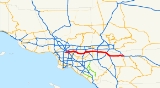
California State Route 60
Encyclopedia
State Route 60 is a state highway
in the U.S. state
of California
. It runs from Interstate 10 near the Los Angeles River
in Los Angeles
east to I-10 in Riverside County
, with overlaps at State Route 57
and Interstate 215
.
.
Route 60 serves the cities
and communities
on the eastern side of the Los Angeles
metropolitan area
and runs along the south side of the San Gabriel Valley
. The west terminus of the freeway is at the East Los Angeles Interchange
complex. The east terminus is at the junction
with the San Bernardino Freeway, Interstate 10 (I-10) in Beaumont
. The freeway is known as the Pomona Freeway west of its junction with State Route 91 and Interstate 215
in Riverside
. East of this interchange the freeway is known as the Moreno Valley Freeway until its terminus at its junction with Interstate 10. The freeway shares the alignment of the Orange Freeway, State Route 57 for some 2 miles (3.2 km) in Diamond Bar
and also shares the alignment of Interstate 215
for about 5 miles (8 km) in Riverside. The route takes its number from former U.S. Route 60
.
complex and its junction with the Riverside Freeway, State Route 91
(SR 91) and Interstate 215
(I-215) in Riverside
.
It traverses through Los Angeles
, San Bernardino
, and Riverside
Counties. As it passes through many of Los Angeles' east side suburbs in southern San Gabriel
and Pomona
Valleys, it is a major transportation corridor. For the majority of its length it is generally parallel to, and south of, the San Bernardino Freeway
, Interstate 10 (I-10), and generally parallel to, and north of, the Riverside Freeway, California State Route 91
. Traffic congestion is exacerbated by the rapid population growth and, therefore, residential, commercial, and industrial development in the inland communities known informally as the Inland Empire
. In particular, it has become increasingly clogged of late with shipping container
-laden trucks travelling from the ports of Los Angeles and Long Beach
to rail yards and warehouses in the Inland Empire.
, connecting Riverside
to communities further east in the Inland Empire
and (via Interstate 10) to the Coachella Valley
. Its western terminus is at the intersection of the Pomona (State Route 60) and Riverside Freeways (State Route 91 and Interstate 215
), near downtown Riverside. The freeway is cosigned as State Route 60 and Interstate 215 for several miles in Riverside, traveling southeast, until the border between Riverside and Moreno Valley
, where Interstate 215 branches southward as the Escondido Freeway
, and State Route 60 (maintaining the Moreno Valley Freeway designation) branches eastward for approximately 20 miles (32.2 km). East of Moreno Valley, Route 60 technically loses its freeway status and becomes an expressway
(because Caltrans has not yet found the money to close off all driveways and rebuild all at-grade intersections as grade-separated interchanges). After passing through Moreno Valley and the rugged hill country to the east (known as the Badlands
to the locals), Route 60 ends at Interstate 10 in Beaumont
.
As a result of the rapid development of the Inland Empire since the 1980s, the Moreno Valley Freeway now suffers from severe traffic congestion. The northwestern section that is concurrently signed with Interstate 215 recently underwent significant construction to improve traffic flow.
ran from Los Angeles
to the Arizona
state line, where it continued its nationwide trek, often overlapping U.S. 99 and U.S. 70 along the way. The advent of Interstate 10 created a situation where, at one point, four different signed routes would run along the state-maintained highway
.
In 1964, California
implemented a plan to simplify its highway-numbering system, where one state highway had only one route number and concurrencies were sternly discouraged. As a result, the U.S. 60 designation (along with U.S. 70 and U.S. 99) was removed. Interstate 10 (as Route 10) superseded U.S. 60's alignment from Beaumont and towards the Arizona
state line, even though the routing was only partly a freeway. This left the officially designated Route 60 from Beaumont to Los Angeles orphaned from its original U.S. Highway (which to this day begins at a point on Interstate 10 east of Quartzsite, Arizona
). This new Route 60 was provisionally signed as a U.S. Highway since the designation would guide motorists from Los Angeles to Arizona in the absence of a completed freeway for Interstate 10; when all of Route 10 was upgraded to a freeway, the U.S. Highway designation disappeared.
At least one California highway sign managed to be overlooked for many years afterward. A sign on Hess Boulevard at California State Route 62
in the unincorporated town of Morongo Valley
pointing not to Interstate 10 but to U.S. 60 (with evidence of the sign having pointed to both U.S. 70 and U.S. 99 as well) stood through the early 2000s. It has since been removed.
The stretch of Route 60 along the Moreno Valley Freeway made national headlines in April, 2004, when five-year-old Ruby Bustamante of Indio
and her 26-year-old mother, Norma, were reported missing. Their car had left the road, apparently unwitnessed, between the gap in two guard rails on April 4. It then crashed underneath a tree in a deep ravine. Though Mrs. Bustamante lost her life, presumably at the moment of impact, Ruby survived on her own for ten days on cups of uncooked Top Ramen noodles and bottles of Gatorade
which were in the car.
{| class=wikitable
!County
!Location
!Postmile
!Exit
!Destinations
!Notes
|-
|rowspan=34|Los Angeles
LA 0.00-R30.46
|rowspan=9|Los Angeles
|0.00
|1
|
|Westbound exit and eastbound entrance
|-
|0.04
|1A
|Mateo Street, Santa Fe Avenue
|Westbound exit and eastbound entrance
|-
|0.38
|1B
|Soto Street
|No eastbound exit
|-
|R0.55
|1A
|
|Eastbound exit and westbound entrance
|-
|R0.55
|1C
|
|Westbound exit and eastbound entrance
|-
|R1.48
|1D
|Whittier Boulevard, Lorena Street
|Signed as exit 1B eastbound
|-bgcolor=#ffdddd
|R1.94
|2
|Indiana Street
|Westbound exit and eastbound entrance
|-
|R2.59
|3A
|Downey Road
|
|-
|R3.27
|3B
|
|
|-
|Monterey Park
|R4.43
|4
|Atlantic Boulevard
|
|-
|rowspan=3|Montebello
|bgcolor=#ffdddd|R5.16
|bgcolor=#ffdddd|6A
|bgcolor=#ffdddd|Findlay Avenue
|bgcolor=#ffdddd|Eastbound exit and westbound entrance
|-
|R5.89
|6B
|Garfield Avenue, Wilcox Avenue
|Signed as exit 6 westbound
|-
|R7.77
|8
|Paramount Boulevard – Montebello
|
|-
|rowspan=2|Rosemead
|R8.55
|9
|San Gabriel Boulevard – Rosemead
|
|-
|9.51
|10A
|
|
|-
|rowspan=2|South El Monte
|10.23
|10B
|Santa Anita Avenue – South El Monte
|
|-
|11.01
|11
|Peck Road
|
|-
|rowspan=8|Industry
|11.71
|12
|
|
|-
|12.63
|13
|Crossroads Parkway
|
|-
|14.26
|14
|Seventh Avenue – Industry
|Signed as exits 14A (south) and 14B (north) eastbound
|-
|15.93
|18A
|Hacienda Boulevard
|Former SR 39
|-
|17.97
|18B
|Azusa
Avenue
|
|-
|19.46
|19
|Fullerton Road
|
|-
|20.43
|20
|Nogales Street
|
|-
|R21.48
|21
|Fairway Drive – Walnut
|
|-
|rowspan=5|Diamond Bar
|R22.97
|23
|Brea Canyon Road
|
|-bgcolor=#ddffdd
|R23.56
|24A
|
|West end of SR 57 overlap
|-
|R24.45
|24B
|Grand Avenue – Diamond Bar
|
|-bgcolor=#ddffdd
|R25.46
|25
|
|East end of SR 57 overlap; westbound exit is via exit 26
|-
|R25.56
|26
|Diamond Bar Boulevard
|
|-
|rowspan=4|Pomona
|R28.04
|28
|Phillips Ranch Road
|
|-
|R29.39
|29A
|
|Signed as exit 29B westbound; eastbound exit to SR 71 north is via exit 29B
|-
|R29.39
|29B
|Garey Avenue
|Signed as exit 29A westbound
|-
|R30.33
|30
|Reservoir Street
|
|-
|rowspan=9|San Bernardino
R0.00-R9.96
|rowspan=3|Chino
|R1.37
|32
|Ramona Avenue
|
|-
|R2.37
|33
|Central Avenue
|
|-
|R3.60
|34
|Mountain Avenue
|
|-
|rowspan=6|Ontario
|R4.58
|35
|
|
|-
|R5.86
|36
|Grove Avenue – Ontario Airport
|
|-
|R6.86
|37
|Vineyard Avenue
|
|-
|R7.87
|38
|Archibald Avenue
|
|-
|R8.91
|39
|Haven Avenue – Ontario Airport
|
|-
|rowspan=2|R9.96
|rowspan=2|40
|rowspan=2|Milliken Avenue, Hamner Avenue
|rowspan=2|Signed as exit 41A westbound; former SR 31
|-
|rowspan=33|Riverside
R0.00-30.50
|
|-
|
|R0.49
|41
|
|Signed as exit 41B westbound
|-
|
|R1.99
|42
|Van Buren Boulevard, Etiwanda Avenue, Mission Boulevard
|
|-
|
|R3.03
|43
|Country Village Road, Mission Boulevard (SR 60 Bus. east)
|
|-
|
|R4.55
|45
|Pedley Road
|
|-
|
|R5.58
|46
|Pyrite Street
|
|-
|rowspan=2|Rubidoux
|7.53
|48
|Valley Way, Mission Boulevard (SR 60 Bus.) – Rubidoux
|
|-
|9.56
|50
|Rubidoux Boulevard – Rubidoux
|
|-
|rowspan=13|Riverside
|11.07
|52A
|Market Street – Downtown Riverside
|
|-
|11.73
|52B
|Main Street
|
|-
|R12.06
|53A
|
|Signed as exit 34B westbound; former US 91 south
|-bgcolor=#ddffdd
|R12.21
43.27Indicates that the postmile represents the distance along I-215
rather than SR 60.
|53B
|
|West end of I-215 overlap; no exit number westbound; former I-15E north / US 91 north / US 395
north
|-bgcolor=#d3d3d3
|42.84
|34A
|Spruce Street
|Closed
|-
|42.16
|33
|3rd Street, Blaine Street
|
|-
|41.49
|32
|University Avenue (SR 60 Bus. west)
|
|-
|40.98
|31
|Martin Luther King Boulevard
|
|-bgcolor=#d3d3d3
|40.28
|31
|El Cerrito Drive
|Closed
|-
|39.48
|30B
|Watkins Drive, Central Avenue
|
|-
|R38.92
|30A
|Fair Isle Drive – Box Springs
|No westbound exit from I-215 north
|-bgcolor=#ddffdd
|R38.34
R12.21
|58
|
|East end of I-215 overlap; no exit number eastbound; former I-15E south / US 395
south
|-
|13.31
|59
|Day Street
|
|-
|rowspan=9|Moreno Valley
|14.32
|60
|Frederick Street, Pigeon Pass Road (SR 60 Bus. via Sunnymead Boulevard)
|
|-
|15.34
|61
|Heacock Street
|
|-
|16.35
|62
|Perris Boulevard
|
|-
|18.37
|64
|Nason Street
|
|-
|19.20
|65
|Moreno Beach Drive
|
|-
|20.37
|66
|Redlands Boulevard – Moreno
|
|-
|21.37
|67
|Theodore Street
|
|-
|22.10
|68
|Gilman Springs Road – Hemet
, San Jacinto
|Former SR 177
|-
|27.98
|74
|Jack Rabbit Trail
|Interchange eastbound; at-grade intersection westbound; no exit number westbound
|-
|rowspan=3|Beaumont
|colspan=4 align=center|Short gap in freeway
|-
|30.50
|
|Beaumont
|Eastbound exit and westbound entrance
|-
|30.50
|
|
|Eastbound exit and westbound entrance
State highway
State highway, state road or state route can refer to one of three related concepts, two of them related to a state or provincial government in a country that is divided into states or provinces :#A...
in the U.S. state
U.S. state
A U.S. state is any one of the 50 federated states of the United States of America that share sovereignty with the federal government. Because of this shared sovereignty, an American is a citizen both of the federal entity and of his or her state of domicile. Four states use the official title of...
of California
California
California is a state located on the West Coast of the United States. It is by far the most populous U.S. state, and the third-largest by land area...
. It runs from Interstate 10 near the Los Angeles River
Los Angeles River
The Los Angeles River is a river that starts in the San Fernando Valley, in the Simi Hills and Santa Susana Mountains, and flows through Los Angeles County, California, from Canoga Park in the western end of the San Fernando Valley, nearly southeast to its mouth in Long Beach...
in Los Angeles
Los Ángeles
Los Ángeles is the capital of the province of Biobío, in the commune of the same name, in Region VIII , in the center-south of Chile. It is located between the Laja and Biobío rivers. The population is 123,445 inhabitants...
east to I-10 in Riverside County
Riverside County, California
Riverside County is a county in the U.S. state of California. One of 58 California counties, it covers in the southern part of the state, and stretches from Orange County to the Colorado River, which forms the state border with Arizona. The county derives its name from the city of Riverside,...
, with overlaps at State Route 57
California State Route 57
State Route 57 , also known as the Orange Freeway, is a north–south state highway in the Greater Los Angeles Area of the U.S. state of California. It connects the interchange of Interstate 5 and State Route 22 near downtown Orange, locally known as the Orange Crush, with the Glendora Curve...
and Interstate 215
Interstate 215 (California)
Interstate 215 is a long north–south Interstate highway in the Inland Empire region of Southern California. It is an auxiliary route of Interstate 15 , running from Murrieta to northern San Bernardino...
.
Route description
This route is part of the California Freeway and Expressway SystemCalifornia Freeway and Expressway System
The California Freeway and Expressway System is a system of existing or planned freeways and expressways in the U.S. state of California. It is defined by the Streets and Highways Code.-List of roads in the system:*State Route 1 *State Route 2...
.
Route 60 serves the cities
City
A city is a relatively large and permanent settlement. Although there is no agreement on how a city is distinguished from a town within general English language meanings, many cities have a particular administrative, legal, or historical status based on local law.For example, in the U.S...
and communities
Community
The term community has two distinct meanings:*a group of interacting people, possibly living in close proximity, and often refers to a group that shares some common values, and is attributed with social cohesion within a shared geographical location, generally in social units larger than a household...
on the eastern side of the Los Angeles
Los Ángeles
Los Ángeles is the capital of the province of Biobío, in the commune of the same name, in Region VIII , in the center-south of Chile. It is located between the Laja and Biobío rivers. The population is 123,445 inhabitants...
metropolitan area
Metropolitan area
The term metropolitan area refers to a region consisting of a densely populated urban core and its less-populated surrounding territories, sharing industry, infrastructure, and housing. A metropolitan area usually encompasses multiple jurisdictions and municipalities: neighborhoods, townships,...
and runs along the south side of the San Gabriel Valley
San Gabriel Valley
The San Gabriel Valley is one of the principal valleys of Southern California, United States. It lies to the east of Los Angeles, to the north of the Puente Hills, to the south of the San Gabriel Mountains, and west of the Inland Empire. It derives its name from the San Gabriel River that flows...
. The west terminus of the freeway is at the East Los Angeles Interchange
East Los Angeles Interchange
The East Los Angeles Interchange complex is the busiest freeway interchange in the world, with its southern portion handling over 550,000 vehicles per day . The northern portion, called the San Bernardino Split, is often considered a separate interchange. The interchange was named the Eugene A....
complex. The east terminus is at the junction
Junction (road)
A road junction is a location where vehicular traffic going in different directions can proceed in a controlled manner designed to minimize accidents. In some cases, vehicles can change between different routes or directions of travel.-Origins:...
with the San Bernardino Freeway, Interstate 10 (I-10) in Beaumont
Beaumont, California
Beaumont is a city in Riverside County, California, United States in the Greater Los Angeles area.Now a growing, community planned city, the population was 36,877 at the 2010 census, and expected to be up to 125,000 projected by 2040, making Beaumont as California's next, newest fastest-growing...
. The freeway is known as the Pomona Freeway west of its junction with State Route 91 and Interstate 215
Interstate 215 (California)
Interstate 215 is a long north–south Interstate highway in the Inland Empire region of Southern California. It is an auxiliary route of Interstate 15 , running from Murrieta to northern San Bernardino...
in Riverside
Riverside, California
Riverside is a city in Riverside County, California, United States, and the county seat of the eponymous county. Named for its location beside the Santa Ana River, it is the largest city in the Riverside-San Bernardino-Ontario metropolitan area of Southern California, 4th largest inland California...
. East of this interchange the freeway is known as the Moreno Valley Freeway until its terminus at its junction with Interstate 10. The freeway shares the alignment of the Orange Freeway, State Route 57 for some 2 miles (3.2 km) in Diamond Bar
Diamond Bar, California
Diamond Bar is a city in eastern Los Angeles County, California, United States. The population was 55,544 at the 2010 census, down from 56,287 at the 2000 census. It is named after the "diamond over a bar" branding iron registered in 1918 by ranch owner Frederick E...
and also shares the alignment of Interstate 215
Interstate 215 (California)
Interstate 215 is a long north–south Interstate highway in the Inland Empire region of Southern California. It is an auxiliary route of Interstate 15 , running from Murrieta to northern San Bernardino...
for about 5 miles (8 km) in Riverside. The route takes its number from former U.S. Route 60
U.S. Route 60
U.S. Route 60 is an east–west United States highway, running from the Atlantic Ocean on the east coast in Virginia to western Arizona. Despite the final "0" in its number, indicating a transcontinental designation, the 1926 route formerly ended in Springfield, Missouri, at its intersection...
.
Pomona Freeway
The Pomona Freeway is the assigned name Route 60 (SR 60) between its western terminus at the East Los Angeles InterchangeEast Los Angeles Interchange
The East Los Angeles Interchange complex is the busiest freeway interchange in the world, with its southern portion handling over 550,000 vehicles per day . The northern portion, called the San Bernardino Split, is often considered a separate interchange. The interchange was named the Eugene A....
complex and its junction with the Riverside Freeway, State Route 91
California State Route 91
State Route 91 is a major east–west freeway located entirely within Southern California and serving several regions of the Greater Los Angeles metropolitan area...
(SR 91) and Interstate 215
Interstate 215 (California)
Interstate 215 is a long north–south Interstate highway in the Inland Empire region of Southern California. It is an auxiliary route of Interstate 15 , running from Murrieta to northern San Bernardino...
(I-215) in Riverside
Riverside, California
Riverside is a city in Riverside County, California, United States, and the county seat of the eponymous county. Named for its location beside the Santa Ana River, it is the largest city in the Riverside-San Bernardino-Ontario metropolitan area of Southern California, 4th largest inland California...
.
It traverses through Los Angeles
Los Angeles County, California
Los Angeles County is a county in the U.S. state of California. As of 2010 U.S. Census, the county had a population of 9,818,605, making it the most populous county in the United States. Los Angeles County alone is more populous than 42 individual U.S. states...
, San Bernardino
San Bernardino County, California
San Bernardino County is a county in the U.S. state of California. As of the 2010 census, the population was 2,035,210, up from 1,709,434 as of the 2000 census...
, and Riverside
Riverside County, California
Riverside County is a county in the U.S. state of California. One of 58 California counties, it covers in the southern part of the state, and stretches from Orange County to the Colorado River, which forms the state border with Arizona. The county derives its name from the city of Riverside,...
Counties. As it passes through many of Los Angeles' east side suburbs in southern San Gabriel
San Gabriel Valley
The San Gabriel Valley is one of the principal valleys of Southern California, United States. It lies to the east of Los Angeles, to the north of the Puente Hills, to the south of the San Gabriel Mountains, and west of the Inland Empire. It derives its name from the San Gabriel River that flows...
and Pomona
Pomona Valley
The Pomona Valley, located between the San Gabriel Valley and Cucamonga Valley in Southern California, straddles the border between Los Angeles County and San Bernardino County. Back on March 1, 1893 the California Assembly voted 54-14 for a new county to form in the region, San Antonio County,...
Valleys, it is a major transportation corridor. For the majority of its length it is generally parallel to, and south of, the San Bernardino Freeway
San Bernardino Freeway
The San Bernardino Freeway, formerly known as the Ramona Freeway is a freeway in Los Angeles and Orange Counties in the southern part of the U.S. state of California. It refers to the following two segments:...
, Interstate 10 (I-10), and generally parallel to, and north of, the Riverside Freeway, California State Route 91
California State Route 91
State Route 91 is a major east–west freeway located entirely within Southern California and serving several regions of the Greater Los Angeles metropolitan area...
. Traffic congestion is exacerbated by the rapid population growth and, therefore, residential, commercial, and industrial development in the inland communities known informally as the Inland Empire
Inland Empire (California)
The Inland Empire is a region in Southern California. The region sits directly east of the Los Angeles metropolitan area. The Inland Empire most commonly is used in reference to the U.S. Census Bureau's federally-defined Riverside-San Bernardino-Ontario metropolitan area, which covers more than...
. In particular, it has become increasingly clogged of late with shipping container
Intermodal container
An intermodal container is a standardized reusable steel box used for the safe, efficient and secure storage and movement of materials and products within a global containerized intermodal freight transport system...
-laden trucks travelling from the ports of Los Angeles and Long Beach
Long Beach, California
Long Beach is a city situated in Los Angeles County in Southern California, on the Pacific coast of the United States. The city is the 36th-largest city in the nation and the seventh-largest in California. As of 2010, its population was 462,257...
to rail yards and warehouses in the Inland Empire.
Moreno Valley Freeway
The Moreno Valley Freeway is a freeway segment of State Route 60 and Interstate 215Interstate 215 (California)
Interstate 215 is a long north–south Interstate highway in the Inland Empire region of Southern California. It is an auxiliary route of Interstate 15 , running from Murrieta to northern San Bernardino...
, connecting Riverside
Riverside, California
Riverside is a city in Riverside County, California, United States, and the county seat of the eponymous county. Named for its location beside the Santa Ana River, it is the largest city in the Riverside-San Bernardino-Ontario metropolitan area of Southern California, 4th largest inland California...
to communities further east in the Inland Empire
Inland Empire (California)
The Inland Empire is a region in Southern California. The region sits directly east of the Los Angeles metropolitan area. The Inland Empire most commonly is used in reference to the U.S. Census Bureau's federally-defined Riverside-San Bernardino-Ontario metropolitan area, which covers more than...
and (via Interstate 10) to the Coachella Valley
Coachella Valley
Coachella Valley is a large valley landform in Southern California. The valley extends for approximately 45 miles in Riverside County southeast from the San Bernardino Mountains to the saltwater Salton Sea, the largest lake in California...
. Its western terminus is at the intersection of the Pomona (State Route 60) and Riverside Freeways (State Route 91 and Interstate 215
Interstate 215 (California)
Interstate 215 is a long north–south Interstate highway in the Inland Empire region of Southern California. It is an auxiliary route of Interstate 15 , running from Murrieta to northern San Bernardino...
), near downtown Riverside. The freeway is cosigned as State Route 60 and Interstate 215 for several miles in Riverside, traveling southeast, until the border between Riverside and Moreno Valley
Moreno Valley, California
Moreno Valley is a city located in Riverside County, California.A relatively young city, its rapid growth in the 1980s and the first decade of the 21st century made it second-largest city in Riverside County by population, and one of the Inland Empire's population centers. As of the 2010 census,...
, where Interstate 215 branches southward as the Escondido Freeway
Escondido Freeway
The Escondido Freeway is a named freeway in Southern California. It refers to the following segments:*California State Route 15, from Interstate 5 southeast of Downtown San Diego and Interstate 8 in San Diego...
, and State Route 60 (maintaining the Moreno Valley Freeway designation) branches eastward for approximately 20 miles (32.2 km). East of Moreno Valley, Route 60 technically loses its freeway status and becomes an expressway
Limited-access road
A limited-access road known by various terms worldwide, including limited-access highway, dual-carriageway and expressway, is a highway or arterial road for high-speed traffic which has many or most characteristics of a controlled-access highway , including limited or no access to adjacent...
(because Caltrans has not yet found the money to close off all driveways and rebuild all at-grade intersections as grade-separated interchanges). After passing through Moreno Valley and the rugged hill country to the east (known as the Badlands
The Badlands (California)
The Badlands are a mountain range in Riverside County, California. They are also known as the San Timoteo Badlands....
to the locals), Route 60 ends at Interstate 10 in Beaumont
Beaumont, California
Beaumont is a city in Riverside County, California, United States in the Greater Los Angeles area.Now a growing, community planned city, the population was 36,877 at the 2010 census, and expected to be up to 125,000 projected by 2040, making Beaumont as California's next, newest fastest-growing...
.
As a result of the rapid development of the Inland Empire since the 1980s, the Moreno Valley Freeway now suffers from severe traffic congestion. The northwestern section that is concurrently signed with Interstate 215 recently underwent significant construction to improve traffic flow.
History
Before 1964, U.S. 60U.S. Route 60
U.S. Route 60 is an east–west United States highway, running from the Atlantic Ocean on the east coast in Virginia to western Arizona. Despite the final "0" in its number, indicating a transcontinental designation, the 1926 route formerly ended in Springfield, Missouri, at its intersection...
ran from Los Angeles
Los Ángeles
Los Ángeles is the capital of the province of Biobío, in the commune of the same name, in Region VIII , in the center-south of Chile. It is located between the Laja and Biobío rivers. The population is 123,445 inhabitants...
to the Arizona
Arizona
Arizona ; is a state located in the southwestern region of the United States. It is also part of the western United States and the mountain west. The capital and largest city is Phoenix...
state line, where it continued its nationwide trek, often overlapping U.S. 99 and U.S. 70 along the way. The advent of Interstate 10 created a situation where, at one point, four different signed routes would run along the state-maintained highway
State highway
State highway, state road or state route can refer to one of three related concepts, two of them related to a state or provincial government in a country that is divided into states or provinces :#A...
.
In 1964, California
California
California is a state located on the West Coast of the United States. It is by far the most populous U.S. state, and the third-largest by land area...
implemented a plan to simplify its highway-numbering system, where one state highway had only one route number and concurrencies were sternly discouraged. As a result, the U.S. 60 designation (along with U.S. 70 and U.S. 99) was removed. Interstate 10 (as Route 10) superseded U.S. 60's alignment from Beaumont and towards the Arizona
Arizona
Arizona ; is a state located in the southwestern region of the United States. It is also part of the western United States and the mountain west. The capital and largest city is Phoenix...
state line, even though the routing was only partly a freeway. This left the officially designated Route 60 from Beaumont to Los Angeles orphaned from its original U.S. Highway (which to this day begins at a point on Interstate 10 east of Quartzsite, Arizona
Quartzsite, Arizona
Quartzsite is a town in La Paz County, Arizona, United States. According to Census Bureau estimates, the population of the town was 3,397 in 2006.Interstate 10 runs directly through Quartzsite. It is at the intersection of U.S...
). This new Route 60 was provisionally signed as a U.S. Highway since the designation would guide motorists from Los Angeles to Arizona in the absence of a completed freeway for Interstate 10; when all of Route 10 was upgraded to a freeway, the U.S. Highway designation disappeared.
At least one California highway sign managed to be overlooked for many years afterward. A sign on Hess Boulevard at California State Route 62
California State Route 62
State Route 62 is a state highway in the U.S. state of California.-Route description:This route is part of the California Freeway and Expressway System and is eligible for the State Scenic Highway System...
in the unincorporated town of Morongo Valley
Morongo Valley, California
Morongo Valley is a census-designated place in San Bernardino County, California, United States. The population was 3,552 at the 2010 census, up from 1,929 at the 2000 census.-Geography and climate:...
pointing not to Interstate 10 but to U.S. 60 (with evidence of the sign having pointed to both U.S. 70 and U.S. 99 as well) stood through the early 2000s. It has since been removed.
The stretch of Route 60 along the Moreno Valley Freeway made national headlines in April, 2004, when five-year-old Ruby Bustamante of Indio
Indio, California
Indio is a city in Riverside County, California, United States, located in the Coachella Valley of Southern California's Colorado Desert region. It lies east of Palm Springs, east of Riverside, and east of Los Angeles. It is about north of Mexicali, Baja California on the U.S.-Mexican border...
and her 26-year-old mother, Norma, were reported missing. Their car had left the road, apparently unwitnessed, between the gap in two guard rails on April 4. It then crashed underneath a tree in a deep ravine. Though Mrs. Bustamante lost her life, presumably at the moment of impact, Ruby survived on her own for ten days on cups of uncooked Top Ramen noodles and bottles of Gatorade
Gatorade
Gatorade is a brand of sports-themed food and beverage products, built around its signature product: a line of sports drinks. Gatorade is currently manufactured by PepsiCo, distributed in over 80 countries...
which were in the car.
Exit list
- Note: Except where prefixed with a letter, postmiles were measured in 1964, based on the alignment as it existed at that time, and do not necessarily reflect current mileage. The numbers reset at county lines; the start and end postmiles in each county are given in the county column.
{| class=wikitable
!County
!Location
!Postmile
!Exit
Exit number
An exit number is a number assigned to a road junction, usually an exit from a freeway. It is usually marked on the same sign as the destinations of the exit, as well as a sign in the gore....
!Destinations
!Notes
|-
|rowspan=34|Los Angeles
Los Angeles County, California
Los Angeles County is a county in the U.S. state of California. As of 2010 U.S. Census, the county had a population of 9,818,605, making it the most populous county in the United States. Los Angeles County alone is more populous than 42 individual U.S. states...
LA 0.00-R30.46
|rowspan=9|Los Angeles
Los Angeles, California
Los Angeles , with a population at the 2010 United States Census of 3,792,621, is the most populous city in California, USA and the second most populous in the United States, after New York City. It has an area of , and is located in Southern California...
|0.00
|1
|
|Westbound exit and eastbound entrance
|-
|0.04
|1A
|Mateo Street, Santa Fe Avenue
|Westbound exit and eastbound entrance
|-
|0.38
|1B
|Soto Street
Soto Street
Soto Street is a major north-south thoroughfare in Los Angeles, California, connecting the southernmost neighborhoods of the East Side, as well as the southeastern suburbs of Vernon and Huntington Park. It was first designated and paved as an arterial road in 1927...
|No eastbound exit
|-
|R0.55
|1A
|
|Eastbound exit and westbound entrance
|-
|R0.55
|1C
|
|Westbound exit and eastbound entrance
|-
|R1.48
|1D
|Whittier Boulevard, Lorena Street
|Signed as exit 1B eastbound
|-bgcolor=#ffdddd
|R1.94
|2
|Indiana Street
|Westbound exit and eastbound entrance
|-
|R2.59
|3A
|Downey Road
|
|-
|R3.27
|3B
|
|
|-
|Monterey Park
Monterey Park, California
Monterey Park is a city in Los Angeles County, California, United States, east of downtown Los Angeles. The city's motto is "Pride in the past, Faith in the future"...
|R4.43
|4
|Atlantic Boulevard
|
|-
|rowspan=3|Montebello
Montebello, California
Montebello is a city in Los Angeles County, California, United States, in the southwestern part of the San Gabriel Valley. It is located on of land just east of downtown Los Angeles. It is considered part of the Gateway Cities, and the city is a member of the Gateway Cities Council of...
|bgcolor=#ffdddd|R5.16
|bgcolor=#ffdddd|6A
|bgcolor=#ffdddd|Findlay Avenue
|bgcolor=#ffdddd|Eastbound exit and westbound entrance
|-
|R5.89
|6B
|Garfield Avenue, Wilcox Avenue
|Signed as exit 6 westbound
|-
|R7.77
|8
|Paramount Boulevard – Montebello
Montebello, California
Montebello is a city in Los Angeles County, California, United States, in the southwestern part of the San Gabriel Valley. It is located on of land just east of downtown Los Angeles. It is considered part of the Gateway Cities, and the city is a member of the Gateway Cities Council of...
|
|-
|rowspan=2|Rosemead
Rosemead, California
Rosemead is a city in Los Angeles County, California, United States. As of the 2010 census, it had a population of 53,764. Rosemead is part of a cluster of cities, along with Arcadia, Temple City, Monterey Park, San Marino, and San Gabriel, in the west San Gabriel Valley with a growing Asian...
|R8.55
|9
|San Gabriel Boulevard – Rosemead
Rosemead, California
Rosemead is a city in Los Angeles County, California, United States. As of the 2010 census, it had a population of 53,764. Rosemead is part of a cluster of cities, along with Arcadia, Temple City, Monterey Park, San Marino, and San Gabriel, in the west San Gabriel Valley with a growing Asian...
|
|-
|9.51
|10A
|
|
|-
|rowspan=2|South El Monte
South El Monte, California
South El Monte is a city in the San Gabriel Valley, in Los Angeles County, California, United States. As of the 2010 census, the city had a population of 20,116, down from 21,144 at the 2000 census.-Geography:...
|10.23
|10B
|Santa Anita Avenue – South El Monte
South El Monte, California
South El Monte is a city in the San Gabriel Valley, in Los Angeles County, California, United States. As of the 2010 census, the city had a population of 20,116, down from 21,144 at the 2000 census.-Geography:...
|
|-
|11.01
|11
|Peck Road
|
|-
|rowspan=8|Industry
Industry, California
Industry is an industrial suburb of Los Angeles in the San Gabriel Valley region of Los Angeles County. Home to over 2,500 businesses and 80,000 jobs, but only 219 residents at the 2010 census - down from 777 residents as of the 2000 United States census - the city is almost entirely industrial...
|11.71
|12
|
|
|-
|12.63
|13
|Crossroads Parkway
|
|-
|14.26
|14
|Seventh Avenue – Industry
Industry, California
Industry is an industrial suburb of Los Angeles in the San Gabriel Valley region of Los Angeles County. Home to over 2,500 businesses and 80,000 jobs, but only 219 residents at the 2010 census - down from 777 residents as of the 2000 United States census - the city is almost entirely industrial...
|Signed as exits 14A (south) and 14B (north) eastbound
|-
|15.93
|18A
|Hacienda Boulevard
|Former SR 39
California State Route 39
State Route 39 is a state highway in the U.S. state of California that travels through Orange and Los Angeles counties. Its southern terminus is at Pacific Coast Highway , in Huntington Beach, and its northern terminus is at Islip Saddle on Angeles Crest Highway in the Angeles National...
|-
|17.97
|18B
|Azusa
Azusa, California
Azusa is a city in Los Angeles County, California, United States. The population was 46,361 at the 2010 census, up from 44,712 at the 2000 census. Though sometimes assumed to be a compaction of the phrase "everything from A to Z in the USA" from an old Jack Benny joke, the place name "Azusa"...
Avenue
|
|-
|19.46
|19
|Fullerton Road
|
|-
|20.43
|20
|Nogales Street
|
|-
|R21.48
|21
|Fairway Drive – Walnut
Walnut, California
Walnut is a city in Los Angeles County, California, United States. The population was 29,172 at the 2010 census and its current mayor is Tom King, a former Detective from the Los Angeles Police Department....
|
|-
|rowspan=5|Diamond Bar
Diamond Bar, California
Diamond Bar is a city in eastern Los Angeles County, California, United States. The population was 55,544 at the 2010 census, down from 56,287 at the 2000 census. It is named after the "diamond over a bar" branding iron registered in 1918 by ranch owner Frederick E...
|R22.97
|23
|Brea Canyon Road
|
|-bgcolor=#ddffdd
|R23.56
|24A
|
|West end of SR 57 overlap
|-
|R24.45
|24B
|Grand Avenue – Diamond Bar
Diamond Bar, California
Diamond Bar is a city in eastern Los Angeles County, California, United States. The population was 55,544 at the 2010 census, down from 56,287 at the 2000 census. It is named after the "diamond over a bar" branding iron registered in 1918 by ranch owner Frederick E...
|
|-bgcolor=#ddffdd
|R25.46
|25
|
|East end of SR 57 overlap; westbound exit is via exit 26
|-
|R25.56
|26
|Diamond Bar Boulevard
|
|-
|rowspan=4|Pomona
Pomona, California
-2010:The 2010 United States Census reported that Pomona had a population of 149,058, a slight decline from the 2000 census population. The population density was 6,491.2 people per square mile...
|R28.04
|28
|Phillips Ranch Road
|
|-
|R29.39
|29A
|
|Signed as exit 29B westbound; eastbound exit to SR 71 north is via exit 29B
|-
|R29.39
|29B
|Garey Avenue
|Signed as exit 29A westbound
|-
|R30.33
|30
|Reservoir Street
|
|-
|rowspan=9|San Bernardino
San Bernardino County, California
San Bernardino County is a county in the U.S. state of California. As of the 2010 census, the population was 2,035,210, up from 1,709,434 as of the 2000 census...
R0.00-R9.96
|rowspan=3|Chino
Chino, California
Chino is a city in San Bernardino County, California, United States. It is located in the western end of the Riverside-San Bernardino Area and it is easily accessible via the Chino Valley and Pomona freeways....
|R1.37
|32
|Ramona Avenue
|
|-
|R2.37
|33
|Central Avenue
|
|-
|R3.60
|34
|Mountain Avenue
|
|-
|rowspan=6|Ontario
Ontario, California
Ontario is a city located in San Bernardino County, California, United States, 35 miles east of downtown Los Angeles. Located in the western part of the Inland Empire region, it lies just east of the Los Angeles county line and is part of the Greater Los Angeles Area...
|R4.58
|35
|
|
|-
|R5.86
|36
|Grove Avenue – Ontario Airport
|
|-
|R6.86
|37
|Vineyard Avenue
|
|-
|R7.87
|38
|Archibald Avenue
|
|-
|R8.91
|39
|Haven Avenue – Ontario Airport
|
|-
|rowspan=2|R9.96
|rowspan=2|40
|rowspan=2|Milliken Avenue, Hamner Avenue
|rowspan=2|Signed as exit 41A westbound; former SR 31
|-
|rowspan=33|Riverside
Riverside County, California
Riverside County is a county in the U.S. state of California. One of 58 California counties, it covers in the southern part of the state, and stretches from Orange County to the Colorado River, which forms the state border with Arizona. The county derives its name from the city of Riverside,...
R0.00-30.50
|
|-
|
|R0.49
|41
|
|Signed as exit 41B westbound
|-
|
|R1.99
|42
|Van Buren Boulevard, Etiwanda Avenue, Mission Boulevard
|
|-
|
|R3.03
|43
|Country Village Road, Mission Boulevard (SR 60 Bus. east)
|
|-
|
|R4.55
|45
|Pedley Road
|
|-
|
|R5.58
|46
|Pyrite Street
|
|-
|rowspan=2|Rubidoux
Rubidoux, California
Rubidoux was a census-designated place and an unincorporated community in Riverside County, California, United States. As of the 2010 census, the population was 34,280, up from 29,180 at the 2000 census. Like much of the fast-growing Inland Empire Metropolitan Area, Rubidoux is rapidly changing...
|7.53
|48
|Valley Way, Mission Boulevard (SR 60 Bus.) – Rubidoux
Rubidoux, California
Rubidoux was a census-designated place and an unincorporated community in Riverside County, California, United States. As of the 2010 census, the population was 34,280, up from 29,180 at the 2000 census. Like much of the fast-growing Inland Empire Metropolitan Area, Rubidoux is rapidly changing...
|
|-
|9.56
|50
|Rubidoux Boulevard – Rubidoux
Rubidoux, California
Rubidoux was a census-designated place and an unincorporated community in Riverside County, California, United States. As of the 2010 census, the population was 34,280, up from 29,180 at the 2000 census. Like much of the fast-growing Inland Empire Metropolitan Area, Rubidoux is rapidly changing...
|
|-
|rowspan=13|Riverside
Riverside, California
Riverside is a city in Riverside County, California, United States, and the county seat of the eponymous county. Named for its location beside the Santa Ana River, it is the largest city in the Riverside-San Bernardino-Ontario metropolitan area of Southern California, 4th largest inland California...
|11.07
|52A
|Market Street – Downtown Riverside
|
|-
|11.73
|52B
|Main Street
|
|-
|R12.06
|53A
|
|Signed as exit 34B westbound; former US 91 south
|-bgcolor=#ddffdd
|R12.21
43.27Indicates that the postmile represents the distance along I-215
Interstate 215 (California)
Interstate 215 is a long north–south Interstate highway in the Inland Empire region of Southern California. It is an auxiliary route of Interstate 15 , running from Murrieta to northern San Bernardino...
rather than SR 60.
|53B
|
|West end of I-215 overlap; no exit number westbound; former I-15E north / US 91 north / US 395
U.S. Route 395 in California
In the U.S. state of California, U.S. Route 395 is a route which traverses from Interstate 15 near the southern city limits of Hesperia, north to the Oregon state line in Modoc County near Goose Lake...
north
|-bgcolor=#d3d3d3
|42.84
|34A
|Spruce Street
|Closed
|-
|42.16
|33
|3rd Street, Blaine Street
|
|-
|41.49
|32
|University Avenue (SR 60 Bus. west)
|
|-
|40.98
|31
|Martin Luther King Boulevard
|
|-bgcolor=#d3d3d3
|40.28
|31
|El Cerrito Drive
|Closed
|-
|39.48
|30B
|Watkins Drive, Central Avenue
|
|-
|R38.92
|30A
|Fair Isle Drive – Box Springs
Box Springs, California
Box Springs is an unincorporated community in Riverside County, California. It is located on SR 60 Pomona Freeway and the I-215 Freeway. Box Springs is located east-southeast of downtown Riverside....
|No westbound exit from I-215 north
|-bgcolor=#ddffdd
|R38.34
R12.21
|58
|
|East end of I-215 overlap; no exit number eastbound; former I-15E south / US 395
U.S. Route 395 in California
In the U.S. state of California, U.S. Route 395 is a route which traverses from Interstate 15 near the southern city limits of Hesperia, north to the Oregon state line in Modoc County near Goose Lake...
south
|-
|13.31
|59
|Day Street
|
|-
|rowspan=9|Moreno Valley
Moreno Valley, California
Moreno Valley is a city located in Riverside County, California.A relatively young city, its rapid growth in the 1980s and the first decade of the 21st century made it second-largest city in Riverside County by population, and one of the Inland Empire's population centers. As of the 2010 census,...
|14.32
|60
|Frederick Street, Pigeon Pass Road (SR 60 Bus. via Sunnymead Boulevard)
|
|-
|15.34
|61
|Heacock Street
|
|-
|16.35
|62
|Perris Boulevard
|
|-
|18.37
|64
|Nason Street
|
|-
|19.20
|65
|Moreno Beach Drive
|
|-
|20.37
|66
|Redlands Boulevard – Moreno
|
|-
|21.37
|67
|Theodore Street
|
|-
|22.10
|68
|Gilman Springs Road – Hemet
Hemet, California
Hemet is a city in the San Jacinto Valley in Riverside County, California, United States. It covers a total area of , about half of the valley, which it shares with the neighboring city of San Jacinto. The population was 78,657 at the 2010 census....
, San Jacinto
San Jacinto, California
San Jacinto is a city in Riverside County, California, U.S.A. It was named after Saint Hyacinth and is located at the north end of the San Jacinto Valley, with Hemet to its south. The mountains associated with the valley are the San Jacinto Mountains. The population was 44,199 at the 2010...
|Former SR 177
|-
|27.98
|74
|Jack Rabbit Trail
|Interchange eastbound; at-grade intersection westbound; no exit number westbound
|-
|rowspan=3|Beaumont
Beaumont, California
Beaumont is a city in Riverside County, California, United States in the Greater Los Angeles area.Now a growing, community planned city, the population was 36,877 at the 2010 census, and expected to be up to 125,000 projected by 2040, making Beaumont as California's next, newest fastest-growing...
|colspan=4 align=center|Short gap in freeway
|-
|30.50
|
|Beaumont
Beaumont, California
Beaumont is a city in Riverside County, California, United States in the Greater Los Angeles area.Now a growing, community planned city, the population was 36,877 at the 2010 census, and expected to be up to 125,000 projected by 2040, making Beaumont as California's next, newest fastest-growing...
|Eastbound exit and westbound entrance
|-
|30.50
|
|
|Eastbound exit and westbound entrance
See also
- Interstate 10
- U.S. Route 60
- U.S. Route 70
- U.S. Route 99