
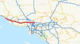
Ventura Freeway
Encyclopedia
The Ventura Freeway is a freeway in southern California
running from Ventura
to Pasadena
. It is the principal east-west route through Ventura County
and in the southern San Fernando Valley
in Los Angeles County
. From Ventura to its intersection with the Hollywood Freeway
in the southeastern San Fernando Valley in Los Angeles
(the Hollywood Split
), it is signed as U.S. Route 101 which was built in the late 1950s and opened on April 5, 1960. East of the Hollywood Freeway intersection, it is signed as State Route 134 which was built by 1971.
Prior to the construction of a new alignment in 1971, the portion east of the Golden State Freeway was known as the Colorado Freeway in reference to nearby Colorado Boulevard
, a historic thoroughfare in Pasadena and northeastern Los Angeles.
, which alternates between a freeway, an expressway
, and an ordinary divided highway previous to this point. East of this point, U.S. 101 is known as the Ventura Freeway. It travels eastward through the citrus orchards and strawberry fields of the Oxnard Plain
before ascending a short, steep pass into the Conejo Valley
. Continuing eastward through the northern Santa Monica Mountains
, it crosses the Ventura/Los Angeles county line before entering the San Fernando Valley. The freeway continues eastward along the valley's southern rim, crossing the 405
and 5 freeways and the Los Angeles River
. After passing through Downtown Glendale
south of the Verdugo Mountains
, it continues along the southern slope of the San Rafael Hills
between Glendale and Eagle Rock
before entering Pasadena near the Arroyo Seco
and terminating at the Foothill Freeway.
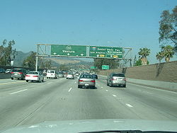
The Ventura Freeway suffers from severe congestion. Its intersection with the San Diego Freeway
, in Sherman Oaks
, is consistently rated as one of the five most congested interchanges in the nation. Where it meets the Hollywood Freeway at the Hollywood Split
junction, it is also notably congested. During events at the Rose Bowl
, the freeway's eastern portions often resemble a parking lot.
The east-west geographical alignment of the Ventura Freeway and the overall north-south (Washington-to-California
) designation of U.S. 101 on freeway signs can be confusing to visitors; the same freeway entrance can often be signed as "101 North" and "101 West"; this is most common in the San Fernando Valley
.
 State Route 134 is part of the California Freeway and Expressway System
.
The road is the main connector from the San Fernando Valley
and points north to the San Gabriel Valley
and points east. Presently, future Interstate 710 dead-ends at California Blvd and is signed as State Route 710. Residents of South Pasadena
have blocked efforts to extend Interstate 710 north to California Boulevard from its current end at Valley Boulevard north of Interstate 10 near the Alhambra
/Los Angeles
city limit. Signs on SR 134 and I-210 refer to the SR 710 stub in Pasadena as TO State Route 110, because exiting left from the Route 710 stub onto California Blvd and turning right on Arroyo Parkway will take you directly to SR 110, which is Pasadena's only direct freeway link to Downtown Los Angeles
.
The Interstate 5 offramp at Colorado St. is actually old SR 134, and there are still mileposts that refer to it as such. Old SR 134 followed Colorado St. through Glendale
and Colorado Boulevard in Eagle Rock
to the ramp connecting Colorado Boulevard and Figueroa Street to the Ventura Freeway. Old SR 134 continued onto the ramp and then onto what is presently the Ventura Freeway to Orange Grove Boulevard in Pasadena. The Colorado Boulevard
/Figueroa Street
ramps plus the segment of freeway between the ramps and just east of Orange Grove Boulevard were previously known as the Colorado Freeway.
Memorial Interchange". Autry's Museum of the American West
is located near the interchange in Griffith Park.
had a top 10 hit in 1972 with the song "Ventura Highway
" which the group said was about their dreams of moving to Southern California while living in Nebraska.
The song "A Sorta Fairytale
" by Tori Amos
begins with the line "On my way up north, up on the Ventura". Later in the song, Amos writes of the "Things you said that day
up on the 101."
Michael Jackson
wrote the song Billie Jean
while driving down the Ventura Freeway.
A dog, named Terry, who played Toto in the 1939 film, The Wizard of OZ, was buried in 1945 somewhere beneath today's Ventura Freeway.
line. This does not include the portion of Route 134 between Route 5 and Route 210 even though local usage extends the name over this portion of freeway. Starting at the 210 junction in Pasadena, highway signs indicate "Ventura" as the destination
.
Assembly Concurrent Resolution 54, Chapter 85 in 2003 also designated Route 101 in Ventura County
as the "Screaming Eagles Highway". This honors the 101st Airborne Division of the United States Army
, which formed on July 23, 1918 and subsequently has been involved in every major war that the United States has participated in since then.
This exit list proceeds from east to west, since the majority of the freeway is the north-south US 101.
{| class=wikitable
|-
!County
!Location
!Postmile
!Exit
!Destinations
!Notes
|-
|rowspan=41|Los Angeles
LA 134 R13.34-0.00
101 11.75-38.19
|rowspan=5|Pasadena
|R13.34
|
|
|Eastbound exit and westbound entrance
|-
|
|
|Fair Oaks Avenue, Marengo Avenue
|Eastbound exit and westbound entrance
|-
|R13.34
|13B
|
|Eastbound exit and westbound entrance
|-
|R13.34
|13B
|
|
|-
|R12.97
|13A
|Colorado Boulevard
, Orange Grove Boulevard
|Former SR 248
|-
| colspan="5" style="text-align:center;"|See State Route 134
|-
|rowspan=27|Los Angeles
|bgcolor=#ffdddd|0.86
|bgcolor=#ffdddd|1D
|bgcolor=#ffdddd|Cahuenga Boulevard – Hollywood
|bgcolor=#ffdddd|Signed as exit 1 eastbound; no westbound entrance
|-bgcolor=#ffdddd
|0.51
|1C
|Lankershim Boulevard
– North Hollywood
|Westbound exit and eastbound entrance
|-bgcolor=#ffdddd
|0.35
|
|Vineland Avenue
|No westbound exit
|-bgcolor=#ffdddd
|rowspan=3|134 0.00
101 11.75
|1B
|
|West/northbound exit and east/southbound entrance
|-
| colspan="3" style="text-align:center;"|West/north end of SR 134; east/south end of US 101 overlap
|-bgcolor=#ffdddd
|
|
|East/southbound exit and west/northbound entrance
|-bgcolor=#ffdddd
|11.83
|13A
|Tujunga Avenue
|Southbound exit and northbound entrance
|-
|12.85
|14
|Laurel Canyon Boulevard
– Studio City
|
|-
|13.88
|15
|Coldwater Canyon Avenue
|
|-
|14.89
|16
|Woodman Avenue
|
|-
|15.91
|17
|Van Nuys Boulevard
|
|-bgcolor=#ffdddd
|16.94
|18
|Sepulveda Boulevard
|Northbound exit and southbound entrance
|-
|17.17
|19A
|
|
|-bgcolor=#ffdddd
|17.50
|19B
|Haskell Avenue
|No southbound entrance
|-bgcolor=#ffdddd
|18.61
|20
|Hayvenhurst Avenue
|Northbound exit and southbound entrance
|-
|19.22
|21
|Balboa Boulevard
– Encino
|
|-
|20.23
|22
|White Oak Avenue
|
|-
|21.25
|23
|Reseda Boulevard
|
|-
|22.25
|24
|Tampa Avenue
|
|-
|23.26
|25
|Winnetka Avenue – Woodland Hills
|
|-
|24.31
|26A
|De Soto Avenue, Serrania Avenue
|Signed as exit 26 southbound
|-bgcolor=#ffdddd
|24.85
|26B
|Canoga Avenue
|Northbound exit and southbound entrance
|-
|25.34
|27
|
|Signed as exits 27A (north) and 27B (south) northbound
|-bgcolor=#ffdddd
|25.76
|27C
|Shoup Avenue
|Northbound exit and southbound entrance
|-bgcolor=#ffdddd
|26.45
|28
|Fallbrook Avenue
|Southbound exit only
|-bgcolor=#ffdddd
|26.86
|28
|Woodlake Avenue
|Northbound exit and entrance
|-
|27.36
|29
|Mulholland Drive
, Valley Circle Boulevard
|
|-
|rowspan=3|Calabasas
|28.29
|30
|Parkway Calabasas
|
|-
|31.06
|32
|Las Virgenes Road – Malibu Canyon
|
|-
|31.92
|33
|Lost Hills Road
|
|-
|rowspan=4|Agoura Hills
|32.79
|34
|Liberty Canyon Road
|
|-
|33.69
|35
|Chesebro Road – Agoura Hills
|
|-
|35.04
|36
|Kanan Road
|
|-
|36.18
|38
|Reyes Adobe Road
|
|-
|Westlake Village
|37.54
|39
|Lindero Canyon Road
|
|-
|rowspan=35|Ventura
VEN 0.00-R43.62
|rowspan=9|Thousand Oaks
| style="background:#dfd;"|0.70
| style="background:#dfd;"|40
| style="background:#dfd;"|
| style="background:#dfd;"|South end of SR 23 overlap
|-
|1.62
|41
|Hampshire Road
|
|-
|3.02
|43A
|Rancho Road
|Signed as exit 43B northbound
|- style="background:#dfd;"
|3.11
|43B
|
|North end of SR 23 overlap; signed as exit 43A northbound
|-
|4.06
|44
|Moorpark Road – Thousand Oaks
|
|-
|5.05
|45
|Lynn Road
|
|-
|6.19
|46
|Ventu Park Road – Newbury Park
|
|-
|7.02
|47A
|Rancho Conejo Boulevard, Borchard Road
|Signed as exits 47A (Rancho Conejo Boulevard) and 47B (Borchard Road) northbound
|-
|7.89
|47B
|Wendy Drive – Newbury Park
|Signed as exit 47C northbound
|-
|rowspan=7|Camarillo
|10.74
|50
|Camarillo Springs Road – Camarillo Grove County Park
|
|-
|12.30
|52
|Santa Rosa Road, Pleasant Valley Road
|
|-
|13.75
|53A
|Flynn Road, Dawson Drive
|
|-
|13.85
|53B
|
|
|-
|14.80
|54
|Carmen Drive – Camarillo
|
|-
|15.89
|55
|Las Posas Road
|
|-
|17.75
|57
|Central Avenue
|
|-
|rowspan=6|Oxnard
|19.17
|59
|Del Norte Boulevard
|
|-
|20.08
|60
|Santa Clara Avenue, Rice Avenue
|
|-
|21.01
|61
|Rose Avenue
|
|-
|22.01
|62A
|
|
|- style="background:#dfd;"
|22.73
|62B
|
|South end of SR 1 overlap
|-bgcolor=#ffdddd
|
|63A
|Wagon Wheel Road
|Southbound exit only
|-
|rowspan=10|Ventura
|R23.45
|63B
|Johnson Drive – Montalvo
|Signed as exit 63 northbound
|-
|R24.65
|64
|Victoria Avenue – Channel Islands Harbor
|
|-
|25.97
|65
|Telephone Road
|
|-bgcolor=#ffdddd
|26.39
|66A
|
|Signed as exit 66 southbound; no southbound entrance
|-bgcolor=#ffdddd
|26.72
|66B
|Main Street (US 101 Bus. north) – Ventura
|No southbound exit
|-
|28.45
|68
|Seaward Avenue
|
|-bgcolor=#ffdddd
|29.45
|69
|Vista del Mar Drive, Sanjon Road
|Northbound exit and southbound entrance
|-
|30.15
|70A
|California Street, Ventura Avenue
|
|-
|30.91
|70B
|
|
|-bgcolor=#ffdddd
|31.50
|71
|Main Street (US 101 Bus. south) – Ventura
|Southbound exit and northbound entrance
|-
|
| style="background:#dfd;"|R32.70
| style="background:#dfd;"|72
| style="background:#dfd;"|State Beaches (SR 1
north)
| style="background:#dfd;"|North end of SR 1 overlap; northbound exit and southbound entrance
|-
|
| style="background:#dfd;"|R38.98
| style="background:#dfd;"|78
| style="background:#dfd;"|Seacliff (SR 1
south)
| style="background:#dfd;"|South end of SR 1 overlap
|-
|
|T40.61
| colspan="3" style="text-align:center;"|North end of freeway
The entire route is in Los Angeles County
.
{| class=wikitable
|-
!Location
!Postmile
!Exit
!Destinations
!Notes
|-
|rowspan=5|Los Angeles
|bgcolor=#ffdddd|0.00
|bgcolor=#ffdddd|1A
|bgcolor=#ffdddd|
|bgcolor=#ffdddd|Westbound exit and eastbound entrance
|-bgcolor=#ffdddd
|0.00
|1B
|
|Westbound exit and eastbound entrance
|-bgcolor=#ffdddd
|
|
|Vineland Avenue
|Eastbound exit and entrance only
|-bgcolor=#ffdddd
|0.51
|1C
|Lankershim Boulevard
– North Hollywood
|Westbound exit and eastbound entrance
|-bgcolor=#ffdddd
|0.86
|1D
|Cahuenga Boulevard
|Signed as exit 1 eastbound; no westbound entrance
|-
|rowspan=3|Burbank
|bgcolor=#ffdddd|1.82
|bgcolor=#ffdddd|2
|bgcolor=#ffdddd|Pass Avenue – Burbank
|bgcolor=#ffdddd|Eastbound exit only
|-bgcolor=#ffdddd
|2.11
|2
|Hollywood Way
|No eastbound exit
|-
|2.90
|3
|Bob Hope Drive, Buena Vista Street
|
|-
|rowspan=2|Los Angeles
|3.81
|4
|Forest Lawn Drive
|
|-bgcolor=#ffdddd
|4.81
|5A
|Victory Boulevard
|Eastbound exit and westbound entrance
|-
|rowspan=8|Glendale
|R5.47
|5B
|
|Signed as exit 5 westbound
|-
|R5.47
|5
|, Burbank Airport
|Eastbound exit is via exit 5A
|-
|R6.18
|6
|San Fernando Road
|
|-
|R6.57
|7A
|Pacific Avenue
|
|-
|R6.96-
R7.13
|7B
|Central Avenue, Brand Boulevard
|
|-
|R7.87
|8
|Glendale Avenue
|
|-
|R8.81
|9A
|Harvey Drive
|Signed as exit 9B eastbound
|-
|R8.96
|9B
|
|Signed as exit 9A eastbound
|-
|Los Angeles
|R11.44
|11
|Figueroa Street
, Colorado Boulevard
|Figueroa Street was former SR 159 south; Colorado Boulevard was former SR 248 east; westbound exit and eastbound entrance for Colorado Boulevard only
|-
|rowspan=6|Pasadena
|R12.36
|12
|San Rafael Avenue, Linda Vista Avenue
|Linda Vista Avenue was former SR 159 north
|-
|R12.97
|13A
|Colorado Boulevard
, Orange Grove Boulevard
|Colorado Boulevard was former SR 248 west
|-bgcolor=#ffdddd
|R13.34
|13B
|
|Eastbound exit and westbound entrance; former SR 118
west
|-
|R13.34
|13B
| Del Mar Boulevard, California Boulevard (SR 710 south) to SR 110 south
|No exit number westbound
|-bgcolor=#ffdddd
|
|
|Fair Oaks Avenue, Marengo Avenue
|Eastbound exit and westbound entrance
|-bgcolor=#ffdddd
|
|
|
|Eastbound exit and westbound entrance
California
California is a state located on the West Coast of the United States. It is by far the most populous U.S. state, and the third-largest by land area...
running from Ventura
Ventura, California
Ventura is the county seat of Ventura County, California, United States, incorporated in 1866. The population was 106,433 at the 2010 census, up from 100,916 at the 2000 census. Ventura is accessible via U.S...
to Pasadena
Pasadena, California
Pasadena is a city in Los Angeles County, California, United States. Although famous for hosting the annual Rose Bowl football game and Tournament of Roses Parade, Pasadena is the home to many scientific and cultural institutions, including the California Institute of Technology , the Jet...
. It is the principal east-west route through Ventura County
Ventura County, California
Ventura County is a county in the southern part of the U.S. state of California. It is located on California's Pacific coast. It is often referred to as the Gold Coast, and has a reputation of being one of the safest populated places and one of the most affluent places in the country...
and in the southern San Fernando Valley
San Fernando Valley
The San Fernando Valley is an urbanized valley located in the Los Angeles metropolitan area of southern California, United States, defined by the dramatic mountains of the Transverse Ranges circling it...
in Los Angeles County
Los Angeles County, California
Los Angeles County is a county in the U.S. state of California. As of 2010 U.S. Census, the county had a population of 9,818,605, making it the most populous county in the United States. Los Angeles County alone is more populous than 42 individual U.S. states...
. From Ventura to its intersection with the Hollywood Freeway
Hollywood Freeway
The Hollywood Freeway is one of the principal freeways of Los Angeles, California and one of the busiest in the United States. It is the principal route over the Cahuenga Pass, the primary shortcut between the Los Angeles Basin and the San Fernando Valley...
in the southeastern San Fernando Valley in Los Angeles
Los Angeles, California
Los Angeles , with a population at the 2010 United States Census of 3,792,621, is the most populous city in California, USA and the second most populous in the United States, after New York City. It has an area of , and is located in Southern California...
(the Hollywood Split
Hollywood Split
The Hollywood Split is a freeway interchange in the San Fernando Valley area of Los Angeles, California...
), it is signed as U.S. Route 101 which was built in the late 1950s and opened on April 5, 1960. East of the Hollywood Freeway intersection, it is signed as State Route 134 which was built by 1971.
Prior to the construction of a new alignment in 1971, the portion east of the Golden State Freeway was known as the Colorado Freeway in reference to nearby Colorado Boulevard
Colorado Boulevard
Colorado Boulevard is a major east–west street in Southern California, United States. It runs from Griffith Park in Los Angeles east through Glendale, the Eagle Rock section of Los Angeles, Pasadena, and Arcadia, ending in Monrovia...
, a historic thoroughfare in Pasadena and northeastern Los Angeles.
Route description
The freeway begins southeast of La ConchitaLa Conchita, California
La Conchita is a small unincorporated community in western Ventura County, California, on U.S. Route 101 just southeast of the Santa Barbara county line...
, which alternates between a freeway, an expressway
Limited-access road
A limited-access road known by various terms worldwide, including limited-access highway, dual-carriageway and expressway, is a highway or arterial road for high-speed traffic which has many or most characteristics of a controlled-access highway , including limited or no access to adjacent...
, and an ordinary divided highway previous to this point. East of this point, U.S. 101 is known as the Ventura Freeway. It travels eastward through the citrus orchards and strawberry fields of the Oxnard Plain
Oxnard Plain
The Oxnard Plain is a large coastal plain in southwest Ventura County, California bounded by the Santa Monica Mountains, the Santa Susana Mountains, and Oak Ridge to the east, the Topatopa Mountains to the north, the Santa Clara River Valley to the northeast and the Pacific Ocean to the south and...
before ascending a short, steep pass into the Conejo Valley
Conejo Valley
The Conejo Valley is a region spanning both southeastern Ventura County and northwestern Los Angeles County in Southern California, United States...
. Continuing eastward through the northern Santa Monica Mountains
Santa Monica Mountains
The Santa Monica Mountains are a Transverse Range in Southern California, along the coast of the Pacific Ocean in the United States.-Geography:...
, it crosses the Ventura/Los Angeles county line before entering the San Fernando Valley. The freeway continues eastward along the valley's southern rim, crossing the 405
Interstate 405 (California)
Interstate 405 is a major north–south Interstate Highway in Southern California. It is a bypass of Interstate 5, running along the western areas of the Greater Los Angeles Area from Irvine in the south to near San Fernando in the north...
and 5 freeways and the Los Angeles River
Los Angeles River
The Los Angeles River is a river that starts in the San Fernando Valley, in the Simi Hills and Santa Susana Mountains, and flows through Los Angeles County, California, from Canoga Park in the western end of the San Fernando Valley, nearly southeast to its mouth in Long Beach...
. After passing through Downtown Glendale
Glendale, California
Glendale is a city in Los Angeles County, California, United States. As of the 2010 Census, the city population is 191,719, down from 194,973 at the 2000 census. making it the third largest city in Los Angeles County and the 22nd largest city in the state of California...
south of the Verdugo Mountains
Verdugo Mountains
The Verdugo Mountains are a small, rugged mountain range of the Transverse Ranges system, located just south of the western San Gabriel Mountains in Los Angeles County, Southern California...
, it continues along the southern slope of the San Rafael Hills
San Rafael Hills
The San Rafael Hills are a mountain range in Los Angeles County, California. They are one of the lower Transverse Ranges, and are parallel to and below the San Gabriel Mountains to the south, adjacent to the San Gabriel Valley overlooking the Los Angeles Basin.-Geography:The Hills contain all or...
between Glendale and Eagle Rock
Eagle Rock, Los Angeles, California
In 1909, Hill Avenue, now Hill Drive, was one of Eagle Rock's most beautiful streets. Other streets were Royal Drive , Acacia Street , Kenilworth Avenue , Highland Avenue , and Fairmont Avenue...
before entering Pasadena near the Arroyo Seco
Arroyo Seco (Los Angeles County)
The Arroyo Seco, meaning "dry stream" in Spanish, is a seasonal river, canyon, watershed, and cultural area in Los Angeles County, California, United States. The Arroyo Seco has been called the most celebrated canyon in Southern California.-River course:...
and terminating at the Foothill Freeway.
The Ventura Freeway suffers from severe congestion. Its intersection with the San Diego Freeway
Interstate 405 (California)
Interstate 405 is a major north–south Interstate Highway in Southern California. It is a bypass of Interstate 5, running along the western areas of the Greater Los Angeles Area from Irvine in the south to near San Fernando in the north...
, in Sherman Oaks
Sherman Oaks, Los Angeles, California
Sherman Oaks is an affluent district in the San Fernando Valley area of the city of Los Angeles, California. In contrast to much of the Valley, the area is relatively urbanized, with commercial skyscrapers along Ventura Boulevard as well as scattered throughout...
, is consistently rated as one of the five most congested interchanges in the nation. Where it meets the Hollywood Freeway at the Hollywood Split
Hollywood Split
The Hollywood Split is a freeway interchange in the San Fernando Valley area of Los Angeles, California...
junction, it is also notably congested. During events at the Rose Bowl
Rose Bowl (stadium)
The Rose Bowl is an outdoor athletic stadium in Pasadena, California, U.S., in Los Angeles County. The stadium is the site of the annual college football bowl game, the Rose Bowl, held on New Year's Day. In 1982, it became the home field of the UCLA Bruins college football team of the Pac-12...
, the freeway's eastern portions often resemble a parking lot.
The east-west geographical alignment of the Ventura Freeway and the overall north-south (Washington-to-California
California
California is a state located on the West Coast of the United States. It is by far the most populous U.S. state, and the third-largest by land area...
) designation of U.S. 101 on freeway signs can be confusing to visitors; the same freeway entrance can often be signed as "101 North" and "101 West"; this is most common in the San Fernando Valley
San Fernando Valley
The San Fernando Valley is an urbanized valley located in the Los Angeles metropolitan area of southern California, United States, defined by the dramatic mountains of the Transverse Ranges circling it...
.
California State Route 134
California Freeway and Expressway System
The California Freeway and Expressway System is a system of existing or planned freeways and expressways in the U.S. state of California. It is defined by the Streets and Highways Code.-List of roads in the system:*State Route 1 *State Route 2...
.
The road is the main connector from the San Fernando Valley
San Fernando Valley
The San Fernando Valley is an urbanized valley located in the Los Angeles metropolitan area of southern California, United States, defined by the dramatic mountains of the Transverse Ranges circling it...
and points north to the San Gabriel Valley
San Gabriel Valley
The San Gabriel Valley is one of the principal valleys of Southern California, United States. It lies to the east of Los Angeles, to the north of the Puente Hills, to the south of the San Gabriel Mountains, and west of the Inland Empire. It derives its name from the San Gabriel River that flows...
and points east. Presently, future Interstate 710 dead-ends at California Blvd and is signed as State Route 710. Residents of South Pasadena
South Pasadena, California
South Pasadena is a city in Los Angeles County, California, United States. As of the 2010 census, it had a population of 25,619, up from 24,292 at the 2000 census. It is located in in the West San Gabriel Valley...
have blocked efforts to extend Interstate 710 north to California Boulevard from its current end at Valley Boulevard north of Interstate 10 near the Alhambra
Alhambra, California
Alhambra is a city located in the western San Gabriel Valley region of Los Angeles County, California, United States, which is approximately eight miles from the Downtown Los Angeles civic center. As of the 2010 census, the population was 83,089, down from 85,804 at the 2000 census. The city's...
/Los Angeles
Los Angeles, California
Los Angeles , with a population at the 2010 United States Census of 3,792,621, is the most populous city in California, USA and the second most populous in the United States, after New York City. It has an area of , and is located in Southern California...
city limit. Signs on SR 134 and I-210 refer to the SR 710 stub in Pasadena as TO State Route 110, because exiting left from the Route 710 stub onto California Blvd and turning right on Arroyo Parkway will take you directly to SR 110, which is Pasadena's only direct freeway link to Downtown Los Angeles
Downtown Los Angeles
Downtown Los Angeles is the central business district of Los Angeles, California, United States, located close to the geographic center of the metropolitan area...
.
The Interstate 5 offramp at Colorado St. is actually old SR 134, and there are still mileposts that refer to it as such. Old SR 134 followed Colorado St. through Glendale
Glendale, California
Glendale is a city in Los Angeles County, California, United States. As of the 2010 Census, the city population is 191,719, down from 194,973 at the 2000 census. making it the third largest city in Los Angeles County and the 22nd largest city in the state of California...
and Colorado Boulevard in Eagle Rock
Eagle Rock, Los Angeles, California
In 1909, Hill Avenue, now Hill Drive, was one of Eagle Rock's most beautiful streets. Other streets were Royal Drive , Acacia Street , Kenilworth Avenue , Highland Avenue , and Fairmont Avenue...
to the ramp connecting Colorado Boulevard and Figueroa Street to the Ventura Freeway. Old SR 134 continued onto the ramp and then onto what is presently the Ventura Freeway to Orange Grove Boulevard in Pasadena. The Colorado Boulevard
Colorado Boulevard
Colorado Boulevard is a major east–west street in Southern California, United States. It runs from Griffith Park in Los Angeles east through Glendale, the Eagle Rock section of Los Angeles, Pasadena, and Arcadia, ending in Monrovia...
/Figueroa Street
Figueroa Street
Figueroa Street is a street in Los Angeles County, California named for General José Figueroa , governor of Alta California from 1833 to 1835, who oversaw the secularization of the missions of California...
ramps plus the segment of freeway between the ramps and just east of Orange Grove Boulevard were previously known as the Colorado Freeway.
History
The interchange of SR 134 and Interstate 5 is dedicated "Gene AutryGene Autry
Orvon Grover Autry , better known as Gene Autry, was an American performer who gained fame as The Singing Cowboy on the radio, in movies and on television for more than three decades beginning in the 1930s...
Memorial Interchange". Autry's Museum of the American West
Autry National Center
The Autry National Center of the American West is an intercultural center and museum in Los Angeles, California that celebrates the diversity and history of the American West through three important institutions: the Southwest Museum of the American Indian, the Museum of the American West, and the...
is located near the interchange in Griffith Park.
In popular culture
The group AmericaAmerica (band)
America is an English-American folk rock band that originally included members Gerry Beckley, Dewey Bunnell and Dan Peek. The three members were barely out of their teens when they became a musical sensation during 1972, scoring #1 hits and winning a Grammy for best new musical artist...
had a top 10 hit in 1972 with the song "Ventura Highway
Ventura Highway
"Ventura Highway" is a popular 1972 song by the rock 'n' roll band America from its album, Homecoming.-Background:The vocalist and writer of the song Dewey Bunnell has said that the lyric "alligator lizards in the air" in the song is a reference to the shapes of clouds in the sky...
" which the group said was about their dreams of moving to Southern California while living in Nebraska.
The song "A Sorta Fairytale
A Sorta Fairytale
"A Sorta Fairytale" is a song written and performed by singer-songwriter Tori Amos. It was released as the first single from her 2002 album Scarlet's Walk. The song reached #14 on the Billboard Bubbling Under Hot 100 Singles chart, and #1 on the Triple A chart...
" by Tori Amos
Tori Amos
Tori Amos is an American pianist, singer-songwriter and composer. She was at the forefront of a number of female singer-songwriters in the early 1990s and was noteworthy early in her career as one of the few alternative rock performers to use a piano as her primary instrument...
begins with the line "On my way up north, up on the Ventura". Later in the song, Amos writes of the "Things you said that day
up on the 101."
Michael Jackson
Michael Jackson
Michael Joseph Jackson was an American recording artist, entertainer, and businessman. Referred to as the King of Pop, or by his initials MJ, Jackson is recognized as the most successful entertainer of all time by Guinness World Records...
wrote the song Billie Jean
Billie Jean
"Billie Jean" is a dance-pop/R&B song by American recording artist Michael Jackson. It was written, composed, and co-produced by Jackson, and produced by Quincy Jones from the singer's sixth album, Thriller . Originally disliked by Jones, the track was almost removed from the album after he and...
while driving down the Ventura Freeway.
A dog, named Terry, who played Toto in the 1939 film, The Wizard of OZ, was buried in 1945 somewhere beneath today's Ventura Freeway.
Legal definition
The Ventura Freeway is Routes 101 and 134 from Route 5 to the Santa Barbara CountySanta Barbara County, California
Santa Barbara County is a county located in the southern portion of the U.S. state of California, on the Pacific coast. As of 2010 the county had a population of 423,895. The county seat is Santa Barbara and the largest city is Santa Maria.-History:...
line. This does not include the portion of Route 134 between Route 5 and Route 210 even though local usage extends the name over this portion of freeway. Starting at the 210 junction in Pasadena, highway signs indicate "Ventura" as the destination
Control city
A control city is a city or locality posted on a traffic sign indicating forward destinations on a certain route. These destinations aid motorists using the highway system to reach destinations along the various routes...
.
Assembly Concurrent Resolution 54, Chapter 85 in 2003 also designated Route 101 in Ventura County
Ventura County, California
Ventura County is a county in the southern part of the U.S. state of California. It is located on California's Pacific coast. It is often referred to as the Gold Coast, and has a reputation of being one of the safest populated places and one of the most affluent places in the country...
as the "Screaming Eagles Highway". This honors the 101st Airborne Division of the United States Army
United States Army
The United States Army is the main branch of the United States Armed Forces responsible for land-based military operations. It is the largest and oldest established branch of the U.S. military, and is one of seven U.S. uniformed services...
, which formed on July 23, 1918 and subsequently has been involved in every major war that the United States has participated in since then.
Exit list
- Note: Except where prefixed with a letter, postmiles were measured in 1964, based on the alignment as it existed at that time, and do not necessarily reflect current mileage. The numbers reset at county lines; the start and end postmiles in each county are given in the county column.
This exit list proceeds from east to west, since the majority of the freeway is the north-south US 101.
{| class=wikitable
|-
!County
!Location
!Postmile
!Exit
Exit number
An exit number is a number assigned to a road junction, usually an exit from a freeway. It is usually marked on the same sign as the destinations of the exit, as well as a sign in the gore....
!Destinations
!Notes
|-
|rowspan=41|Los Angeles
Los Angeles County, California
Los Angeles County is a county in the U.S. state of California. As of 2010 U.S. Census, the county had a population of 9,818,605, making it the most populous county in the United States. Los Angeles County alone is more populous than 42 individual U.S. states...
LA 134 R13.34-0.00
101 11.75-38.19
|rowspan=5|Pasadena
Pasadena, California
Pasadena is a city in Los Angeles County, California, United States. Although famous for hosting the annual Rose Bowl football game and Tournament of Roses Parade, Pasadena is the home to many scientific and cultural institutions, including the California Institute of Technology , the Jet...
|R13.34
|
|
|Eastbound exit and westbound entrance
|-
|
|
|Fair Oaks Avenue, Marengo Avenue
|Eastbound exit and westbound entrance
|-
|R13.34
|13B
|
|Eastbound exit and westbound entrance
|-
|R13.34
|13B
|
|
|-
|R12.97
|13A
|Colorado Boulevard
Colorado Boulevard
Colorado Boulevard is a major east–west street in Southern California, United States. It runs from Griffith Park in Los Angeles east through Glendale, the Eagle Rock section of Los Angeles, Pasadena, and Arcadia, ending in Monrovia...
, Orange Grove Boulevard
|Former SR 248
|-
| colspan="5" style="text-align:center;"|See State Route 134
|-
|rowspan=27|Los Angeles
Los Angeles, California
Los Angeles , with a population at the 2010 United States Census of 3,792,621, is the most populous city in California, USA and the second most populous in the United States, after New York City. It has an area of , and is located in Southern California...
|bgcolor=#ffdddd|0.86
|bgcolor=#ffdddd|1D
|bgcolor=#ffdddd|Cahuenga Boulevard – Hollywood
|bgcolor=#ffdddd|Signed as exit 1 eastbound; no westbound entrance
|-bgcolor=#ffdddd
|0.51
|1C
|Lankershim Boulevard
Lankershim Boulevard
-Geography:Lankershim Boulevard starts off at San Fernando Road in the Sun Valley portion of the San Fernando Valley. In addition to Sun Valley, it runs through North Hollywood and Universal City. It runs for about 7.3 miles before ending directly south of Ventura Boulevard...
– North Hollywood
|Westbound exit and eastbound entrance
|-bgcolor=#ffdddd
|0.35
|
|Vineland Avenue
|No westbound exit
|-bgcolor=#ffdddd
|rowspan=3|134 0.00
101 11.75
|1B
|
|West/northbound exit and east/southbound entrance
|-
| colspan="3" style="text-align:center;"|West/north end of SR 134; east/south end of US 101 overlap
|-bgcolor=#ffdddd
|
|
|East/southbound exit and west/northbound entrance
|-bgcolor=#ffdddd
|11.83
|13A
|Tujunga Avenue
|Southbound exit and northbound entrance
|-
|12.85
|14
|Laurel Canyon Boulevard
Laurel Canyon Boulevard
Laurel Canyon Boulevard is a major street in the city of Los Angeles, California. It starts off at Polk Street in Sylmar in the northern San Fernando Valley near the junction of the San Diego and the Golden State ) freeways. Laurel Canyon Boulevard bypasses the city of San Fernando to the west,...
– Studio City
|
|-
|13.88
|15
|Coldwater Canyon Avenue
|
|-
|14.89
|16
|Woodman Avenue
|
|-
|15.91
|17
|Van Nuys Boulevard
Van Nuys Boulevard
Van Nuys Boulevard is a major north-south arterial road that runs through the central San Fernando Valley of Los Angeles County, California. The boulevard was notable for its cruising lifestyle that was prevalent in the 1960s and '70s, which was depicted in the 1979 film Van Nuys Blvd..-The...
|
|-bgcolor=#ffdddd
|16.94
|18
|Sepulveda Boulevard
Sepulveda Boulevard
Sepulveda Boulevard is a street in Los Angeles, California, which stretches some 42.8 miles from Rinaldi Street at the north end of the San Fernando Valley to the city limits of Hermosa Beach, where it "jumps" east and continues on to Long Beach. It generally runs north-south, passing underneath...
|Northbound exit and southbound entrance
|-
|17.17
|19A
|
|
|-bgcolor=#ffdddd
|17.50
|19B
|Haskell Avenue
|No southbound entrance
|-bgcolor=#ffdddd
|18.61
|20
|Hayvenhurst Avenue
|Northbound exit and southbound entrance
|-
|19.22
|21
|Balboa Boulevard
Balboa Boulevard
Balboa Boulevard is a major north-south street in the city of Los Angeles, California, and it cuts through many communities and is one of the main thoroughfares in the San Fernando Valley....
– Encino
|
|-
|20.23
|22
|White Oak Avenue
|
|-
|21.25
|23
|Reseda Boulevard
Reseda Boulevard
Reseda Boulevard is a major north-south arterial road that runs through the western San Fernando Valley of Los Angeles County, California.Reseda Boulevard runs approximately from the Santa Monica Mountains at the Marvin Braude Mulholland Gateway Park in the south to the Santa Susana Mountains and...
|
|-
|22.25
|24
|Tampa Avenue
|
|-
|23.26
|25
|Winnetka Avenue – Woodland Hills
|
|-
|24.31
|26A
|De Soto Avenue, Serrania Avenue
|Signed as exit 26 southbound
|-bgcolor=#ffdddd
|24.85
|26B
|Canoga Avenue
|Northbound exit and southbound entrance
|-
|25.34
|27
|
|Signed as exits 27A (north) and 27B (south) northbound
|-bgcolor=#ffdddd
|25.76
|27C
|Shoup Avenue
|Northbound exit and southbound entrance
|-bgcolor=#ffdddd
|26.45
|28
|Fallbrook Avenue
|Southbound exit only
|-bgcolor=#ffdddd
|26.86
|28
|Woodlake Avenue
|Northbound exit and entrance
|-
|27.36
|29
|Mulholland Drive
Mulholland Drive
Mulholland Drive is a street and road in the eastern Santa Monica Mountains of Southern California. It is named after Los Angeles pioneer civil engineer William Mulholland...
, Valley Circle Boulevard
|
|-
|rowspan=3|Calabasas
Calabasas, California
Calabasas is an affluent city in Los Angeles County, California in the western United States. It is located in the hills in the southwestern San Fernando Valley and the Santa Monica Mountains between Woodland Hills, Agoura Hills, West Hills, and Malibu, California. As of the 2010 census, the city...
|28.29
|30
|Parkway Calabasas
|
|-
|31.06
|32
|Las Virgenes Road – Malibu Canyon
|
|-
|31.92
|33
|Lost Hills Road
|
|-
|rowspan=4|Agoura Hills
Agoura Hills, California
Agoura Hills is a city in Los Angeles County, California, and has the ZIP code 91301. The population was 20,330 at the 2010 census, down from 20,537 at the 2000 census. It is located in the eastern Conejo Valley between the Simi Hills and the Santa Monica Mountains. This city on the Ventura...
|32.79
|34
|Liberty Canyon Road
|
|-
|33.69
|35
|Chesebro Road – Agoura Hills
Agoura Hills, California
Agoura Hills is a city in Los Angeles County, California, and has the ZIP code 91301. The population was 20,330 at the 2010 census, down from 20,537 at the 2000 census. It is located in the eastern Conejo Valley between the Simi Hills and the Santa Monica Mountains. This city on the Ventura...
|
|-
|35.04
|36
|Kanan Road
|
|-
|36.18
|38
|Reyes Adobe Road
|
|-
|Westlake Village
Westlake Village, California
Westlake Village is a planned community that straddles the Los Angeles and Ventura county line. The eastern portion is the incorporated city Westlake Village, located on the western edge of Los Angeles County, California. The city, located in the region known as the Conejo Valley, encompasses half...
|37.54
|39
|Lindero Canyon Road
|
|-
|rowspan=35|Ventura
Ventura County, California
Ventura County is a county in the southern part of the U.S. state of California. It is located on California's Pacific coast. It is often referred to as the Gold Coast, and has a reputation of being one of the safest populated places and one of the most affluent places in the country...
VEN 0.00-R43.62
|rowspan=9|Thousand Oaks
Thousand Oaks, California
Thousand Oaks is a city in southeastern Ventura County, California, in the United States. It was named after the many oak trees that grace the area, and the city seal is adorned with an oak....
| style="background:#dfd;"|0.70
| style="background:#dfd;"|40
| style="background:#dfd;"|
| style="background:#dfd;"|South end of SR 23 overlap
|-
|1.62
|41
|Hampshire Road
|
|-
|3.02
|43A
|Rancho Road
|Signed as exit 43B northbound
|- style="background:#dfd;"
|3.11
|43B
|
|North end of SR 23 overlap; signed as exit 43A northbound
|-
|4.06
|44
|Moorpark Road – Thousand Oaks
Thousand Oaks, California
Thousand Oaks is a city in southeastern Ventura County, California, in the United States. It was named after the many oak trees that grace the area, and the city seal is adorned with an oak....
|
|-
|5.05
|45
|Lynn Road
|
|-
|6.19
|46
|Ventu Park Road – Newbury Park
Newbury Park, California
The community of Newbury Park, California is located in the western portion of the city of Thousand Oaks and Casa Conejo, an unincorporated area of southeastern Ventura County's Conejo Valley, which is also in the northwestern Greater Los Angeles Area...
|
|-
|7.02
|47A
|Rancho Conejo Boulevard, Borchard Road
|Signed as exits 47A (Rancho Conejo Boulevard) and 47B (Borchard Road) northbound
|-
|7.89
|47B
|Wendy Drive – Newbury Park
Newbury Park, California
The community of Newbury Park, California is located in the western portion of the city of Thousand Oaks and Casa Conejo, an unincorporated area of southeastern Ventura County's Conejo Valley, which is also in the northwestern Greater Los Angeles Area...
|Signed as exit 47C northbound
|-
|rowspan=7|Camarillo
Camarillo, California
Camarillo is a city in Ventura County, California, United States. The population was 65,201 at the 2010 census, up from 57,084 at the 2000 census. The Ventura Freeway Camarillo is a city in Ventura County, California, United States. The population was 65,201 at the 2010 census, up from 57,084 at...
|10.74
|50
|Camarillo Springs Road – Camarillo Grove County Park
|
|-
|12.30
|52
|Santa Rosa Road, Pleasant Valley Road
|
|-
|13.75
|53A
|Flynn Road, Dawson Drive
|
|-
|13.85
|53B
|
|
|-
|14.80
|54
|Carmen Drive – Camarillo
Camarillo, California
Camarillo is a city in Ventura County, California, United States. The population was 65,201 at the 2010 census, up from 57,084 at the 2000 census. The Ventura Freeway Camarillo is a city in Ventura County, California, United States. The population was 65,201 at the 2010 census, up from 57,084 at...
|
|-
|15.89
|55
|Las Posas Road
|
|-
|17.75
|57
|Central Avenue
|
|-
|rowspan=6|Oxnard
Oxnard, California
Oxnard is the 113th largest city in the United States, 19th largest city in California and largest city in Ventura County, California, by way of population. It is located at the western edge of the fertile Oxnard Plain, and is an important agricultural center, with its distinction as the...
|19.17
|59
|Del Norte Boulevard
|
|-
|20.08
|60
|Santa Clara Avenue, Rice Avenue
|
|-
|21.01
|61
|Rose Avenue
|
|-
|22.01
|62A
|
|
|- style="background:#dfd;"
|22.73
|62B
|
|South end of SR 1 overlap
|-bgcolor=#ffdddd
|
|63A
|Wagon Wheel Road
|Southbound exit only
|-
|rowspan=10|Ventura
Ventura, California
Ventura is the county seat of Ventura County, California, United States, incorporated in 1866. The population was 106,433 at the 2010 census, up from 100,916 at the 2000 census. Ventura is accessible via U.S...
|R23.45
|63B
|Johnson Drive – Montalvo
|Signed as exit 63 northbound
|-
|R24.65
|64
|Victoria Avenue – Channel Islands Harbor
|
|-
|25.97
|65
|Telephone Road
|
|-bgcolor=#ffdddd
|26.39
|66A
|
|Signed as exit 66 southbound; no southbound entrance
|-bgcolor=#ffdddd
|26.72
|66B
|Main Street (US 101 Bus. north) – Ventura
Ventura, California
Ventura is the county seat of Ventura County, California, United States, incorporated in 1866. The population was 106,433 at the 2010 census, up from 100,916 at the 2000 census. Ventura is accessible via U.S...
|No southbound exit
|-
|28.45
|68
|Seaward Avenue
|
|-bgcolor=#ffdddd
|29.45
|69
|Vista del Mar Drive, Sanjon Road
|Northbound exit and southbound entrance
|-
|30.15
|70A
|California Street, Ventura Avenue
|
|-
|30.91
|70B
|
|
|-bgcolor=#ffdddd
|31.50
|71
|Main Street (US 101 Bus. south) – Ventura
Ventura, California
Ventura is the county seat of Ventura County, California, United States, incorporated in 1866. The population was 106,433 at the 2010 census, up from 100,916 at the 2000 census. Ventura is accessible via U.S...
|Southbound exit and northbound entrance
|-
|
| style="background:#dfd;"|R32.70
| style="background:#dfd;"|72
| style="background:#dfd;"|State Beaches (SR 1
California State Route 1
State Route 1 , more often called Highway 1, is a state highway that runs along much of the Pacific coast of the U.S. state of California. It is famous for running along some of the most beautiful coastlines in the world, leading to its designation as an All-American Road.Highway 1 does not run...
north)
| style="background:#dfd;"|North end of SR 1 overlap; northbound exit and southbound entrance
|-
|
| style="background:#dfd;"|R38.98
| style="background:#dfd;"|78
| style="background:#dfd;"|Seacliff (SR 1
California State Route 1
State Route 1 , more often called Highway 1, is a state highway that runs along much of the Pacific coast of the U.S. state of California. It is famous for running along some of the most beautiful coastlines in the world, leading to its designation as an All-American Road.Highway 1 does not run...
south)
| style="background:#dfd;"|South end of SR 1 overlap
|-
|
|T40.61
| colspan="3" style="text-align:center;"|North end of freeway
On State Route 134
- Note: Except where prefixed with a letter, postmiles were measured in 1964, based on the alignment as it existed at that time, and do not necessarily reflect current mileage.
The entire route is in Los Angeles County
Los Angeles County, California
Los Angeles County is a county in the U.S. state of California. As of 2010 U.S. Census, the county had a population of 9,818,605, making it the most populous county in the United States. Los Angeles County alone is more populous than 42 individual U.S. states...
.
{| class=wikitable
|-
!Location
!Postmile
!Exit
Exit number
An exit number is a number assigned to a road junction, usually an exit from a freeway. It is usually marked on the same sign as the destinations of the exit, as well as a sign in the gore....
!Destinations
!Notes
|-
|rowspan=5|Los Angeles
Los Angeles, California
Los Angeles , with a population at the 2010 United States Census of 3,792,621, is the most populous city in California, USA and the second most populous in the United States, after New York City. It has an area of , and is located in Southern California...
|bgcolor=#ffdddd|0.00
|bgcolor=#ffdddd|1A
|bgcolor=#ffdddd|
|bgcolor=#ffdddd|Westbound exit and eastbound entrance
|-bgcolor=#ffdddd
|0.00
|1B
|
|Westbound exit and eastbound entrance
|-bgcolor=#ffdddd
|
|
|Vineland Avenue
Vineland Avenue
Vineland Avenue is a major north-south thoroughfare in the San Fernando Valley.-Geography:Vineland Avenue begins as a continuation of Sunland Boulevard south of San Fernando Road in Sun Valley...
|Eastbound exit and entrance only
|-bgcolor=#ffdddd
|0.51
|1C
|Lankershim Boulevard
Lankershim Boulevard
-Geography:Lankershim Boulevard starts off at San Fernando Road in the Sun Valley portion of the San Fernando Valley. In addition to Sun Valley, it runs through North Hollywood and Universal City. It runs for about 7.3 miles before ending directly south of Ventura Boulevard...
– North Hollywood
|Westbound exit and eastbound entrance
|-bgcolor=#ffdddd
|0.86
|1D
|Cahuenga Boulevard
|Signed as exit 1 eastbound; no westbound entrance
|-
|rowspan=3|Burbank
Burbank, California
Burbank is a city in Los Angeles County in Southern California, United States, north of downtown Los Angeles. The estimated population in 2010 was 103,340....
|bgcolor=#ffdddd|1.82
|bgcolor=#ffdddd|2
|bgcolor=#ffdddd|Pass Avenue – Burbank
Burbank, California
Burbank is a city in Los Angeles County in Southern California, United States, north of downtown Los Angeles. The estimated population in 2010 was 103,340....
|bgcolor=#ffdddd|Eastbound exit only
|-bgcolor=#ffdddd
|2.11
|2
|Hollywood Way
|No eastbound exit
|-
|2.90
|3
|Bob Hope Drive, Buena Vista Street
|
|-
|rowspan=2|Los Angeles
Los Angeles, California
Los Angeles , with a population at the 2010 United States Census of 3,792,621, is the most populous city in California, USA and the second most populous in the United States, after New York City. It has an area of , and is located in Southern California...
|3.81
|4
|Forest Lawn Drive
|
|-bgcolor=#ffdddd
|4.81
|5A
|Victory Boulevard
Victory Boulevard (Los Angeles)
Victory Boulevard is a major east-west arterial road that runs traversing the entire length of the San Fernando Valley in Los Angeles County. Through much of the San Fernando Valley, Victory Boulevard divides the affluent communities at the southern end of the Valley , from the less affluent...
|Eastbound exit and westbound entrance
|-
|rowspan=8|Glendale
Glendale, California
Glendale is a city in Los Angeles County, California, United States. As of the 2010 Census, the city population is 191,719, down from 194,973 at the 2000 census. making it the third largest city in Los Angeles County and the 22nd largest city in the state of California...
|R5.47
|5B
|
|Signed as exit 5 westbound
|-
|R5.47
|5
|, Burbank Airport
|Eastbound exit is via exit 5A
|-
|R6.18
|6
|San Fernando Road
San Fernando Road
San Fernando Road is a major street in the city and county of Los Angeles. It starts off in Castaic as The Old Road, passing through Santa Clarita and the Newhall Pass, whereupon its intersection with Sierra Highway near the junction of the Golden State and the Antelope Valley Freeways, it...
|
|-
|R6.57
|7A
|Pacific Avenue
|
|-
|R6.96-
R7.13
|7B
|Central Avenue, Brand Boulevard
|
|-
|R7.87
|8
|Glendale Avenue
|
|-
|R8.81
|9A
|Harvey Drive
|Signed as exit 9B eastbound
|-
|R8.96
|9B
|
|Signed as exit 9A eastbound
|-
|Los Angeles
Los Angeles, California
Los Angeles , with a population at the 2010 United States Census of 3,792,621, is the most populous city in California, USA and the second most populous in the United States, after New York City. It has an area of , and is located in Southern California...
|R11.44
|11
|Figueroa Street
Figueroa Street
Figueroa Street is a street in Los Angeles County, California named for General José Figueroa , governor of Alta California from 1833 to 1835, who oversaw the secularization of the missions of California...
, Colorado Boulevard
Colorado Boulevard
Colorado Boulevard is a major east–west street in Southern California, United States. It runs from Griffith Park in Los Angeles east through Glendale, the Eagle Rock section of Los Angeles, Pasadena, and Arcadia, ending in Monrovia...
|Figueroa Street was former SR 159 south; Colorado Boulevard was former SR 248 east; westbound exit and eastbound entrance for Colorado Boulevard only
|-
|rowspan=6|Pasadena
Pasadena, California
Pasadena is a city in Los Angeles County, California, United States. Although famous for hosting the annual Rose Bowl football game and Tournament of Roses Parade, Pasadena is the home to many scientific and cultural institutions, including the California Institute of Technology , the Jet...
|R12.36
|12
|San Rafael Avenue, Linda Vista Avenue
|Linda Vista Avenue was former SR 159 north
|-
|R12.97
|13A
|Colorado Boulevard
Colorado Boulevard
Colorado Boulevard is a major east–west street in Southern California, United States. It runs from Griffith Park in Los Angeles east through Glendale, the Eagle Rock section of Los Angeles, Pasadena, and Arcadia, ending in Monrovia...
, Orange Grove Boulevard
|Colorado Boulevard was former SR 248 west
|-bgcolor=#ffdddd
|R13.34
|13B
|
|Eastbound exit and westbound entrance; former SR 118
California State Route 118
State Route 118 is a state highway in the U.S. state of California that begins running west to east through Ventura and Los Angeles counties in southern California. It travels from Saticoy in Ventura County east to Lake View Terrace in Los Angeles...
west
|-
|R13.34
|13B
|
|No exit number westbound
|-bgcolor=#ffdddd
|
|
|Fair Oaks Avenue, Marengo Avenue
|Eastbound exit and westbound entrance
|-bgcolor=#ffdddd
|
|
|
|Eastbound exit and westbound entrance