

Transportation in Portland, Oregon
Encyclopedia
Transportation in the United States
Transportation in the United States is facilitated by road, air, rail, and water networks. The vast majority of passenger travel occurs by automobile for shorter distances, and airplane for longer distances...
, the primary mode of local transportation in Portland, Oregon is the automobile
Automobile
An automobile, autocar, motor car or car is a wheeled motor vehicle used for transporting passengers, which also carries its own engine or motor...
. But Portland's
Portland, Oregon
Portland is a city located in the Pacific Northwest, near the confluence of the Willamette and Columbia rivers in the U.S. state of Oregon. As of the 2010 Census, it had a population of 583,776, making it the 29th most populous city in the United States...
reputation as a well-planned city
Urban planning
Urban planning incorporates areas such as economics, design, ecology, sociology, geography, law, political science, and statistics to guide and ensure the orderly development of settlements and communities....
is due to Metro's
Metro (Oregon regional government)
Metro, formerly known as Metropolitan Service District, is the regional governmental agency for the Oregon portion of the Portland metropolitan area...
regional master plan in which transit-oriented development
Transit-oriented development
A transit-oriented development is a mixed-use residential or commercial area designed to maximize access to public transport, and often incorporates features to encourage transit ridership...
plays a major role. This approach, part of the new urbanism
New urbanism
New Urbanism is an urban design movement, which promotes walkable neighborhoods that contain a range of housing and job types. It arose in the United States in the early 1980s, and has gradually continued to reform many aspects of real estate development, urban planning, and municipal land-use...
, promotes mixed-use and high-density development around light rail
Light rail
Light rail or light rail transit is a form of urban rail public transportation that generally has a lower capacity and lower speed than heavy rail and metro systems, but higher capacity and higher speed than traditional street-running tram systems...
stops and transit centers, and the investment of the metropolitan area's share of federal tax dollars into multiple modes of transport
Transport
Transport or transportation is the movement of people, cattle, animals and goods from one location to another. Modes of transport include air, rail, road, water, cable, pipeline, and space. The field can be divided into infrastructure, vehicles, and operations...
ation. In the United States, this focus is atypical in an era when automobile
Automobile
An automobile, autocar, motor car or car is a wheeled motor vehicle used for transporting passengers, which also carries its own engine or motor...
use led many areas to neglect their core cities in favor of development along interstate highways, in suburb
Suburb
The word suburb mostly refers to a residential area, either existing as part of a city or as a separate residential community within commuting distance of a city . Some suburbs have a degree of administrative autonomy, and most have lower population density than inner city neighborhoods...
s, and satellite cities.
Mass transit
Portland has a comprehensive public transportation system. The bus and rail system is operated by TriMetTriMet
TriMet, more formally known as the Tri-County Metropolitan Transportation District of Oregon, is a public agency that operates mass transit in a region that spans most of the Portland metropolitan area in the U.S. state of Oregon...
, its name reflecting the three metropolitan area
Portland metropolitan area
The Portland-Vancouver-Hillsboro, OR-WA Metropolitan Statistical Area , also known as the Portland metropolitan area or Greater Portland, is an urban area in the U.S. states of Oregon and Washington centered around the city of Portland, Oregon. The U.S...
counties it serves (Multnomah
Multnomah County, Oregon
Multnomah County is one of 36 counties in the U.S. state of Oregon. Though smallest in area, it is the most populous as its county seat, Portland, is the state's largest city...
, Clackamas
Clackamas County, Oregon
Clackamas County is a county located in the U.S. state of Oregon. The county was named after the Native Americans living in the area, the Clackamas Indians, who were part of the Chinookan people. As of 2010, the population was 375,992...
, and Washington
Washington County, Oregon
- Major highways :* Interstate 5* Interstate 205* U.S. Route 26* Oregon Route 6* Oregon Route 8* Oregon Route 10* Oregon Route 47* Oregon Route 99W* Oregon Route 210* Oregon Route 217* Oregon Route 219-Demographics:...
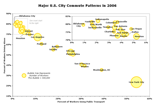
). Portland's rate of public transit use (12.6% of commutes in 2008) is comparable to much larger cities like Los Angeles
Los Ángeles
Los Ángeles is the capital of the province of Biobío, in the commune of the same name, in Region VIII , in the center-south of Chile. It is located between the Laja and Biobío rivers. The population is 123,445 inhabitants...
, and higher than in most similarly sized U.S. cities, but is lower than in some similarly sized cities, such as Baltimore
Baltimore
Baltimore is the largest independent city in the United States and the largest city and cultural center of the US state of Maryland. The city is located in central Maryland along the tidal portion of the Patapsco River, an arm of the Chesapeake Bay. Baltimore is sometimes referred to as Baltimore...
and Seattle.
Much of the downtown Portland
Downtown Portland
Downtown Portland, the city center of Portland, Oregon, United States, is located on the west bank of the Willamette River. It is in the northeastern corner of the southwest section of the city and is where most of the city's high-rise buildings are found....
area (the city center) is in the "Free Rail Zone" (formerly known as Fareless Square), within which rides on light rail and streetcars are fare-free
Zero-fare public transport
Free public transport, also often called free public transit or zero-fare public transport, is a single or network of transport services funded in full by means other than collecting a full fare from passengers. It may be funded by national, regional or local government through taxation or by...
. The fare-free zone covers most of the area between the Willamette River
Willamette River
The Willamette River is a major tributary of the Columbia River, accounting for 12 to 15 percent of the Columbia's flow. The Willamette's main stem is long, lying entirely in northwestern Oregon in the United States...
and Interstate 405
Interstate 405 (Oregon)
Interstate 405 is a short Interstate Highway in Portland, Oregon. It forms a loop from Interstate 5 that travels through downtown Portland west of the Willamette River.-Route description:...
, from Union Station
Union Station (Portland)
Union Station is a train station near the west shore of the Willamette River in the Old Town Chinatown section of Portland, Oregon, United States....
to Portland State University
Portland State University
Portland State University is a public state urban university located in downtown Portland, Oregon, United States. Founded in 1946, it has the largest overall enrollment of any university in the state of Oregon, including undergraduate and graduate students. It is also the only public university in...
, and since 2001 includes a portion of the Lloyd District
Lloyd District, Portland, Oregon
The Lloyd District is a primarily commercial neighborhood in the North and Northeast sections of Portland, Oregon. It is named after Ralph Lloyd , a California rancher, oilman, and real estate developer who moved to and started the development of the area.The Lloyd District is bounded by the...
on the eastside.
Within the Free Rail Zone is the Portland Transit Mall
Portland Transit Mall
The Portland Transit Mall is a set of public transit corridors through the center of downtown Portland, Oregon, United States. More specifically, it is a pair of one-way streets—one for northbound traffic, the other for southbound—along which two of the three lanes are restricted to...
, a transit-priority corridor on which buses and light rail trains from many different parts of the region converge. First opened in 1977, and for three decades served only by buses, the transit mall underwent major changes in 2009. Tracks for light rail (MAX) have been added, bus stops respaced, and the left lane opened to general traffic (but with right turns prohibited). To facilitate this major renovation and rebuilding, lasting more than two years, all bus routes using the mall were diverted to other streets (mainly 3rd and 4th avenues) starting in January 2007. The transit mall reopened to buses on May 24, 2009, and operator training runs on the new light-rail tracks took place during the late spring and summer. Light rail service on the transit mall was introduced on August 30, 2009, when the MAX Yellow Line
MAX Yellow Line
The MAX Yellow Line is a 5.8-mile route in the Metropolitan Area Express light rail system in Portland, Oregon. The route, which opened May 1, 2004, runs between Portland State University , in downtown Portland, and the Portland Expo Center...
moved to the mall from its previous routing. The new MAX Green Line
MAX Green Line
The MAX Green Line is a light rail route in the MAX Light Rail system in Portland, Oregon, United States, extending to Clackamas, Oregon. Construction began in early 2007, and the line opened on September 12, 2009. The average daily ridership in June 2010 was 19,500 increasing to 23,200 by April...
opened 13 days later, on September 12, and it also serves the downtown transit mall.
Buses
TriMet operates a fleet of 651 buses on a network of 81 bus routes. 12 of the routes are designated "Frequent Service" bus routes, with more frequent schedules than other routes. Originally intended to have buses scheduled every 15 minutes or less all day, every day (including weekends and holidays) recent budget cutbacks have forced many of the "Frequent Service" routes to have longer waits, especially on Sundays. TriMet's bus fleet is made up of 30' and 40' buses, with half of the buses older high-floor models built from 1990–1994 and 1998, and the other half are low floor buses manufactured from 1998 to current. TriMet's bus routes also include express buses from downtown Portland to South Beaverton, Sherwood and Oregon City, and express buses from Marquam Hill to Beaverton, Tigard, Southwest Portland, and Milwaukie. TriMet also has several "cross-town" routes that do not serve downtown Portland.The bus network operates predominately in a hub-and-spoke network starting with the downtown Portland transit mall, and includes outlying transit centers in Portland's suburbs.
In addition to the fixed-route service, TriMet operates a paratransit service known as LIFT which operates 254 minibuses and 15 sedans offering door-to-door service for citizens who cannot access regular TriMet services.
MAX light rail
Portland's light railLight rail
Light rail or light rail transit is a form of urban rail public transportation that generally has a lower capacity and lower speed than heavy rail and metro systems, but higher capacity and higher speed than traditional street-running tram systems...
system, named MAX (short for Metropolitan Area Express), consists of four color-coded lines as of September 2009:
- The Blue LineMAX Blue LineThe MAX Blue Line is a 33 mile light rail line in the MAX Light Rail system in the Portland metropolitan area in the U.S. state of Oregon. Operated by TriMet, the line runs between Hillsboro and Gresham, via downtown Portland...
is a 33-mile (53 km) east-west route. It begins in HillsboroHillsboro, OregonHillsboro is the fifth-largest city in the U.S. state of Oregon and is the county seat of Washington County. Lying in the Tualatin Valley on the west side of the Portland metropolitan area, the city is home to many high-technology companies, such as Intel, that compose what has become known as the...
, a western suburb, passes through BeavertonBeaverton, OregonBeaverton is a city in Washington County, Oregon, United States, seven miles west of Portland in the Tualatin River Valley.As of the 2010 census, the population is 90,267. This makes it the second-largest city in the county and Oregon's sixth-largest city...
and downtown PortlandDowntown PortlandDowntown Portland, the city center of Portland, Oregon, United States, is located on the west bank of the Willamette River. It is in the northeastern corner of the southwest section of the city and is where most of the city's high-rise buildings are found....
, then across the Willamette River, through Northeast Portland and east to the city of GreshamGresham, Oregon- Demographics :As of the census of 2000, there were 90,205 people, 33,327 households, and 22,695 families residing in the city. The population density was 4,071.6 people per square mile . There were 35,309 housing units at an average density of 1,593.8 per square mile...
. The 15-mile line between downtown and Gresham was the first light rail line opened in Portland, in 1986. MAX lines first became designated by colors in 2000. - The Red LineMAX Red LineThe MAX Red Line is a route in the Metropolitan Area Express light rail system in the Portland, Oregon metropolitan area. It is 25.5 miles long...
incorporates a 5.6-mile (9 km) north-south addition between the airportPortland International AirportPortland International Airport is a joint civil-military airport and the largest airport in the U.S. state of Oregon, accounting for 90% of passenger travel and more than 95% of air cargo of the state. It is located within Portland's city limits just south of the Columbia River in Multnomah...
and the Gateway Transit CenterGateway/Northeast 99th Avenue Transit Center (MAX station)The Gateway/Northeast 99th Avenue Transit Center station is a light rail station on the MAX Blue, Green and Red lines in Portland, Oregon, United States. It is the 15th stop eastbound on the Eastside MAX, and it is where all three lines split eastbound....
near the northeast Portland neighborhood of ParkroseParkrose, Portland, OregonParkrose is a neighborhood in the Northeast section of Portland, Oregon.The Parkrose plat was filed October 5, 1911. A branch post office of Portland was established there in 1921....
. From that point the line overlaps the Blue Line, running west to downtown and beyond, terminating at the Beaverton Transit Center, where it and the Blue Line meet WES, a commuter rail service. - The Yellow LineMAX Yellow LineThe MAX Yellow Line is a 5.8-mile route in the Metropolitan Area Express light rail system in Portland, Oregon. The route, which opened May 1, 2004, runs between Portland State University , in downtown Portland, and the Portland Expo Center...
added 5.8 miles (9.3 km) to the system. It connects North Portland's Expo CenterPortland Metropolitan Exposition CenterThe Portland Metropolitan Exposition Center, usually referred to as the Expo Center, is a convention center located in the Kenton neighborhood of Portland, Oregon. Opened in the early 1920s as a livestock exhibition and auction facility, the Expo Center now hosts over 100 events a year, including...
with downtown. This line is often referred to as "Interstate MAX" because much of it runs along Interstate Avenue, and parallel to I-5. Until 2009, the Yellow Line followed the same mostly east-west alignment through downtown Portland as used by the Blue and Red lines, traveling along Morrison Street (westbound) and Yamhill Street (eastbound) through the core of the business district. However, on August 30, 2009, the Yellow Line shifted to a new north-south alignment through downtown that has been constructed along the Portland MallPortland Transit MallThe Portland Transit Mall is a set of public transit corridors through the center of downtown Portland, Oregon, United States. More specifically, it is a pair of one-way streets—one for northbound traffic, the other for southbound—along which two of the three lanes are restricted to...
(see Green Line). - The Green LineMAX Green LineThe MAX Green Line is a light rail route in the MAX Light Rail system in Portland, Oregon, United States, extending to Clackamas, Oregon. Construction began in early 2007, and the line opened on September 12, 2009. The average daily ridership in June 2010 was 19,500 increasing to 23,200 by April...
runs from Clackamas Town CenterClackamas Town CenterClackamas Town Center is a shopping mall in Clackamas, Oregon . It opened in 1981. It is managed and co-owned by General Growth Properties and is currently anchored by J.C. Penney, Macy's , Nordstrom, and Sears...
, in the ClackamasClackamas, OregonClackamas was a census-designated place in Clackamas County, Oregon, United States. The population was 5,177 at the 2000 census. It is a suburb of Portland, Oregon.It is the location of Camp Withycombe, a military base...
area, north along I-205Interstate 205 (Oregon-Washington)Interstate 205 is a loop route that serves the Portland—Vancouver metropolitan area in the U.S. states of Oregon and Washington. I-205 is officially named the War Veterans Memorial Freeway, and is also known as the East Portland Freeway...
for 6.5 miles (10.5 km) to the Gateway transit center, where the Blue and Red Lines meet. From Gateway, it joins them and travels westwards to downtown Portland along the 1986-opened tracks extending to the Steel BridgeSteel BridgeThe Steel Bridge is a through truss, double lift bridge across the Willamette River in Portland, Oregon, United States. Its lower deck carries railroad and bicycle/pedestrian traffic, while the upper deck carries road traffic and light rail , making the bridge one of the most multimodal in the world...
. From there—a new junction on the bridge's west deck—the Green Line uses 1.8 miles (2.9 km) of new tracks passing Union StationUnion Station (Portland)Union Station is a train station near the west shore of the Willamette River in the Old Town Chinatown section of Portland, Oregon, United States....
and running mainly along the transit mall for the remainder of its route through downtown, sharing that routing with the Yellow Line and terminating at Portland State UniversityPortland State UniversityPortland State University is a public state urban university located in downtown Portland, Oregon, United States. Founded in 1946, it has the largest overall enrollment of any university in the state of Oregon, including undergraduate and graduate students. It is also the only public university in...
.
The next proposed MAX line is a 7.3 miles (11.7 km) extension south from the Portland Mall to Milwaukie
Milwaukie, Oregon
Milwaukie is a city in Clackamas County, Oregon, United States. A very small portion of the city extends into Multnomah County. The population was 20,291 at the 2010 census. Founded in 1848 on the banks of the Willamette River, the city, known as the Dogwood City of the West, was incorporated in...
. Officially named the "Portland–Milwaukie Light Rail Project", it has not yet been assigned a final route color. TriMet maps suggest it may be the Orange Line
MAX Orange Line
The MAX Orange Line is a planned light rail line for the Metropolitan Area Express light rail system in Portland, Oregon, USA. It is currently under construction. The line is the second part of a two-phase transportation plan known as the South Corridor Project, bringing light rail service to...
, but it is more likely to be opened as an extension of the Yellow Line. It would cross the Willamette River on a new bridge and then turn southwards, passing through Southeast Portland along a combination of existing railroad right-of-way and SE McLoughlin Blvd., to downtown Milwaukie. The terminal station would be at Park Avenue, just south of downtown Milwaukie. At the end of March 2009, the Federal Transit Administration
Federal Transit Administration
The Federal Transit Administration is an agency within the United States Department of Transportation that provides financial and technical assistance to local public transit systems. The FTA is one of ten modal administrations within the DOT...
approved the start of preliminary engineering work for this new line, and TriMet hopes to begin construction in 2011 and open the line in 2015.
Portland Streetcar
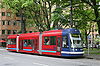
Portland Streetcar
The Portland Streetcar is a streetcar system in Portland, Oregon, that opened in 2001 and serves areas surrounding downtown Portland. It is currently a single line that is almost long and serves some 12,000 daily riders, but a second line is expected to open in 2012.As with the heavier-duty MAX...
runs on a 3.9 miles (6.3 km) route from Legacy Good Samaritan Medical Center at NW 23rd Avenue through inner-Northwest and Southwest, including the Pearl District and Portland State University
Portland State University
Portland State University is a public state urban university located in downtown Portland, Oregon, United States. Founded in 1946, it has the largest overall enrollment of any university in the state of Oregon, including undergraduate and graduate students. It is also the only public university in...
, to the new South Waterfront
South Waterfront
The South Waterfront is a high-rise district under construction on former brownfield industrial land in the South Portland neighborhood south of downtown Portland, Oregon, U.S. It is one of the largest urban redevelopment projects in the United States...
neighborhood, where it connects to the Portland Aerial Tram
Portland Aerial Tram
The Portland Aerial Tram is an aerial tramway in Portland, Oregon, carrying commuters between the city's South Waterfront district and the main Oregon Health & Science University campus, located in the Marquam Hill neighborhood. It is the second commuter aerial tramway in the United States...
. The first portion of this modern-streetcar system opened in 2001.
The last funding needed for a planned $147-million expansion, a 3.3 miles (5.3 km) second route serving the east side, was given tentative approval in April 2009, and construction of this new line began in August 2009. See Portland Streetcar (Future expansion) for more detail.
Area urban planners hope to make use of the right-of-way preserved by the Willamette Shore Trolley
Willamette Shore Trolley
The Willamette Shore Trolley is a heritage railroad or heritage streetcar which operates along the west bank of the Willamette River between Portland and Lake Oswego in Oregon. The right-of-way is owned by group of local-area governments who purchased it in 1988 in order to preserve it intact for...
to more than double the length of the first streetcar line with an extension of about 6 miles (9.7 km) south to Lake Oswego
Lake Oswego, Oregon
Lake Oswego is a city located primarily in Clackamas County in the U.S. state of Oregon. Small portions of the city are also located in neighboring Multnomah and Washington counties. Located south of Portland surrounding the Oswego Lake, the town was founded in 1847 and incorporated as Oswego in...
.
Commuter rail
The 2009-opened Westside Express Service, or simply WES, connects the cities of WilsonvilleWilsonville, Oregon
Wilsonville is a city primarily in Clackamas County, Oregon, United States. A portion of the northern section of the city is in Washington County. Originally founded as Boones Landing due to the Boones Ferry which crossed the Willamette River at the location, the community became Wilsonville in...
, Tualatin
Tualatin, Oregon
Tualatin is a city located primarily in Washington County in the U.S. state of Oregon. A small portion of the city is also located in neighboring Clackamas County. It is a southwestern suburb in the Portland Metropolitan Area that is located south of Tigard...
, Tigard
Tigard, Oregon
Tigard is a city in Washington County, Oregon, United States. The population was 48,035 at the 2010 census. As of 2007, Tigard was the state's 12th largest city. Incorporated in 1961, the city is located south of Beaverton and north of Tualatin, and is part of the Portland metropolitan area...
and Beaverton
Beaverton, Oregon
Beaverton is a city in Washington County, Oregon, United States, seven miles west of Portland in the Tualatin River Valley.As of the 2010 census, the population is 90,267. This makes it the second-largest city in the county and Oregon's sixth-largest city...
. It is one of only three suburb-to-suburb commuter rail lines in the country, along with Tri-Rail
Tri-Rail
Tri-Rail is a commuter rail line linking Miami, Fort Lauderdale, and West Palm Beach, Florida, United States. It is run by the South Florida Regional Transportation Authority. The system has 18 stations along the South Florida coast...
in Miami and the Inland Empire-Orange County Line operated by Metrolink
Metrolink
Metrolink, MetroLink, or Metro-link is the name of several transport services throughout the world:Australia*Metro-link Bus Lines, a bus operator in Sydney, New South Wales...
between San Bernardino and Oceanside, Calif. Rather than electric railcars like those of MAX, the line uses FRA
Federal Railroad Administration
The Federal Railroad Administration is an agency in the United States Department of Transportation. The agency was created by the Department of Transportation Act of 1966...
-compliant diesel multiple unit
Diesel multiple unit
A diesel multiple unit or DMU is a multiple unit train consisting of multiple carriages powered by one or more on-board diesel engines. They may also be referred to as a railcar or railmotor, depending on country.-Design:...
s running on existing Portland and Western Railroad
Portland and Western Railroad
The Portland and Western Railroad is a Class II railroad serving the U.S. state of Oregon, and is a wholly owned subsidiary of shortline and regional railroad holding company Genesee & Wyoming Inc...
freight tracks. The first rides open to the general public took place on Friday, January 30, 2009, and regular service began on Monday, February 2, 2009.
Portland Aerial Tram
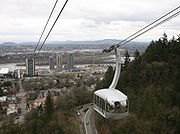
The Portland Aerial Tram
Portland Aerial Tram
The Portland Aerial Tram is an aerial tramway in Portland, Oregon, carrying commuters between the city's South Waterfront district and the main Oregon Health & Science University campus, located in the Marquam Hill neighborhood. It is the second commuter aerial tramway in the United States...
, is an aerial cableway
Aerial tramway
An aerial tramway , cable car , ropeway or aerial tram is a type of aerial lift which uses one or two stationary ropes for support while a third moving rope provides propulsion...
used to connect the South Waterfront
South Waterfront
The South Waterfront is a high-rise district under construction on former brownfield industrial land in the South Portland neighborhood south of downtown Portland, Oregon, U.S. It is one of the largest urban redevelopment projects in the United States...
district with Oregon Health and Science University on Marquam Hill above. The cableway is two-thirds of one mile (1 km) long and was opened to the public in January 2007.
Cycling
Bicycle use in Portland has been growing rapidly, having nearly tripled since 2001; for example, bicycle traffic on four of the Willamette River bridges has increased from 2,855 before 1992 to over 16,000 in 2008, partly due to improved facilities. Approximately 8% of commuters bike to workBicycle commuting
Bicycle commuting is the use of a bicycle to travel from home to a place of work or study — in contrast to the use of a bicycle for sport, recreation or touring....
in Portland, the highest proportion of any major U.S. city and about 10 times the national average.
Walking
According to a city video, in 1994 Portland became the first city to develop a pedestrian master plan. Blocks in the downtown area are only 200 feet (61 m) long. Many streets in the outer southwest section of the city lack sidewalks; however, this is partially made up with various off-street trails.The Gibbs Street Pedestrian Bridge
Gibbs Street Pedestrian Bridge
The Gibbs Street Pedestrian Bridge is a approximately pedestrian bridge under construction in Portland, Oregon, United States. It will connect the Lair Hill neighborhood with the South Waterfront area...
, a planned new pedestrian bridge over I-5 near the Portland Aerial Tram
Portland Aerial Tram
The Portland Aerial Tram is an aerial tramway in Portland, Oregon, carrying commuters between the city's South Waterfront district and the main Oregon Health & Science University campus, located in the Marquam Hill neighborhood. It is the second commuter aerial tramway in the United States...
, is under construction.
Traffic flow
Many roads in Portland are one-way; roads in downtown Portland (Southwest Portland bounded by the 405) are virtually all one-way, forming an alternating grid: for north-south roads, odd avenues (1st, 3rd, etc.) are south-bound, while even avenues (2nd, 4th, etc.) are north-bound, and similarly east-west street alternate; this is partly due to the roads downtown Portland being relatively narrow (64 ft, 20 m). This grid extends a short way west across I-405 into Goose HollowGoose Hollow, Portland, Oregon
Goose Hollow is a neighborhood in southwest Portland, Oregon. It acquired its distinctive name through early residents’ practice of letting their geese run free near the wooded ravine in the Tualatin Mountains now known as the Tanner Creek Canyon and in the now infilled Tanner Creek Gulch...
, terminating at SW 18th Street/PGE Park, and extends to some degree north across Burnside into the Pearl District, particularly with the north/south street extending into Old Town.
Most roads on the east side are two-way, but there are a number of one-way pair
One-way pair
A one-way pair, one-way couple, or just couplet is a pair of parallel, usually one-way streets that carry opposite directions of a signed route or major traffic flow, or sometimes opposite directions of a bus or streetcar route....
s along major routes – major north-south pairs are Martin Luther King Jr. Blvd (MLK)/Grand Ave (4th and 5th Ave), and 11th Ave/12th Ave. East-west pairs are connected with bridges, with NE Couch St/Burnside St forming a pair east of the Burnside bridge from 3rd Ave to 14th Ave, SE Morrison St/SE Belmont St forming a pair from the Morrison bridge to SE 25th Ave, and SE Madison St/SE Hawthorne St forming a pair from the Hawthorne bridge to SE 12th Ave.
Highways
State highwayState highway
State highway, state road or state route can refer to one of three related concepts, two of them related to a state or provincial government in a country that is divided into states or provinces :#A...
s, numbered as Interstate, U.S and Oregon Routes, in the metropolitan area include:
- Interstate 5
- Interstate 84
- Interstate 205
- Interstate 405Interstate 405 (Oregon)Interstate 405 is a short Interstate Highway in Portland, Oregon. It forms a loop from Interstate 5 that travels through downtown Portland west of the Willamette River.-Route description:...
- U.S. Route 26
- U.S. Route 30 (with a business route and a bypass route in addition to the main highway)
- Oregon Route 8
- Oregon Route 10
- Oregon Route 43
- Oregon Route 99E
- Oregon Route 99W
- Oregon Route 210
- Oregon Route 212
- Oregon Route 213
- Oregon Route 217
- Oregon Route 219
- Oregon Route 224
Portland is also well known for the highways that it didn't build, or removed altogether, such as the Mount Hood Freeway, Interstate 505, and Harbor Drive
Harbor Drive
Harbor Drive is the name of a street in Portland, Oregon, which was formerly a freeway that carried U.S. Route 99W along the western shore of the Willamette River in the downtown area...
.
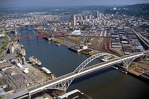
Bridges
The large number of bridges in Portland has given the city its "Bridgetown" nickname.Willamette River
Bridges over the Willamette RiverWillamette River
The Willamette River is a major tributary of the Columbia River, accounting for 12 to 15 percent of the Columbia's flow. The Willamette's main stem is long, lying entirely in northwestern Oregon in the United States...
, listed north to south:
- St. Johns BridgeSt. Johns BridgeThe St. Johns Bridge is a steel suspension bridge that spans the Willamette River in Portland, Oregon, USA, between the St. Johns neighborhood and the northwest industrial area around Linnton. It is the only suspension bridge in the Willamette Valley and one of three public highway suspension...
(1931) - U.S. Route 30/N Philadelphia Avenue - Burlington Northern Railroad Bridge 5.1Burlington Northern Railroad Bridge 5.1The Burlington Northern Railroad Bridge 5.1 or BNSF Railway Bridge 5.1, also known as the St. Johns Railroad Bridge or the Willamette River Railroad Bridge, is a through truss railway bridge with a vertical lift that spans the Willamette River in Portland, Oregon, United States...
(1908) - Fremont Bridge (1973) - Interstate 405Interstate 405 (Oregon)Interstate 405 is a short Interstate Highway in Portland, Oregon. It forms a loop from Interstate 5 that travels through downtown Portland west of the Willamette River.-Route description:...
- BroadwayBroadway Bridge (Portland)The Broadway Bridge is a bascule bridge that spans the Willamette River in Portland, Oregon, U.S. It was the first bascule bridge built in Portland and the longest in the world at the time of its completion. It is the longest Rall-type bascule bridge still in existence.-History and description:The...
(1913) - Broadway - Steel BridgeSteel BridgeThe Steel Bridge is a through truss, double lift bridge across the Willamette River in Portland, Oregon, United States. Its lower deck carries railroad and bicycle/pedestrian traffic, while the upper deck carries road traffic and light rail , making the bridge one of the most multimodal in the world...
(1912) - Pacific Highway West/former Oregon Route 99W - Burnside BridgeBurnside BridgeThe Burnside Bridge is a bascule bridge that spans the Willamette River in Portland, Oregon.-Design:Including approaches, the Burnside has a total length of and a center span. While lowered this span is normally above the river. The deck is made of concrete, which contributes to its being one of...
(1926) - Burnside Street - Morrison BridgeMorrison BridgeThe Morrison Bridge is a bascule bridge that spans the Willamette River in Portland, Oregon.The original Morrison Bridge was a wooden truss swing span bridge completed on April 12, 1887 as the first Willamette River bridge in Portland and the longest bridge west of the Mississippi River...
(1958) - Morrison Street - Hawthorne BridgeHawthorne BridgeThe Hawthorne Bridge is a truss bridge with a vertical lift that spans the Willamette River in Portland, Oregon, joining Hawthorne Boulevard and Madison Street. It is the oldest vertical-lift bridge in operation in the United States and the oldest highway bridge in Portland...
(1910) - Hawthorne Boulevard - Marquam Bridge (1966) - Interstate 5
- Ross Island BridgeRoss Island BridgeThe Ross Island Bridge is a cantilever truss bridge that spans the Willamette River in Portland, Oregon. It carries U.S. Route 26 across the river between southwest and southeast Portland...
(1922) - U.S. Route 26/Powell Boulevard - Sellwood BridgeSellwood BridgeThe Sellwood Bridge is a truss bridge that spans the Willamette River in Portland, Oregon, in the United States. It was Portland's first fixed-span bridge and, being the only river crossing for miles in each direction, is the busiest two-lane bridge in Oregon...
(1925) - SE Tacoma Street
Caruthers Bridge
Caruthers Bridge
The Caruthers Bridge is the working name for a bridge currently under construction across the Willamette River in Portland, Oregon, United States. The bridge will carry MAX light rail, the Portland Streetcar, buses, bicycles, and pedestrians. Private cars and trucks will not be permitted on the...
is the working name for a planned new bridge across the Willamette.
Columbia River
Bridges over the Columbia River, listed west to east:- Burlington Northern Railroad Bridge 9.6Burlington Northern Railroad Bridge 9.6Burlington Northern Railroad Bridge 9.6 or BNSF Railway Bridge 9.6, also known as the Columbia River Railroad Bridge, is through truss railway bridge across the Columbia River, between Portland, Oregon, and Vancouver, Washington, owned and operated by BNSF Railway...
(1908) - Interstate BridgeInterstate BridgeThe Interstate Bridge is a pair of nearly identical steel vertical-lift, through-truss bridges that carry Interstate 5 traffic over the Columbia River between Vancouver, Washington, and Portland, Oregon, in the United States...
(1917/1958) - Interstate 5 - Glenn L. Jackson Memorial BridgeGlenn L. Jackson Memorial BridgeThe Glenn L. Jackson Memorial Bridge, or I-205 bridge, is a segmental bridge that spans the Columbia River between Vancouver, Washington and Portland, Oregon....
(1982) - Interstate 205Interstate 205 (Oregon-Washington)Interstate 205 is a loop route that serves the Portland—Vancouver metropolitan area in the U.S. states of Oregon and Washington. I-205 is officially named the War Veterans Memorial Freeway, and is also known as the East Portland Freeway...
Rail service (intercity)
Long-distance passenger rail service to Portland is provided by AmtrakAmtrak
The National Railroad Passenger Corporation, doing business as Amtrak , is a government-owned corporation that was organized on May 1, 1971, to provide intercity passenger train service in the United States. "Amtrak" is a portmanteau of the words "America" and "track". It is headquartered at Union...
, the national passenger rail system, with trains stopping at Union Station
Union Station (Portland)
Union Station is a train station near the west shore of the Willamette River in the Old Town Chinatown section of Portland, Oregon, United States....
. Amtrak routes serving Portland include the Coast Starlight
Coast Starlight
The Coast Starlight is a passenger train operated by Amtrak on the West Coast of the United States. It runs from King Street Station in Seattle, Washington, to Union Station in Los Angeles, California. The train's name was formed as a merging of two of Southern Pacific's train names, the Coast...
(with service from Los Angeles to Seattle) and the Empire Builder
Empire Builder
The Empire Builder is a passenger train route operated by Amtrak in the Midwestern and Northwestern United States. It is Amtrak's busiest long-distance route and busiest daily train, carrying more than 500,000 travelers annually since 2007. Overall, it is the railroad's 10th-busiest line. Before...
(with service from Portland to Chicago), along with the Amtrak Cascades
Amtrak Cascades
The Amtrak Cascades is a passenger train route operated by Amtrak in partnership with the states of Washington and Oregon in the Pacific Northwest of the United States and the province of British Columbia in Canada...
trains, operating between Vancouver, British Columbia
Vancouver
Vancouver is a coastal seaport city on the mainland of British Columbia, Canada. It is the hub of Greater Vancouver, which, with over 2.3 million residents, is the third most populous metropolitan area in the country,...
and Eugene, Oregon
Eugene, Oregon
Eugene is the second largest city in the U.S. state of Oregon and the seat of Lane County. It is located at the south end of the Willamette Valley, at the confluence of the McKenzie and Willamette rivers, about east of the Oregon Coast.As of the 2010 U.S...
.
Airports
Portland's main airport is the Portland International AirportPortland International Airport
Portland International Airport is a joint civil-military airport and the largest airport in the U.S. state of Oregon, accounting for 90% of passenger travel and more than 95% of air cargo of the state. It is located within Portland's city limits just south of the Columbia River in Multnomah...
, located in the northeast quadrant, near the Columbia River
Columbia River
The Columbia River is the largest river in the Pacific Northwest region of North America. The river rises in the Rocky Mountains of British Columbia, Canada, flows northwest and then south into the U.S. state of Washington, then turns west to form most of the border between Washington and the state...
, and 20 minutes by car from Downtown. PDX is also connected to the downtown business and arts districts by the MAX Red Line.
The Port of Portland's Hillsboro Airport
Hillsboro Airport
Hillsboro Airport , also known as Portland-Hillsboro Airport, is the name of a corporate, general aviation and flight-training airport serving the city of Hillsboro, in Washington County, Oregon, USA. It is one of four airports in the Portland, Oregon, metropolitan area owned and operated by the...
is an executive and general aviation
General aviation
General aviation is one of the two categories of civil aviation. It refers to all flights other than military and scheduled airline and regular cargo flights, both private and commercial. General aviation flights range from gliders and powered parachutes to large, non-scheduled cargo jet flights...
airport located in Hillsboro, Oregon
Hillsboro, Oregon
Hillsboro is the fifth-largest city in the U.S. state of Oregon and is the county seat of Washington County. Lying in the Tualatin Valley on the west side of the Portland metropolitan area, the city is home to many high-technology companies, such as Intel, that compose what has become known as the...
, and it the second busiest airport in the state. It is connected to the metropolitan area by MAX Blue Line, and is the starting point for many corporate and charter flights, including Nike, Inc.
Nike, Inc.
Nike, Inc. is a major publicly traded sportswear and equipment supplier based in the United States. The company is headquartered near Beaverton, Oregon, which is part of the Portland metropolitan area...
and the Portland Trail Blazers
Portland Trail Blazers
The Portland Trail Blazers, commonly known as the Blazers, are an American professional basketball team based in Portland, Oregon. They play in the Northwest Division of the Western Conference in the National Basketball Association . The Trail Blazers originally played their home games in the...
NBA team. Hillsboro is currently being considered for commercial traffic to relieve the increasingly congested PDX.
Troutdale Airport
Troutdale Airport
Portland-Troutdale Airport is a public use airport located 10 nautical miles east of the central business district of Portland, in Multnomah County, Oregon, United States. Also known as Troutdale Airport, it is located in Troutdale...
also serves the area. Portland is also served by Wiley's Seaplane Port
Wiley's Seaplane Port
Wiley's Seaplane Port is a seaplane base on the Willamette River in Lake Oswego, Oregon, within the Portland metropolitan area. It was activated in March 1979, and run by Dave Wiley for nearly 30 years....
, a private seaplane
Seaplane
A seaplane is a fixed-wing aircraft capable of taking off and landing on water. Seaplanes that can also take off and land on airfields are a subclass called amphibian aircraft...
base on the Willamette.
Portland is home to Oregon's only public use heliport, the Portland Downtown Heliport
Portland Downtown Heliport
Portland Downtown Heliport , is a public heliport located in the Old Town Chinatown neighborhood in the Northwest section of the city of Portland, Multnomah County, Oregon, USA...
.
Other alternatives
Portlanders living downtown or in nearby neighborhoods have car sharing as an alternative, through ZipcarZipcar
Zipcar is an American membership-based car sharing company providing automobile reservations to its members, billable by the hour or day. Zipcar was founded in 2000 by Cambridge, Massachusetts residents Antje Danielson and Robin Chase, and is now led by Scott Griffith, Chairman and Chief Executive...
, which acquired Flexcar
Flexcar
-External links:***...
in 2007. , there are over 5,000 members sharing 70 vehicles which are located in neighborhoods such as the Pearl District, Old Town Chinatown
Old Town Chinatown, Portland, Oregon
Old Town Chinatown is a neighborhood in the Northwest section of Portland, Oregon. The Willamette River forms its eastern boundary, separating it from the Lloyd District and the Kerns and Buckman neighborhoods...
, the Lloyd District
Lloyd District, Portland, Oregon
The Lloyd District is a primarily commercial neighborhood in the North and Northeast sections of Portland, Oregon. It is named after Ralph Lloyd , a California rancher, oilman, and real estate developer who moved to and started the development of the area.The Lloyd District is bounded by the...
, Hawthorne
Hawthorne, Portland, Oregon
The Hawthorne District in Portland, Oregon is an area of Southeast Portland on SE Hawthorne Blvd., particularly between 30th and 42nd Avenues. The area has numerous retail stores, including clothing shops, restaurants, bars, brewpubs and microbreweries. Hawthorne district is known for its young,...
, and Brooklyn
Brooklyn, Portland, Oregon
Brooklyn is a mostly residential neighborhood in southeast Portland, Oregon. It sits along the east side of the Willamette River in the vicinity of Reed College...
.
Skateboarding
Skateboarding
Skateboarding is an action sport which involves riding and performing tricks using a skateboard.Skateboarding can be a recreational activity, an art form, a job, or a method of transportation. Skateboarding has been shaped and influenced by many skateboarders throughout the years. A 2002 report...
and roller blading are welcome methods for travel around town. Downtown
Portland includes signs labeled "skate routes" to aid the urban skater. The Wall Street Journal
The Wall Street Journal
The Wall Street Journal is an American English-language international daily newspaper. It is published in New York City by Dow Jones & Company, a division of News Corporation, along with the Asian and European editions of the Journal....
stated Portland "may be the most skateboard-friendly town in America."
See also
- Transportation in SeattleTransportation in SeattleAs with almost every other city in western North America, transportation in Seattle is dominated by automobiles, although Seattle is just old enough that the city's layout reflects the age when railways and streetcars dominated...
and Transportation in VancouverTransportation in VancouverTransportation in Vancouver has many of the features of modern cities worldwide and some interesting differences. Unlike many large metropolises, Vancouver has no freeways into or through the downtown area. A proposed freeway through the downtown was rejected in the 1960s by a coalition of...
for Pacific NorthwestPacific NorthwestThe Pacific Northwest is a region in northwestern North America, bounded by the Pacific Ocean to the west and, loosely, by the Rocky Mountains on the east. Definitions of the region vary and there is no commonly agreed upon boundary, even among Pacific Northwesterners. A common concept of the...
comparisons - Neil GoldschmidtNeil GoldschmidtNeil Edward Goldschmidt is an American businessman and former Democratic politician from Oregon who held local, state, and federal offices over three decades. After serving as the governor of Oregon, Goldschmidt is widely considered the most influential figure in the state's politics, both as an...
, a Portland Mayor and U.S. Secretary of Transportation who exerted broad influence on transportation in Portland - Rose City TransitRose City TransitThe Rose City Transit Company was a private company that operated most mass transit service in the city of Portland, Oregon, from 1956 to 1969. It operated only within the city proper...
, predecessor of TriMet within Portland
External links
- City of Portland's Office of Transportation
- Oregon Department of TransportationOregon Department of TransportationThe Oregon Department of Transportation is a department of the state government of the U.S. state of Oregon responsible for systems of transportation. It was first established in 1969. It had been preceded by the Oregon State Highway Department which, along with the Oregon State Highway...
's TripCheck, including a speed-of-traffic map (in GIFGIFThe Graphics Interchange Format is a bitmap image format that was introduced by CompuServe in 1987 and has since come into widespread usage on the World Wide Web due to its wide support and portability....
format) - ODOT's Portland-area projects
- TriMet
- Portland's Bicycle Transportation Alliance
- Portland SHIFT to Bikes
- Multnomah County bridges