

Transportation in Seattle
Encyclopedia
As with almost every other city in western North America
, transportation in Seattle
is dominated by automobiles, although Seattle is just old enough that the city's layout reflects the age when railways and streetcars (known locally as "trolleys") dominated. These older modes of transportation made for a relatively well-defined downtown and strong neighborhoods at the end of several former streetcar lines, most of them now bus lines.
Because of the isthmus
-like geography of Seattle and the concentration of jobs within the city, much of the transportation movement in the Seattle metropolitan area
is through the city proper. North-south transportation is highly dependent on Interstate 5 corridor, which connects the Puget Sound area with southwest Washington cities, the Portland metropolitan area
, and cities to the north such as Bellingham
. I-5 continues as British Columbia Highway 99 at the US-Canada
border's Peace Arch
crossing, between Blaine
and Surrey
. State Route 99
is also a major arterial in the western half of the city and includes the Alaskan Way Viaduct
along the Seattle waterfront. Because of seismic instability, there are plans to replace the viaduct
.
Transportation to and from the east is via State Route 520's Evergreen Point Floating Bridge
and Interstate 90's Lacey V. Murrow Memorial Bridge
and Third Lake Washington Bridge, all over Lake Washington
. Those bridges are the first, second, and fifth longest floating bridge
s in the world, respectively. State Route 522 connects Seattle to its northeastern suburbs.
Unlike most North American cities, water transportation remains important. Washington State Ferries
, the largest ferry system in the United States and the third largest in the world, operates a passenger-only ferry from Colman Dock
in Downtown to Vashon Island
, car ferries from Colman Dock to Bainbridge Island and to Bremerton, and a car ferry from West Seattle
to Vashon Island to Southworth
. Seattle was once home to the Kalakala
, a streamlined art deco
-style ferry that plied the waters from the 1930s to the 1960s. The ship has since fallen into disrepair.
Seattle contains most of Boeing Field
, officially called King County International Airport, but most of the city's airline passengers use Seattle-Tacoma International Airport
in the city of SeaTac
. Seattle is also served by three Amtrak
routes at King Street Station: the Cascades, the Coast Starlight
, and the Empire Builder
.
routes. Seattle is also serviced by an extensive network of bus routes and two commuter rail routes connecting it to many of its suburbs.
Organized land transportation in Seattle dates back at least to 1871; by that date a wagon traveled twice daily from what is now First Avenue (near Elliott Bay) to Lake Washington; the fare was 50 cents, no small sum for that era. In 1880 a two-horse carriage carried passengers and freight from roughly today's Pioneer Square
to Belltown
every two hours at a fare of 12.5 cents in an open coach or 15 cents in a covered coach. This was shortly followed by similar services connecting out to Lake Union
and to Madison Park
on Lake Washington.
Water transport was important in this era even within what are now city limits. A steamer connected South Lake Union
to Latona (between today's Lower Wallingford
and the University District
and another steamer crossed Green Lake
.
The first street railway came in 1884, with horse-drawn cars
plying 3.5 miles (5.6 km) of track up today's Second Avenue to Pine Street, then up First Avenue to Battery Street. Yesler Way and Jackson Street got their cable car
s (from Pioneer Square to Lake Washington) in 1888, allowing public transportation on routes over hills too steep for horses. Electric streetcars appeared in 1889, making Seattle one of the first cities in the United States to adopt this innovation.
The Great Seattle Fire
did not slow this progress at all: by 1890, there were lines along the waterfront from South Seattle (today's South Park
) to Lower Queen Anne
and from the center of town to Capitol Hill
, Madison Park, and Madrona
. These were instrumental in the creation of a relatively well-defined downtown and strong neighborhoods at the end of their lines.
At the turn of the century, the streets were so bad that a boy named Joseph Bufonchio drowned in a sink-hole at the corner of Third and Jackson. As Gordon Newell noted in 1956, contemporary reports did not seem to consider this particularly unusual.
At that time, there were about 25 independent transit lines in Seattle. By 1907, the Seattle Electric Company, owned by Boston
-based Stone and Webster, leveraged its foothold in the electric power industry to consolidate these into one operation, known after 1912 as the Puget Sound Traction, Light and Power Company. It cost a nickel (5 cents) to ride. Puget Sound Traction was bought out by the city in 1919 for US$15 million. However, under the city's management the streetcars chronically ran a loss (even after a 1923 fare increase to three rides for a quarter, a fare of 8-and-a-third cents), and the quality of the system deteriorated.
The advent of the automobile sounded the death knell for rail in Seattle. Tacoma–Seattle railway service ended in 1929 and the Everett–Seattle service came to an end in 1939, replaced by inexpensive automobiles running on the recently developed highway system. When the city received a US$10.2 million federal grant to pay off transit-related debts and modernize its transit system, rails on city streets were paved over or removed, and the opening in 1940 of the Seattle trolleybus system
brought the end of streetcar service in Seattle in the early hours of April 12, 1941. This left an extensive network of buses (including 188 miles (302.6 km) of trolleybus
lines) under an independent Municipal Transportation Commission as the only mass transit within the city and throughout the region.
The new transit system was jammed and profitable during the gasoline and rubber rationing
of World War II
, but the automobile reigned supreme after the war. Fares rose to 10 cents, the first of many increases that would lead to a present-day fare of $2.25-$3.00.
in the 1880s, in the days of horse-drawn vehicles. At that time, traffic in the Pioneer Square
neighborhood was limited to 6 miles per hour (9.7 km/h).
The city is described in a mid-20th-century Civics
textbook as "a city of islands—islands created both by water and by abrupt valleys that can be traversed only by bridges." Already by 1948, 221,500 vehicles a day crossed the city's bridges across the Lake Washington Ship Canal
and Duwamish River
; except for the high Aurora Bridge (officially George Washington Memorial Bridge
) across the Ship Canal, these were all drawbridge
s. This was before the construction of the Interstate Highways or State Route 520; the original Lake Washington Floating Bridge
(opened 1940) provided the only road out of town to the east; construction of the Alaskan Way Viaduct, the first limited access highway through the city center, was still under way.
Even with the lesser population of that time and fewer major highways, difficulty parking downtown had already become "practically an institution". The total number of vehicles parking downtown in a day would already have filled a parking lot the size of downtown had they all been there at once; naturally, many of these were there only briefly for shopping. Parking meters had been introduced in the early 1940s, and multi-level parking garages provided some relief (and would later provide more), but the impact of the automobile on the city was very apparent. The city was considering various proposals, such as the establishment of large parking lots on the periphery of downtown with shuttle buses into the center. The city was seeking (and failing to get) state permission to use the right of eminent domain
to acquire property for multi-level parking lots. Later, in the mid-1960s, the historic Seattle Hotel
building was torn down for just this purpose; the reaction against that sparked the preservationist movement for the revival of Pioneer Square, and made it clear that the city would not solve its problem by demolishing a ring around downtown.
that runs along the Elliott Bay waterfront in Seattle's Industrial District and downtown Seattle. It is the smaller of the two major north-south traffic corridors through Seattle, carrying up to 110,000 vehicles per day. The viaduct runs above the surface street, Alaskan Way, from S. Nevada Street in the south to the entrance of Belltown's
Battery Street Tunnel in the north, following previously existing railroad
lines.
The 2001 Nisqually earthquake
damaged the viaduct and its supporting Alaskan Way Seawall
and required the Washington State Department of Transportation
(WSDOT) to invest $3.5 million U.S. in emergency repairs. Experts give a 1-in-20 chance that the viaduct could be shut down by an earthquake within the next decade. Since the Nisqually Earthquake occurred, semi-annual inspections have discovered continuing settlement damage.
Whether to remove, replace, or rebuild the viaduct is a politically charged issue. On March 13, 2007, voters in the city of Seattle rejected two separate proposals to replace the viaduct.
. Snohomish County's Community Transit also runs bus routes to Downtown Seattle and the University of Washington. Sound Transit is the regional transit authority, commissioned by voters in 1996 to build a system of light rail
, express buses, and commuter rail within the Central Puget Sound area
. The agency provides a number of regional express bus routes connecting Seattle with neighboring suburbs and cities. Its Sounder
commuter rail system consists of two lines, linking Seattle with Tacoma
along its Southern run and Seattle with Everett
along its Northern run. Several stations in intermediate cities along the lines are also served. The light rail
system, called Link Light Rail
, includes the initial 15.7 miles (25.3 km) Central Link
from downtown Seattle to Sea-Tac Airport, which began in 2009. A 3.15 miles (5.07 km) mile extension of the line called University Link
was approved for final design in November 2006, with construction expected to begin in 2009 and finish in 2016 at a cost of $1.5 billion. Future extensions that were approved by voters in 2008 are planned to connect the University of Washington
to Northgate
, Lynnwood
and other areas to the north; east across Lake Washington
to Bellevue
and Redmond
; and south to Federal Way
.
The Downtown Seattle Transit Tunnel
is a 1.3-mile tunnel under downtown built in 1987 to relieve bus congestion along surface streets. In 2009, Link light rail trains began serving tunnel stations as part of the initial Central Link segment. The tunnel was retrofitted from 2005-2007 to accommodate light rail. All tunnel bus routes will be rerouted in 2016, making the tunnel an exclusive subway for Link trains within the city core.
The city is currently in the process of expanding a modern streetcar network. In December 2007, the city inaugurated its South Lake Union Streetcar
line between Westlake Center
and stops in the South Lake Union
neighborhood. In 2009, the Seattle city council also approved a second line to run between the Capitol Hill, First Hill, and Chinatown-International District neighborhoods. The First Hill Streetcar
will connect to Link light rail stations and is expected to begin service as early as 2013. Metro Transit also operated a historic Waterfront Streetcar
line that ran along Alaskan Way
, but the streetcar's maintenance barn was demolished to make room for the Olympic Sculpture Park
, resulting in the subsequent closure of the line. King County Metro now operates a replacement bus line that mirrors the route.
In 2009, the ORCA Card
was introduced as a new way for fare payment between the seven transit agencies in the Puget Sound region. The card uses RFID technology to handle payment from either passes, vouchers, or the E-purse, a stored value debit account. ORCA's precursor, PugetPass, will be retained as one of the several passes that can be loaded automatically onto the card. The system also calculates transfers for a two-hour window for those paying with the E-purse.
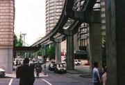 The Seattle Center Monorail
, constructed for the Century 21 Exposition
, connects Downtown and Seattle Center
.
Metro Transit offers a trip planner on its web site that provides information for public transit in Seattle and surrounding areas (King, Pierce, and Snohomish counties), including Sound Transit
's Regional Express bus routes, Sounder commuter rail, Washington State Ferries, and the Seattle Center Monorail
. Riders enter their intended origin and destination, along with optional time, date, and other information, and the trip planner displays itineraries showing the stops, departure and arrival times, and times to get from the origin to the destination. Metro Transit uploads their route schedules to Google and this has spawned a new generation of trip planners such as TransitTrips.
Over 15,000 Seattleites are members of the car sharing program Zipcar
(formerly Flexcar
). While not all members are frequent users, the use of these shared cars has been substantial enough to justify the purchase of over 150 cars and other light vehicles for the program, with an additional vehicle purchased approximately every ten days.
In addition, there are extensive multi-use car-free regional pathways linking the city and county to the surrounding areas. For example, one could ride a bicycle from Ballard
via the Burke-Gilman Trail
, to Redmond
via the Sammamish River Trail
, then to Issaquah
via Snohomish River/East Lake Sammamish Trail
, a distance of roughly 40 miles.
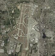 The city's primary commercial airport is Seattle-Tacoma International Airport
, locally known as Sea–Tac Airport and located in the city of SeaTac
, which is named for the airport. It is operated by the Port of Seattle
and is served by a number of airlines connecting the region with international, national, and domestic destinations. The airport is a major hub for Alaska Airlines
and its regional subsidiary Horizon Air
.
Closer to downtown, Boeing Field
is used for general aviation, cargo flights, and testing/delivery of Boeing airliners. In 2005, Southwest Airlines
and Alaska Airlines requested permission to move passenger operations from Sea–Tac to Boeing Field but were turned down by the county.
North America
North America is a continent wholly within the Northern Hemisphere and almost wholly within the Western Hemisphere. It is also considered a northern subcontinent of the Americas...
, transportation in Seattle
Seattle, Washington
Seattle is the county seat of King County, Washington. With 608,660 residents as of the 2010 Census, Seattle is the largest city in the Northwestern United States. The Seattle metropolitan area of about 3.4 million inhabitants is the 15th largest metropolitan area in the country...
is dominated by automobiles, although Seattle is just old enough that the city's layout reflects the age when railways and streetcars (known locally as "trolleys") dominated. These older modes of transportation made for a relatively well-defined downtown and strong neighborhoods at the end of several former streetcar lines, most of them now bus lines.
Because of the isthmus
Isthmus
An isthmus is a narrow strip of land connecting two larger land areas usually with waterforms on either side.Canals are often built through isthmuses where they may be particularly advantageous to create a shortcut for marine transportation...
-like geography of Seattle and the concentration of jobs within the city, much of the transportation movement in the Seattle metropolitan area
Seattle metropolitan area
The Seattle metropolitan area in the US state of Washington includes the city of Seattle, King County, Snohomish County, and Pierce County within the Puget Sound region. The U.S...
is through the city proper. North-south transportation is highly dependent on Interstate 5 corridor, which connects the Puget Sound area with southwest Washington cities, the Portland metropolitan area
Portland metropolitan area
The Portland-Vancouver-Hillsboro, OR-WA Metropolitan Statistical Area , also known as the Portland metropolitan area or Greater Portland, is an urban area in the U.S. states of Oregon and Washington centered around the city of Portland, Oregon. The U.S...
, and cities to the north such as Bellingham
Bellingham, Washington
Bellingham is the largest city in, and the county seat of, Whatcom County in the U.S. state of Washington. It is the twelfth-largest city in the state. Situated on Bellingham Bay, Bellingham is protected by Lummi Island, Portage Island, and the Lummi Peninsula, and opens onto the Strait of Georgia...
. I-5 continues as British Columbia Highway 99 at the US-Canada
Canada
Canada is a North American country consisting of ten provinces and three territories. Located in the northern part of the continent, it extends from the Atlantic Ocean in the east to the Pacific Ocean in the west, and northward into the Arctic Ocean...
border's Peace Arch
Peace Arch
The Peace Arch is a monument situated on the Canada – United States border between the communities of Blaine, Washington and Surrey, British Columbia. The Peace Arch, which stands...
crossing, between Blaine
Blaine, Washington
Blaine is a city in Whatcom County, Washington, United States. The city's northern boundary is the Canadian border. Blaine is the shared home of the Peace Arch international monument...
and Surrey
Surrey, British Columbia
Surrey is a city in the province of British Columbia, Canada. It is a member municipality of Metro Vancouver, the governing body of the Greater Vancouver Regional District...
. State Route 99
State Route 99 (Washington)
State Route 99, abbreviated SR 99, commonly called Highway 99, is a numbered state highway in the U.S. state of Washington extending just under from Fife in the south to Everett in the north, with a gap in Tukwila.-Southern division:...
is also a major arterial in the western half of the city and includes the Alaskan Way Viaduct
Alaskan Way Viaduct
The Alaskan Way Viaduct, completed on April 4, 1953, is a double-decked elevated section of State Route 99 that runs along the Elliott Bay waterfront in Seattle's Industrial District and downtown Seattle. It is the smaller of the two major north–south traffic corridors through Seattle ,...
along the Seattle waterfront. Because of seismic instability, there are plans to replace the viaduct
Proposed replacement of the Alaskan Way Viaduct
The Alaskan Way Viaduct is a viaduct bridge in the city of Seattle, Washington, that carries Washington State Route 99 over the Elliott Bay waterfront between the city's Industrial District and Belltown...
.
Transportation to and from the east is via State Route 520's Evergreen Point Floating Bridge
Evergreen Point Floating Bridge
The Governor Albert D. Rosellini Bridge—Evergreen Point is the longest floating bridge on Earth at and carries State Route 520 across Lake Washington from Seattle to Medina.The Evergreen Point of the bridge's original name is the westernmost of the three small Eastside...
and Interstate 90's Lacey V. Murrow Memorial Bridge
Lacey V. Murrow Memorial Bridge
The Lacey V. Murrow Memorial Bridge is a floating bridge that carries the eastbound lanes of Interstate 90 across Lake Washington from Seattle to Mercer Island, Washington. It is the second longest floating bridge on Earth at , whereas the longest is the Evergreen Point Floating Bridge just a few...
and Third Lake Washington Bridge, all over Lake Washington
Lake Washington
Lake Washington is a large freshwater lake adjacent to the city of Seattle. It is the largest lake in King County and the second largest in the state of Washington, after Lake Chelan. It is bordered by the cities of Seattle on the west, Bellevue and Kirkland on the east, Renton on the south and...
. Those bridges are the first, second, and fifth longest floating bridge
Pontoon bridge
A pontoon bridge or floating bridge is a bridge that floats on water and in which barge- or boat-like pontoons support the bridge deck and its dynamic loads. While pontoon bridges are usually temporary structures, some are used for long periods of time...
s in the world, respectively. State Route 522 connects Seattle to its northeastern suburbs.
Unlike most North American cities, water transportation remains important. Washington State Ferries
Washington State Ferries
Washington State Ferries is a passenger and automobile ferry service owned and operated by the Washington State Department of Transportation that serves communities on Puget Sound and in the San Juan Islands. It is the most used ferry system in the world and the largest passenger and automobile...
, the largest ferry system in the United States and the third largest in the world, operates a passenger-only ferry from Colman Dock
Colman Dock
Colman Dock, also called Pier 52 is an important ferry terminal in Seattle, Washington. The original pier is no longer in existence, but the terminal used by the Washington State Ferry system, and is still called “Colman Dock”-Location:...
in Downtown to Vashon Island
Vashon Island
Vashon is a census-designated place in King County, Washington, United States. It covers an island alternately called Vashon Island or Vashon-Maury Island, the largest island in Puget Sound south of Admiralty Inlet. The population was 10,624 at the 2010 census. At , it is about 60 percent larger...
, car ferries from Colman Dock to Bainbridge Island and to Bremerton, and a car ferry from West Seattle
West Seattle, Seattle, Washington
West Seattle comprises two of Seattle, Washington's thirteen districts, Delridge and Southwest and encompasses all of Seattle west of the Duwamish River. It was incorporated as an independent town in 1902 and was annexed by Seattle in 1907. Among the area's attractions are its saltwater beach parks...
to Vashon Island to Southworth
Southworth, Washington
Southworth is an unincorporated community on Puget Sound in Kitsap County, Washington, United States. It is best known for being the west end of the Fauntleroy-Vashon Island-Southworth Washington State Ferries run. Landmarks include Southworth Grocery, a US Post Office, ferry terminal, clay cliffs...
. Seattle was once home to the Kalakala
Kalakala
The MV Kalakala was a ferry that operated on Puget Sound from 1935 until her retirement in 1967.Kalakala was notable for her unique streamlined superstructure, art deco styling, and luxurious amenities...
, a streamlined art deco
Art Deco
Art deco , or deco, is an eclectic artistic and design style that began in Paris in the 1920s and flourished internationally throughout the 1930s, into the World War II era. The style influenced all areas of design, including architecture and interior design, industrial design, fashion and...
-style ferry that plied the waters from the 1930s to the 1960s. The ship has since fallen into disrepair.
Seattle contains most of Boeing Field
Boeing Field
Boeing Field, officially King County International Airport , is a two-runway airport owned and run by King County, Washington, USA. In promotional literature, the airport is frequently referred to as KCIA, but this is not the airport identifier. The airport has some passenger service, but is mostly...
, officially called King County International Airport, but most of the city's airline passengers use Seattle-Tacoma International Airport
Seattle-Tacoma International Airport
The Seattle–Tacoma International Airport , also known as Sea–Tac Airport or Sea–Tac , is an American airport located in SeaTac, Washington, at the intersections of State Routes 99 and 509 and 518, about west of Interstate 5...
in the city of SeaTac
SeaTac, Washington
SeaTac is an American city in southern King County, Washington, and an outlying suburb of Seattle, Washington. Incorporated in February 1990, the City of SeaTac is ten square miles in area and has a population of 26,909 according to the 2010 census...
. Seattle is also served by three Amtrak
Amtrak
The National Railroad Passenger Corporation, doing business as Amtrak , is a government-owned corporation that was organized on May 1, 1971, to provide intercity passenger train service in the United States. "Amtrak" is a portmanteau of the words "America" and "track". It is headquartered at Union...
routes at King Street Station: the Cascades, the Coast Starlight
Coast Starlight
The Coast Starlight is a passenger train operated by Amtrak on the West Coast of the United States. It runs from King Street Station in Seattle, Washington, to Union Station in Los Angeles, California. The train's name was formed as a merging of two of Southern Pacific's train names, the Coast...
, and the Empire Builder
Empire Builder
The Empire Builder is a passenger train route operated by Amtrak in the Midwestern and Northwestern United States. It is Amtrak's busiest long-distance route and busiest daily train, carrying more than 500,000 travelers annually since 2007. Overall, it is the railroad's 10th-busiest line. Before...
.
History
Even though Seattle is old enough that railways and streetcars once dominated its transportation system, the city is now largely dominated by automobiles, but has recently started rebuilding streetcar lines and light railLight rail
Light rail or light rail transit is a form of urban rail public transportation that generally has a lower capacity and lower speed than heavy rail and metro systems, but higher capacity and higher speed than traditional street-running tram systems...
routes. Seattle is also serviced by an extensive network of bus routes and two commuter rail routes connecting it to many of its suburbs.
Organized land transportation in Seattle dates back at least to 1871; by that date a wagon traveled twice daily from what is now First Avenue (near Elliott Bay) to Lake Washington; the fare was 50 cents, no small sum for that era. In 1880 a two-horse carriage carried passengers and freight from roughly today's Pioneer Square
Pioneer Square, Seattle, Washington
Pioneer Square is a neighborhood in the southwest corner of Downtown Seattle, Washington, USA. It was once the heart of the city: Seattle's founders settled there in 1852, following a brief six-month settlement at Alki Point on the far side of Elliott Bay. The early structures in the neighborhood...
to Belltown
Belltown, Seattle, Washington
Belltown is a neighborhood in Seattle, Washington, United States, in the 98121 Zip Code, located on the city's downtown waterfront, on land that was artificially flattened as part of a regrading project...
every two hours at a fare of 12.5 cents in an open coach or 15 cents in a covered coach. This was shortly followed by similar services connecting out to Lake Union
Lake Union
Lake Union is a freshwater lake entirely within the Seattle, Washington city limits.-Origins:A glacial lake, its basin was dug 12,000 years ago by the Vashon glacier, which also created Lake Washington and Seattle's Green, Bitter, and Haller Lakes.-Name:...
and to Madison Park
Madison Park, Seattle, Washington
Madison Park is a neighborhood in east central Seattle, Washington, USA, named after the city park at the foot of E. Madison Street on the Lake Washington shore. It is bounded on the east by Lake Washington; on the south by the intersection of Lake Washington Boulevard E...
on Lake Washington.
Water transport was important in this era even within what are now city limits. A steamer connected South Lake Union
South Lake Union, Seattle, Washington
South Lake Union is a neighborhood in Seattle, Washington, so named because it is at the south tip of Lake Union.The official boundaries of the City of Seattle Urban Center are Denny Way on the south, beyond which is Denny Triangle; Interstate 5 on the east, beyond which is Capitol Hill; Aurora...
to Latona (between today's Lower Wallingford
Wallingford, Seattle, Washington
Wallingford is a neighborhood in north central Seattle, Washington, named after John Noble Wallingford . The QFC supermarket at the corner of N 45th Street and Wallingford Avenue N may be regarded as the center of the neighborhood; its large WALLINGFORD neon sign is made in part from letters in the...
and the University District
University District, Seattle, Washington
The University District is a neighborhood in Seattle, Washington, so named because the main campus of the University of Washington is located there. The UW moved in two years after the area was annexed to Seattle, while much of the area was still clear cut forest or stump farmland...
and another steamer crossed Green Lake
Green Lake, Seattle, Washington
Green Lake is a neighborhood in north central Seattle, Washington, USA. Its centerpiece is the lake and park after which it is named.Its generally accepted boundaries are Interstate 5 to the east, beyond which lie Roosevelt and Maple Leaf; N 85th Street to the north, beyond which lies the...
.
The first street railway came in 1884, with horse-drawn cars
Horsecar
A horsecar or horse-drawn tram is an animal-powered streetcar or tram.These early forms of public transport developed out of industrial haulage routes that had long been in existence, and from the omnibus routes that first ran on public streets in the 1820s, using the newly improved iron or steel...
plying 3.5 miles (5.6 km) of track up today's Second Avenue to Pine Street, then up First Avenue to Battery Street. Yesler Way and Jackson Street got their cable car
Cable car
A cable car is any of a variety of transportation systems relying on cables to pull vehicles along or lower them at a steady rate, or a vehicle on these systems.-Aerial lift:Aerial lifts where the vehicle is suspended in the air from a cable:...
s (from Pioneer Square to Lake Washington) in 1888, allowing public transportation on routes over hills too steep for horses. Electric streetcars appeared in 1889, making Seattle one of the first cities in the United States to adopt this innovation.
The Great Seattle Fire
Great Seattle Fire
The Great Seattle Fire was a fire that destroyed the entire central business district of Seattle, Washington, USA, on June 6, 1889.-Early Seattle:In the fall of 1851, the Denny Party arrived at Alki Point in what is now the state of Washington...
did not slow this progress at all: by 1890, there were lines along the waterfront from South Seattle (today's South Park
South Park, Seattle, Washington
South Park is a neighborhood in the city of Seattle, in the U.S. state of Washington. It is located just south of Georgetown across the Duwamish River, and just north of the city of Tukwila. Its main thoroughfares are West Marginal Way S. , S. Cloverdale Street and 14th Ave. S...
) to Lower Queen Anne
Queen Anne, Seattle, Washington
Queen Anne Hill is a neighborhood and geographic feature in Seattle, Washington, northwest of downtown. The neighborhood sits on the highest named hill in the city, with a maximum elevation of . It covers an area of , and has a population of about 28,000...
and from the center of town to Capitol Hill
Capitol Hill, Seattle, Washington
Capitol Hill is the most densely populated residential district in Seattle, Washington, United States. It is the center of the city's gay and counterculture communities, and is one of the city's most prominent nightlife and entertainment districts....
, Madison Park, and Madrona
Madrona, Seattle, Washington
Madrona is a mostly residential neighborhood in east central Seattle, Washington. It is bounded on the east by Lake Washington; on the south by E. Cherry Street, beyond which is Leschi; on the west by Martin Luther King, Jr. Way, beyond which is the Central District; and on the north by E. Howell...
. These were instrumental in the creation of a relatively well-defined downtown and strong neighborhoods at the end of their lines.
At the turn of the century, the streets were so bad that a boy named Joseph Bufonchio drowned in a sink-hole at the corner of Third and Jackson. As Gordon Newell noted in 1956, contemporary reports did not seem to consider this particularly unusual.
At that time, there were about 25 independent transit lines in Seattle. By 1907, the Seattle Electric Company, owned by Boston
Boston
Boston is the capital of and largest city in Massachusetts, and is one of the oldest cities in the United States. The largest city in New England, Boston is regarded as the unofficial "Capital of New England" for its economic and cultural impact on the entire New England region. The city proper had...
-based Stone and Webster, leveraged its foothold in the electric power industry to consolidate these into one operation, known after 1912 as the Puget Sound Traction, Light and Power Company. It cost a nickel (5 cents) to ride. Puget Sound Traction was bought out by the city in 1919 for US$15 million. However, under the city's management the streetcars chronically ran a loss (even after a 1923 fare increase to three rides for a quarter, a fare of 8-and-a-third cents), and the quality of the system deteriorated.
The advent of the automobile sounded the death knell for rail in Seattle. Tacoma–Seattle railway service ended in 1929 and the Everett–Seattle service came to an end in 1939, replaced by inexpensive automobiles running on the recently developed highway system. When the city received a US$10.2 million federal grant to pay off transit-related debts and modernize its transit system, rails on city streets were paved over or removed, and the opening in 1940 of the Seattle trolleybus system
Trolleybuses in Seattle
The Seattle trolleybus system forms part of the public transportation network serving Seattle, in the state of Washington, United States. Opened on April 28, 1940, it presently comprises 14 lines, and is operated with 159 trolleybuses by the King County Metro, commonly known as Metro.Of the five...
brought the end of streetcar service in Seattle in the early hours of April 12, 1941. This left an extensive network of buses (including 188 miles (302.6 km) of trolleybus
Trolleybus
A trolleybus is an electric bus that draws its electricity from overhead wires using spring-loaded trolley poles. Two wires and poles are required to complete the electrical circuit...
lines) under an independent Municipal Transportation Commission as the only mass transit within the city and throughout the region.
The new transit system was jammed and profitable during the gasoline and rubber rationing
Rationing
Rationing is the controlled distribution of scarce resources, goods, or services. Rationing controls the size of the ration, one's allotted portion of the resources being distributed on a particular day or at a particular time.- In economics :...
of World War II
World War II
World War II, or the Second World War , was a global conflict lasting from 1939 to 1945, involving most of the world's nations—including all of the great powers—eventually forming two opposing military alliances: the Allies and the Axis...
, but the automobile reigned supreme after the war. Fares rose to 10 cents, the first of many increases that would lead to a present-day fare of $2.25-$3.00.
Streets and roads
Seattle set its first speed limitSpeed limit
Road speed limits are used in most countries to regulate the speed of road vehicles. Speed limits may define maximum , minimum or no speed limit and are normally indicated using a traffic sign...
in the 1880s, in the days of horse-drawn vehicles. At that time, traffic in the Pioneer Square
Pioneer Square, Seattle, Washington
Pioneer Square is a neighborhood in the southwest corner of Downtown Seattle, Washington, USA. It was once the heart of the city: Seattle's founders settled there in 1852, following a brief six-month settlement at Alki Point on the far side of Elliott Bay. The early structures in the neighborhood...
neighborhood was limited to 6 miles per hour (9.7 km/h).
The city is described in a mid-20th-century Civics
Civics
Civics is the study of rights and duties of citizenship. In other words, it is the study of government with attention to the role of citizens ― as opposed to external factors ― in the operation and oversight of government....
textbook as "a city of islands—islands created both by water and by abrupt valleys that can be traversed only by bridges." Already by 1948, 221,500 vehicles a day crossed the city's bridges across the Lake Washington Ship Canal
Lake Washington Ship Canal
The Lake Washington Ship Canal, which runs through the City of Seattle, Washington, connects the fresh water body of Lake Washington with the salt water inland sea of Puget Sound. The Ship Canal includes a series of locks, modeled after the Panama Canal, to accommodate the different water levels...
and Duwamish River
Duwamish River
The Duwamish River is the name of the lower of Washington state's Green River. Its industrialized estuary is known as the Duwamish Waterway.- History :...
; except for the high Aurora Bridge (officially George Washington Memorial Bridge
George Washington Memorial Bridge
For other bridges of the same name, see Washington Bridge .The George Washington Memorial Bridge is a cantilever and truss bridge that carries Aurora Avenue N. over the west end of Seattle's Lake Union between Queen Anne and Fremont, just east of the Fremont Cut...
) across the Ship Canal, these were all drawbridge
Drawbridge
A drawbridge is a type of movable bridge typically associated with the entrance of a castle surrounded by a moat. The term is often used to describe all different types of movable bridges, like bascule bridges and lift bridges.-Castle drawbridges:...
s. This was before the construction of the Interstate Highways or State Route 520; the original Lake Washington Floating Bridge
Lacey V. Murrow Memorial Bridge
The Lacey V. Murrow Memorial Bridge is a floating bridge that carries the eastbound lanes of Interstate 90 across Lake Washington from Seattle to Mercer Island, Washington. It is the second longest floating bridge on Earth at , whereas the longest is the Evergreen Point Floating Bridge just a few...
(opened 1940) provided the only road out of town to the east; construction of the Alaskan Way Viaduct, the first limited access highway through the city center, was still under way.
Even with the lesser population of that time and fewer major highways, difficulty parking downtown had already become "practically an institution". The total number of vehicles parking downtown in a day would already have filled a parking lot the size of downtown had they all been there at once; naturally, many of these were there only briefly for shopping. Parking meters had been introduced in the early 1940s, and multi-level parking garages provided some relief (and would later provide more), but the impact of the automobile on the city was very apparent. The city was considering various proposals, such as the establishment of large parking lots on the periphery of downtown with shuttle buses into the center. The city was seeking (and failing to get) state permission to use the right of eminent domain
Eminent domain
Eminent domain , compulsory purchase , resumption/compulsory acquisition , or expropriation is an action of the state to seize a citizen's private property, expropriate property, or seize a citizen's rights in property with due monetary compensation, but without the owner's consent...
to acquire property for multi-level parking lots. Later, in the mid-1960s, the historic Seattle Hotel
Seattle Hotel
The Seattle Hotel was the third of three hotels located in Pioneer Square in a triangular block bound by James Street to the north, Yesler Way to the south, and 2nd Avenue to the east, and just steps away from the Pioneer Building. It was built in 1890 from the ashes of the Great Seattle Fire and...
building was torn down for just this purpose; the reaction against that sparked the preservationist movement for the revival of Pioneer Square, and made it clear that the city would not solve its problem by demolishing a ring around downtown.
Alaskan Way Viaduct
The Alaskan Way Viaduct, completed on April 4, 1953, is an elevated section of State Route 99State Route 99 (Washington)
State Route 99, abbreviated SR 99, commonly called Highway 99, is a numbered state highway in the U.S. state of Washington extending just under from Fife in the south to Everett in the north, with a gap in Tukwila.-Southern division:...
that runs along the Elliott Bay waterfront in Seattle's Industrial District and downtown Seattle. It is the smaller of the two major north-south traffic corridors through Seattle, carrying up to 110,000 vehicles per day. The viaduct runs above the surface street, Alaskan Way, from S. Nevada Street in the south to the entrance of Belltown's
Belltown, Seattle, Washington
Belltown is a neighborhood in Seattle, Washington, United States, in the 98121 Zip Code, located on the city's downtown waterfront, on land that was artificially flattened as part of a regrading project...
Battery Street Tunnel in the north, following previously existing railroad
Rail transport
Rail transport is a means of conveyance of passengers and goods by way of wheeled vehicles running on rail tracks. In contrast to road transport, where vehicles merely run on a prepared surface, rail vehicles are also directionally guided by the tracks they run on...
lines.
The 2001 Nisqually earthquake
Nisqually earthquake
The Nisqually earthquake was an intraslab earthquake, occurring at 10:54 a.m. PST . on February 28, 2001, and was one of the largest recorded earthquakes in Washington state history. The quake measured 6.8 on the MMS and lasted approximately 45 seconds. The epicenter of the earthquake was Anderson...
damaged the viaduct and its supporting Alaskan Way Seawall
Alaskan Way Seawall
The Alaskan Way Seawall is a seawall which runs for along the Elliott Bay waterfront southwest of downtown Seattle from Bay Street to S. Washington Street. It was built to provide level access to Seattle's piers and supports the Alaskan Way Viaduct and Alaskan Way itself, which is a surface street...
and required the Washington State Department of Transportation
Washington State Department of Transportation
The Washington State Department of Transportation , was established in 1905. The agency, led by a Secretary and overseen by the Governor, is a Washington governmental agency that constructs, maintains, and regulates the use of the state's transportation infrastructure...
(WSDOT) to invest $3.5 million U.S. in emergency repairs. Experts give a 1-in-20 chance that the viaduct could be shut down by an earthquake within the next decade. Since the Nisqually Earthquake occurred, semi-annual inspections have discovered continuing settlement damage.
Whether to remove, replace, or rebuild the viaduct is a politically charged issue. On March 13, 2007, voters in the city of Seattle rejected two separate proposals to replace the viaduct.
Mass transit
Two public transportation agencies serve the city of Seattle, King County Metro Transit and Sound TransitSound Transit
Sound Transit has been the popular name of Washington state's Central Puget Sound Regional Transit Authority since September 19, 1999. It was formed in 1996 by the Snohomish, King, and Pierce County Councils...
. Snohomish County's Community Transit also runs bus routes to Downtown Seattle and the University of Washington. Sound Transit is the regional transit authority, commissioned by voters in 1996 to build a system of light rail
Light rail
Light rail or light rail transit is a form of urban rail public transportation that generally has a lower capacity and lower speed than heavy rail and metro systems, but higher capacity and higher speed than traditional street-running tram systems...
, express buses, and commuter rail within the Central Puget Sound area
Seattle metropolitan area
The Seattle metropolitan area in the US state of Washington includes the city of Seattle, King County, Snohomish County, and Pierce County within the Puget Sound region. The U.S...
. The agency provides a number of regional express bus routes connecting Seattle with neighboring suburbs and cities. Its Sounder
Sounder Commuter Rail
Sounder commuter rail is a regional rail service operated by BNSF on behalf of Sound Transit. Service operates Monday through Friday during peak hours from Seattle, Washington, north to Everett and south to Tacoma. As of 2011, schedules serve the traditional peak commutes, with most trains running...
commuter rail system consists of two lines, linking Seattle with Tacoma
Tacoma, Washington
Tacoma is a mid-sized urban port city and the county seat of Pierce County, Washington, United States. The city is on Washington's Puget Sound, southwest of Seattle, northeast of the state capital, Olympia, and northwest of Mount Rainier National Park. The population was 198,397, according to...
along its Southern run and Seattle with Everett
Everett, Washington
Everett is the county seat of and the largest city in Snohomish County, Washington, United States. Named for Everett Colby, son of founder Charles L. Colby, it lies north of Seattle. The city had a total population of 103,019 at the 2010 census, making it the 6th largest in the state and...
along its Northern run. Several stations in intermediate cities along the lines are also served. The light rail
Light rail
Light rail or light rail transit is a form of urban rail public transportation that generally has a lower capacity and lower speed than heavy rail and metro systems, but higher capacity and higher speed than traditional street-running tram systems...
system, called Link Light Rail
Link Light Rail
Sound Transit Link Light Rail is a rapid transit project in the Greater Seattle region, originally approved by a ballot measure in November 1996. Two lines are currently operating as of 2009: Tacoma Link, which uses 3 vehicles built by Škoda, and Central Link, which uses 35 vehicles built by Kinki...
, includes the initial 15.7 miles (25.3 km) Central Link
Sound Transit Central Link
Central Link is a light rail line running between downtown Seattle and Seattle-Tacoma International Airport. It is the initial phase of Sound Transit's Link Light Rail system. Service operates seven days a week, from 5 am to 1 am Monday through Saturday and from 6 am to midnight on...
from downtown Seattle to Sea-Tac Airport, which began in 2009. A 3.15 miles (5.07 km) mile extension of the line called University Link
University Link
University Link is a future light rail extension of Sound Transit's Link light rail system in Seattle, Washington, USA. The line will connect downtown Seattle with the University of Washington via Capitol Hill. The line was approved by the Federal Transit Administration in November 2006...
was approved for final design in November 2006, with construction expected to begin in 2009 and finish in 2016 at a cost of $1.5 billion. Future extensions that were approved by voters in 2008 are planned to connect the University of Washington
University of Washington
University of Washington is a public research university, founded in 1861 in Seattle, Washington, United States. The UW is the largest university in the Northwest and the oldest public university on the West Coast. The university has three campuses, with its largest campus in the University...
to Northgate
Northgate, Seattle, Washington
Northgate is an informal district of neighborhoods in north urban Seattle, Washington, named for and surrounding Northgate Mall, the first covered mall in the United States....
, Lynnwood
Lynnwood, Washington
Lynnwood is a city in Snohomish County, Washington, United States. The population was 35,836 at the 2010 census, making it the fourth largest in Snohomish County and twenty-ninth largest in Washington State. The city is a mix of urban, suburban, small city, crossroads and bedroom community to many...
and other areas to the north; east across Lake Washington
Lake Washington
Lake Washington is a large freshwater lake adjacent to the city of Seattle. It is the largest lake in King County and the second largest in the state of Washington, after Lake Chelan. It is bordered by the cities of Seattle on the west, Bellevue and Kirkland on the east, Renton on the south and...
to Bellevue
Bellevue, Washington
Bellevue is a city in the Eastside region of King County, Washington, United States, across Lake Washington from Seattle. Long known as a suburb or satellite city of Seattle, it is now categorized as an edge city or a boomburb. The population was 122,363 at the 2010 census.Downtown Bellevue is...
and Redmond
Redmond, Washington
Redmond is a city in King County, Washington, United States, located east of Seattle. The population was 54,144 at the 2010 census,up from 45,256 in 2000....
; and south to Federal Way
Federal Way, Washington
Federal Way is a city in King County, Washington, United States. Federal Way is located between Seattle and Tacoma. Its western boundary is Puget Sound. It is bordered by Des Moines on the north, Kent, unincorporated King County, and Milton on the east and Tacoma and Fife on the south...
.
The Downtown Seattle Transit Tunnel
Metro Bus Tunnel (Seattle)
The Downtown Seattle Transit Tunnel, also referred to as the Metro Bus Tunnel, is a public transit tunnel that runs the length of downtown Seattle, from 9th Avenue and Pike Street to 5th Avenue S. and S. Jackson Street. Approved by Metro Transit in 1983, construction began in 1987. It was...
is a 1.3-mile tunnel under downtown built in 1987 to relieve bus congestion along surface streets. In 2009, Link light rail trains began serving tunnel stations as part of the initial Central Link segment. The tunnel was retrofitted from 2005-2007 to accommodate light rail. All tunnel bus routes will be rerouted in 2016, making the tunnel an exclusive subway for Link trains within the city core.
The city is currently in the process of expanding a modern streetcar network. In December 2007, the city inaugurated its South Lake Union Streetcar
South Lake Union Streetcar
The Seattle Streetcar—South Lake Union Line is a streetcar line connecting the South Lake Union neighborhood to Downtown Seattle, United States. Service began on December 12, 2007...
line between Westlake Center
Westlake Center
Westlake Center is a four-story shopping center and twenty-five story office tower in Downtown Seattle, Washington, USA. The southern terminus of the Seattle Center Monorail, it is located across Pine Street from Westlake Park, between 4th and 5th Avenues. It is named for Westlake Avenue, which now...
and stops in the South Lake Union
South Lake Union, Seattle, Washington
South Lake Union is a neighborhood in Seattle, Washington, so named because it is at the south tip of Lake Union.The official boundaries of the City of Seattle Urban Center are Denny Way on the south, beyond which is Denny Triangle; Interstate 5 on the east, beyond which is Capitol Hill; Aurora...
neighborhood. In 2009, the Seattle city council also approved a second line to run between the Capitol Hill, First Hill, and Chinatown-International District neighborhoods. The First Hill Streetcar
First Hill Streetcar
The Seattle Streetcar—First Hill Line, commonly called the First Hill Streetcar, is a proposed streetcar line connecting the Capitol Hill, First Hill, and the International District neighborhoods in central Seattle...
will connect to Link light rail stations and is expected to begin service as early as 2013. Metro Transit also operated a historic Waterfront Streetcar
Waterfront Streetcar
The Waterfront Streetcar, officially the George Benson Waterfront Streetcar Line, was a -long streetcar line run by Metro Transit in Seattle, Washington, so named because much of its route was along Alaskan Way on the Elliott Bay waterfront...
line that ran along Alaskan Way
Alaskan Way
Alaskan Way, originally Railroad Avenue, is a street in Seattle, Washington, that runs along the Elliott Bay waterfront from just north of S. Holgate Street in the Industrial District—south of which it becomes East Marginal Way S.— to Broad Street in Belltown—north of which is Myrtle Edwards Park...
, but the streetcar's maintenance barn was demolished to make room for the Olympic Sculpture Park
Olympic Sculpture Park
The Olympic Sculpture Park is a public park in Seattle, Washington that opened on January 20, 2007.The park consists of a outdoor sculpture museum and beach. The park was designed by Weiss/Manfredi Architects, along with Charles Anderson Landscape Architecture and other consultants. It is...
, resulting in the subsequent closure of the line. King County Metro now operates a replacement bus line that mirrors the route.
In 2009, the ORCA Card
Orca Card
The ORCA ' Card is a contactless, stored value smart card used for payment of public transport fares in the Puget Sound region...
was introduced as a new way for fare payment between the seven transit agencies in the Puget Sound region. The card uses RFID technology to handle payment from either passes, vouchers, or the E-purse, a stored value debit account. ORCA's precursor, PugetPass, will be retained as one of the several passes that can be loaded automatically onto the card. The system also calculates transfers for a two-hour window for those paying with the E-purse.
Seattle Center Monorail
The Seattle Center Monorail is an elevated monorail line in Seattle, Washington, that runs a little over one mile along Fifth Avenue from Westlake Center in Downtown to Seattle Center in Lower Queen Anne...
, constructed for the Century 21 Exposition
Century 21 Exposition
The Century 21 Exposition was a World's Fair held April 21, 1962, to October 21, 1962 in Seattle, Washington.Nearly 10 million people attended the fair...
, connects Downtown and Seattle Center
Seattle Center
Seattle Center is a park and arts and entertainment center in Seattle, Washington. The campus is the site used in 1962 by the Century 21 Exposition. It is located just north of Belltown in the Lower Queen Anne neighborhood.-Attractions:...
.
Metro Transit offers a trip planner on its web site that provides information for public transit in Seattle and surrounding areas (King, Pierce, and Snohomish counties), including Sound Transit
Sound Transit
Sound Transit has been the popular name of Washington state's Central Puget Sound Regional Transit Authority since September 19, 1999. It was formed in 1996 by the Snohomish, King, and Pierce County Councils...
's Regional Express bus routes, Sounder commuter rail, Washington State Ferries, and the Seattle Center Monorail
Seattle Center Monorail
The Seattle Center Monorail is an elevated monorail line in Seattle, Washington, that runs a little over one mile along Fifth Avenue from Westlake Center in Downtown to Seattle Center in Lower Queen Anne...
. Riders enter their intended origin and destination, along with optional time, date, and other information, and the trip planner displays itineraries showing the stops, departure and arrival times, and times to get from the origin to the destination. Metro Transit uploads their route schedules to Google and this has spawned a new generation of trip planners such as TransitTrips.
Over 15,000 Seattleites are members of the car sharing program Zipcar
Zipcar
Zipcar is an American membership-based car sharing company providing automobile reservations to its members, billable by the hour or day. Zipcar was founded in 2000 by Cambridge, Massachusetts residents Antje Danielson and Robin Chase, and is now led by Scott Griffith, Chairman and Chief Executive...
(formerly Flexcar
Flexcar
-External links:***...
). While not all members are frequent users, the use of these shared cars has been substantial enough to justify the purchase of over 150 cars and other light vehicles for the program, with an additional vehicle purchased approximately every ten days.
In addition, there are extensive multi-use car-free regional pathways linking the city and county to the surrounding areas. For example, one could ride a bicycle from Ballard
Ballard, Seattle, Washington
Ballard is a neighborhood located in the northwestern part of Seattle, Washington. To the north it is bounded by Crown Hill, ; to the east by Greenwood, Phinney Ridge and Fremont ; to the south by the Lake Washington Ship Canal; and to the west by Puget Sound’s Shilshole Bay. The neighborhood’s...
via the Burke-Gilman Trail
Burke-Gilman Trail
The Burke-Gilman Sammamish Trail is a rail trail in King County, Washington. The multi-use recreational trail is part of the King County Regional Trail System and occupies an abandoned Seattle, Lake Shore and Eastern Railway corridor....
, to Redmond
Redmond, Washington
Redmond is a city in King County, Washington, United States, located east of Seattle. The population was 54,144 at the 2010 census,up from 45,256 in 2000....
via the Sammamish River Trail
Sammamish River Trail
The Sammamish River Trail is a bike path and recreational rail trail in King County, Washington that runs along the Sammamish River from Blyth Park in Bothell to Marymoor Park in Redmond. It connects to the Burke-Gilman Trail at its western end....
, then to Issaquah
Issaquah, Washington
Issaquah is a city in King County, Washington, United States. The population was 30,434 at the 2010 census.Based on per capita income, Issaquah ranks 25th of 522 areas in the State of Washington to be ranked....
via Snohomish River/East Lake Sammamish Trail
East Lake Sammamish Trail
The East Lake Sammamish Trail is an recreational rail trail in King County, Washington that runs along Lake Sammamish from Marymoor Park in Redmond, through Sammamish, to Gilman Boulevard in Issaquah....
, a distance of roughly 40 miles.
Airports
Seattle-Tacoma International Airport
The Seattle–Tacoma International Airport , also known as Sea–Tac Airport or Sea–Tac , is an American airport located in SeaTac, Washington, at the intersections of State Routes 99 and 509 and 518, about west of Interstate 5...
, locally known as Sea–Tac Airport and located in the city of SeaTac
SeaTac, Washington
SeaTac is an American city in southern King County, Washington, and an outlying suburb of Seattle, Washington. Incorporated in February 1990, the City of SeaTac is ten square miles in area and has a population of 26,909 according to the 2010 census...
, which is named for the airport. It is operated by the Port of Seattle
Port of Seattle
The Port of Seattle is a port district that runs Seattle's seaport and airport. Its creation was approved by the voters of King County, Washington, on September 5, 1911, authorized by the Port District Act. It is run by a five-member commission. The commissioners' terms run four years...
and is served by a number of airlines connecting the region with international, national, and domestic destinations. The airport is a major hub for Alaska Airlines
Alaska Airlines
Alaska Airlines is an airline based in the Seattle suburb of SeaTac, Washington in the United States. The airline originated in 1932 as McGee Airways. After many mergers with and acquisitions of other airlines, including Star Air Service, it became known as Alaska Airlines in 1944...
and its regional subsidiary Horizon Air
Horizon Air
Horizon Air Industries, Inc. is a regional low-cost airline based in SeaTac, Washington, United States. It is the eighth largest regional airline in the USA, serving 52 cities in the United States, Canada and Mexico....
.
Closer to downtown, Boeing Field
Boeing Field
Boeing Field, officially King County International Airport , is a two-runway airport owned and run by King County, Washington, USA. In promotional literature, the airport is frequently referred to as KCIA, but this is not the airport identifier. The airport has some passenger service, but is mostly...
is used for general aviation, cargo flights, and testing/delivery of Boeing airliners. In 2005, Southwest Airlines
Southwest Airlines
Southwest Airlines Co. is an American low-cost airline based in Dallas, Texas. Southwest is the largest airline in the United States, based upon domestic passengers carried,...
and Alaska Airlines requested permission to move passenger operations from Sea–Tac to Boeing Field but were turned down by the county.