
MAX Red Line
Encyclopedia
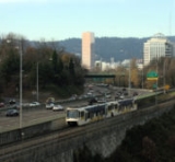
The MAX Red Line is a route in the Metropolitan Area Express light rail
system in the Portland, Oregon
metropolitan area
. It is 25.5 miles (41 km) long. The route, operated by TriMet
, provides an airport rail link
to Portland International Airport
from Beaverton
and downtown Portland
.
was suffering from heavy road traffic coming from increased passenger service, and the Port of Portland
was running out of land for new parking lots, the Port approached TriMet
about bringing MAX to the airport, following through on a plan that dated to highway construction in the 1970s which had left room for such a connection.
The Airport MAX project was born, but the line was delayed after a North-South light rail proposal, part of which is today's MAX Yellow Line
, was defeated at the polls. Instead, the Port and TriMet built the project through a Public-Private Partnership with the Bechtel Corporation. Bechtel agreed to pay for a large portion of the land cost of the line in exchange for rights to the planned Cascades development on empty land that the Port of Portland owned near I-205
and the Airport. Construction started in spring 1999.
The line opened on September 10, 2001, one day before the September 11, 2001 attacks
, which had the side effect of shutting down all air travel in the United States for almost three days. Planned opening ceremonies for the line were cancelled as a result of the attacks.
The section that involved new construction, between the Gateway Transit Center and the airport, is 5.6 miles (9 km) long. Between Gateway and downtown Portland
, the new line used the previously opened tracks and stations of the Eastside MAX line. Red Line service terminated in downtown (Galleria/SW 10th Avenue station) for its first two years of operation.
For much of its length, the new section follows the I-205 freeway. That section of the freeway was completed in the early 1980s, and local planners had included space within the overall right-of-way for a future transitway
, which, at the time, was expected to be a busway; TriMet had not even begun building its first light rail line at that time. This foresight allowed the Airport light rail line to be built at lower costs than might otherwise have been the case, as most of the needed right-of-way was already in public hands. Between the Gateway and Parkrose/Sumner TC stations the tracks pass through a short tunnel, taking them from the east bank of the freeway to the median. The tunnel had been built some 20 years earlier, during the freeway's construction. Had it needed to be built later, it would have been much more costly and lengthened the MAX project's construction time.
tracks, from downtown to the Beaverton Transit Center, to increase capacity between the Gateway area and Beaverton and also to provide a no-transfer airport connection for Westside MAX riders.
Starting in March 2008, three trips in each direction, in each rush hour, were extended west of Beaverton TC, to/from the Hillsboro terminus, Hatfield Government Center station. The reason for this change was to provide additional capacity on that section of the Blue Line, whose ridership was continuing to grow. TriMet still defines the MAX Red Line as being Airport–City Center–Beaverton TC. Those few trips which operate through all the way from the airport to Hillsboro, and vice-versa, are marked in printed public schedules as "blue" trips (shaded in blue) on their Blue Line portions, and the MAX cars display blue signs over most of the trip.
into Vancouver, Washington
.
Light rail
Light rail or light rail transit is a form of urban rail public transportation that generally has a lower capacity and lower speed than heavy rail and metro systems, but higher capacity and higher speed than traditional street-running tram systems...
system in the Portland, Oregon
Portland, Oregon
Portland is a city located in the Pacific Northwest, near the confluence of the Willamette and Columbia rivers in the U.S. state of Oregon. As of the 2010 Census, it had a population of 583,776, making it the 29th most populous city in the United States...
metropolitan area
Portland metropolitan area
The Portland-Vancouver-Hillsboro, OR-WA Metropolitan Statistical Area , also known as the Portland metropolitan area or Greater Portland, is an urban area in the U.S. states of Oregon and Washington centered around the city of Portland, Oregon. The U.S...
. It is 25.5 miles (41 km) long. The route, operated by TriMet
TriMet
TriMet, more formally known as the Tri-County Metropolitan Transportation District of Oregon, is a public agency that operates mass transit in a region that spans most of the Portland metropolitan area in the U.S. state of Oregon...
, provides an airport rail link
Airport rail link
An airport rail link is a service providing passenger rail transport from an airport to a nearby city; by mainline- or commuter trains, rapid transit, people mover or light rail...
to Portland International Airport
Portland International Airport
Portland International Airport is a joint civil-military airport and the largest airport in the U.S. state of Oregon, accounting for 90% of passenger travel and more than 95% of air cargo of the state. It is located within Portland's city limits just south of the Columbia River in Multnomah...
from Beaverton
Beaverton, Oregon
Beaverton is a city in Washington County, Oregon, United States, seven miles west of Portland in the Tualatin River Valley.As of the 2010 census, the population is 90,267. This makes it the second-largest city in the county and Oregon's sixth-largest city...
and downtown Portland
Downtown Portland
Downtown Portland, the city center of Portland, Oregon, United States, is located on the west bank of the Willamette River. It is in the northeastern corner of the southwest section of the city and is where most of the city's high-rise buildings are found....
.
History
When the Portland International AirportPortland International Airport
Portland International Airport is a joint civil-military airport and the largest airport in the U.S. state of Oregon, accounting for 90% of passenger travel and more than 95% of air cargo of the state. It is located within Portland's city limits just south of the Columbia River in Multnomah...
was suffering from heavy road traffic coming from increased passenger service, and the Port of Portland
Port of Portland
Port of Portland may refer to:* Port of Portland * Port of Portland * Portland, Victoria, Australia* Portland Harbour, south England...
was running out of land for new parking lots, the Port approached TriMet
TriMet
TriMet, more formally known as the Tri-County Metropolitan Transportation District of Oregon, is a public agency that operates mass transit in a region that spans most of the Portland metropolitan area in the U.S. state of Oregon...
about bringing MAX to the airport, following through on a plan that dated to highway construction in the 1970s which had left room for such a connection.
The Airport MAX project was born, but the line was delayed after a North-South light rail proposal, part of which is today's MAX Yellow Line
MAX Yellow Line
The MAX Yellow Line is a 5.8-mile route in the Metropolitan Area Express light rail system in Portland, Oregon. The route, which opened May 1, 2004, runs between Portland State University , in downtown Portland, and the Portland Expo Center...
, was defeated at the polls. Instead, the Port and TriMet built the project through a Public-Private Partnership with the Bechtel Corporation. Bechtel agreed to pay for a large portion of the land cost of the line in exchange for rights to the planned Cascades development on empty land that the Port of Portland owned near I-205
Interstate 205 (Oregon-Washington)
Interstate 205 is a loop route that serves the Portland—Vancouver metropolitan area in the U.S. states of Oregon and Washington. I-205 is officially named the War Veterans Memorial Freeway, and is also known as the East Portland Freeway...
and the Airport. Construction started in spring 1999.
The line opened on September 10, 2001, one day before the September 11, 2001 attacks
September 11, 2001 attacks
The September 11 attacks The September 11 attacks The September 11 attacks (also referred to as September 11, September 11th or 9/119/11 is pronounced "nine eleven". The slash is not part of the pronunciation...
, which had the side effect of shutting down all air travel in the United States for almost three days. Planned opening ceremonies for the line were cancelled as a result of the attacks.
The section that involved new construction, between the Gateway Transit Center and the airport, is 5.6 miles (9 km) long. Between Gateway and downtown Portland
Downtown Portland
Downtown Portland, the city center of Portland, Oregon, United States, is located on the west bank of the Willamette River. It is in the northeastern corner of the southwest section of the city and is where most of the city's high-rise buildings are found....
, the new line used the previously opened tracks and stations of the Eastside MAX line. Red Line service terminated in downtown (Galleria/SW 10th Avenue station) for its first two years of operation.
For much of its length, the new section follows the I-205 freeway. That section of the freeway was completed in the early 1980s, and local planners had included space within the overall right-of-way for a future transitway
I-205 Transitway
The I-205 Transitway was a partially built busway along the wide right-of-way of the Interstate 205 freeway in Portland, Oregon. Although it never opened as a busway, its right-of-way is now in use by light rail lines....
, which, at the time, was expected to be a busway; TriMet had not even begun building its first light rail line at that time. This foresight allowed the Airport light rail line to be built at lower costs than might otherwise have been the case, as most of the needed right-of-way was already in public hands. Between the Gateway and Parkrose/Sumner TC stations the tracks pass through a short tunnel, taking them from the east bank of the freeway to the median. The tunnel had been built some 20 years earlier, during the freeway's construction. Had it needed to be built later, it would have been much more costly and lengthened the MAX project's construction time.
Extensions
In September 2003, Red Line service was extended farther west along the existing Blue LineMAX Blue Line
The MAX Blue Line is a 33 mile light rail line in the MAX Light Rail system in the Portland metropolitan area in the U.S. state of Oregon. Operated by TriMet, the line runs between Hillsboro and Gresham, via downtown Portland...
tracks, from downtown to the Beaverton Transit Center, to increase capacity between the Gateway area and Beaverton and also to provide a no-transfer airport connection for Westside MAX riders.
Starting in March 2008, three trips in each direction, in each rush hour, were extended west of Beaverton TC, to/from the Hillsboro terminus, Hatfield Government Center station. The reason for this change was to provide additional capacity on that section of the Blue Line, whose ridership was continuing to grow. TriMet still defines the MAX Red Line as being Airport–City Center–Beaverton TC. Those few trips which operate through all the way from the airport to Hillsboro, and vice-versa, are marked in printed public schedules as "blue" trips (shaded in blue) on their Blue Line portions, and the MAX cars display blue signs over most of the trip.
Future plans
The Red Line may branch up I-205 over the Glenn L. Jackson Memorial BridgeGlenn L. Jackson Memorial Bridge
The Glenn L. Jackson Memorial Bridge, or I-205 bridge, is a segmental bridge that spans the Columbia River between Vancouver, Washington and Portland, Oregon....
into Vancouver, Washington
Vancouver, Washington
Vancouver is a city on the north bank of the Columbia River in the U.S. state of Washington. Incorporated in 1857, it is the fourth largest city in the state with a 2010 census population of 161,791 as of April 1, 2010...
.
External links
- MAX Red Line Project History (brief summary) on TriMet website