

Gibbs Street Pedestrian Bridge
Encyclopedia
Portland, Oregon
Portland is a city located in the Pacific Northwest, near the confluence of the Willamette and Columbia rivers in the U.S. state of Oregon. As of the 2010 Census, it had a population of 583,776, making it the 29th most populous city in the United States...
, Oregon
Oregon
Oregon is a state in the Pacific Northwest region of the United States. It is located on the Pacific coast, with Washington to the north, California to the south, Nevada on the southeast and Idaho to the east. The Columbia and Snake rivers delineate much of Oregon's northern and eastern...
, United States
United States
The United States of America is a federal constitutional republic comprising fifty states and a federal district...
. It will connect the Lair Hill neighborhood with the South Waterfront
South Waterfront
The South Waterfront is a high-rise district under construction on former brownfield industrial land in the South Portland neighborhood south of downtown Portland, Oregon, U.S. It is one of the largest urban redevelopment projects in the United States...
area. It will be a steel box girder bridge
Box girder bridge
A box girder bridge is a bridge in which the main beams comprise girders in the shape of a hollow box. The box girder normally comprises either prestressed concrete, structural steel, or a composite of steel and reinforced concrete. The box is typically rectangular or trapezoidal in cross-section...
, a change from the original plans for an extradosed bridge
Extradosed bridge
An extradosed bridge employs a structure that is frequently described as a cross between a girder bridge and a cable-stayed bridge. The name comes from the French word extradossé, which is derived from the word extrados. Extrados is defined as the exterior curve of an arch.This description is...
, made to reduce the project's cost.
The bridge will cross I-5
Interstate 5 in Oregon
In the U.S. state of Oregon, Interstate 5 traverses the state from north to south, passing through the major cities of Portland, Salem, Eugene, and Medford.-Route description:...
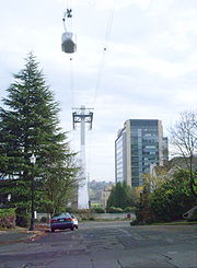
and SW Macadam, and connect SW Kelly Avenue on the west side (one block west of I-5) to SW Moody Avenue on the east side, close to the Portland Aerial Tram
Portland Aerial Tram
The Portland Aerial Tram is an aerial tramway in Portland, Oregon, carrying commuters between the city's South Waterfront district and the main Oregon Health & Science University campus, located in the Marquam Hill neighborhood. It is the second commuter aerial tramway in the United States...
. Construction began in January 2011 and is expected to last about one year.
Background
The project dates back to 2005 with approval of the federal Transportation Equity Act of 2005 which dedicated $5 million to the project.The preliminary design was approved by the Portland City Council on December 3, 2008. It was originally to be an extradosed-type
Extradosed bridge
An extradosed bridge employs a structure that is frequently described as a cross between a girder bridge and a cable-stayed bridge. The name comes from the French word extradossé, which is derived from the word extrados. Extrados is defined as the exterior curve of an arch.This description is...
bridge. In the first round of bidding, the project came in over the budget that the city had allotted for it, and consequently needed to be rescaled. This in turn delayed the timeline and led to a change to simpler design. After undergoing technical engineering design and detailed neighborhood impact assessment, the refined project was opened to bidding in autumn 2010, and the city council awarded a $6.7 million construction contract to Wildish Standard Paving Company of Eugene
Eugene, Oregon
Eugene is the second largest city in the U.S. state of Oregon and the seat of Lane County. It is located at the south end of the Willamette Valley, at the confluence of the McKenzie and Willamette rivers, about east of the Oregon Coast.As of the 2010 U.S...
.
The overall project budget, originally anticipated to be between $7 million and
$11.3 million,
is expected to be met mostly by federal funds, with ten percent local funding. Early public opinion was mixed, but has turned favorable, particularly by those living near the proposed bridge location under the Portland Aerial Tram. One of the provisions of the 2002–2006 tram construction was to bury existing powerlines in the underlying neighborhoods, but those plans were dropped when the highly controversial tram project encountered significant budget overruns. The pedestrian bridge was another mitigating concession promised.
The $11.3 million congressional allotment may have been to also pay for a study to improve access to the Ross Island Bridge
Ross Island Bridge
The Ross Island Bridge is a cantilever truss bridge that spans the Willamette River in Portland, Oregon. It carries U.S. Route 26 across the river between southwest and southeast Portland...
. Eastbound traffic for the bridge frequently clogs the Lair Hill neighborhood while waiting to merge. Mayor Sam Adams has said that whatever funds are left over from the Gibbs Bridge project can be used for studying the Ross Island auto access problem.
Description, usage
To compensate for the elevation difference at the ends of the bridge, an elevator is planned at the South Waterfront end to serve the expected five-story height. It includes a bicycle stairwayBicycle stairway
A bicycle stairway is a pedestrian stairway which also has a channel alongside it to facilitate walking a bicycle up or down the stairway.The channel itself is also often called a wheeling ramp or push ramp...
.
Estimates of existing demand indicate that if the bridge opened in 2009, summertime usage would total 466 crossings per day composed half of bicycle use and half pedestrian use. With school in session, fall usage is expected to increase to 730 crossings per day: 310 by bicycle and 420 pedestrians.
By 2035, usage is estimated at 3,000 to 4,000 crossings per day.
See also
- Caruthers BridgeCaruthers BridgeThe Caruthers Bridge is the working name for a bridge currently under construction across the Willamette River in Portland, Oregon, United States. The bridge will carry MAX light rail, the Portland Streetcar, buses, bicycles, and pedestrians. Private cars and trucks will not be permitted on the...
: a transit and pedestrian bridge being constructed over the Willamette River located 600 metre (0.372823641989884 mi) north of Gibbs Street
External links
- Official project web site by City of Portland