
List of crossings of the Columbia River
Encyclopedia
This is a list of bridge
s and other crossings of the Columbia River
from the Pacific Ocean
upstream to its source.
Bridge
A bridge is a structure built to span physical obstacles such as a body of water, valley, or road, for the purpose of providing passage over the obstacle...
s and other crossings of the Columbia River
Columbia River
The Columbia River is the largest river in the Pacific Northwest region of North America. The river rises in the Rocky Mountains of British Columbia, Canada, flows northwest and then south into the U.S. state of Washington, then turns west to form most of the border between Washington and the state...
from the Pacific Ocean
Pacific Ocean
The Pacific Ocean is the largest of the Earth's oceanic divisions. It extends from the Arctic in the north to the Southern Ocean in the south, bounded by Asia and Australia in the west, and the Americas in the east.At 165.2 million square kilometres in area, this largest division of the World...
upstream to its source.
Crossings
| Photo | Crossing | River mile River mile In the United States, a River mile is a measure of distance in miles along a river from its mouth. River mile numbers begin at zero and increase further upstream. The corresponding metric unit using kilometers is the River kilometer... |
Carries | Location | Coordinates |
|---|---|---|---|---|---|
Oregon - Washington |
|||||
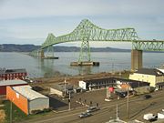 |
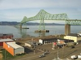
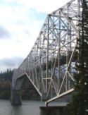
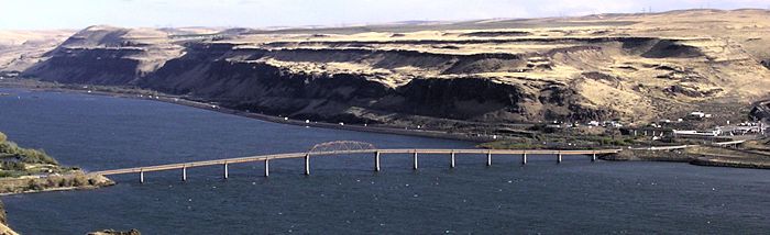
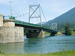
Astoria-Megler Bridge Astoria-Megler Bridge The Astoria–Megler Bridge is a steel girder continuous truss bridge that spans the Columbia River between Astoria, Oregon and Point Ellice near Megler, Washington, in the United States. The span is from the mouth of the river, and was the last segment of U.S. Route 101 between Olympia, Washington... |
 US 101 US 101U.S. Route 101 U.S. Route 101, or U.S. Highway 101, is an important north–south U.S. highway that runs through the states of California, Oregon, and Washington, on the West Coast of the United States... |
Astoria, Oregon Astoria, Oregon Astoria is the county seat of Clatsop County, Oregon, United States. Situated near the mouth of the Columbia River, the city was named after the American investor John Jacob Astor. His American Fur Company founded Fort Astoria at the site in 1811... to Megler, Washington Megler, Washington Megler is a small community located in Pacific County in the U.S. state of Washington. Named for legislator Joseph G. Megler, the community is located at the mouth of the Columbia River on the north shore of the river... |
46.217222°N 123.863056°W | |
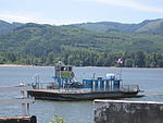 |
Wahkiakum County Ferry | 43.2 |  SR 409 SR 409Washington State Route 409 State Route 409 is a short Washington state highway in Wahkiakum County. The highway runs north from the Wahkiakum County Ferry on Puget Island to SR 4 in the county seat of Cathlamet over a distance of . The route connects Westport, Oregon, which is served by the county ferry, and Cathlamet... |
Westport, Oregon Westport, Oregon Westport is an unincorporated community on the Columbia River in Clatsop County, Oregon, United States. Westport is connected to Cathlamet, Washington across the river via the Wahkiakum County Ferry to Puget Island. U.S... to Puget Island, Washington Puget Island, Washington Puget Island is a 19.365 km² island and unincorporated rural community in the Columbia River in Wahkiakum County, Washington, United States. The Julia Butler Hansen Bridge carries State Route 409 across the Cathlamet Channel to connect the island to the town of Cathlamet, Washington... |
46.13675°N 123.378028°W |
 |
Julia Butler Hansen Bridge Julia Butler Hansen Bridge The Julia Butler Hansen Bridge in Wahkiakum County, Washington connects Cathlamet to Puget Island. It spans the Cathlamet Channel of the Columbia River. Ferry Wahkiakum connects Puget Island to Westport, Oregon... |
SR 409 Washington State Route 409 State Route 409 is a short Washington state highway in Wahkiakum County. The highway runs north from the Wahkiakum County Ferry on Puget Island to SR 4 in the county seat of Cathlamet over a distance of . The route connects Westport, Oregon, which is served by the county ferry, and Cathlamet... |
Puget Island, Washington Puget Island, Washington Puget Island is a 19.365 km² island and unincorporated rural community in the Columbia River in Wahkiakum County, Washington, United States. The Julia Butler Hansen Bridge carries State Route 409 across the Cathlamet Channel to connect the island to the town of Cathlamet, Washington... to Cathlamet, Washington Cathlamet, Washington -Demographics:As of the census of 2000, there were 565 people, 246 households, and 138 families residing in the town. The population density was 1,426.2 people per square mile . There were 278 housing units at an average density of 701.7 per square mile... |
46.19929°N 123.382323°W | |
 |
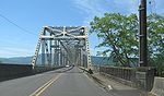
Lewis and Clark Bridge | 66.0 |  SR 433 SR 433Washington State Route 433 State Route 433 is a long state highway located entirely in Cowlitz County, Washington, United States. The highway begins midway across the Columbia River on the National Register of Historic Places listed Lewis and Clark Bridge and travels north to SR 432 in Longview. Prior to the 1964 state... |
Longview, Washington Longview, Washington Longview is a city in Cowlitz County, Washington, United States. It is the principal city of the "Longview, Washington Metropolitan Statistical Area", which encompasses all of Cowlitz County. Longview's population was 36,648 at the time of the 2010 census and is the largest city in Cowlitz County... to Rainier, Oregon Rainier, Oregon Rainier is a city in Columbia County, Oregon, United States. The population was 1,687 at the 2000 census. Rainier is located on the south bank of the Columbia River across from Kelso and Longview, Washington-History:... |
46.10472°N 122.961774°W |
| Burlington Northern Railroad Bridge 9.6 Burlington Northern Railroad Bridge 9.6 Burlington Northern Railroad Bridge 9.6 or BNSF Railway Bridge 9.6, also known as the Columbia River Railroad Bridge, is through truss railway bridge across the Columbia River, between Portland, Oregon, and Vancouver, Washington, owned and operated by BNSF Railway... |
105.6 | BNSF Railway BNSF Railway The BNSF Railway is a wholly owned subsidiary of Berkshire Hathaway Inc., and is headquartered in Fort Worth, Texas. It is one of seven North American Class I railroads and the second largest freight railroad network in North America, second only to the Union Pacific Railroad, its primary... |
Portland, Oregon Portland, Oregon Portland is a city located in the Pacific Northwest, near the confluence of the Willamette and Columbia rivers in the U.S. state of Oregon. As of the 2010 Census, it had a population of 583,776, making it the 29th most populous city in the United States... to Vancouver, Washington Vancouver, Washington Vancouver is a city on the north bank of the Columbia River in the U.S. state of Washington. Incorporated in 1857, it is the fourth largest city in the state with a 2010 census population of 161,791 as of April 1, 2010... |
45.624722°N 122.690833°W | |
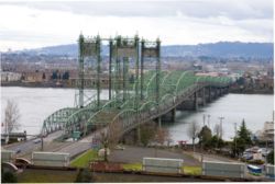 |
Interstate Bridge Interstate Bridge The Interstate Bridge is a pair of nearly identical steel vertical-lift, through-truss bridges that carry Interstate 5 traffic over the Columbia River between Vancouver, Washington, and Portland, Oregon, in the United States... |
106.5 |  I-5 I-5Interstate 5 Interstate 5 is the main Interstate Highway on the West Coast of the United States, running largely parallel to the Pacific Ocean coastline from Canada to Mexico . It serves some of the largest cities on the U.S... |
45.618068°N 122.675138°W | |
 |
Glenn L. Jackson Memorial Bridge Glenn L. Jackson Memorial Bridge The Glenn L. Jackson Memorial Bridge, or I-205 bridge, is a segmental bridge that spans the Columbia River between Vancouver, Washington and Portland, Oregon.... |
112.7 |  I-205 I-205 |
45.593056°N 122.548611°W | |
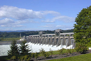 |
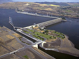
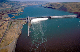
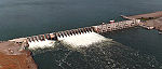
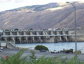
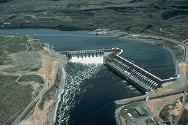
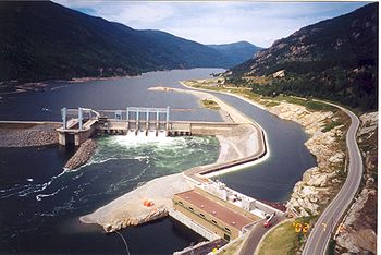
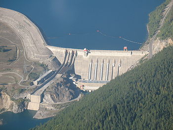
Bonneville Dam Bonneville Dam Bonneville Lock and Dam consists of several run-of-the-river dam structures that together complete a span of the Columbia River between the U.S. states of Oregon and Washington at River Mile 146.1. The dam is located east of Portland, Oregon, in the Columbia River Gorge. The primary functions of... |
147.1 | Lake Bonneville Lake Bonneville (Oregon) Lake Bonneville is a reservoir on the Columbia River in the U.S. states of Oregon and Washington. It was created in 1937 with the construction of Bonneville Dam. The reservoir stretches between it and The Dalles Dam, upstream. It lies in parts of three counties in Oregon and two in Washington .... at Bonneville, Oregon Bonneville, Oregon Bonneville is an unincorporated community in Multnomah County, Oregon, United States, on Interstate 84 and the Columbia River. Bonneville is best known as the site of Bonneville Dam... and North Bonneville, Washington North Bonneville, Washington North Bonneville is a city in Skamania County, Washington, United States. The population was 593 at the 2000 census and 956 at the 2010 census.-Geography:North Bonneville is located at .... |
45.642265°N 121.944792°W | |
 |
Bridge of the Gods Bridge of the Gods (modern structure) The Bridge of the Gods is a steel truss cantilever bridge that spans the Columbia River between Cascade Locks, Oregon and Washington state near North Bonneville. It is approximately 40 miles east of Portland, Oregon and 4 miles upriver from the Bonneville Dam... |
148.3 | Pacific Crest Trail Pacific Crest Trail The Pacific Crest Trail is a long-distance mountain hiking and equestrian trail on the Western Seaboard of the United States. The southern terminus is at the California border with Mexico... |
Cascade Locks, Oregon Cascade Locks, Oregon Cascade Locks is a city in Hood River County, Oregon, United States. The city took its name from a set of locks built to improve navigation past the Cascades Rapids of the Columbia River. The U.S. federal government approved the plan for the locks in 1875, construction began in 1878, and the locks... to near Stevenson, Washington Stevenson, Washington Stevenson is a town in Skamania County, Washington, United States. The population was 1,465 at the 2010 census, a 22% increase over 2000. It is the county seat of Skamania County and home to the Skamania County Court House and Sheriff's Office... |
45.662424°N 121.901276°W |
 |
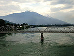
Hood River Bridge Hood River Bridge The Hood River Bridge is a truss bridge with a vertical lift that spans the Columbia River between Hood River, Oregon and White Salmon, Washington.... |
168.8 | Hood River, Oregon Hood River, Oregon The city of Hood River is the seat of Hood River County, Oregon, United States. It is a port on the Columbia River, and is named for the nearby Hood River. As of the 2000 census, the city population was 5,831... to White Salmon, Washington White Salmon, Washington White Salmon is a city in Klickitat County, Washington, United States. It is located in the Columbia River Gorge. The population was 2,193 at the 2000 census and increased 1.4% to 2,224 at the 2010 census.-History:... |
45.717976°N 121.495211°W | |
 |
The Dalles Bridge The Dalles Bridge The Dalles Bridge is a steel cantilever truss bridge that spans the Columbia River between The Dalles, Oregon and Dallesport, Washington. It carries the traffic of U.S. Highway 197.... |
191.3 |  US 197 US 197U.S. Route 197 U.S. Route 197 is a north–south U.S. Route serving Central Oregon and the Columbia Gorge. The route was added in the 1950s. The southern terminus of US 197 is at an intersection with U.S. Route 97 west of Shaniko, Oregon. From US 97, US 197 traverses Wasco County and the cities of Maupin, Tygh... |
The Dalles, Oregon The Dalles, Oregon The Dalles is the largest city and county seat of Wasco County, Oregon, United States. The name of the city comes from the French word dalle The Dalles is the largest city and county seat of Wasco County, Oregon, United States. The name of the city comes from the French word dalle The Dalles is... to Dallesport, Washington Dallesport, Washington Dallesport is a census-designated place in Klickitat County, Washington, United States. The population was 1,202 at the 2010 census.-History:... |
45.610136°N 121.139099°W |
 |
The Dalles Dam | 191.5 | Lake Celilo Lake Celilo Lake Celilo is a long reservoir on the Columbia River in the United States, between the U.S. states of Washington and Oregon. It was created in 1957 with the construction of The Dalles Dam near The Dalles, Oregon, and stretches upstream to the John Day Dam. Its filling drowned the former site of... at The Dalles, Oregon The Dalles, Oregon The Dalles is the largest city and county seat of Wasco County, Oregon, United States. The name of the city comes from the French word dalle The Dalles is the largest city and county seat of Wasco County, Oregon, United States. The name of the city comes from the French word dalle The Dalles is... |
45.612868°N 121.132061°W | |
 |
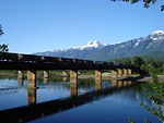
Oregon Trunk Rail Bridge Oregon Trunk Rail Bridge The Oregon Trunk Rail Bridge or Celilo Bridge is a railroad bridge built in 1912 over the Columbia River in the Pacific Northwest of the United States. It consists of eight steel truss spans and several deck girder spans, and includes a vertical-lift section.It is part of the Wishram, Washington... |
200.0 | BNSF Railway BNSF Railway The BNSF Railway is a wholly owned subsidiary of Berkshire Hathaway Inc., and is headquartered in Fort Worth, Texas. It is one of seven North American Class I railroads and the second largest freight railroad network in North America, second only to the Union Pacific Railroad, its primary... |
||
 |
Sam Hill Memorial Bridge Sam Hill Memorial Bridge The Sam Hill Memorial Bridge, also known as the Biggs Rapids Bridge, is a steel truss bridge that carries U.S. Highway 97 across the Columbia River between Biggs Junction, Oregon in Sherman County and Maryhill, Washington in Klickitat County... |
208.2 |  US 97 US 97U.S. Route 97 U.S. Route 97 is a major north–south United States highway in the western United States. It begins at a junction with Interstate 5 at Weed, California, and travels north, ending in Okanogan County, Washington, at the Canadian Border, across from Osoyoos, British Columbia, becoming British... |
Biggs Junction, Oregon Biggs Junction, Oregon Biggs Junction is an unincorporated community in Sherman County, Oregon, United States. For statistical purposes, the United States Census Bureau has defined Biggs Junction as a census-designated place... to Maryhill, Washington |
|
 |
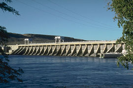
John Day Dam John Day Dam The John Day Dam is a concrete gravity run-of-the-river dam spanning the Columbia River in the northwestern United States. The dam features a navigation lock plus fish ladders on both sides. The John Day Lock has the highest lift of any U.S. lock... |
215.6 | Lake Umatilla Lake Umatilla Lake Umatilla is a long reservoir on the Columbia River in the United States, between the U.S. states of Washington and Oregon. It was created in 1971 with the construction of John Day Dam, and stretches upstream to the McNary Dam. It lies in parts of Sherman, Gilliam, Morrow, and Umatilla... |
45.714722°N 120.693611°W | |
| Umatilla Bridge Umatilla Bridge The Umatilla Bridge is the collective name for a pair of bridges carrying Interstate 82/U.S. Route 395 across the Columbia River at the Washington State/Oregon border... |
290.3 |  I-82 I-82Interstate 82 Interstate 82 is a Interstate Highway that extends from I-90 in Ellensburg, Washington to I-84 near Umatilla, Oregon in the United States. In the state of Washington, it serves the cities of Ellensburg, Yakima, and the Tri Cities , and in Oregon, it serves Umatilla and Hermiston...  US 395 US 395U.S. Route 395 U.S. Route 395 is a U.S. Route in the western United States. The southern terminus of the route is in the Mojave Desert at Interstate 15 near Hesperia. The northern terminus is at the Canadian border near Laurier, where the road becomes Highway 395 upon entering British Columbia. At one time, the... |
Umatilla, Oregon Umatilla, Oregon Umatilla is a city in Umatilla County, Oregon, United States. It is named for the Umatilla River, which enters the Columbia River on the side of the city. The river is named after the Umatilla Tribe. The city is located on the south side of the Columbia River, and is located on U.S... to Plymouth, Washington Plymouth, Washington Plymouth is an unincorporated community in Benton County, Washington, United States. Plymouth is located on the Columbia River across from Umatilla, Oregon. It is south of the Tri-Cities and is served by Interstate 82. It was named by early settlers who felt a nearby rock promontory resembled... |
||
 |
McNary Dam McNary Dam McNary Dam is a 1.4-mile long concrete gravity run-of-the-river dam which spans the Columbia River. It joins Umatilla County, Oregon with Benton County, Washington, 292 miles upriver from the mouth of the Columbia at Astoria, Oregon. It is operated by the U.S. Army Corps of Engineers' McNary... |
292.0 | Lake Wallula Lake Wallula Lake Wallula is a reservoir on the Columbia River in the United States, between the U.S. states of Washington and Oregon. It was created in 1954 with the construction of McNary Dam. It reaches from McNary Dam near the city of Umatilla, Oregon, to the Tri-Cities of Washington.-See also:* Wallula... |
45.929722°N 119.296111°W | |
Washington |
|||||
| Union Pacific Rail bridge | 323.5 | Union Pacific Railway | |||
| BNSF Rail Bridge | 328 | BNSF Railway BNSF Railway The BNSF Railway is a wholly owned subsidiary of Berkshire Hathaway Inc., and is headquartered in Fort Worth, Texas. It is one of seven North American Class I railroads and the second largest freight railroad network in North America, second only to the Union Pacific Railroad, its primary... |
Pasco, Washington Pasco, Washington Pasco is a city in and the county seat of Franklin County, Washington, United States.Pasco is one of three cities that make up the Tri-Cities region of the state of Washington... to Kennewick, Washington Kennewick, Washington Kennewick is a city in Benton County in the southeastern part of the U.S. state of Washington, near the Hanford nuclear site. It is the most populous of the three cities collectively referred to as the Tri-Cities... |
||
 |
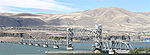
Cable Bridge Cable Bridge The Cable Bridge, officially called the Ed Hendler Bridge and sometimes called the Intercity Bridge, spans the Columbia River between Pasco and Kennewick in southeastern Washington as State Route 397... |
328.5 |  SR 397 SR 397Washington State Route 397 State Route 397 is a state highway in Benton and Frankin counties, in the U.S. state of Washington. It extends from Piert Road in Finley, north on the Cable Bridge over the Columbia River, to Interstate 182 , U.S. Route 12 , and US 395 in Pasco. The route serves as a connector between... |
46.218401°N 119.103813°W | |
| Blue Bridge Blue Bridge (Washington) The Blue Bridge is a four-lane arch-truss bridge connecting Pasco, Washington to Kennewick, Washington. U.S. Route 395 crosses the Columbia River via this bridge. The name comes from the blue paint used on the truss superstructure, with white paint on the suspension beams... |
330 | US 395 U.S. Route 395 in Washington In the U.S. state of Washington, U.S. Route 395 is a major state highway in two parts, separated by a long overlap with Interstate 90 between Ritzville and Spokane. The southern piece, from I-82 near the Tri-Cities to I-90 near Ritzville, is a high-speed four-lane divided highway... |
46.21955°N 119.10404°W | ||
| I-182 Bridge Interstate 182 Bridge The Interstate 182 Bridge, formally known as the Lee-Volpentest Bridges is the collective name for a pair of bridges carrying Interstate 182 over the Columbia River between Pasco and Richland in the U.S. state of Washington. They are named after Glenn C. Lee, publisher of the Tri-City Herald, and... aka Lee-Volpentest Bridges |
336 |  I-182 I-182Interstate 182 Interstate 182 is a Interstate Highway that extends from I-82 west of Richland to US 12 in Pasco. It serves the Tri-Cities. The whole length of I-182 is concurrent with US 12, which extends westwards to Yakima, Naches, and Aberdeen and extends eastwards to Walla Walla, Lewiston, Idaho,...  US 12 US 12U.S. Route 12 in Washington U.S. Route 12 is a major east-west U.S. Highway, running from Aberdeen, Washington, to Detroit, Michigan. It spans across the state of Washington, and is the only numbered highway to span the entire state from west to east, starting near the Pacific Ocean, and crossing the Idaho state line near... |
Pasco, Washington Pasco, Washington Pasco is a city in and the county seat of Franklin County, Washington, United States.Pasco is one of three cities that make up the Tri-Cities region of the state of Washington... to Richland, Washington Richland, Washington Richland is a city in Benton County in the southeastern part of the U.S. state of Washington, at the confluence of the Yakima and the Columbia Rivers. As of the 2010 census, the city population was 48,058. April 1, 2011 estimates from the Washington State Office of Financial Management put the... |
46.263917°N 119.245949°W | |
| Vernita Bridge Vernita Bridge The Vernita Bridge is a bridge on Washington State Route 24 over the Columbia River between Grant County and Benton County, located approximately south of Desert Aire and Mattawa, Washington. The bridge is in the Hanford Reach National Monument near the Hanford Site.-External links:... |
388 |  SR 24 SR 24 |
West of Hanford Site Hanford Site The Hanford Site is a mostly decommissioned nuclear production complex on the Columbia River in the U.S. state of Washington, operated by the United States federal government. The site has been known by many names, including Hanford Works, Hanford Engineer Works or HEW, Hanford Nuclear Reservation... |
||
 |
Mattawa Ropeway Conveyor Mattawa Ropeway Conveyor right|thumbnailThe Mattawa Ropeway Conveyor is a disused ropeway conveyor that crosses the Columbia River. It links Mattawa, Washington to the previous Department of Energy lands west of the Hanford Site. The main mechanism is on the north side of the river.... |
Mattawa, Washington Mattawa, Washington Mattawa is an incorporated city in Grant County, Washington, United States. The population was 2,609 at the 2000 census. An estimated population exists between 4500-6500 residents during peak fruit picking/agricultural season and subsides by approximately 2000 residents during non-picking... to West of Hanford Site Hanford Site The Hanford Site is a mostly decommissioned nuclear production complex on the Columbia River in the U.S. state of Washington, operated by the United States federal government. The site has been known by many names, including Hanford Works, Hanford Engineer Works or HEW, Hanford Nuclear Reservation... |
46.62684°N 119.864298°W | ||
 |
Priest Rapids Dam Priest Rapids Dam Priest Rapids Dam is a hydroelectric, concrete gravity dam; located on the Columbia River, between the Yakima Firing Range and the Hanford Nuclear Reservation, and bridges Yakima County and Grant County, in the U.S. state of Washington. The dam is 24 miles south of the town of Vantage, and 47 miles... |
397.1 | Priest Rapids Lake Priest Rapids Lake Priest Rapids Lake is a reservoir on the Columbia River in the U.S. state of Washington. It was created in 1959 with the construction of Priest Rapids Dam. The reservoir stretches from there upstream to the Wanapum Dam.... |
||
 |
Beverly Railroad Bridge Beverly Railroad Bridge The Beverly Railroad Bridge was constructed by the Chicago, Milwaukee, St. Paul and Pacific Railroad in 1909 during its Pacific Extension... aka Milwaukee Road Bridge |
Former Chicago, Milwaukee, St. Paul and Pacific Railroad Chicago, Milwaukee, St. Paul and Pacific Railroad The Milwaukee Road, officially the Chicago, Milwaukee, St. Paul and Pacific Railroad , was a Class I railroad that operated in the Midwest and Northwest of the United States from 1847 until its merger into the Soo Line Railroad on January 1, 1986. The company went through several official names... |
Beverly, Washington Beverly, Washington Beverly, Washington is a small community along the banks of the Columbia River in central Washington state. The community, which consists of a few hundred residents, is just a few miles downriver from Wanapum Dam and is nestled at the base of what locals call Sentinel Gap, a huge basalt formation... |
46.831111°N 119.948333°W | |
| Wanapum Dam Wanapum Dam Wanapum Dam is a hydroelectric project located on the Columbia River downstream from Vantage, Washington where Interstate 90 crosses the Columbia from Grant County into Kittitas County. It is owned by the Grant County Public Utility District. Its reservoir is named Lake Wanapum.The dam, and its... |
415.8 | Lake Wanapum Lake Wanapum Wanapum Lake is a reservoir on the Columbia River in the U.S. state of Washington. It was created in 1963 with the construction of Wanapum Dam. It stretches from there upstream to the Rock Island Dam. The lake is named for the Wanapum people.... |
46.875213°N 119.971004°W | ||
| Vantage Bridge Vantage Bridge The Vantage Bridge is a bridge in the U.S. state of Washington. It carries Interstate 90 across the Columbia River, near Vantage and George, Washington. This section of the river is named Wanapum Lake; it is the reservoir formed by Wanapum Dam... |
 I-90 I-90Interstate 90 in Washington Interstate 90 , a transcontinental Interstate Highway from Seattle, Washington, to Boston, Massachusetts, crosses the state of Washington before crossing the Idaho state line between Spokane and Post Falls... |
Vantage, Washington Vantage, Washington Vantage is a census-designated place in Kittitas County, Washington, United States. The population was 70 at the 2000 census.-History:The area around Vantage has been occupied by the Wanapum Native Americans since prehistory. A number of well-preserved rock-paintings have been found on the cliff... |
46.942293°N 119.973106°W | ||
 |
Rock Island Dam Rock Island Dam Rock Island Dam is a hydroelectric dam on the Columbia River in the U.S. state of Washington. Chelan County Public Utility District's Rock Island Dam and Hydro Project was the first dam to span the Columbia, having been built from 1929 to 1933. It is located near the geographical center of... |
453.4 | Rock Island Pool Rock Island Pool Rock Island Pool is a reservoir on the Columbia River in the U.S. state of Washington. It was created in 1933 with the construction of Rock Island Dam. The reservoir stretches from there upstream to the Rocky Reach Dam.... |
47.342155°N 120.094773°W | |
| Rock Island Railroad Bridge | BNSF Railway BNSF Railway The BNSF Railway is a wholly owned subsidiary of Berkshire Hathaway Inc., and is headquartered in Fort Worth, Texas. It is one of seven North American Class I railroads and the second largest freight railroad network in North America, second only to the Union Pacific Railroad, its primary... |
Rock Island, Washington Rock Island, Washington Rock Island is a city in Douglas County, Washington, United States. It is part of the Wenatchee–East Wenatchee Metropolitan Statistical Area. The population was 863 at the 2000 census.-History:... |
47.3668611111°N 120.153722222°W | ||
 |
Senator George Sellar Bridge Senator George Sellar Bridge The Senator George Sellar Bridge, also known as the Columbia River Bridge at Wenatchee, Washington was built in 1950 to carry U.S. Route 2 across the Columbia River. The steel suspended tied-arch bridge has a main span of with anchor arms... |
 SR 285 SR 285Washington State Route 285 State Route 285 is a state highway in the U.S. state of Washington. It follows the old route of U.S. Route 2 through Wenatchee.-Major intersections:-References:... |
Wenatchee, Washington Wenatchee, Washington Wenatchee is located in North Central Washington and is the largest city and county seat of Chelan County, Washington, United States. The population within the city limits in 2010 was 31,925... to East Wenatchee, Washington East Wenatchee, Washington East Wenatchee is a city in Douglas County, Washington, United States along the northern banks of the Columbia River. The population at the 2010 census was 13,190, a 129.1% increase over the 2000 census.... |
||
| Old Wenatchee Bridge Columbia River Bridge (Wenatchee, Washington) The Columbia River Bridge at Wenatchee, Washington, also known as the Old Wenatchee Bridge, was built by the Washington Bridge Company in 1908, primarily as a means to carry irrigation water pipelines across the Columbia River. It was the first road bridge over the Columbia south of Canada... |
Pedestrian, water pipeline | ||||
| Richard Odabashian Bridge |  US 2 US 2U.S. Route 2 in Washington U.S. Route 2 is a part of the United States Numbered Highway System that has a western segment that runs from Everett, Washington, to the Upper Peninsula of the US state of Michigan. In Washington, it is a state highway that begins at in Downtown Everett. The of US 2 that lie within... US 97U.S. Route 97 in Washington In the U.S. state of Washington, U.S. Route 97 is a route which traverses from the Oregon state line at the northern end of the Sam Hill Memorial Bridge in Maryhill, north to the Canadian border in Okanogan County near Oroville... |
||||
 |
Rocky Reach Dam Rocky Reach Dam Rocky Reach Dam is a hydroelectric dam in the U.S. state of Washington. Chelan County Public Utility District's Rocky Reach Dam and Hydro Project is located in north central Washington state, USA on the Columbia River, about seven miles upstream from the city of Wenatchee... |
473.7 | Lake Entiat Lake Entiat Lake Entiat is a reservoir between Chelan County and Douglas County in North Central Washington that is formed above Rocky Reach Dam , a hydroelectric dam on the Columbia River. The reservoir is north of Wenatchee and stretches upstream to the Wells Dam. Lincoln Rock State Park is on its east... |
47.533264°N 120.294424°W | |
| Beebe Bridge Beebe Bridge The Beebe Bridge is a two-lane, steel highway bridge crossing the Columbia River at Chelan Falls, Washington. Located three miles east of Lake Chelan, the bridge is part of U.S. Route 97 and averages 5000 vehicle crossings per day.... |
US 97 U.S. Route 97 in Washington In the U.S. state of Washington, U.S. Route 97 is a route which traverses from the Oregon state line at the northern end of the Sam Hill Memorial Bridge in Maryhill, north to the Canadian border in Okanogan County near Oroville... |
Chelan, Washington Chelan, Washington Chelan is a city in Chelan County, Washington, United States. The population was 3,890 at the 2010 census. It sits on the southeast tip of Lake Chelan, where the lake flows into the Chelan River.... |
|||
 |
Wells Dam Wells Dam Wells Dam is a hydroelectric dam located on the Columbia River, downstream from the confluence of the Okanogan River, Methow River, and the Columbia River in Washington State. The dam, associated structures, and machinery make up the Wells Hydroelectric Project. It is owned and operated by... |
515.1 | Lake Pateros Lake Pateros Lake Pateros is a reservoir on the Columbia River in the U.S. state of Washington. It was created in 1967 with the construction of Wells Dam. The reservoir lies almost entirely in Douglas and Okanogan counties, although the dam itself lies partially in the easternmost portion of Chelan County. The... |
47.9454°N 119.866°W | |
| Brewster Bridge |  SR 173 SR 173Washington State Route 173 State Route 173 is a state highway in the U.S. state of Washington, running from SR 17 in Bridgeport to US 97 in Brewster.-Route description:... |
Brewster, Washington Brewster, Washington Brewster is a city in Okanogan County, Washington, United States. The population was 2,370 at the 2010 census.-History:In 1811, John Jacob Astor's Pacific Fur Company established Fort Okanogan just north of the present site of Brewster, which was the first American post in Washington... |
|||
 |
Bridgeport Bridge Columbia River Bridge (Bridgeport, Washington) The Columbia River Bridge, also known as the Bridgeport Bridge, at Bridgeport, Washington was built to span the Columbia River in 1950. Composed of three spans, the bridge is a steel continuous riveted deck truss carrying Washington State Route 17 on a wide roadway and two sidewalks. The center... |
 SR 17 SR 17 |
Bridgeport, Washington Bridgeport, Washington Bridgeport is a city in Douglas County, Washington, United States. It is part of the Wenatchee–East Wenatchee Metropolitan Statistical Area. Bridgeport's population was 2,059 at the 2000 census.Bridgeport is located near the Chief Joseph Dam.-History:... |
||
 |
Chief Joseph Dam Chief Joseph Dam The Chief Joseph Dam is a concrete gravity dam on the Columbia River, upriver from Bridgeport, Washington, USA. The dam was authorized as Foster Creek Dam and Powerhouse for power generation and irrigation by the River and Harbor Act of 1946... |
545.1 | Rufus Woods Lake | 47.995206°N 119.63321°W | |
 |
Grand Coulee Bridge Grand Coulee Bridge The Grand Coulee Bridge, or Columbia River Bridge at Grand Coulee Dam, is a thru-cantilever steel truss bridge built in 1935. It carries Washington State Route 155. It is near the city of Grand Coulee, Washington and the Grand Coulee Dam. In 1982, it was added to the National Register of Historic... |
 SR 155 SR 155Washington State Route 155 State Route 155 is a state highway in the U.S. state of Washington, running from U.S. Route 2 in Fordair over Disautel Pass to U.S. Route 97 and State Route 20 in the city of Omak. It is the main north–south route through the area around Grand Coulee Dam.-Route description:State Route 155... |
Coulee Dam, Washington Coulee Dam, Washington Coulee Dam is a town in Douglas, Grant, and Okanogan counties in the U.S. state of Washington. The Douglas County portion of Coulee Dam is part of the Wenatchee–East Wenatchee, Washington Metropolitan Statistical Area. The population was 1,098 as of the 2010 census.-History:Coulee Dam was... |
||
 |
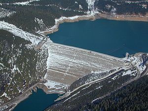
Grand Coulee Dam Grand Coulee Dam Grand Coulee Dam is a gravity dam on the Columbia River in the U.S. state of Washington built to produce hydroelectric power and provide irrigation. It was constructed between 1933 and 1942, originally with two power plants. A third power station was completed in 1974 to increase its energy... |
596.6 | Franklin D. Roosevelt Lake Franklin D. Roosevelt Lake Franklin D. Roosevelt Lake is the reservoir created in 1941 by the impoundment of the Columbia River by the Grand Coulee Dam in Washington state. It is named for Franklin D. Roosevelt, who was President during the construction of the dam... |
47.956667°N 118.983333°W | |
 |
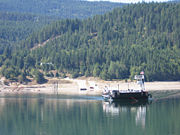
Keller-Wilbur Ferry |  SR 21 SR 21 |
Keller, Washington Keller, Washington Keller is an unincorporated community in southeastern Ferry County in the northeastern part of the U.S. state of Washington.-History:The town is located in the San Poil Valley , and was founded in 1898 by John C. Keller, a local businessman... to Wilbur, Washington Wilbur, Washington Wilbur is a town in Lincoln County, Washington, United States. The population was 884 at the 2010 census.-History:Just prior to the construction of the Central Washington Railroad line in 1889, no towns existed west of Davenport in Lincoln County. One place along the line, "Wild Goose Bill's... |
||
| Gifford-Inchelium Ferry Gifford-Inchelium Ferry The Gifford-Inchelium Ferry, also known as GIF, is a ferry across the Columbia River in Washington State.The Colville Confederated Tribes operate this ferry across Roosevelt Lake on the upper Columbia. It connects Inchelium, Washington to State Route 25 across the river. The fare to ride is free.... |
Gifford, Washington Gifford, Washington Gifford is an unincorporated community in Stevens County, Washington, United States. Gifford is located across the Columbia River from Inchelium. The community is served by Washington State Route 25. Gifford has a post office with ZIP code 99131.... to Inchelium, Washington Inchelium, Washington Inchelium is a census-designated place in Ferry County, Washington, United States on the Colville Indian Reservation. The population was 409 at the 2010 census.... |
||||
| Kettle Falls Bridges Kettle Falls Bridges The Kettle Falls Bridges is the collective name for a pair of steel cantilever bridges carrying State Route 20/U.S. Route 395 and the BNSF Railway across the Columbia River at Kettle Falls, Washington. The south bridge carries motor vehicle traffic while the similar northern span is used for... |
US 395 U.S. Route 395 in Washington In the U.S. state of Washington, U.S. Route 395 is a major state highway in two parts, separated by a long overlap with Interstate 90 between Ritzville and Spokane. The southern piece, from I-82 near the Tri-Cities to I-90 near Ritzville, is a high-speed four-lane divided highway...  SR 20 SR 20BNSF Railway BNSF Railway The BNSF Railway is a wholly owned subsidiary of Berkshire Hathaway Inc., and is headquartered in Fort Worth, Texas. It is one of seven North American Class I railroads and the second largest freight railroad network in North America, second only to the Union Pacific Railroad, its primary... |
Kettle Falls, Washington Kettle Falls, Washington Kettle Falls is a city in Stevens County, Washington, United States, named for the nearby Kettle Falls on the Columbia River, an ancient and important fishing site for Native Americans... |
|||
| Northport Bridge Northport Bridge The Northport Bridge spans the Columbia River near Northport, Washington, close to the border with Canada. The steel cantilever through-truss bridge replaced an 1897 timber bridge, and was completed in 1951. It carries Washington State Route 25... |
 SR 25 SR 25Washington State Route 25 State Route 25 , named the Coulee Reservoir Highway, is a long state highway serving communities in Lincoln and Stevens counties in the U.S. state of Washington. The highway begins at an intersection with east of Davenport and continues northwest to cross the Spokane River on the Spokane... |
Northport, Washington Northport, Washington Northport is a town in Stevens County, Washington, United States. The population was 295 at the 2010 census.-History:Northport was given its name since it was once the northernmost town on the Spokane Falls and Northern Railway... |
|||
British Columbia |
|||||
 |
Trail Bridge | Hwy 3B Hwy 22A |
Trail, British Columbia Trail, British Columbia Trail is a city in the West Kootenay region of the Interior of British Columbia, Canada.-Geography:Trail has an area of . The city is located on both banks of the Columbia River, approximately 10 km north of the United States border. This section of the Columbia River valley is located between the... |
||
| Kinnaird Bridge | Crowsnest Highway Crowsnest Highway The Crowsnest Highway, also known as the Interprovincial or, in British Columbia, the Southern Trans-Provincial, is an east-west highway, in length, through the southern parts of British Columbia and Alberta, providing the shortest highway connection between British Columbia's Lower Mainland and... |
Castlegar, British Columbia Castlegar, British Columbia Castlegar is the second largest city in the West Kootenay region of British Columbia, Canada. It is located within the Selkirk Mountains at the confluence of the Kootenay and Columbia Rivers. It is a regional trade and transportation centre, with a local economy fueled by forestry, mining and tourism... |
|||
| Rail bridge | Canadian Pacific Railway Canadian Pacific Railway The Canadian Pacific Railway , formerly also known as CP Rail between 1968 and 1996, is a historic Canadian Class I railway founded in 1881 and now operated by Canadian Pacific Railway Limited, which began operations as legal owner in a corporate restructuring in 2001... |
Castlegar, British Columbia Castlegar, British Columbia Castlegar is the second largest city in the West Kootenay region of British Columbia, Canada. It is located within the Selkirk Mountains at the confluence of the Kootenay and Columbia Rivers. It is a regional trade and transportation centre, with a local economy fueled by forestry, mining and tourism... to Robson, British Columbia Robson, British Columbia Robson is an unincorporated settlement in the West Kootenay region of British Columbia, Canada. It is immediately north across the Columbia River from the city of Castlegar, on the west bank of the mouth of Pass Creek. Across Pass Creek on the same side of the Columbia is Raspberry, which was... |
|||
| Castlegar-Robson Bridge | Broadwater Rd. | ||||
 |
Keenleyside Dam Keenleyside Dam Hugh Keenleyside Dam is a hydroelectric dam spanning the Columbia River, 12 km upstream of the city of Castlegar, British Columbia, Canada.... |
780.0 | North of Castlegar, British Columbia Castlegar, British Columbia Castlegar is the second largest city in the West Kootenay region of British Columbia, Canada. It is located within the Selkirk Mountains at the confluence of the Kootenay and Columbia Rivers. It is a regional trade and transportation centre, with a local economy fueled by forestry, mining and tourism... |
||
 |
Needles Cable Ferry | Hwy 6 | Needles, British Columbia to Fauquier, British Columbia Fauquier, British Columbia Fauquier is a settlement in British Columbia. It is located on the east side of Lower Arrow Lake along Highway 6, where a car ferry links to the west side of the lake.... |
||
| Arrow Park Ferry | West Arrow Park to East Arrow Park |
||||
| Upper Arrow Lakes Ferry | Galena Bay, British Columbia Galena Bay, British Columbia Galena Bay is an unincorporated locality on the bay of the same name on Upper Arrow Lake in British Columbia, Canada.Galena Bay is the location of a terminal of the Upper Arrow Lakes Ferry. This linking Galena Bay to Shelter Bay, the link forming part of British Columbia Highway 23 from Nakusp to... to Shelter Bay, British Columbia Shelter Bay, British Columbia Shelter Bay is a ferry landing and unincorporated locality on Upper Arrow Lake in British Columbia, Canada.It serves as one terminus of the Upper Arrow Lakes Ferry, that crosses the lake to Galena Bay. This ferry connects British Columbia Highway 23 from Revelstoke to that highway's continuation... |
||||
 |
Big Eddy Bridge | Big Eddy Rd. | Revelstoke, British Columbia Revelstoke, British Columbia Revelstoke is a city in southeastern British Columbia, Canada. It is located east of Vancouver, and west of Calgary, Alberta. The city is situated on the banks of the Columbia River just south of the Revelstoke Dam and near its confluence with the Illecillewaet River... |
||
 |
Rail bridge | Canadian Pacific Railway Canadian Pacific Railway The Canadian Pacific Railway , formerly also known as CP Rail between 1968 and 1996, is a historic Canadian Class I railway founded in 1881 and now operated by Canadian Pacific Railway Limited, which began operations as legal owner in a corporate restructuring in 2001... |
|||
 |
Revelstoke Bridge | Trans-Canada Highway Trans-Canada Highway The Trans-Canada Highway is a federal-provincial highway system that joins the ten provinces of Canada. It is, along with the Trans-Siberian Highway and Australia's Highway 1, one of the world's longest national highways, with the main route spanning 8,030 km... Hwy 23 |
|||
 |
Revelstoke Dam Revelstoke Dam The Revelstoke Dam, also known as Revelstoke Canyon Dam, is a hydroelectric dam spanning the Columbia River, 5 km north of Revelstoke, British Columbia, Canada. The powerhouse was completed in 1984 and has a generating capacity of 2480 MW. Four generating units were installed initially, with one... |
934.0 | Revelstoke Lake Revelstoke Lake Lake Revelstoke or Revelstoke Lake or Revelstoke Lake Reservoir is an artificial lake on the Columbia River, north of the town of Revelstoke, British Columbia and south of Mica Creek... |
||
 |
Mica Dam Mica Dam The Mica Dam is a hydroelectric dam spanning the Columbia River 135 kilometres north of Revelstoke, British Columbia, Canada. Completed in 1973 under the terms of the 1964 Columbia River Treaty, the Mica powerhouse has a generating capacity of . The dam is operated by BC Hydro... |
1018.0 | Mica Creek, British Columbia Mica Creek, British Columbia Mica Creek is a small village in British Columbia, Canada that was used as a base of operations for the construction of the Mica Dam hydroelectric project by BC Hydro in the 1960s and 1970s. It is located 148 km north of Revelstoke, British Columbia on Highway 23 and situated at the... |
||
| Rail bridge | Canadian Pacific Railway Canadian Pacific Railway The Canadian Pacific Railway , formerly also known as CP Rail between 1968 and 1996, is a historic Canadian Class I railway founded in 1881 and now operated by Canadian Pacific Railway Limited, which began operations as legal owner in a corporate restructuring in 2001... |
Donald, British Columbia Donald, British Columbia Donald, British Columbia is located on Highway 1, 28 kilometers west of Golden. In its heyday, Donald was a divisional point on the Canadian Pacific Railway... |
|||
| Donald Bridge | Trans-Canada Highway Trans-Canada Highway The Trans-Canada Highway is a federal-provincial highway system that joins the ten provinces of Canada. It is, along with the Trans-Siberian Highway and Australia's Highway 1, one of the world's longest national highways, with the main route spanning 8,030 km... |
||||
| Kicking Horse Drive Bridge | Kicking Horse Dr. | Golden, British Columbia Golden, British Columbia Golden is a town in southeastern British Columbia, Canada, located west of Calgary, Alberta and east of Vancouver.-History:Much of the town's history is tied into the Canadian Pacific Railway and the logging industry... |
|||
| Canyon Creek Bridge | Nicholson, British Columbia | ||||
| Parson Bridge | Parson River Crossing Rd. | Parson, British Columbia | |||
| Spillimacheen Bridge | Westside Rd. | Spillimacheen, British Columbia Spillimacheen, British Columbia Spillimacheen is an unincorporated settlement in the Columbia Valley of British Columbia, Canada. It is located at the confluence of the Spillimacheen and Columbia Rivers, upstream from and southeast of the town of Golden.-References:... |
|||
| Botts Channel Bridge | Brisco Rd. | Brisco, British Columbia | |||
| Brisco Road Bridge | Brisco Rd. | ||||
| Athalmer Bridge | Athalmer Rd. | Athalmer, British Columbia to Invermere, British Columbia Invermere, British Columbia Invermere is a community in eastern British Columbia, Canada, near the border of Alberta. With its growing permanent population of almost 4,000 , swelling to near 40,000 on summer weekends, it is the hub of the Columbia Valley between Golden, and Cranbrook... |
|||
| Fairmont Bridge | Hwy 93 Hwy 95 |
Fairmont, British Columbia | |||