
Trams in Sydney
Encyclopedia
- This is an historical article about the now closed tramways of Sydney. For the current light rail line, see Metro Light RailMetro Light RailThe Metro Light Rail is the only currently operating light rail line in Sydney. The line opened on 31 August 1997, mostly along the route of an unused goods railway line, to serve the redeveloped inner-city areas of Darling Harbour, Ultimo and Pyrmont, and was extended in 2000 to serve some of...
.
The Sydney tramway network once served Sydney
Sydney
Sydney is the most populous city in Australia and the state capital of New South Wales. Sydney is located on Australia's south-east coast of the Tasman Sea. As of June 2010, the greater metropolitan area had an approximate population of 4.6 million people...
, the capital city
Capital City
Capital City was a television show produced by Euston Films which focused on the lives of investment bankers in London living and working on the corporate trading floor for the fictional international bank Shane-Longman....
of New South Wales
New South Wales
New South Wales is a state of :Australia, located in the east of the country. It is bordered by Queensland, Victoria and South Australia to the north, south and west respectively. To the east, the state is bordered by the Tasman Sea, which forms part of the Pacific Ocean. New South Wales...
, Australia
Australia
Australia , officially the Commonwealth of Australia, is a country in the Southern Hemisphere comprising the mainland of the Australian continent, the island of Tasmania, and numerous smaller islands in the Indian and Pacific Oceans. It is the world's sixth-largest country by total area...
. In its heyday, it was the largest in Australia, the second largest in the Commonwealth
Commonwealth
Commonwealth is a traditional English term for a political community founded for the common good. Historically, it has sometimes been synonymous with "republic."More recently it has been used for fraternal associations of some sovereign nations...
(after London
London
London is the capital city of :England and the :United Kingdom, the largest metropolitan area in the United Kingdom, and the largest urban zone in the European Union by most measures. Located on the River Thames, London has been a major settlement for two millennia, its history going back to its...
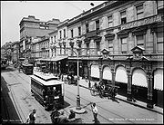
), and one of the largest in the world. It was extremely intensively worked, with about 1,600 cars in service at any one time at its peak during the 1930s (cf. about 500 trams in Melbourne
Trams in Melbourne
The Melbourne tramway network is a major form of public transport in Melbourne, the capital city of the state of Victoria, Australia. , the network consisted of of track, 487 trams, 28 routes, and 1,773 tram stops. It was therefore the largest urban tramway network in the world, ahead of the...
today).
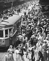
Throughout the first half of the twentieth century, an average of more than one tram journey per day was made in Sydney by every man and woman, infant and child in the city. Patronage peaked in 1945 at 405 million passenger journeys. The system was in place from 1879 until its winding down in the 1950s and closure in 1961 (a single horse-car line operated from 1861 to 1866). It had a maximum street mileage of 181 miles (291 km), in 1923.
In 1997, more than 30 years after trams disappeared from Sydney streets, the Metro Light Rail
Metro Light Rail
The Metro Light Rail is the only currently operating light rail line in Sydney. The line opened on 31 August 1997, mostly along the route of an unused goods railway line, to serve the redeveloped inner-city areas of Darling Harbour, Ultimo and Pyrmont, and was extended in 2000 to serve some of...
, a privately owned single line, opened. There have been various proposals to extend this line into the CBD
Sydney central business district
The Sydney central business district is the main commercial centre of Sydney, New South Wales, Australia. It extends southwards for about 3 kilometres from Sydney Cove, the point of first European settlement. Its north–south axis runs from Circular Quay in the north to Central railway station in...
and inner suburbs
Inner West (Sydney)
The Inner West is a general term which is used to describe the metropolitan area directly to the west of the Sydney central business district, New South Wales, Australia...
with a recently approved line extension to Dulwich Hill and a new on road loop service via George Street, Circular Quay, Barangaroo
Barangaroo, New South Wales
Barangaroo is an inner-city area of Sydney, in the state of New South Wales, Australia. It is located on the north-western edge of the Sydney central business district and the southern end of the Sydney Harbour Bridge...
, and Chinatown to be installed. Another route to Leichardt was also proposed during 1999.
Early tramways
Sydney's first tram was horse-drawn, running from the old Sydney Railway station to Circular Quay along Pitt StreetPitt Street, Sydney
Pitt Street is a major street in central Sydney, New South Wales, Australia. The street runs through the entire city centre from Circular Quay in the north to Waterloo, although today's street is in two disjointed sections after a substantial stretch of it was removed to make way for Sydney's...
. Built in 1861, the design was compromised by the desire to haul railway freight wagons along the line to supply city businesses, in addition to passenger traffic. This resulted in a track that protruded from the road surface and damaged the wheels of wagons trying to cross it. Hard campaigning by competing omnibus
Bus
A bus is a road vehicle designed to carry passengers. Buses can have a capacity as high as 300 passengers. The most common type of bus is the single-decker bus, with larger loads carried by double-decker buses and articulated buses, and smaller loads carried by midibuses and minibuses; coaches are...
owners - as well as a fatal accident involving the leading Australian musician Isaac Nathan
Isaac Nathan
Isaac Nathan was an Anglo-Australian composer, musicologist, journalist and self-publicist, who ended an eventful career by becoming the "father of Australian music".-Early success:...
in 1864 - led to closure in 1866.
In 1879 a steam tramway was established. Despite several accidents, it was a great success and the system expanded rapidly through the city and inner suburbs. The trams comprised a Baldwin
Baldwin Locomotive Works
The Baldwin Locomotive Works was an American builder of railroad locomotives. It was located in Philadelphia, Pennsylvania, originally, and later in nearby Eddystone, Pennsylvania. Although the company was very successful as a producer of steam locomotives, its transition to the production of...
locomotive
Locomotive
A locomotive is a railway vehicle that provides the motive power for a train. The word originates from the Latin loco – "from a place", ablative of locus, "place" + Medieval Latin motivus, "causing motion", and is a shortened form of the term locomotive engine, first used in the early 19th...
hauling one or more double-deck carriages. A preserved Baldwin steam tram motor is at the Powerhouse Museum
Powerhouse Museum
The Powerhouse Museum is the major branch of the Museum of Applied Arts and Sciences in Sydney, the other being the historic Sydney Observatory...
"Discovery Centre" at Castle Hill, and there is an operational steam motor and trailer set at the Valley Heights Steam Tramway Museum
Valley Heights Locomotive Depot Heritage Museum
The Valley Heights Locomotive Depot Heritage Museum is a railway museum located in Valley Heights, New South Wales, Australia. It is operated by the Blue Mountains Division of the New South Wales Rail Transport Museum....
, in the Blue Mountains near Sydney. Another is at MOTAT, Auckland. There were also two cable tram routes, to Ocean Street (Edgecliff
Edgecliff
Edgecliff may refer to:* Edgecliff , historic building* Edgecliff College* Edgecliff Village, Texas* Edgecliff, New South Wales...
) and in North Sydney
North Sydney, New South Wales
North Sydney is a suburb and commercial district on the Lower North Shore of Sydney, in the state of New South Wales, Australia. North Sydney is located 3 kilometres north of the Sydney central business district and is the administrative centre for the local government area of North Sydney...
, later extended to Crows Nest
Crows Nest, New South Wales
Crows Nest is a suburb on the lower North Shore of Sydney, New South Wales, Australia. Crows Nest is located 5 kilometres north of the Sydney central business district, in the local government area of North Sydney Council.-History:...
, because of the steep terrain involved.
Additionally, horse trams operated between Newtown
Newtown, New South Wales
Newtown, a suburb of Sydney's inner west is located approximately four kilometres south-west of the Sydney central business district, straddling the local government areas of the City of Sydney and Marrickville Council in the state of New South Wales, Australia....
and St Peters
St Peters, New South Wales
St Peters is a suburb in the inner west of Sydney, in the state of New South Wales, Australia. St Peters is located 7 kilometres south of the Sydney central business district, in the local government area of Marrickville Council.-History:...
railway stations in the 1890s and between Manly
Manly, New South Wales
Manly is a suburb of northern Sydney, in the state of New South Wales, Australia. Manly is located 17 kilometres north-east of the Sydney central business district and is the administrative centre of the local government area of Manly Council, in the Northern Beaches region.-History:Manly was named...
and North Manly from 1903 to 1907. These two instances were replacements of existing steam trams during periods of low patronage.
Electrification
Electrification started in 1898, and most of the system was converted by 1910- the privately owned Parramatta line built by Charles Edward Jeanneret in 1881 to Redbank Wharf (Duck River) steam tram remained until 1943. Service began with C-class saloon cars, followed by D-class combination cars. In contrast to other cities that started with combination cars and toastracks, then quickly abandoned them for drop-centre and saloon cars, Sydney started by going the other way. Footboard trams continued to be introduced, notably E-class, K-class, and the double-bogie cars O-class and P-class trams required the conductor to collect fares from the footboard of the car, as those trams had no corridor. Revered though those trams were, they were deathtraps for conductors. On average, each day one conductor fell or was knocked off the footboard by passing motor vehicles. The majority suffered a fractured skull. In the three years 1923, 1924, 1925, there were 282, 289, and 233 accidents respectively to conductors on N.S.W. tramways. From 1916 to 1932, there were 4097 accidents to tram employees, and from 1923 to 1931 there were 10,228 accidents to passengers having falls when alighting or boarding. 63 of the falls were fatal. Of the more than 100 falls reported of conductors, one quarter died from their injuries. It was not until the 1930s with the introduction of the R-class that the drop-centre saloon tram, widely used elsewhere in Australia, came to Sydney. Even so, footboard trams continued in wide use until the late 1950s, despite calls as early as 1934 by the tram union for them to be modified.
Demise and closure
By the 1920s, the system had reached its maximum extent. In many ways, the Sydney tram system was a victim of its own success. The overcrowded and heaving trams running at a high frequency, in competition with growing private motor car and bus use, created congestion. Competition from the private car, private bus operators and the perception of traffic congestion led to the gradual closure of lines from the late 1930s. Overseas transport experts were called upon to advise the city on its post-war transport issues and recommended closure of the system. Closure was supported by the NRMANRMA
NRMA refers to either of two historically related Australian companies:*The National Roads and Motorists' Association, known as NRMA Motoring and Services, is a member-owned mutual organisation offering , motoring advice and other services in New South Wales and the Australian Capital...
, but generally went against public opinion. Nevertheless, closure became Labor government policy and the system was wound down in stages, with withdrawal of the last service, to La Perouse
La Perouse, New South Wales
Lapérouse is a suburb in south-eastern Sydney, in the state of New South Wales, Australia. The suburb of Lapérouse is located about 14 kilometres south-east of the Sydney central business district, in the City of Randwick....
, in 1961.
Circular Quay - Railway Central Station Colonnade (via Pitt and Castlereagh Streets)
This was an extremely busy service for passengers transferring from suburban trains at Central, particularly prior to the opening of the city underground railway lines in 1926. Trams operated from Central station down Castlereagh Street to Circular Quay and back up Pitt Street in a large anti-clockwise loop. These tracks were also used as the city route for some eastern and southwestern routes during busy periods. The line made use of the sandstone viaduct onto the colonnade at Central station, used by the Metro Light RailMetro Light Rail
The Metro Light Rail is the only currently operating light rail line in Sydney. The line opened on 31 August 1997, mostly along the route of an unused goods railway line, to serve the redeveloped inner-city areas of Darling Harbour, Ultimo and Pyrmont, and was extended in 2000 to serve some of...
since 1997, but in the opposite direction.
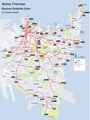
Eastern Suburbs Lines
Sydney Ferries
Sydney Ferries is an agency of the New South Wales Government Department of Transport, providing ferry services on Sydney Harbour and the Parramatta River in Sydney, Australia....
. For many years, 27 regular services operated from Circular Quay. A number of full-time services also operated from a secondary terminus at 'Railway' (Railway Square at Central Station).
Watson's Bay Line
This line started with a loop at the corner of Erskine and Day Streets near Wynyard StationWynyard railway station, Sydney
Wynyard is a major underground CityRail station in the central business district of Sydney, Australia, 2.05 km from Central. Wynyard averages 108000 passenger movements per day Monday to Friday.-History:The station opened on 28 February 1932...
then proceeded south down Day Street, turning left into King Street. It then proceeded down King Street, crossing four other busy lines (George
George Street, Sydney
George Street is one of Sydney's most notable city streets. There are more high rise buildings and more ASX 100 companies located here than anywhere else in Australia, and is well known for being busy around-the-clock...
, Pitt
Pitt Street, Sydney
Pitt Street is a major street in central Sydney, New South Wales, Australia. The street runs through the entire city centre from Circular Quay in the north to Waterloo, although today's street is in two disjointed sections after a substantial stretch of it was removed to make way for Sydney's...
, Castlereagh
Castlereagh Street, Sydney
Castlereagh Street is a major north-south street in the centre of the Central Business District of Sydney, New South Wales, Australia .-Description:...
and Elizabeth Street
Elizabeth Street, Sydney
Elizabeth Street is a street in Sydney, Australia.-Description and history:Elizabeth Street runs south from Hunter Street, past Hyde Park and David Jones, Central station and through the inner city suburbs of Surry Hills, Redfern, Waterloo and Zetland...
). It then passed through Queen's Square at St James Station, then swung right into College Street
College Street, Sydney
College Street in Sydney, New South Wales, Australia is a major street in the centre of the Central Business District. It runs from Queens Square near St James station to Whitlam Square at Liverpool St...
, heading south past St Mary's Cathedral
St Mary's Cathedral, Sydney
The Metropolitan Cathedral of St Mary is the cathedral church of the Roman Catholic Archdiocese of Sydney and the seat of the Archbishop of Sydney, Cardinal George Pell. The cathedral is dedicated to "Mary, Help of Christians", Patron of Australia...
, then turning left into Boomerang Street. The line then swung left into William Street
William Street, Sydney
William Street is a major thoroughfare in Sydney, Australia. It runs from Kings Cross to Hyde Park where it turns into Park Street. The street forms the border between the two suburbs of Woolloomooloo and Darlinghurst. Today the newly completed Cross City Tunnel follows much of the route of William...
and proceeded down William Street to King's Cross
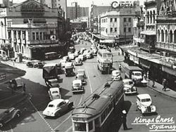
Kings Cross, New South Wales
Kings Cross is an inner-city locality of Sydney, New South Wales, Australia. It is located approximately 2 kilometres east of the Sydney central business district, in the local government area of the City of Sydney...
, before heading into Bayswater Road
Bayswater Road, Sydney
Bayswater Road is a major street in the Kings Cross district of Sydney, New South Wales, Australia.The street is lined with nightspots, eateries, adult venues, dance clubs hotels, and is a popular destination for both Sydneysiders and tourists...
. The line then ran east along Bayswater Road, then into New South Head Road
New South Head Road, Sydney
New South Head Road, is a major road in the Eastern Suburbs of Sydney, Australia. The road runs north-east from Rushcutters Bay through Edgecliff, Double Bay, Point Piper, Rose Bay and Vaucluse where it finally merges into Old South Head Road.-Maroo Track:...
at Rushcutters Bay
Rushcutters Bay, New South Wales
Rushcutters Bay is a harbourside eastern suburb of Sydney, in the state of New South Wales, Australia. Rushcutters Bay is located 3 kilometres east of the Sydney central business district, in the local government area of the City of Sydney....
.
The depot serving the line was at this point, on the north side of the road. The line then followed the course of New South Head Road through Double Bay
Double Bay, New South Wales
Double Bay is a harbourside eastern suburb of Sydney, in the state of New South Wales, Australia. Double Bay is located 4 kilometres east of the Sydney central business district and is the administrative centre of the local government area of the Municipality of Woollahra.Double Bay takes its name...
, Rose Bay
Rose Bay, New South Wales
Rose Bay is a harbourside, eastern suburb of Sydney, in the state of New South Wales, Australia. Rose Bay is located 7 kilometres east of the Sydney central business district, in the local government areas of Waverley Municipal Council and Woollahra Council .Rose Bay has views of both the Sydney...
and Vaucluse
Vaucluse, New South Wales
Vaucluse is an eastern suburb of Sydney, in the state of New South Wales, Australia. Vaucluse is located north-east of the Sydney central business district, in the local government areas of Waverley Council and the Municipality of Woollahra....
. A single track then passed through narrow rock cuttings, low cliffs and rugged back-drops, twisting and turning its way down to the terminus at Watson's Bay
Watsons Bay, New South Wales
Watsons Bay is a harbourside, eastern suburb of Sydney, in the state of New South Wales, Australia. Watsons Bay is located 11 km north-east of the Sydney central business district, in the local government area of the Municipality of Woollahra....
. The line reached Edgecliff in 1894, and Watson's Bay in 1909. In 1949 the line from Rose Bay to Watson's Bay closed, but reopened in 1950 due to public protest. In 1950, the line down King Street to Erskine Street closed and a new terminus constructed at Queens Square. The remainder of the line closed in 1960. This line had its own depot and city terminus and operated independently, although was connected to the main system. The tram line followed the present-day route of buses 324 and L24.
Woolloomooloo Line
This line branched off from Park StreetPark Street, Sydney
Park Street in Sydney, New South Wales, Australia is a major cross street in the centre of the Central Business District. It runs from George Street in the west to College Street in the east, where it becomes William Street.-Description:...
and ran north along Haig Avenue, St John Young Crescent and Lincoln Crescent to Brown's Wharf at Woolloomooloo
Woolloomooloo, New South Wales
Woolloomooloo is a harbourside, inner-city eastern suburb of Sydney, in the state of New South Wales, Australia. Woolloomooloo is located 1.5 kilometres east of the Sydney central business district, in the local government area of the City of Sydney. The suburb is located in a low-lying, former...
. Through service ran from Circular Quay via Elizabeth and Park
Park Street, Sydney
Park Street in Sydney, New South Wales, Australia is a major cross street in the centre of the Central Business District. It runs from George Street in the west to College Street in the east, where it becomes William Street.-Description:...
Streets. The line opened in stages between 1915 and 1918. The line was an early closure, in 1935, being replaced by a bus service from Pyrmont
Pyrmont, New South Wales
Pyrmont is an inner-city suburb of Sydney, in the state of New South Wales, Australia. Pyrmont is located 2 kilometres south-west of the Sydney central business district in the local government area of the City of Sydney...
.
North Bondi via Bondi Junction Line
Services operated from either Circular Quay (via Bridge and Elizabeth Streets) or Railway Square (via Elizabeth and Liverpool Streets), to Oxford StreetOxford Street, Sydney
Oxford Street is a major thoroughfare in Sydney, Australia running from Whitlam Square on the south-east corner of Hyde Park in the central business district of Sydney to Bondi Junction in the Eastern Suburbs. Close to the CBD in particular, the street is lined with numerous shops, bars and...
. The line then passed down Oxford Street to Bondi Junction
Bondi Junction, New South Wales
Bondi Junction is an eastern suburb of Sydney, in the state of New South Wales, Australia. Bondi Junction is located 6 kilometres east of the Sydney central business district and is part of the local government area of the Waverley....
, were it branched off from Bronte services, to run down Bondi Road to Fletcher Street, Campbell Parade and then to the North Bondi
North Bondi, New South Wales
North Bondi is a coastal, eastern suburb of Sydney, in the state of New South Wales, Australia. North Bondi is located 7 kilometres east of the Sydney central business district, in the local government area of Waverley Council....
tram terminus. A feature of this line was the large 3 track terminus cut into a hillside at North Bondi, which opened in 1946. The line opened in 1884 as a steam tramway to Bondi, then to Bondi Beach in 1894. Electric services commenced in 1902. The line closed in 1960. The tram line followed the current route of bus 380 as far as North Bondi.
North Bondi via Paddington and Bellevue Hill Line
Heading south down Elizabeth Street from Circular Quay, the line turned left into Park StreetPark Street, Sydney
Park Street in Sydney, New South Wales, Australia is a major cross street in the centre of the Central Business District. It runs from George Street in the west to College Street in the east, where it becomes William Street.-Description:...
, then wound through East Sydney
East Sydney, New South Wales
East Sydney is a small inner-city locality in Sydney, New South Wales, Australia. It is situated immediately east of the Sydney central business district, adjacent to Hyde Park....
via a right turn into Yurong Street, a left turn into Stanley Street, a right turn into Bourke Street, then a left turn into Burton Street. A feature was the tram only viaduct over Barcom Avenue and Boundary Street in Darlinghurst
Darlinghurst, New South Wales
Darlinghurst is an inner-city, eastern suburb of Sydney, in the state of New South Wales, Australia. Darlinghurst is located immediately east of the Sydney central business district and Hyde Park, within the local government area of the City of Sydney...
as the line headed into MacDonald Street. This viaduct is now a road bridge. The line then twisted down Glenmore, Gurner and Hargreave Streets in Paddington
Paddington, New South Wales
Paddington is an inner-city, eastern suburb of Sydney, in the state of New South Wales, Australia. Paddington is located 3 kilometres east of the Sydney central business district and lies across the local government areas of the City of Sydney and the Municipality of Woollahra...
, then Moncur and Queen Streets in Woollahra. Here, a connection to Oxford Street
Oxford Street, Sydney
Oxford Street is a major thoroughfare in Sydney, Australia running from Whitlam Square on the south-east corner of Hyde Park in the central business district of Sydney to Bondi Junction in the Eastern Suburbs. Close to the CBD in particular, the street is lined with numerous shops, bars and...
allowed access to the Waverley Depot. The line then travelled down Edgecliff and Victoria Roads, then wound along Birriga Road in Bellevue Hill
Bellevue Hill, New South Wales
Bellevue Hill is an eastern suburb of Sydney, in the state of New South Wales, Australia. Bellevue Hill is an affluent suburb, located 5 kilometres east of the Sydney central business district, in the local government area of the Municipality of Woollahra....
, finally running down Curlewis Street in Bondi to join the Bondi Beach via Bondi Junction line on Campbell Parade, to the North Bondi terminus. The line was double track throughout with numerous points to allow short working. Services operated from Circular Quay via Elizabeth Street and Park Street. The line opened to Bellevue Hill in 1909, and to Bondi Beach in 1914. The line was cut back to Ocean Street, Woollahra in 1955; the remainder closed on 27 June 1959. The line followed approximately the current route of bus 389 between the city and Woollahra and route X84 between Woollahra and Bondi Beach.
Bronte Line
This line branched from the North Bondi via Bondi Junction line at Bondi Junction, running down Bronte Road and MacPherson Street to BronteBronte, New South Wales
Bronte is a beachside suburb of Sydney, in the state of New South Wales, Australia. Bronte is located 8 kilometres east of the Sydney central business district, in the Waverley Council local government area of the Eastern Suburbs....
Beach. A feature of this line was the final approach to Bronte Beach in a rock cutting parallel to the Pacific Ocean. The line opened to Waverley in 1890, then to Bronte in 1911. Electric services started to Waverley in 1902, then Bronte in 1911. Through services ran from Circular Quay or Railway Square. The line was closed in 1960 and replaced by a bus service that follows the current route of bus 378.
Clovelly Line
This line branched from Anzac ParadeAnzac Parade, Sydney
Anzac Parade is a major road in the south-eastern suburbs of Sydney, New South Wales, Australia. It included part of the marathon during the 2000 Summer Olympics, and the blue line denoting the marathon's path still exists today.-Description:...
at Alison Road, and ran on its own tram reservation beside Centennial Park
Centennial Park, New South Wales
Centennial Park is a large public, urban park that occupies 220 hectares in the Eastern Suburbs of Sydney in the state of New South Wales, Australia. Centennial Park is located 4 kilometres south-east of the Sydney central business district, in the City of Randwick...
as far as Darley Road. Here it diverged from services to Coogee, to run north along Darley Road, then turned right into Clovelly Road to run down to its terminus at Clovelly Beach. The line opened from Alison Road to the intersection of Clovelly and Carrington Roads in 1912, then to Clovelly
Clovelly, New South Wales
Clovelly is a small beach-side suburb in Sydney's eastern suburbs, in the state of New South Wales, Australia. Clovelly is located 8 kilometres south-east of the Sydney central business district, in the local government area of the City of Randwick, within the Federal Division of Wentworth.Clovelly...
in 1913. Though services ran from Circular Quay and from Railway Square (from 1923). The line closed in 1957. The tram line followed the current route of bus 339.
Coogee Line
The line branched from the line to Clovelly at Darley Road in RandwickRandwick, New South Wales
Randwick is a suburb in south-eastern Sydney, in the state of New South Wales, Australia. Randwick is located 6 kilometres south-east of the Sydney central business district and is the administrative centre for the local government area of the City of Randwick...
. It ran down King Street beside the Randwick Tram Workshops, then ran in its own reservation to Belmore Road. It then ran down Perouse Road, St Pauls Street, Carr Street and Arden Street before terminating in a balloon loop in Dolphin Street, Coogee
Coogee, New South Wales
Coogee is a beachside suburb of local government area City of Randwick. It is located 8 kilometres south-east of the Sydney central business district, in the state of New South Wales, Australia. It is also a part of the Eastern Suburbs of Sydney....
Beach. It ran through several small tram reservations on its way down from Randwick to the beach. The line from Randwick to Coogee opened in 1883, and electric services were introduced in 1902. The line closed in 1960. It follows the current route of bus 373.
La Perouse Line
Darlinghurst, New South Wales
Darlinghurst is an inner-city, eastern suburb of Sydney, in the state of New South Wales, Australia. Darlinghurst is located immediately east of the Sydney central business district and Hyde Park, within the local government area of the City of Sydney...
to run south along Flinders Street, then into its own tram reservation along the eastern side of Anzac Parade
Anzac Parade, Sydney
Anzac Parade is a major road in the south-eastern suburbs of Sydney, New South Wales, Australia. It included part of the marathon during the 2000 Summer Olympics, and the blue line denoting the marathon's path still exists today.-Description:...
beside Moore Park
Moore Park, New South Wales
Moore Park is a large area of parkland in the Eastern Suburbs of Sydney, in the state of New South Wales, Australia. It is part of Centennial Parklands, a collective of three parks being Moore Park, Centennial Park and Queens Park. Centennial Parklands is administered by the Centennial Park &...
. It then proceeded down the centre of Anzac Parade through Maroubra Junction, and Malabar
Malabar, New South Wales
Malabar is a suburb in south-eastern Sydney, in the state of New South Wales, Australia. Malabar is located 12 kilometres south-east of the Sydney central business district, in the local government area of the City of Randwick.-Location:...
to its balloon loop terminus at La Perouse
La Perouse, New South Wales
Lapérouse is a suburb in south-eastern Sydney, in the state of New South Wales, Australia. The suburb of Lapérouse is located about 14 kilometres south-east of the Sydney central business district, in the City of Randwick....
. At Malabar a single line branched off to serve Long Bay Gaol
Long Bay Correctional Centre
Long Bay Correctional Complex is located in the suburb of Malabar in Sydney, New South Wales, Australia. Long Bay comprises six institutions, four maximum security and two minimum security.-History:...
. The line was double track throughout. In 1934 the fourth section of the La Perouse tramline was built to Bunnerong Power Station in Matraville to encourage residential and industrial growth in the area.
The line reached La Perouse in stages from 1900 to 1902. It was the final line to close in 1961. The line followed the current route of bus 394.
Maroubra Line
This line branched off the line to La Perouse at the intersection of Anzac ParadeAnzac Parade, Sydney
Anzac Parade is a major road in the south-eastern suburbs of Sydney, New South Wales, Australia. It included part of the marathon during the 2000 Summer Olympics, and the blue line denoting the marathon's path still exists today.-Description:...
and Maroubra Road, travelling east along Maroubra Road, Cooper Street (now Mons Avenue), French Street and Mons Avenue before terminating in a balloon loop in Marine Parade, Maroubra Bay
Maroubra, New South Wales
Maroubra is a beachside suburb in the Eastern Suburbs of Sydney, in the state of New South Wales, Australia. Maroubra is located 10 kilometres south-east of the Sydney central business district in the local government area of the City of Randwick. Maroubra is the largest suburb in the area governed...
Beach. The line was double track throughout, and passed though several tram reservations on its descent down to the beach. Direct services operated from Circular Quay and Railway Square. The line opened from Anzac Parade to Maroubra Bay in 1921, and closed in 1961. The line followed the current route of bus 397.
Cross Country Line (Bondi Junction - Coogee)
This line branched off Bronte Road at Waverley and travelled south down Albion Street and Frenchmans Road, then via Frances and Cook Streets to join the Coogee line at Belmore Road in Randwick. The line was single track throughout, with a passing loop on Frenchmans Road. Initially services ran from the junction at Albion Street in Wavelery to Randwick only, this was later extended to Coogee in 1907. From 1910, through services operated from Bondi Beach to Coogee Beach, and later additionally from Waverley Depot to Coogee beach. The line opened as a steam tramway in 1887, and was electrified in 1902. It closed in 1954, replaced by the 314 bus.West Kensington via Surry Hills Line
This line branched from the tramlines in Oxford Street and ran down Crown Street to Cleveland Street in Surry HillsSurry Hills, New South Wales
Surry Hills is an inner-city suburb of Sydney, in the state of New South Wales, Australia. Surry Hills is located immediately south-east of the Sydney central business district in the local government area of the City of Sydney...
, then south along Baptist Street to Phillip Street, where it swung left into Crescent Street before running south along Dowling Street. It passed the Dowling Street Depot, then tuned left into Todman Avenue where it terminated at West Kensington
Kensington, New South Wales
Kensington is a suburb in south-eastern Sydney, in the state of New South Wales, Australia. Kensington is located 6 kilometres south-east of the Sydney central business district, in the local government area of the City of Randwick, in the Eastern Suburbs region...
. Services operated fulltime from Circular Quay, and to Railway in peak hours. The line opened in 1881 down Crown Street as far as Cleveland Street as a steam tramway. It was extended to Phillip Street in 1909, Todman Avenue in 1912, and then to its final terminus down Todman Avenue in 1937. The line down Crown Street closed in 1957, the remainder stayed open until 1961 to allow access to the Dowling Street Depot. Sydney Buses routes 301, 302 and 303 generally follow the route down Crown and Baptist Streets as far as Phillip Street.
Botany via Railway Square Line
Route: Services operated from Circular Quay initially via Elizabeth, Chalmers and Redfern Streets (from 1902), then in 1933 via Pitt and Castlereagh Streets, and Eddy Avenue, Lee and Regent Streets, to Botany Street in Waterloo. A single-track connection along Bourke and O'Dea Streets joined at the present day Green SquareGreen Square, New South Wales
Green Square is a district in the inner-city of Sydney in the suburbs of Alexandria, Zetland, Waterloo and Beaconsfield. It is located 4 km south of the Sydney central business district and is part of the local government area of the City of Sydney....
, allowing access to the Dowling Street Depot. The line then passed down the entire length of Botany Road to Botany
Botany, New South Wales
Botany is a suburb in south-eastern Sydney, in the state of New South Wales, Australia. Botany is located 10 kilometres south of the Sydney central business district and is part of the City of Botany Bay....
. In Mascot
Mascot, New South Wales
Mascot is a suburb in south-eastern Sydney, in the state of New South Wales, Australia. Mascot is located 7 kilometres south of the Sydney central business district and is the administrative centre of the City of Botany Bay...
, a branch led to the former Ascot Racecourse at the site of Sydney Airport
Sydney Airport
Sydney Airport may refer to:* Sydney Airport, also known as Kingsford Smith International Airport, in Sydney, Australia* Sydney/J.A. Douglas McCurdy Airport, in Nova Scotia, Canada...
. Points were provided at Bay Street on Botany Road in Botany
Botany, New South Wales
Botany is a suburb in south-eastern Sydney, in the state of New South Wales, Australia. Botany is located 10 kilometres south of the Sydney central business district and is part of the City of Botany Bay....
for short working. The line was double track throughout. From Botany
Botany, New South Wales
Botany is a suburb in south-eastern Sydney, in the state of New South Wales, Australia. Botany is located 10 kilometres south of the Sydney central business district and is part of the City of Botany Bay....
, a single-track line crossed the Botany Goods railway at Beauchamp Road, then passed along Perry Street and Bunnerong Road, past the former Bunnerong Power Station
Bunnerong Power Station, New South Wales
Bunnerong Power Station is a demolished former coal-powered electric power station in the south-eastern Sydney suburb of Matraville, New South Wales, Australia. When the last generating units were commissioned, it was the largest power station in New South Wales, with a capacity of 375 MW. It was...
to join the La Perouse line at Yarra Junction. Generally a shuttle service operated on this single track section between Botany
Botany, New South Wales
Botany is a suburb in south-eastern Sydney, in the state of New South Wales, Australia. Botany is located 10 kilometres south of the Sydney central business district and is part of the City of Botany Bay....
and La Perouse. This single-track line was cut back to Military Road in 1935. The line opened in 1882 as a steam tramway to Botany
Botany, New South Wales
Botany is a suburb in south-eastern Sydney, in the state of New South Wales, Australia. Botany is located 10 kilometres south of the Sydney central business district and is part of the City of Botany Bay....
, and electric services commenced in 1903. The line from the junctions at Cleveland Street to Botany
Botany, New South Wales
Botany is a suburb in south-eastern Sydney, in the state of New South Wales, Australia. Botany is located 10 kilometres south of the Sydney central business district and is part of the City of Botany Bay....
closed in 1960. Sydney Buses route 309 generally follows the route.
Alexandria Line
This line branched from the Botany line at the junction of Henderson and Botany Roads in AlexandriaAlexandria, New South Wales
Alexandria is an inner-city suburb of Sydney, New South Wales, Australia. Alexandria is located 4 kilometres south of the Sydney central business district and is part of the local government area of the City of Sydney...
. The line proceeded down Erskineville Oval) for short working. The line turned right into the present day Sydney Park Road (then known as an extension of Mitchell Road) before terminating at the junction with the Cook's River line at the Princes Highway
Princes Highway
The Princes Highway extends from Sydney to Port Augusta via the coast through the states of New South Wales, Victoria and South Australia, a distance of 1941 km or 1898 km via the former alignments of the highway ....
near St Peters railway station. Services operated from Circular Quay in a route similar to the Botany line as far as the Henderson Road junction. The line opened in 1902 as a single-track electric line, duplicated in 1910. It was closed in 1959. Sydney Buses route 308 generally follows the route as far as St Peters station.
Henderson Road (Erskineville) Line
This short line branched from the Alexandria line tracks at the corner of Henderson and Mitchell Roads in Alexandria and passed along Henderson Road to Park Street in Erskineville, and later to Bridge Street adjacent to Erskineville railway station. Services operated from Circular Quay. The line was an electrified single track throughout. The line opened to Park Street in 1906 and to Bridge Street in 1909. The line was an early closure, in 1933. It was replaced by a private bus service that no longer operates.Rosebery Line
This line opened in 1902 initially via Chalmers and Redfern Streets and south along Elizabeth Street to ZetlandZetland, New South Wales
Zetland is an inner-city suburb of Sydney, New South Wales, Australia. Zetland is located 4 kilometres south of the Sydney central business district, in the local government area of the City of Sydney....
via Elizabeth Street. In 1924, the line was extended to Epsom Road in Rosebery
Rosebery, New South Wales
Rosebery is a suburb in south-eastern Sydney, in the state of New South Wales, Australia. Rosebery is located 6 kilometres south of the Sydney central business district and is part of the local government area of the City of Sydney....
. In 1948, to facilitate construction of the Eastern Suburbs Railway, a new line was constructed down Elizabeth Street between Devonshire Street and Redfern Street and the route was deviated to run down this new section. The line was electrified double track throughout. The line was closed in 1957.
Daceyville Line
This line branched from the Botany Road line at Gardners Road, and passed east along Gardners Road to join the lines at Anzac ParadeAnzac Parade, Sydney
Anzac Parade is a major road in the south-eastern suburbs of Sydney, New South Wales, Australia. It included part of the marathon during the 2000 Summer Olympics, and the blue line denoting the marathon's path still exists today.-Description:...
at what was known as Daceyville
Daceyville, New South Wales
Daceyville is a suburb in south-eastern Sydney, in the state of New South Wales, Australia. Daceyville is located 7 km southeast of the Sydney central business district and is part of the City of Botany Bay....
Junction. It included a large collection of sidings at the former Rosebery Racecourse, now the site of The Lakes Golf Course. The full line opened in 1913, with services from Circular Quay via Waterloo. Some services were extended to Maroubra Beach via the Anzac Pde
Anzac Parade, Sydney
Anzac Parade is a major road in the south-eastern suburbs of Sydney, New South Wales, Australia. It included part of the marathon during the 2000 Summer Olympics, and the blue line denoting the marathon's path still exists today.-Description:...
lines. The line closed in 1957.
Western Lines
The majority of services operated from Fort Macquarie and Circular Quay down George Street to various destinations. In the peak hours and other busy periods, supplementary services operated from Railway Square. The 1920s were seen as a boom period. with up to 200 trams in use on lines to Leichhardt, Drummoyne, Ryde, Abbotsford, Glebe and Balmain on a daily basis. The tram lines to Glebe Point, Balmain (Gladstone Park), Lilyfield, Leichhardt and Haberfield were closed in November 1958.Leichhardt, Abbotsford and Five Dock
Trams also serviced Leichhardt via Parramatta Road and Norton Street, turning right onto Perry Street and then onto Balmain Road where it joined Darling Street. The terminus was located adjacent to the Rozelle Primray School. It was possible to change trams and connect with ferry services at the Darling Street Wharf.The Abbotsford line branched off the Leichhardt line at Marion Street, Leichhardt. The line followed Marion Street, Ramsey Street, Haberfield, and then turned right onto Great North Road, travelling through Five Dock and Abbotsford before terminating near The Terrace and connecting with ferry services at Abbotsford Wharf. The line was closed between Fivedock and Abbotsford in 1954, Haberfield and Five Dock in 1956, and closed to Haberfield
Haberfield, New South Wales
Haberfield is a suburb in the inner-west of Sydney, in the state of New South Wales, Australia. Haberfield is located 9 kilometres west of the Sydney central business district in the local government area of the Municipality of Ashfield....
in 1958.
Lilyfield
The Lilyfield line branched off the Balmain line at Epping Junction (adjacent to Harold Park Raceway and the Rozelle Tram Depot) and then went via reserved trackReserved track
In tram transport terminology reserved track is track on ground exclusively for trams. Unlike track on streets and roads, reserved track does not need to take into account the transit of other wheeled vehicles, pedestrians, bicyclists or horses...
to Taylor Street and then right into Booth Street, Annandale. The tram line turned right into Catherine Street and terminated at the intersection of Abattoir Road and Grove Street, on the bridge over the railway Goods Yard. This was the only tram terminus in Sydney located on a bridge. The Lilyfield line was closed in November 1958.
Balmain
The first steam tram to service Darling Street was in 1892. Ten years later the service was electrified. A feature of this line was a counterweight dummy system that controlled and assisted trams on a steep single-line section of track near the terminus at Darling Wharf. Due to the very steep incline at the bottom of the street, the trams used a complex 'dummy' counterweight system constructed under the road surface. The trams were pushed up the steep hill by the dummy, and rode the dummy on the way down to safely descend the hill.Birchgrove
Services branched off from the main line on Darling Street, turning left into Rowntree Street, then another left into Cameron Street, before turning right into Grove Street and terminating at Wharf Road, Birchgrove.Glebe
This line travelling from the city branched off onto Glebe Point Road from Parramatta Road, terminating near the corner of Pendrill Street.Drummoyne and Ryde
From either Railway Square or Circular Quay services ran along Broadway and Parramatta RoadParramatta Road
.Parramatta Road is the major historical east-west artery of metropolitan Sydney, Australia, connecting the Sydney with Parramatta. It is the eastern-most part of the Great Western Highway. Much of its traffic has been diverted to modern expressways such as the M4 and the City West Link...
. At Forest Lodge the line swung left into Ross Street before entering onto its own reserved track
Reserved track
In tram transport terminology reserved track is track on ground exclusively for trams. Unlike track on streets and roads, reserved track does not need to take into account the transit of other wheeled vehicles, pedestrians, bicyclists or horses...
, now known as Minogue Crescent, passing Rozelle Tram Depot
Rozelle Tram Depot
The former Rozelle tram depot, located in Glebe, New South Wales, is the largest remaining tram depot in Sydney, and is one of five remaining tram depots in the state of New South Wales. It was the second largest tram depot to service the Sydney network, running at peak capacity of approximately...
. Turning right onto Commercial Road (now City West Link Road) and left onto Victoria Road, the tram then crossed the Iron Cove Bridge and the former Gladsville Bridge before turning right onto Blaxland Road. It then wound its way along Blaxland Road, behind the sight of the current council chambers, terminating near the intersection of Pope and Devlin Street in Ryde.
Balmain via Pyrmont
Services commenced at Railway Square, travelling southwest on Broadway, turning right onto Harris Street, passing the former Darling Harbour Goods Yard. At Pyrmont a separate line branched off from the main line on Harris Street, turning left into Miller Street, turning right into Bank Street, crossing the former Glebe Island Bridge. It then travelled along Commercial Road turning right onto Victoria Road, then right onto Darling Street, terminating at the Darling Street Wharf.Forest Lodge
Lines ran along Parramatta Road, Ross Street, St Johns Road, Mt Vernon Street and Catherine Street, as well as Taylor Street.South-Western Lines
Newtown, New South Wales
Newtown, a suburb of Sydney's inner west is located approximately four kilometres south-west of the Sydney central business district, straddling the local government areas of the City of Sydney and Marrickville Council in the state of New South Wales, Australia....
. Four lines then proceeded to Cooks River
Cooks River
The Cooks River is a 23 kilometre long urban waterway of south-western Sydney, New South Wales, Australia emptying into Botany Bay. The course of the river has been altered to accommodate various developments along its shore...
, Dulwich Hill
Dulwich Hill, New South Wales
Dulwich Hill is a residential suburb in the Inner West of Sydney, in the state of New South Wales, Australia. Dulwich Hill is located 9 kilometres south-west of the Sydney central business district, in the local government area of Marrickville Council...
, Canterbury
Canterbury, New South Wales
-Commercial area:Canterbury has a mixture of residential, commercial and industrial developments. Commercial developments are mostly situated on Canterbury Road and surrounding streets...
and Earlwood
Earlwood, New South Wales
Earlwood is a suburb in the inner-west of Sydney, in the state of New South Wales, Australia. Earlwood is located 12 kilometres south of the Sydney central business district, in the local government area of the City of Canterbury...
. A short lived line also operated between Canterbury and Summer Hill.
Cooks River Line
This line ran south-west along City Road from BroadwayBroadway, New South Wales
Broadway is a road in Sydney, in the state of New South Wales, Australia. The road constitutes the border between the suburbs of Ultimo and Chippendale . Broadway is also an urban locality....
, then along King Street in Newtown
Newtown, New South Wales
Newtown, a suburb of Sydney's inner west is located approximately four kilometres south-west of the Sydney central business district, straddling the local government areas of the City of Sydney and Marrickville Council in the state of New South Wales, Australia....
past Newtown
Newtown railway station, Sydney
-Transport links:Sydney Buses runs nine routes via Newtown station:*Route 352 - weekdays daytime services - between Bondi Junction Interchange and Marrickville Metro Shopping Centre...
and St Peters railway stations to the Princes Highway. It then proceeded down the Princes Highway to its terminus at the Cooks River
Cooks River
The Cooks River is a 23 kilometre long urban waterway of south-western Sydney, New South Wales, Australia emptying into Botany Bay. The course of the river has been altered to accommodate various developments along its shore...
. At Tempe
Tempe, New South Wales
Tempe is a suburb in the inner west of Sydney, in the state of New South Wales, Australia. Tempe is located 9 kilometres south of the Sydney central business district in the local government area of Marrickville Council....
, a connection lead to the Tempe Depot. Past the terminus at the Cooks River
Cooks River
The Cooks River is a 23 kilometre long urban waterway of south-western Sydney, New South Wales, Australia emptying into Botany Bay. The course of the river has been altered to accommodate various developments along its shore...
, a single line led over the river to the Wolli Creek Perway Yard. The line reached St Peters as a steam tramway in 1891, then to Cooks River
Cooks River
The Cooks River is a 23 kilometre long urban waterway of south-western Sydney, New South Wales, Australia emptying into Botany Bay. The course of the river has been altered to accommodate various developments along its shore...
in 1900 when electric services commenced. The line closed in 1957, and bus 422 parallels the former line.
Dulwich Hill Line
This line branched from the line to Cooks River at Newtown, and travelled down Enmore Road through Enmore, then along Victoria Road to Marrickville Road before tuning right along Marrickville Road through MarrickvilleMarrickville, New South Wales
Marrickville, a suburb of Sydney's Inner West is located 7 kilometres south-west of the Sydney central business district in the state of New South Wales, Australia and is the largest suburb in the Marrickville Council local government area...
and Dulwich Hill
Dulwich Hill, New South Wales
Dulwich Hill is a residential suburb in the Inner West of Sydney, in the state of New South Wales, Australia. Dulwich Hill is located 9 kilometres south-west of the Sydney central business district, in the local government area of Marrickville Council...
to Canterbury Road. At the Canterbury Road terminus, a tram tuning loop was provided, this is currently used as a layover area for buses. Current bus route 426 follows this tramline.
Canterbury Line - Darling Street Wharf
A cross country connection between the Canterbury Line at New Canterbury Road to Petersham and the Western Suburbs lines on Parramatta Road allowed a cross country service to operate between Canterbury and Balmain. From Crystal Street, Fort Street (single line loops), Parramatta Road, this route continued via Norton Street Leichhardt to Balmain Road Rozelle where it crossed Victoria Road, then Darling Street Wharf, East Balmain, to reach the wharf itself with the help of the famous counterweight. It is now and has been the 445 Bus Route since trams stopped running in 1957.From Circular Quay trams reached Newtown via Catlereagh Street (Pitt Street to the Quay) Broadway, City Road, King Street, then headed south on Enmore Road the tram turned right into Addison Road, before turning right into Livingstone Road and then left onto New Canterbury Road in Petersham
Petersham, New South Wales
Petersham is a suburb in the Inner West of Sydney, in the state of New South Wales, Australia. Petersham is located 6 kilometres south-west of the Sydney central business district, in the local government area of Marrickville Council...
. The line then travelled down New Canterbury Road through Dulwich Hill and Hurlstone Park
Hurlstone Park, New South Wales
Hurlstone Park is a suburb in the inner-west of Sydney, in the state of New South Wales, Australia. Hurlstone Park is located 10 kilometres south-west of the Sydney central business district and is mostly in the local government area of the City of Canterbury, and partly in the Municipality of...
to a terminus adjacent to Canterbury railway station
Canterbury railway station, Sydney
-Accessibility:The station has street access to both platforms via stairs. This does not allow for Easy Access for wheelchairs.-Transport links:Sydney Buses runs six routes via Canterbury station:...
in Broughton Street. Current bus route 444 follows the route of this line. From the time trams ceased running at Canterbury and for a long while this was bus route 448.
Earlwood Line
This line branched from the line to Dulwich Hill at Illawarra Road at Marrickville Road. It travelled south-west along Illawarra Road, crossing the Cooks River, followed by a steep ascent up Homer Street to the Earlwood shopping district. The line terminated in Homer Street at the intersection of William Street and Hartill Law Avenue.Current bus route 423 follows the former tram line, although this bus route now extends to Kingsgrove.
Cooks River- Dulwich Hill Line
A cross country line connected the Cooks River Line and the Dulwich Hill line via Sydenham, operating along Railway Road and Sydenham Road in SydenhamSydenham, New South Wales
For other places called Sydenham, see Sydenham .Sydenham is a small suburb in the inner-west of Sydney, in the state of New South Wales, Australia. Sydenham is located 8 kilometres south of Sydney central business district and is part of the local government area of Marrickville Council...
. A cross country service operated between Cooks River and Dulwich Hill.
Hurlstone Park- Summer Hill Line
A short lived single track line operated from the Canterbury Line at Hurlstone Park along Old Canterbury Road and Prospect Road to Summer Hill railway station. Services operated between Canterbury and Summer Hill from 1915 however low patronage and competition from motor buses saw the line close in 1933. The disused track and overhead remained in place until the 1950s.Erskineville Line
This line branched from tracks at Regent Street in ChippendaleChippendale, New South Wales
Chippendale is a small inner-city suburb of Sydney, New South Wales, Australia. Chippendale is located on the southern edge of the Sydney central business district, in the local government area of the City of Sydney...
, and passed west along Meagher Street, then south into Abercombie Street. It followed Abercrombie St south across the junction with Cleveland Street through Golden Grove, before swinging south into Golden Grove St then right into Wilson Street. The line then passed under the railway lines at Burren Street, adjacent to the entrance to Macdonaldtown railway station. The line then became a single track loop passing up Burren Street to Erskineville
Erskineville, New South Wales
Erskineville is an inner-city suburb of Sydney, in the state of New South Wales, Australia. Erskineville is located about 3 kilometres south of the Sydney central business district and is part of the local government area of the City of Sydney...
Road, then west along Erskineville Road to Septimus Street, then Albert Street before rejoining the tracks at Burren Street. Services operated from Circular Quay using the Pitt and Castlereagh Streets lines. The line opened as an electric double track tramway in 1909. The line south of Cleveland Street closed in 1940, with the northern section used by other services until its closure in 1958.
Rockdale to Brighton-Le-Sands Line
Brighton-Le-Sands, New South Wales
Brighton-Le-Sands , is a suburb in southern Sydney, in the state of New South Wales, Australia. Brighton-Le-Sands is located 13 kilometres south of the Sydney central business district, on the western shore of Botany Bay...
. The line was single track throughout, with a passing loop at each end. The line closed in 1949 and was replaced by a bus service. A small depot in Rockdale maintained the cars.
Kogarah to Sans Souci Line
This steam tramway opened in 1887 using small railway locomotives and carriages. In 1891 two conventional steam tram motors were built for the line by Henry Vale. Six C1 type trailers replaced the railway carriages around the same period. The tramway operated for 50 years until it was replaced by an electric trolleybusTrolleybus
A trolleybus is an electric bus that draws its electricity from overhead wires using spring-loaded trolley poles. Two wires and poles are required to complete the electrical circuit...
service in 1937. It connected with trains at Kogarah station by way of a large balloon loop through the streets, then passed south down Rocky Point Road to Sans Souci
Sans Souci, New South Wales
Sans Souci is a southern Sydney suburb in the state of New South Wales, Australia. Sans Souci is 17 kilometres south of the Sydney central business district and lies across the local government areas of the City of Rockdale and the Municipality of Kogarah. It is part of the St George area.Sans...
, Sandringham
Sandringham, New South Wales
Sandringham is a suburb in southern Sydney, in the state of New South Wales, Australia. Sandringham is located 18 kilometres south of the Sydney central business district and is part of the St George area. Sandringham is in the local government area of the City of Rockdale.Sandringham is a quiet...
and Dolls Point
Dolls Point, New South Wales
Dolls Point is a small suburb in southern Sydney, in the state of New South Wales, Australia. Dolls Point is located 17km south of the Sydney central business district and is part of the St George area. Dolls Point is in the local government area of the City of Rockdale.Dolls Point takes its name...
. Small depots at Sandringham and Kogarah serviced the line. The line was single track at each end with a double-track middle section down Rocky Point Road. Track on the line was laid to railway standards to allow railway trucks to haul goods over the line.
Wilson's 1917 map shows the route leaving Kogarah Station (no loop), then Gray Street, across Kogarah Road, and thence by a ROW to
Rocky Point Road, entering near Herman Street, thence along Russell Avenue, Clareville Street to the foreshore, then along the foreshore
(now Cook Park) to Sans Souci/Rocky Point Road, then north along that road, rejoining the line at Russell Avenue.
Arncliffe to Bexley Line
This steam tramway opened in 1909 and closed in 1926. It connected with trains at Arncliffe station, and ran down Wollongong Road, then Forest Road through Bexley before terminating at the corner of Forest and Preddys Roads, Bexley. The line was single track, with a passing loop midway. A small car shed at ArncliffeArncliffe, New South Wales
Arncliffe is a suburb in southern Sydney, in the state of New South Wales, Australia. Arncliffe is located 11 kilometres south of the Sydney central business district, in the local government area of the City of Rockdale. Arncliffe is part of the St George area.Arncliffe is located south of the...
maintained the trams.
Sutherland to Cronulla Line
This line opened as a steam tramway between Sutherland railway station and Cronulla'sCronulla, New South Wales
Cronulla is a beachside suburb, in southern Sydney, in the state of New South Wales, Australia. Cronulla is located 26 kilometres south of the Sydney central business district, in the local government area of Sutherland Shire....
Shelley Beach, in 1911. It closed to passengers and was replaced by a bus service in 1931, and closed completely in 1932. It pre-dated the Sutherland
Sutherland, New South Wales
Sutherland is a suburb in southern Sydney, in the state of New South Wales, Australia. Sutherland is located 26 kilometres south of the Sydney central business district and is the administrative centre for the local government area of the Sutherland Shire....
to Cronulla branch of the Illawarra line, which took over its role.
North Shore Lines
Wynyard railway station, Sydney
Wynyard is a major underground CityRail station in the central business district of Sydney, Australia, 2.05 km from Central. Wynyard averages 108000 passenger movements per day Monday to Friday.-History:The station opened on 28 February 1932...
(the only one in Australia), and the tracks over the Sydney Harbour Bridge
Sydney Harbour Bridge
The Sydney Harbour Bridge is a steel through arch bridge across Sydney Harbour that carries rail, vehicular, bicycle and pedestrian traffic between the Sydney central business district and the North Shore. The dramatic view of the bridge, the harbour, and the nearby Sydney Opera House is an iconic...
. Trams ran from Blue Street, North Sydney over a now-demolished steel arch bridge over the Harbour Bridge Roadway, then over the eastern side of the harbour bridge (now road lanes), through a tram platform at Milsons Point similar to the existing railway station, and dived underground into platforms 1 and 2 of Wynyard station. These platforms were converted into a car park after the tramway's closure in 1958. Wynyard station's railway platforms are thus numbered 3-6.
The line along Military Road, opened in September, 1893, was the first permanent electric tramway in Sydney and New South Wales.
The first part of the North Sydney tramway system was a double-track cable tramway which started at the original Milsons Point Ferry wharf
Milsons Point, New South Wales
Milsons Point is a suburb on the lower North Shore of Sydney, in the state of New South Wales, Australia. North Sydney is located 3 kilometres north of the Sydney central business district in the local government area of North Sydney Council....
, located where the north pylon of the Harbour Bridge is now. The line originally extended via Alfred Street (now Alfred Street South), Junction Street (now Pacific Highway), Blue Street and Miller Streets to the engine house and depot at Ridge Street. It used cable grip cars called "dummies" and unpowered trailer cars, similar to the large Melbourne cable tramway system but quite different to the surviving lines in San Francisco, where everything is combined in a single vehicle.
The original cable line was extended via Miller and Falcon Streets to Crows Nest, and later the whole line was electrified and extensions were built to various termini around the Lower North Shore.
The history of the North Sydney tramway system can be divided into three periods - the first from the original opening in 1886 to 1909, when the McMahons Point line opened. The second period covers the time until the Wynyard line was opened across the Sydney Harbour Bridge in 1932, and the third from then until the general closure of the system in 1958.
First period 1886 - 1909
In the initial years of the North Sydney tramways, services operated from Milsons Point Ferry wharfMilsons Point, New South Wales
Milsons Point is a suburb on the lower North Shore of Sydney, in the state of New South Wales, Australia. North Sydney is located 3 kilometres north of the Sydney central business district in the local government area of North Sydney Council....
to....
- The site of the current Independent TheatreIndependent TheatreThe Independent Theatre was a dramatic society founded in 1930 by Doris Fitton , and was also the name given to the building it occupied from 1938. It was named for London's Independent Theatre Society founded by J. T...
on Ridge Street, North SydneyNorth Sydney, New South WalesNorth Sydney is a suburb and commercial district on the Lower North Shore of Sydney, in the state of New South Wales, Australia. North Sydney is located 3 kilometres north of the Sydney central business district and is the administrative centre for the local government area of North Sydney...
via the original cable tramway opened in May 1886. Services were extended to Crows Nest in July, 1893, and the whole line was converted to electric operation in February 1900.
- MosmanMosman, New South WalesMosman is a suburb on the Lower North Shore of Sydney, in the state of New South Wales, Australia. Mosman is located 8 kilometres north-east of the Sydney central business district and is the administrative centre for the local government area of the Municipality of Mosman.-Localities:In February...
Ferry Wharf - opened as an electric line from Miller and Ridge streets, along Miller Street, Falcon Street, and then Military Road as far as Spit Junction in September 1893 and extended to Mosman Wharf in March 1897. Services initially connected with the cable trams at Ridge Street and shared the cable tracks as far as Miller and Falcon Streets.
- ChatswoodChatswood, New South WalesChatswood is a suburb on the North Shore of Sydney, in the state of New South Wales, Australia. Chatswood is located 10 kilometres north of the Sydney central business district and is the administrative centre of the local government area of the City of Willoughby. Chatswood West is a separate suburb...
- also opened initially as an electric line from Crows Nest with services connecting with the cable trams at Ridge Street and sharing the cable tracks as far as Crows Nest. It opened as far as Victoria Avenue, WilloughbyWilloughby, New South WalesWilloughby is a suburb on the lower North Shore of Sydney, in the state of New South Wales, Australia. Willoughby is located 8 kilometres north of the Sydney central business district, in the local government area of the City of Willoughby....
in April 1898 and extended to ChatswoodChatswood, New South WalesChatswood is a suburb on the North Shore of Sydney, in the state of New South Wales, Australia. Chatswood is located 10 kilometres north of the Sydney central business district and is the administrative centre of the local government area of the City of Willoughby. Chatswood West is a separate suburb...
Station in July 1908. Through electric services from Milsons Point began when the original cable tramway was electrified in February 1900.
- Lane CoveLane Cove, New South WalesLane Cove is a suburb on the lower North Shore of Sydney, in the state of New South Wales, Australia. An affluent suburb, Lane Cove is located 9 kilometres north-west of the Sydney central business district and is the administrative centre for the local government area of the Municipality of Lane...
- opened as an electric line from Crows Nest in February, 1900, with trams connecting with other electric services at Ridge Street. It was initially opened as far as Gore HillGore Hill, New South WalesGore Hill is an urban locality on the North Shore of Sydney, in the state of New South Wales, Australia. Gore Hill is located in the western part of the suburb of St Leonards....
and extended to Lane CoveLane Cove, New South WalesLane Cove is a suburb on the lower North Shore of Sydney, in the state of New South Wales, Australia. An affluent suburb, Lane Cove is located 9 kilometres north-west of the Sydney central business district and is the administrative centre for the local government area of the Municipality of Lane...
in March 1909. Some through services operated to and from Milsons Point.
- The SpitThe Spit, New South WalesThe Spit is an urban locality in the suburb of Mosman in Sydney, New South Wales, Australia. The Spit is located in the local government area of the Municipality of Mosman and is part of the Lower North Shore.-Landmarks:...
- opened from Spit Junction in October 1900.
- NorthbridgeNorthbridge, New South WalesNorthbridge is a suburb on the lower North Shore of Sydney, New South Wales, Australia. Northbridge is located 7 kilometres north of the Sydney central business district, in the local government area of Willoughby....
- opened from Miller and Falcons Streets as far as Suspension Bridge CammerayCammeray, New South WalesCammeray is a suburb on the lower North Shore of Sydney, New South Wales, Australia. Cammeray is located 5 kilometres north of the Sydney central business district, in the local government area of North Sydney Council.Cammeray is mostly a residential area...
in May 1909, to Marana Road NorthbridgeNorthbridge, New South WalesNorthbridge is a suburb on the lower North Shore of Sydney, New South Wales, Australia. Northbridge is located 7 kilometres north of the Sydney central business district, in the local government area of Willoughby....
in February 1914, and to NorthbridgeNorthbridge, New South WalesNorthbridge is a suburb on the lower North Shore of Sydney, New South Wales, Australia. Northbridge is located 7 kilometres north of the Sydney central business district, in the local government area of Willoughby....
terminus in March 1914
- Georges HeightsGeorges Heights, New South WalesGeorges Heights is an urban locality in the suburb of Mosman, in Sydney, in the state of New South Wales, Australia. Georges Heights is located in the local government area of the Municipality of Mosman and is part of the Lower North Shore.-History:...
- opened from Mosman Junction along Middle Head Road to Cobbittee Street in August 1919, for the military hospital, closed beyond the junction with the Balmoral line at Gordon Street in 1925.
- BalmoralBalmoral, New South WalesBalmoral is an urban locality in the suburb of Mosman in Sydney, New South Wales, Australia. Balmoral is located in the local government area of the Municipality of Mosman and is part of the Lower North Shore....
- opened as a branch of the Georges Heights line in May, 1922
During this first period, some North Sydney tramway services did not operate to and from Milsons Point. These were:
- Ridge Street, North SydneyNorth Sydney, New South WalesNorth Sydney is a suburb and commercial district on the Lower North Shore of Sydney, in the state of New South Wales, Australia. North Sydney is located 3 kilometres north of the Sydney central business district and is the administrative centre for the local government area of North Sydney...
- Taronga ZooTaronga ZooTaronga Zoo is the city zoo of Sydney, New South Wales, Australia. Officially opened on 7 October 1916, it is located on the shores of Sydney Harbour in the suburb of Mosman...
- introduced over the Mosman line and the new Taronga Zoo line opened in conjunction with the relocation of the zoo from Moore Park to Mosman in October 1916.
- Neutral Bay WharfNeutral Bay, New South WalesNeutral Bay is a harbourside suburb on the lower North Shore of Sydney, New South Wales, Australia. Neutral Bay is located 5 kilometres north of the Sydney central business district, in the local government area of North Sydney Council....
- Neutral Bay Junction - opened in June 1900. This line had a combination of long, steep grades and only trams fitted with track brakes (which were not otherwise used on the Sydney tramways) were permitted to operate this line.
- Cremorne WharfCremorne, New South WalesCremorne is a suburb on the lower North Shore of Sydney, New South Wales, Australia. Cremorne is located 6 kilometres north of the Sydney central business district, in the local government area of North Sydney Council....
- the SpitThe Spit, New South WalesThe Spit is an urban locality in the suburb of Mosman in Sydney, New South Wales, Australia. The Spit is located in the local government area of the Municipality of Mosman and is part of the Lower North Shore.-Landmarks:...
- opened December 1911.
- Taronga Park Wharf (now Taronga Zoo Wharf) - BalmoralBalmoral, New South WalesBalmoral is an urban locality in the suburb of Mosman in Sydney, New South Wales, Australia. Balmoral is located in the local government area of the Municipality of Mosman and is part of the Lower North Shore....
- introduced December 1923. the service operated over the Athol Wharf line, opened in October 1917, the Taronga Zoo line, a new connection in King Max Street, Mosman opened in December 1923 and the Georges Heights/Balmoral line.
- Taronga ZooTaronga ZooTaronga Zoo is the city zoo of Sydney, New South Wales, Australia. Officially opened on 7 October 1916, it is located on the shores of Sydney Harbour in the suburb of Mosman...
- Gore HillGore Hill, New South WalesGore Hill is an urban locality on the North Shore of Sydney, in the state of New South Wales, Australia. Gore Hill is located in the western part of the suburb of St Leonards....
and (later) Lane CoveLane Cove, New South WalesLane Cove is a suburb on the lower North Shore of Sydney, in the state of New South Wales, Australia. An affluent suburb, Lane Cove is located 9 kilometres north-west of the Sydney central business district and is the administrative centre for the local government area of the Municipality of Lane...
and to ChatswoodChatswood, New South WalesChatswood is a suburb on the North Shore of Sydney, in the state of New South Wales, Australia. Chatswood is located 10 kilometres north of the Sydney central business district and is the administrative centre of the local government area of the City of Willoughby. Chatswood West is a separate suburb...
- operated via the Taronga Zoo and Mosman lines, Falcon Street to Crows Nest, then as for the services from McMahons Point.
Second period 1909 - 1932
In September 1909, a new line was opened from McMahons Point to Victoria Cross, North Sydney and a new direct route was opened via what is now the Pacific Highway from Victoria Cross to Crows Nest. The Milsons Point line was deviated at North Sydney via Walker and Mount Streets to avoid congestion at Victoria Cross. The McMahons Point line was opened to relieve the load on the Milsons Point ferry wharf and connecting tramway. Services to Lane Cove and Chatswood were altered to operate to and from McMahons Point via the new direct route to Crows Nest. In conjunction with the construction of the Sydney Harbour Bridge, the Milsons Point line was diverted to a new terminus in Glen Street in July 1924. Escalators were provided to carry tram passengers to the new ferry wharf below. Otherwise, services operated as during the first period.Third period 1932 - 1958
In March, 1932 the Sydney Harbour Bridge with its associated railway and tramway tracks was opened and all of the above services to and from Milsons Point/McMahons Point (except the Georges Heights service, which had closed in 1925) were diverted to operate to and from Wynyard. The Milsons Point and McMahons Point lines were then closed.From Wynyard
Wynyard railway station, Sydney
Wynyard is a major underground CityRail station in the central business district of Sydney, Australia, 2.05 km from Central. Wynyard averages 108000 passenger movements per day Monday to Friday.-History:The station opened on 28 February 1932...
services operated to....
- Lane CoveLane Cove, New South WalesLane Cove is a suburb on the lower North Shore of Sydney, in the state of New South Wales, Australia. An affluent suburb, Lane Cove is located 9 kilometres north-west of the Sydney central business district and is the administrative centre for the local government area of the Municipality of Lane...
- Travelling along the Pacific Highway via Gore Hill, turning left into Longueville Road, terminating near the intersection of Rothwell Avenue (now Central Avenue), opposite the council chambers.
- ChatswoodChatswood, New South WalesChatswood is a suburb on the North Shore of Sydney, in the state of New South Wales, Australia. Chatswood is located 10 kilometres north of the Sydney central business district and is the administrative centre of the local government area of the City of Willoughby. Chatswood West is a separate suburb...
- Turning right off either Falcon Street or the Pacific Highway in Crows Nest, heading north along Willoughby Road, turning left onto Mowbray followed by a sharp right onto Penshurst Street before turning left on Victoria Avenue, where the line terminated at Chatswood railway station, providing passengers with a short interchange between train services.
- NorthbridgeNorthbridge, New South WalesNorthbridge is a suburb on the lower North Shore of Sydney, New South Wales, Australia. Northbridge is located 7 kilometres north of the Sydney central business district, in the local government area of Willoughby....
- closed beyond Cammeray in May 1936 and beyond Falcon Street, North Sydney in January 1948
- The SpitThe Spit, New South WalesThe Spit is an urban locality in the suburb of Mosman in Sydney, New South Wales, Australia. The Spit is located in the local government area of the Municipality of Mosman and is part of the Lower North Shore.-Landmarks:...
and Spit Junction line travelled northeast along Military Road passing through Neutral Bay Junction, Cremorne Junction, and Spit Junction, veering to the left (north) onto Spit Road at Spit Junction, before diverting onto Parriwi Road and terminating near the foot of the Spit Bridge.
- BalmoralBalmoral, New South WalesBalmoral is an urban locality in the suburb of Mosman in Sydney, New South Wales, Australia. Balmoral is located in the local government area of the Municipality of Mosman and is part of the Lower North Shore....
- reduced to limited services outside ferry operating hours following the introduction of the co-ordinated tram/ferry scheme in May 1952. This scheme was brought in following the government's purchase of Sydney Ferries Ltd, and was designed to encourage greater use of ferries.
- Taronga ParkTaronga ZooTaronga Zoo is the city zoo of Sydney, New South Wales, Australia. Officially opened on 7 October 1916, it is located on the shores of Sydney Harbour in the suburb of Mosman...
- reduced to limited services outside ferry operating hours as stated in relation to the Wynyard - Balmoral service.
All of these lines remained open until the general closure of the North Sydney tramways in June 1958, except for the Northbridge / Suspension Bridge line, and the withdrawal of full-time services from Wynyard to Balmoral and Taronga Zoo as stated above.
Cross-country services during this period were...
- Neutral Bay WharfNeutral Bay, New South WalesNeutral Bay is a harbourside suburb on the lower North Shore of Sydney, New South Wales, Australia. Neutral Bay is located 5 kilometres north of the Sydney central business district, in the local government area of North Sydney Council....
- Neutral Bay Junction - closed in May 1956. As mentioned above, this line had a combination of long, steep grades and windy track, and only trams fitted with track brakes (which were not otherwise used on the Sydney tramways) or dynamic (rheostatic) brakesDynamic brakingDynamic braking is the use of the electric traction motors of a railroad vehicle as generators when slowing the Locomotive. It is termed rheostatic if the generated electrical power is dissipated as heat in brake grid resistors, and regenerative if the power is returned to the supply line...
were permitted. The single track down Hayes Street was the steepest unassisted in Sydney.
- Cremorne WharfCremorne, New South WalesCremorne is a suburb on the lower North Shore of Sydney, New South Wales, Australia. Cremorne is located 6 kilometres north of the Sydney central business district, in the local government area of North Sydney Council....
- The SpitThe Spit, New South WalesThe Spit is an urban locality in the suburb of Mosman in Sydney, New South Wales, Australia. The Spit is located in the local government area of the Municipality of Mosman and is part of the Lower North Shore.-Landmarks:...
- the Cremorne Wharf line closed in April 1956.
- Mosman WharfMosman, New South WalesMosman is a suburb on the Lower North Shore of Sydney, in the state of New South Wales, Australia. Mosman is located 8 kilometres north-east of the Sydney central business district and is the administrative centre for the local government area of the Municipality of Mosman.-Localities:In February...
- Cremorne Junction. The Mosman Wharf line closed in November 1955.
- Athol Wharf (now Taronga Zoo Wharf) - BalmoralBalmoral, New South WalesBalmoral is an urban locality in the suburb of Mosman in Sydney, New South Wales, Australia. Balmoral is located in the local government area of the Municipality of Mosman and is part of the Lower North Shore....
A feature of this line was the steep grade down to the wharf at the terminus. Runaway trams plunged into the harbour in 1942, 1952 and 1958.
- Taronga ZooTaronga ZooTaronga Zoo is the city zoo of Sydney, New South Wales, Australia. Officially opened on 7 October 1916, it is located on the shores of Sydney Harbour in the suburb of Mosman...
- Lane CoveLane Cove, New South WalesLane Cove is a suburb on the lower North Shore of Sydney, in the state of New South Wales, Australia. An affluent suburb, Lane Cove is located 9 kilometres north-west of the Sydney central business district and is the administrative centre for the local government area of the Municipality of Lane...
and ChatswoodChatswood, New South WalesChatswood is a suburb on the North Shore of Sydney, in the state of New South Wales, Australia. Chatswood is located 10 kilometres north of the Sydney central business district and is the administrative centre of the local government area of the City of Willoughby. Chatswood West is a separate suburb...
- operated via the Taronga Zoo and Military lines, Falcon Street to Crows Nest, then as for the services from Wynyard
Services also operated as follows
- BalmoralBalmoral, New South WalesBalmoral is an urban locality in the suburb of Mosman in Sydney, New South Wales, Australia. Balmoral is located in the local government area of the Municipality of Mosman and is part of the Lower North Shore....
- Lane Cove and Chatswood - The line from Balmoral opened as a branch of the Georges Heights line in May, 1922 and was one of the last tram lines to be opened in Sydney. It was a difficult route to construct on account of the height above sea level and the short distance to be traversed. Apart from the direct city service to Wynyard via the Sydney Harbour Bridge, cross regional services ran to Lane CoveLane Cove, New South WalesLane Cove is a suburb on the lower North Shore of Sydney, in the state of New South Wales, Australia. An affluent suburb, Lane Cove is located 9 kilometres north-west of the Sydney central business district and is the administrative centre for the local government area of the Municipality of Lane...
, Athol Wharf (now Taronga Park Zoo wharf), Northbrdge and Chatswood, making it one of the busiest lines on the North Sydney system.
- Upon departure from the The Esplanade Terminus, at the corner of Mandalong Road, trams travelled south-East along The Esplanade. After passing Botanic Road the line swung right onto Henry Plunkett Reserve. From this point the line went off road and ascended uphill onto its own reservation, travelling through a narrow rock cutting, now public walking track (pictured). After a steep ascent through the reserve the line crossed several small residential streets along the way, such as; Mulbring, Gordon, Plunkett and Beaconsfield Street, before once again entering onto Gordon Street where the line swung right onto Middle Head Road. The tram then joined the main line at the point where Bradleys Head Road, Military Road and Middle Head road meet. Travelling along Military Road and then Falcon Street, services to Chatswood turned right onto Willoughby Road, and eventually terminated at Chatswood railway station, Victoria Street Terminus, while services to Lane Cove travelled along the Pacific Highway, terminating at the Lane Cove council chambers. Services to Wynyard via North Sydney swung left into Miller street before crossing the Pacific Highway and entering onto the on ramp that lead to the overhead steel truss bridge that once crossed over the Sydney Harbour Bridge.
NB "Athol Wharf" above refers to the facility now known as "Taronga Zoo Wharf" and now referred to as such on bus maps and signs.
Manly Lines
The Manly lines originated on 14 February 1903 with steam motors hauling trailers on a line from Manly to Curl Curl (North Manly).Passenger traffic fell considerably by autumn that year, and services reverted to horse-drawn trams from 20 July 1903.
However, following considerable increase in passengers during the next four years, steam trams were returned from 1 October 1907.
A line was built to The Spit, and the Manly to Curl Curl line was progressively extended to Brookvale, Collaroy, and Narrabeen.
A branch was run to Harbord. Electrification commenced with the construction of the line to The Spit,
and was extended throughout the system.
The Narrabeen line was also used for carrying freight, for a spur was run to the freight wharf at Manly,
and goods sidings were built at Balgowlah in Sydney Road near Wonganella Street; at Brookvale from a line in Alfred Road
short of Federal Parade; and at Narrabeen near King Street.
Various track layouts and routes
existed in the early days in the vicinity of the Manly terminus, with quite different arrangements existing in 1903, 1911, 1912, and 1914.
The routes prior to 1914 used the Corso and North Steyne, but from 1914 were confined to Belgrave Street. The Manly lines closed in 1939.
The Manly lines, which were administered by the Railways, suffered from maladministration (as in the case of the Castle Hill line),
resulting in considerable overcapitalisation of the network, unnecessary re-routing and re-building of the track at Manly terminus.
Consequently the system never made a profit.
Re-building the terminal at Manly terminus several times, accompanied by costly property resumption, accounted for huge expenditures with little gain.
In 1919 planning began to move slightly the balloon loop at Manly, requiring demolition and re-building the Pier Hotel.
Rebuilding track in Belgrave street and the terminus was estimated to cost £5,695,
while land resumption including demolition of the Pier Hotel was estimated at £40,000 (less £3,500 from sale of land).
The hotel was demolished in 1924.
The Department was slow to provide a speedy service. It persisted in scheduling the long-distance trams behind the all-stops
(instead of the other way around). It rejected residents' suggestions to schedule the Narrabeen tram first, and to make the first set-down
Dee Why or similar place.
For nearly a decade from at least 1923, residents had been asking for faster services to Narrabeen. The trip took 49 minutes.
A new timetable was introduced from 1 November 1920, giving a trip time of 39 minutes,
but it proved unworkable and the timetable reverted to an old one on 4 July 1921, back to 48 minutes.
Residents wanted optional stopping and express running to Dee Why from Manly. The Railways ignored those requests,
and persisted in running the Narrabeen tram from Manly, behind the all-stops trams to Balgowlah and Harbord.
Finally, when the Department moved to schedule Narrabeen trams first, with first set-down at Dee Why from 25 November 1931, it took only
31–33 minutes by tram from Manly to Narrabeen, down from 39 minutes previously, and down from 49 minutes when the service was inaugurated.
Manly- The Spit
This line commenced at the Spit Bridge (north side) with a balloon loop.From the balloon loop, in a reservation, the line ascended in a ROW beside Sydney Road,
Heaton avenue, crossed Ethel Street, still in a ROW alongside Whittle Street, joining Sydney Road there.
At Parkview street there was a semi-circular deviation south, out of Sydney Road (to gain height for
Spit-bound trams). At Park Avenue a ROW took the tram north, then east alongside Raglan Street,
eventually joining Raglan Street at Kangaroo Road. From there, which was a junction for the Narrabeen line,
the line turned south, finishing at a large loop at The Esplanade (Manly). The Manly
Manly, New South Wales
Manly is a suburb of northern Sydney, in the state of New South Wales, Australia. Manly is located 17 kilometres north-east of the Sydney central business district and is the administrative centre of the local government area of Manly Council, in the Northern Beaches region.-History:Manly was named...
to Spit section opened on 9 January 1911.
Manly- Harbord
This line commenced at Manly (The Esplanade),proceeded north along Belgrave Street, past the turnoff for The Spit, at Raglan Street,
then along Pittwater Road. Between Queenscliff and Harbord roads, the line turned into a ROW,
crossed Dalley Street, and joined Cavill Street near Lawrence Street. The line turned into
Lawrence Street, then proceeded along Albert Street and Moore Road until the terminus at The Esplanade,
Freshwater Beach.
The single-track branch to Harbord was opened on 21 December 1926.
Manly- Narrabeen
This line commenced at Manly (The Esplanade),proceeded north along Belgrave Street, past the turnoff at Raglan Street for the Spit, and on to
Pittwater Road. It proceeded past the turnoff to Harbord and continued along Pittwater Road,
all the way to Narrabeen at a bridge just north of Waterloo Road. This point was exactly 16 miles from Sydney.
The line to Narrabeen opened on 8 December 1913. It was always single track from Brookvale to Narrabeen terminus.
.
The line was wired with a catenary overhead, so apparently
some high-speed runnng was anticipated—consistent with the light railway legislation for the line.
Evidence of the catenary overhead is to be found in photographs in McCarthy's book.
Enfield Lines
Enfield, New South Wales
Enfield is a suburb, in the Inner-West of Sydney, in the state of New South Wales, Australia. Enfield is located 13 kilometres south-west of the Sydney central business district in the local government area of Burwood Council.-History:...
, in Sydney's inner southwest. The system began as a steam tramway opening in 1891 between Ashfield Station
Ashfield railway station, Sydney
Ashfield railway station is a station located on the Main Suburban railway line of the CityRail network. It is located in the Sydney suburb of Ashfield and features five platforms...
and Enfield. In 1901, this line was extended north to Mortlake
Mortlake, New South Wales
Mortlake is a suburb in the inner-west of Sydney, in the state of New South Wales, Australia. Mortlake is located 17 kilometres west of the Sydney central business district, in the local government area of the City of Canada Bay.-Transport:...
, and in 1909 a branch to Cabarita
Cabarita, New South Wales
Cabarita is a suburb in the inner-west of Sydney, in the state of New South Wales, Australia. Breakfast Point is located 16 kilometres west of the Sydney central business district, in the local government area of the City of Canada Bay....
Park was opened. The system was electrified in 1912. Services operated from Ashfield Station
Ashfield railway station, Sydney
Ashfield railway station is a station located on the Main Suburban railway line of the CityRail network. It is located in the Sydney suburb of Ashfield and features five platforms...
along Liverpool Road, Georges River Road and Tangarra Street, then north along Coronation Parade back to Liverpool Road through Enfield, and then north along Burwood Road through Burwood
Burwood, New South Wales
Burwood is a suburb in the inner-west of Sydney, in the state of New South Wales, Australia. Burwood is located 12 kilometres west of the Sydney central business district and is the administrative centre for the local government area of Burwood Council....
. The line then turned into Crane Street, then Majors Bay Road and Brewer Street to Cabarita Junction. The line was double track until this point, then it split into single-track branches to Mortlake via Frederick, Vanhee and Gale Streets and Tenneyson Road, and to Cabarita via Cabarita Road. Short services were turned back at Brighton Avenue, Plymouth Street, Enfield, Burwood Station
Burwood railway station, Sydney
Burwood is a major station on the main suburban line in the suburb of Burwood in Sydney. The station is located on Burwood Road, close to major shops and schools, and consists of platforms on all six of the tracks through the station. The concourse is situated below the platforms with access to...
and Wellbank Street. Services operated every five minutes between Ashfield and Wellbank Street in peak periods, and every 15 minutes (30 minutes at off-peak times) on the two branches. A depot on Coronation Parade served the lines. The lines closed in 1948, and were replaced by buses.
Castle Hill line
A steam tramway opened between Parramatta and Baulkham Hills in 1902, and was extended to Castle Hill in 1910, carrying passengers and produce to and from the area. This tramway departed at Argyle Street in Parramatta and tracked north along Church Street to Northmead, then along Windsor Road and Old Northern Road to Castle Hill. In 1919, the NSW government decided to convert the tramway into a railway to encourage the subdivision of estates for residential use. The railway line was extended to Rogans Hill in 1924. The line proved to be unsuccessful and was closed on 31 January 1932.Rolling stock
Sydney Tramway Museum
The Sydney Tramway Museum is an operating tramway museum, located in Loftus in the southern suburbs of Sydney, Australia. Sydney Tramway Museum is the trading name of the South Pacific Electric Railway ....
at Loftus.
Accidents
- On 21 August 1924, a coupled set of E class cars ran out of control near McMahon's Point, derailed and crashed into a house. There were two fatalities, and the trams were extensively damaged.
- In 1929, a P class tram crashed into a barber's shop on the corner of Quay and Ultimo Roads near Central Station. Almost half of the tramcar ended up in the shop.
- There were accidents at Athol Wharf, Taronga Park, when trams lost control running down the steep hill and ended up in the harbour, in 1942, 1952 and 1958.
- Scores of accidents - some fatal - befell tram conductors while collecting fares from the footboard of moving trams. Very early trams were enclosed, but those built from the early 1900s had no corridor. These trams included E-class, K, L, P, and O-class. Many falls are recorded in the Sydney Morning Herald. The most common injuries included death, head injuries including fractured skull and concussion. Examples of fatal falls are found in the same publication.
Depots
- Dowling Street Depot served the lower Eastern SuburbsEastern Suburbs (Sydney)The Eastern Suburbs is a general term used to describe the metropolitan area directly to the east and south-east of the Sydney central business district in Sydney, New South Wales, Australia. Eastern Suburbs can refer to the suburbs within the local government areas of Woollahra, Waverley, Dover...
(CoogeeCoogee, New South WalesCoogee is a beachside suburb of local government area City of Randwick. It is located 8 kilometres south-east of the Sydney central business district, in the state of New South Wales, Australia. It is also a part of the Eastern Suburbs of Sydney....
, La PerouseLa Perouse, New South WalesLapérouse is a suburb in south-eastern Sydney, in the state of New South Wales, Australia. The suburb of Lapérouse is located about 14 kilometres south-east of the Sydney central business district, in the City of Randwick....
, ClovellyClovelly, New South WalesClovelly is a small beach-side suburb in Sydney's eastern suburbs, in the state of New South Wales, Australia. Clovelly is located 8 kilometres south-east of the Sydney central business district, in the local government area of the City of Randwick, within the Federal Division of Wentworth.Clovelly...
, MaroubraMaroubra, New South WalesMaroubra is a beachside suburb in the Eastern Suburbs of Sydney, in the state of New South Wales, Australia. Maroubra is located 10 kilometres south-east of the Sydney central business district in the local government area of the City of Randwick. Maroubra is the largest suburb in the area governed...
), and inner southern suburbs (AlexandriaAlexandria, New South WalesAlexandria is an inner-city suburb of Sydney, New South Wales, Australia. Alexandria is located 4 kilometres south of the Sydney central business district and is part of the local government area of the City of Sydney...
, RoseberyRosebery, New South WalesRosebery is a suburb in south-eastern Sydney, in the state of New South Wales, Australia. Rosebery is located 6 kilometres south of the Sydney central business district and is part of the local government area of the City of Sydney....
, BotanyBotany, New South WalesBotany is a suburb in south-eastern Sydney, in the state of New South Wales, Australia. Botany is located 10 kilometres south of the Sydney central business district and is part of the City of Botany Bay....
). The largest tram depot in Australia, it was the last to close in 1961. Now the site of the Moore ParkMoore Park, New South WalesMoore Park is a large area of parkland in the Eastern Suburbs of Sydney, in the state of New South Wales, Australia. It is part of Centennial Parklands, a collective of three parks being Moore Park, Centennial Park and Queens Park. Centennial Parklands is administered by the Centennial Park &...
Homemaker's Supacenta. - WaverleyWaverley, New South WalesWaverley is an eastern suburb of Sydney, in the state of New South Wales, Australia. Waverley is located 7 kilometres east of the Sydney central business district, in the local government area of Waverley Council....
Depot served the BondiBondi, New South WalesBondi is an eastern suburb of Sydney, in the state of New South Wales, Australia. Bondi is located seven kilometres east of the Sydney central business district, in the local government area of Waverley Council. The postcode is 2026.-Location:...
and BronteBronte, New South WalesBronte is a beachside suburb of Sydney, in the state of New South Wales, Australia. Bronte is located 8 kilometres east of the Sydney central business district, in the Waverley Council local government area of the Eastern Suburbs....
routes. Closed in 1959, now the site of a bus depot. - Rozelle DepotRozelle Tram DepotThe former Rozelle tram depot, located in Glebe, New South Wales, is the largest remaining tram depot in Sydney, and is one of five remaining tram depots in the state of New South Wales. It was the second largest tram depot to service the Sydney network, running at peak capacity of approximately...
served the inner western suburbs routes to LeichhardtLeichhardt, New South WalesLeichhardt is a suburb in the inner-west of Sydney in New South Wales, Australia. Leichhardt is located 5 kilometres west of the Sydney central business district and is the administrative centre for the local government area of the Municipality of Leichhardt...
, BalmainBalmain, New South WalesBalmain is a suburb in the inner-west of Sydney, in the state of New South Wales, Australia. Balmain is located slightly west of the Sydney central business district, in the local government area of the Municipality of Leichhardt....
, BirchgroveBirchgrove, New South WalesBirchgrove is a suburb in the inner-west of Sydney, in the state of New South Wales, Australia. Birchgrove is located 5 kilometres west of the Sydney central business district, in the local government area of the Municipality of Leichhardt....
, AbbotsfordAbbotsford, New South WalesAbbotsford is a suburb in the Inner West region of Sydney, in the state of New South Wales, Australia. Abbotsford is located 10 kilometres west of the Sydney central business district in the local government area of the City of Canada Bay...
and LilyfieldLilyfield, New South WalesLilyfield is a small suburb in the Inner West of Sydney, in the state of New South Wales, Australia. Lilyfield is located 6 kilometres west of the Sydney central business district, in the local government area of the Municipality of Leichhardt....
. Closed in 1958, now is empty awaiting redevelopment. - NewtownNewtown, New South WalesNewtown, a suburb of Sydney's inner west is located approximately four kilometres south-west of the Sydney central business district, straddling the local government areas of the City of Sydney and Marrickville Council in the state of New South Wales, Australia....
Depot served routes via King Street NewtownNewtown, New South WalesNewtown, a suburb of Sydney's inner west is located approximately four kilometres south-west of the Sydney central business district, straddling the local government areas of the City of Sydney and Marrickville Council in the state of New South Wales, Australia....
to Summer HillSummer Hill, New South WalesSummer Hill is a suburb of Sydney, in the state of New South Wales, Australia. Summer Hill is located 8 kilometres west of the Sydney central business district, in the local government area of the Municipality of Ashfield....
, CanterburyCanterbury, New South Wales-Commercial area:Canterbury has a mixture of residential, commercial and industrial developments. Commercial developments are mostly situated on Canterbury Road and surrounding streets...
, EarlwoodEarlwood, New South WalesEarlwood is a suburb in the inner-west of Sydney, in the state of New South Wales, Australia. Earlwood is located 12 kilometres south of the Sydney central business district, in the local government area of the City of Canterbury...
, and services to Glebe. Closed in 1957, has been deliberately neglected to the point of collapse. Recently parts of the site have been redeveloped as housing.
- North SydneyNorth Sydney, New South WalesNorth Sydney is a suburb and commercial district on the Lower North Shore of Sydney, in the state of New South Wales, Australia. North Sydney is located 3 kilometres north of the Sydney central business district and is the administrative centre for the local government area of North Sydney...
Depot served the lines via North Sydney. Closed in 1958. The open part was converted into North Sydney bus depot, while the car sheds were retained and incorporated into a supermarket. - UltimoUltimo, New South WalesUltimo is an inner-city suburb of Sydney, New South Wales, Australia. Ultimo is located 2 kilometres south-west of the Sydney central business district in the local government area of the City of Sydney....
Depot served routes to PyrmontPyrmont, New South WalesPyrmont is an inner-city suburb of Sydney, in the state of New South Wales, Australia. Pyrmont is located 2 kilometres south-west of the Sydney central business district in the local government area of the City of Sydney...
, RydeRyde, New South WalesRyde is a suburb of Sydney, New South Wales, Australia. Ryde is located 13 km north-west of the Sydney central business district and 8 km east of Parramatta. Ryde is the administrative centre of the local government area of the City of Ryde and part of the Northern Suburbs area...
, and ErskinevilleErskineville, New South WalesErskineville is an inner-city suburb of Sydney, in the state of New South Wales, Australia. Erskineville is located about 3 kilometres south of the Sydney central business district and is part of the local government area of the City of Sydney...
. It was situated on the eastern side of Harris Street adjacent to the Darling HarbourDarling Harbour, New South WalesDarling Harbour is a locality of the city centre of Sydney, Australia. It is a large recreational and pedestrian precinct that is situated on western outskirts of the Sydney central business district. The locality extends northwards from Chinatown, along both sides of Cockle Bay to King Street...
goods railway. It closed as a tram depot in 1953, becoming a bus depot, which later closed. - Rushcutters BayRushcutters Bay, New South WalesRushcutters Bay is a harbourside eastern suburb of Sydney, in the state of New South Wales, Australia. Rushcutters Bay is located 3 kilometres east of the Sydney central business district, in the local government area of the City of Sydney....
Depot served the Watson's Bay line. Closed in 1960. - Fort MacquarieFort Macquarie Tram DepotThe Fort Macquarie Tram Depot or Sydney Tram Depot was built on Bennelong Point in Sydney in 1901, on the site of the old Fort Macquarie. The depot was constructed in the design of a fortress with castellated ramparts in homage to the previous building...
Depot served the Circular Quay- Railway service, and services to Woolloomooloo. Closed 1955, now the site of the Sydney Opera HouseSydney Opera HouseThe Sydney Opera House is a multi-venue performing arts centre in the Australian city of Sydney. It was conceived and largely built by Danish architect Jørn Utzon, finally opening in 1973 after a long gestation starting with his competition-winning design in 1957...
. A large balloon loop encircled the depot allowing trams to turn around without changing ends.
- ManlyManly, New South WalesManly is a suburb of northern Sydney, in the state of New South Wales, Australia. Manly is located 17 kilometres north-east of the Sydney central business district and is the administrative centre of the local government area of Manly Council, in the Northern Beaches region.-History:Manly was named...
Depot served the isolated ManlyManly, New South WalesManly is a suburb of northern Sydney, in the state of New South Wales, Australia. Manly is located 17 kilometres north-east of the Sydney central business district and is the administrative centre of the local government area of Manly Council, in the Northern Beaches region.-History:Manly was named...
lines until closure in 1939. - EnfieldEnfield, New South WalesEnfield is a suburb, in the Inner-West of Sydney, in the state of New South Wales, Australia. Enfield is located 13 kilometres south-west of the Sydney central business district in the local government area of Burwood Council.-History:...
Depot served the isolated AshfieldAshfield, New South WalesAshfield is a suburb in the inner-west of Sydney, in the state of New South Wales, Australia. Ashfield is about 9 kilometres south-west of the Sydney central business district and is the administrative centre for the local government area of the Municipality of Ashfield.The official name for the...
- MortlakeMortlake, New South WalesMortlake is a suburb in the inner-west of Sydney, in the state of New South Wales, Australia. Mortlake is located 17 kilometres west of the Sydney central business district, in the local government area of the City of Canada Bay.-Transport:...
/ CabaritaCabarita, New South WalesCabarita is a suburb in the inner-west of Sydney, in the state of New South Wales, Australia. Breakfast Point is located 16 kilometres west of the Sydney central business district, in the local government area of the City of Canada Bay....
lines. Closed in 1948 and reused as a bus depot until it closed in 1989. - RockdaleRockdale, New South WalesRockdale is a suburb in southern Sydney, in the state of New South Wales, Australia. Rockdale is located 13 kilometres south of the Sydney central business district and is part of the St George area...
Depot served the isolated RockdaleRockdale, New South WalesRockdale is a suburb in southern Sydney, in the state of New South Wales, Australia. Rockdale is located 13 kilometres south of the Sydney central business district and is part of the St George area...
-Brighton-Le-SandsBrighton-Le-Sands, New South WalesBrighton-Le-Sands , is a suburb in southern Sydney, in the state of New South Wales, Australia. Brighton-Le-Sands is located 13 kilometres south of the Sydney central business district, on the western shore of Botany Bay...
line. Closed 1949. - TempeTempe, New South WalesTempe is a suburb in the inner west of Sydney, in the state of New South Wales, Australia. Tempe is located 9 kilometres south of the Sydney central business district in the local government area of Marrickville Council....
Depot served the Cooks RiverCooks RiverThe Cooks River is a 23 kilometre long urban waterway of south-western Sydney, New South Wales, Australia emptying into Botany Bay. The course of the river has been altered to accommodate various developments along its shore...
and MarrickvilleMarrickville, New South WalesMarrickville, a suburb of Sydney's Inner West is located 7 kilometres south-west of the Sydney central business district in the state of New South Wales, Australia and is the largest suburb in the Marrickville Council local government area...
/Dulwich HillDulwich Hill, New South WalesDulwich Hill is a residential suburb in the Inner West of Sydney, in the state of New South Wales, Australia. Dulwich Hill is located 9 kilometres south-west of the Sydney central business district, in the local government area of Marrickville Council...
lines. Closed 1954, became a bus depot then closed. Used as a storage facility for withdrawn government buses. Then the a Bus and Truck museum, and recently (2010) returned to being a bus depot. - LeichhardtLeichhardt, New South WalesLeichhardt is a suburb in the inner-west of Sydney in New South Wales, Australia. Leichhardt is located 5 kilometres west of the Sydney central business district and is the administrative centre for the local government area of the Municipality of Leichhardt...
Depot was only a storage depot for trams. Served as a bus depot till a new depot was opened next door in 2009. It is now the site of the Bus and Truck museum. (Relocated from Tempe).
Reminiscence
- On Glebe Point Road a small section of the original tram tacks were uncovered during roadworks in late 2009. The City of Sydney have left these exposed to serve as a historical reminder.
- A section of uncovered tramway track is on O'Dea Avenue in ZetlandZetland, New South WalesZetland is an inner-city suburb of Sydney, New South Wales, Australia. Zetland is located 4 kilometres south of the Sydney central business district, in the local government area of the City of Sydney....
. A single track is visible through the concrete road surface for a few hundred metres. Occasionally other buried sections of track are exposed when roadworks are carried out. For example, at the intersection of Victoria Avenue and Penshurst Street, ChatswoodChatswood, New South WalesChatswood is a suburb on the North Shore of Sydney, in the state of New South Wales, Australia. Chatswood is located 10 kilometres north of the Sydney central business district and is the administrative centre of the local government area of the City of Willoughby. Chatswood West is a separate suburb...
, extensive tram tracks are visible whenever road resurfacing is carried out. - There is a small section of tram track going in both directions on Lower Fort Street Road in Millers Point.
- There is a small fragment of tram track exposed in the Moore Park grounds near the Sydney Cricket GroundSydney Cricket GroundThe Sydney Cricket Ground is a sports stadium in Sydney in Australia. It is used for Australian football, Test cricket, One Day International cricket, some rugby league and rugby union matches and is the home ground for the New South Wales Blues cricket team and the Sydney Swans of the Australian...
. - There is a small fragment of tram track exposed on Old South Head Road, Watsons Bay at the top of Heart Break Hill.
- The tracks in Pitt and Castlereagh Streets were asphalted over, and were not removed (except possibly in the mall).
- Several ornate tram shelters still stand, such as at the corner of ParkPark Street, SydneyPark Street in Sydney, New South Wales, Australia is a major cross street in the centre of the Central Business District. It runs from George Street in the west to College Street in the east, where it becomes William Street.-Description:...
and Elizabeth StreetsElizabeth Street, SydneyElizabeth Street is a street in Sydney, Australia.-Description and history:Elizabeth Street runs south from Hunter Street, past Hyde Park and David Jones, Central station and through the inner city suburbs of Surry Hills, Redfern, Waterloo and Zetland...
, City. - At North Bondi and Bronte, bus shelters are built into small cuttings that were previously tram stops.
- Ornamental rosettes located where overhead wiring span wires were attached can be seen on many older buildings and rock faces - there are seven on a rock wall near the Sydney Opera House at the site of Fort Macquarie Depot.
- Many street corners where trams turned were 'cut-back' to allow space for trams to turn, and subsequently many buildings on such corners still have rounded fronts.
- The abnormally wide median strip in Anzac Parade south of Kingsford once accommodated tram lines.
- When walking up the steps to The Gap at Watsons Bay, there is flat ground in between two sets of steps. This continues for a fair way in both directions, and is the old tram right of way.
- The Ultimo Tram Sheds are now preserved by the Powerhouse Museum.
- Tunnel Portals to Wynyard from the Sydney Harbour Bridge still exist and can be seen from the pedestrian walkway.
- Former location of Wynyard tram platforms is now part of the Wynyard Lane Car Park at the station.
A map of these and other surviving physical remnants has been created. See "Sydney Tramway Remnants Map" in "External Links" below.
Legislation
The following Acts of the NSW Parliament applied to tramways. This section will be expanded as more acts are added to the online legislation database of the New South Wales Government. In quoting the long title, the names of streets and roads have been left in the form given in the legislation, but modern forms are used in the notes.Pitt-street Tramway Act of 1861 No 12a: "An Act for the construction of a Tramroad from the Redfern Railway Terminus to the Semi-Circular Quay. [30th April, 1861.]" - only allowed the use of "horses or other animals of draft".
Pitt-street Tramway Act of 1861 Repeal Act 1866 No 28a: "An Act to repeal the Pitt-street Tramway Act of 1861. [6th December, 1866.]"
Redfern to Hunter-street Tramway Act of 1879 No 14a: "An Act for the construction of a Tramroad from the Redfern Railway Terminus to Hunter-street Sydney. [7th May, 1879.]" Authorised the first line of what was to become one of the largest tramways in the world.
Consolidated Revenue Fund (No 6) Act 1879 No 20a: Allocated 11 000 pounds for the construction the Redfern to Hunter Street line, including rolling stock.
Tramways Extension Act 1880 No 11a: "An Act to authorise the construction and maintenance of Tramways along certain Streets and Highways in the City and Suburbs of Sydney and elsewhere. [28th April, 1880.]" - authorized the first parts of what was to become the Bondi Line, as far as Bondi Junction, a branch via Crown and Cleveland Streets to Anzac Parade, the first part of the Coogee line as far as Randwick, the first part of the Bronte line from Bondi Junction to Charing Cross, the line in George Street from Town Hall to Railway Square, the first part of the Botany line, the first part of the Canterbury line, the Glebe Point line and some other sections that were not built.
Jeanneret's Tramway Act: "An Act to authorize the construction and maintenance of a Tramway along George-street Parramatta, [9th August, 1881.]" Authorized the Parramatta Park - Redbank Wharf private steam tramway, the last steam tramway in Sydney.
Appropriation Act of 1883 No 14a: Granted a gratuity of 300 pounds to the widow and five children of a tram conductor accidentally killed while on duty.
Tramways Declaratory Act 1883 No 18a: "An Act to declare legal the employment of Steam Motors on Tramways constructed worked or maintained in pursuance of the "Tramways Extension Act 1880. [2nd June, 1883.]" - legalised the use of steam motors on the tramways, such use having been previously declared illegal by the Supreme Court.
Saywell’s Tramway Act of 1884: "An Act to authorize the construction and maintenance of a Tramway from the proposed Bay-street Station on the Illawarra Railway to and along Lady Robinson's Beach. [6th March, 1881]"
Balmain Tramway Act of 1886: "An Act to authorize the Borough of Balmain to contract for the construction and
maintenance of Tramways within the said Borough. [30th July, 1886.]"
West Wallsend and Monk-Wearmouth Railway Act of 1886: "An Act to enable the West Wallsend Coal Company (Limited) and the Monk-Wearmouth Colliery Estate Company of Australia (Limited) to construct a Railway from the West Wallsend Coal-fields to the Sydney and Waratah Railway. [27th August, 1880.]"
Saywell's Tramway Act Amendment Act (1887):"An Act to amend "Saywell's Tramway Act of 1884. [28th April, 1887.]" Confirmed the existing loop at Rockdale Station and allowed up to two further loops to be built.
Willoughby and Gordon Tramway Act of 1887:"An Act to authorize the construction and maintenance of a Tramway from the terminal point of the Saint Leonards Cable Tramway Saint Leonards to Forest Reserve No. 97 parish of Gordon. [13th July, 1887.]" Authorized a private tramway via Miller Street, Palmer Street and Bellevue Street, Cammeray then through private land and across Long Gully, i,e, what became the Northbridge line. The Schedule to the Act describes the route proposed to take the line from Long Gully to East Willoughby.
Government Railways Act of 1888 No 9a: "An Act to make better provision for the management of the Government Railways and Tramways of New South Wales and for other purposes connected therewith. [17th May, 1888.]" - replaced the Commissioner for Railways (who also controlled tramways) by three Commissioners, and allowed for a separate railway and tramway construction authority.
Public Works Act of 1888 No 11a: "An Act to provide for the constitution of an Authority to investigate and report upon proposals for Public Works and the carrying out thereof when authorized by Parliament, to make better provision for the acquisition of land for carrying out such Works, and for other purposes in connection therewith. [6th June, 1888.]" - established the Parliamentary Standing Committee on Public Works, to consider and report upon all non-military public works the estimated cost of completing which exceeds twenty thousand pounds. If approved by the Committee, an Act of Parliament had to be passed to authorize the work. Works costing up to 20,000 pounds could be approved by the Governor, i.e. effectively by the Minister.
North Shore, Manly, and Pittwater Tramway and Railway Act of 1888: "An Act to authorize the construction of a Tramway from the northern terminus of the North Shore Cable Tramway to the Spit at Middle Harbour, and from the Spit aforesaid to Manly Village, and a Light Rail way thence to Pittwater, Broken Bay. [10th January, 1889.]" - authorized a private tramway from the end of the Milsons Point to Ridge Street cable tramway to Manly, and a light railway from Manly to Pittwater.
Appropriation Act of 1889 No 33a: Allocated funds (777 pounds 16 shillings) for the expenses of the Royal Commission appointed to inquire into the charge made against Members of Parliament and others in connection with the proposed leasing of the Government Tramways
Willoughby and Gordon Tramway Act Amending Act (1890): "An Act to amend the "Willoughby and
Gordon Tramway Act of 1887." [17 September 1890.]" - altered the route of the Northbridge line between Cammeray and the Long Gully Bridge, and authorized its extension to East Willoughby and branches to what was later the Northbridge terminus, to Middle Cove and an extension of the main line from East Willoughby to Castle Cove. The actual routes and terminii are difficult to identify, because most of the roads named in the Schedules to the Act do not exist on modern maps, and may only ever have existed on plans of the various estates.
Loan Act of 1890 No 33a: "An Act to authorize the raising of a Loan for the Public Service of the Colony and for other purposes. [20th December, 1890.]" - Allocated 75 000 to be spent on additional rolling stock and to meet expenses of experiments in connection with electric trams
King to Ocean Street Cable Tramway Act of 1892 No 10a: "An Act to sanction the construction of a
Cable Tramway from King-street via William-street, in the City of Sydney, to Ocean-street, in the Borough of Woollahra. [16th March, 1892.]"
Willoughby and Gordon Tramway Acts Amending Act of 1893:: "An Act to amend the "Willoughby and
Gordon Tramway Act of 1887," and " Willoughby and Gordon Tramway Act Amending Act." [14 February 1893.]" - increased the amount of private land to be taken from a width of 22 feet to 132 feet, again amended the route approaching the south end of Long Gully Bridge, and amended the route of the main line to East Willoughby.
George-street and Harris-street Electric Tramway Act 1896 No 11a: "An Act to sanction the construction of an Electric Tramway from Circular Quay, in the City of Sydney, to the Redfern Railway Station, and along Harris-street from its intersection with George-street to its intersection with John-street in the said
city. [14th September, 1896.]" Authorized the first permanent electric line forming part of the main system.
Loan Act of 1896 No 33a: "An Act to authorise the raising of a Loan for the Public Service of the Colony,and for other purposes. [16th November, 1896.]" - allocated 150,000 pounds for electrification of existing tramways and for electric rolling stock, and 130 500 pounds for construction of the George Street and Pyrmont electric lines.
Loan Act of 1897 No 43: "An Act to authorise the raising of a Loan for the Public Service of the Colony, and for other purposes. [10th December, 1897.]" - allocated 20,000 pounds for additions to workshops and buildings, additions to tramway lines and rolling Stock, and for other purposes.
Public Works Act 1900 No 26: "An Act to consolidate the Acts relating to Public Works. [22nd September, 1900.] - clarified and consolidated existing legislation.
Electric Tramway (Belmore Park to Fort Macquarie) Act 1900 No 63: "An Act to sanction the construction of an electric tramway from Belmore Park through Castlereagh, Bligh, and Loftus Streets to Fort Macquarie, returning through Pitt-street, and certain works in connection therewith ; and for other purposes. [5th December, 1900.]
Sutherland to Cronulla Tramway Act 1908 No 16: "An Act to sanction the construction of a tramway
from Sutherland to Cronulla; and for other purposes. [15th December, 1908.]" - authorized the original steam tramway to Cronulla, on a different alignment to the present railway.
Harris-street to Evans-street, Balmain, Electric Tramway Act 1908 No 25: "An Act to sanction the construction of an electric tramway from Harris-street, via Miller-street, Abattoir-road, Glebe Island Bridge, and Weston-street to Evans-street, Balmain; and for other purposes. [21 at December, 1908.]" - authorized the connecting line from Pyrmont to Rozelle, via Glebe Island Bridge.
The Spit to Manly Electric Tramway Act 1908 No 26: "An Act to sanction the construction of an electric
tramway from The Spit to Manly ; and for other purposes. [21st December, 1908.]"
Cremorne Tramway Act 1909 No 12: "An Act to sanction the construction of an Electric Tramway from the Military-road, North Sydney, to Cremorne Point; and for other purposes consequent thereon or incidental thereto. [7th December, 1909.]"
Darley-road, Randwick, to Little Coogee Tramway Act 1910 No 32: "An Act to sanction the construction of an Electric Tramway from Darley-road, Randwick, to Little Coogee ; and for other purposes. [28th December, 1910.]" - Authorized what was later known as the Clovelly Line.
Tramways (Carriage of Goods) Act 1911 No 22: "An Act to authorise the carriage of goods upon
tramways ; to amend the Government Railways Act, 1901; and for purposes incidental thereto. [21st December, 1911.]" - authorized the carriage of goods on tramways, except on the George Street and Pitt/Castlereagh Streets lines in the City.
Transport Administration Act 1988 No 109 [repealed]: "An Act .... to provide for the administration of public transport in New South Wales; and for other purposes." - allows the Director-General of Transport to develop or operate light rail systems, or facilitate their development or operation by other persons - was the legislative basis for the first part of current line from Central Station to Lilyfield, and provides governing law for that line.
Transport Administration Amendment (Light Rail) Act 1996 No 128: - established the Transport Administration Corporation to set regulations applying to the current line from Central Station to Lilyfield, including extensions.
Transport Administration (General) Regulation 2000 - Reg 14 [repealed]: Declared the route of the extension of the current line from Wentworth Park to Lilyfield.
Transport Administration Amendment (Rail Agencies) Act 2003 No 96: Established the Transport Infrastructure Development Corporation
Legacy
- The Sydney government bus network generally reflects the area and routes covered by the tram network. Many suburbs with "Junction" in their name reflect their tramway heritage, such as Bondi JunctionBondi Junction, New South WalesBondi Junction is an eastern suburb of Sydney, in the state of New South Wales, Australia. Bondi Junction is located 6 kilometres east of the Sydney central business district and is part of the local government area of the Waverley....
, Randwick JunctionRandwick, New South WalesRandwick is a suburb in south-eastern Sydney, in the state of New South Wales, Australia. Randwick is located 6 kilometres south-east of the Sydney central business district and is the administrative centre for the local government area of the City of Randwick...
, and Maroubra Junction. - The easternmost southbound traffic lanes on the Sydney Harbour BridgeSydney Harbour BridgeThe Sydney Harbour Bridge is a steel through arch bridge across Sydney Harbour that carries rail, vehicular, bicycle and pedestrian traffic between the Sydney central business district and the North Shore. The dramatic view of the bridge, the harbour, and the nearby Sydney Opera House is an iconic...
were originally constructed to carry the City and Suburban Railway but were used for trams, and are still separated from and clearly distinguishable from the other six road lanes, with the remnants of the eastern Milsons Point Station (tram) located at the site of the northern toll plaza. - Wynyard Railway Station platforms are still numbered from 3 to 6. Platforms 1 and 2 were tram platforms and the railway platforms were never renumbered when the tram platforms were removed.
- Shoot through like a Bondi tram is a phrase still used in Sydney, meaning to depart in haste.
- The tram museumSydney Tramway MuseumThe Sydney Tramway Museum is an operating tramway museum, located in Loftus in the southern suburbs of Sydney, Australia. Sydney Tramway Museum is the trading name of the South Pacific Electric Railway ....
is in the suburb of LoftusLoftus, New South WalesLoftus is a suburb, in southern Sydney, in the state of New South Wales, Australia. Loftus is located 29 kilometres south of the Sydney central business district, in the local government area of the Sutherland Shire....
, in Sydney's south.
See also
- Public transport in Sydney
- List of light-rail transit systems
- Transportation in Australia
- Tram controlsTram controlsThe following article describes the controls on electric, rather than steam trams.-Overview:The operation of trams is relatively simple. As trams run on rails, they do not require steering controls. However they do require controls for the smooth application of power and for braking and to control...
- Metro Transport Sydney
- Metro Light RailMetro Light RailThe Metro Light Rail is the only currently operating light rail line in Sydney. The line opened on 31 August 1997, mostly along the route of an unused goods railway line, to serve the redeveloped inner-city areas of Darling Harbour, Ultimo and Pyrmont, and was extended in 2000 to serve some of...
- Trams in AustraliaTrams in AustraliaTrams in Australia are now used extensively as public transport only in Melbourne, and to a lesser extent, Adelaide and Bendigo while Sydney operates a modern light rail system. Several other major cities had tram networks however these networks were largely dismantled during the 1950s and some as...
Further reading
- D Budd et al.: Wait Here for Trams: Sydney's Trams, the Last Decade. Nostalgia Press March 1974
- D Keenan: Tramways of Sydney. Transit Press 1979
- Railpage- Sydney Trams
- Action for Public Transport - Sydney tramways
External links
- Articles on trams and tram deaths in the Dictionary of SydneyDictionary of SydneyThe Dictionary of Sydney is a digital humanities project to produce an online, expert-written encyclopedia of all aspects of the history of Sydney. The project is a partnership between the City of Sydney, the University of Sydney, the State Library of New South Wales, the State Records Authority of...
(both cc-by-sa) - Sydney's Tram History
- Sydney Tramway Museum
- The current Sydney light-rail line
- Sydney Tramway Remnants Map
- Tram pictures in Randwick Council Library - enter 'tram' as the keyword
- Photographs from NSW State Records on flickr