
Earlwood, New South Wales
Encyclopedia

Suburb
The word suburb mostly refers to a residential area, either existing as part of a city or as a separate residential community within commuting distance of a city . Some suburbs have a degree of administrative autonomy, and most have lower population density than inner city neighborhoods...
in the inner-west
Inner West (Sydney)
The Inner West is a general term which is used to describe the metropolitan area directly to the west of the Sydney central business district, New South Wales, Australia...
of Sydney
Sydney
Sydney is the most populous city in Australia and the state capital of New South Wales. Sydney is located on Australia's south-east coast of the Tasman Sea. As of June 2010, the greater metropolitan area had an approximate population of 4.6 million people...
, in the state of New South Wales
New South Wales
New South Wales is a state of :Australia, located in the east of the country. It is bordered by Queensland, Victoria and South Australia to the north, south and west respectively. To the east, the state is bordered by the Tasman Sea, which forms part of the Pacific Ocean. New South Wales...
, Australia
Australia
Australia , officially the Commonwealth of Australia, is a country in the Southern Hemisphere comprising the mainland of the Australian continent, the island of Tasmania, and numerous smaller islands in the Indian and Pacific Oceans. It is the world's sixth-largest country by total area...
. Earlwood is located 12 kilometres south of the Sydney central business district
Sydney central business district
The Sydney central business district is the main commercial centre of Sydney, New South Wales, Australia. It extends southwards for about 3 kilometres from Sydney Cove, the point of first European settlement. Its north–south axis runs from Circular Quay in the north to Central railway station in...
, in the local government area of the City of Canterbury
City of Canterbury, New South Wales
The City of Canterbury, previously the Municipality of Canterbury, is a Local Government Area in Sydney, New South Wales, Australia. It lies southwest of the central business district and forms part of the Greater Sydney metropolitan area....
. Since the 1960s, the area has been strongly associated with Greece
Greece
Greece , officially the Hellenic Republic , and historically Hellas or the Republic of Greece in English, is a country in southeastern Europe....
and Greek
Greeks
The Greeks, also known as the Hellenes , are a nation and ethnic group native to Greece, Cyprus and neighboring regions. They also form a significant diaspora, with Greek communities established around the world....
culture.
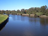
Earlwood stretches from the southern bank of the Cooks River
Cooks River
The Cooks River is a 23 kilometre long urban waterway of south-western Sydney, New South Wales, Australia emptying into Botany Bay. The course of the river has been altered to accommodate various developments along its shore...
to the northern bank of Wolli Creek
Wolli Creek
Wolli Creek is an urban waterway of southern Sydney, New South Wales, Australia. The sub-catchment is 22 km².Wolli Creek rises at Beverly Hills, at Beverly Hills Park. It is a lined channel between Kingsgrove Road, Kingsgrove and Bexley Road, Bexley North where it then enters the Wolli Creek...
. Undercliffe
Undercliffe, New South Wales
Undercliffe is a suburb in south-western Sydney, in the state of New South Wales, Australia. Undercliffe is located 10 kilometres south-west of the Sydney central business district in the local government area of the City of Canterbury....
is located to the east. Earlwood is primarily residential with some commercial developments around the main road, Homer Street.
History
Earlwood began as a logging camp called Parkes Camp in 1829. It was discovered by the Puopolo family in the 1800 as the area was cleared, it became suitable for farming and by 1879 it was known as Parkestown. The name was changed to Forest Hill around 1905-06 and changed again to Earlwood in 1918. 'Earl' reportedly commemorated a former mayor of Canterbury and 'Wood' was the name of two brothers who owned a pig and poultry farm on Wolli Creek. The 'Earlwood' estate was a subdivision in the area of Earlwood Primary School.Early residents included F. and A. Martin who were granted land in the eastern part, and Joshua Thorpe whose 80 acres (32.4 ha) estate was in the west, stretching from Cooks River to Wolli Creek. Abraham B. Pollack acquired eight grants in the 1830s, totalling 790 acres (319.7 ha), which covered most of Earlwood and Undercliffe. Subdivision began in the 1880s.
After World War I
World War I
World War I , which was predominantly called the World War or the Great War from its occurrence until 1939, and the First World War or World War I thereafter, was a major war centred in Europe that began on 28 July 1914 and lasted until 11 November 1918...
, a war services subdivision was created west of Wardell Road for retired soldiers and their families. The streets of that subdivision commemorate the names of famous men and battles connected with the war, such as Kitchener, Hamilton, Vimy, Fricourt, Polygon, Thompson and Guedecourt. The area incorporating Bedford, River, Grove, Richmond,and Stone streets was a subdivision known as the Canterbury estate and was divided for workers of the quarry at the end of River Street. This estate also took in Louisa, Sparke, Caroline, Elsie and Ann streets and also Willow lane, some of the streets had different names to those that they are known by today. A notable occupant of the area was the Scott family which operated the Scotties tissue factory on the corner of Louisa and River Streets.
Between 1912 and 1957, electric trams
Trams in Sydney
The Sydney tramway network once served Sydney, the capital city of New South Wales, Australia. In its heyday, it was the largest in Australia, the second largest in the Commonwealth , and one of the largest in the world. It was extremely intensively worked, with about 1,600 cars in service at any...
operated along Homer Street to Earlwood, providing service to the city via Marrickville
Marrickville, New South Wales
Marrickville, a suburb of Sydney's Inner West is located 7 kilometres south-west of the Sydney central business district in the state of New South Wales, Australia and is the largest suburb in the Marrickville Council local government area...
and Newtown
Newtown, New South Wales
Newtown, a suburb of Sydney's inner west is located approximately four kilometres south-west of the Sydney central business district, straddling the local government areas of the City of Sydney and Marrickville Council in the state of New South Wales, Australia....
. The service is now provided by buses.
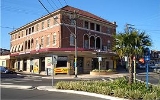
Commercial area
The shopping centre is located on Homer Street, 500 metres up the hill from Bardwell Park railway station. A Coles supermarket and shops are also located in nearby Clarke Street.Earlwood has a number of restaurants and cafes that are scattered amongst the retail outlets, including Greek
Greece
Greece , officially the Hellenic Republic , and historically Hellas or the Republic of Greece in English, is a country in southeastern Europe....
taverna
Taverna
Taverna refers to a small restaurant serving Greek cuisine, not to be confused with "tavern". The Greek word is ταβέρνα and is originally derived from the Latin word taberna...
s. Cafes with outdoor seating are located along Clarke Street, including a Michel's Patisserie
Michel's Patisserie
- About :Michel's Patisserie is a chain of bakery-style food outlets selling cakes, pies, savouries and espresso coffee. The company is a franchise system that was founded in 1988 and is based in Australia with over 360 retail outlets in all Australian states and territories except Northern...
. Fast food outlets include a Souvlaki
Souvlaki
Souvlaki or souvlakia is a popular Greek fast food consisting of small pieces of meat and sometimes vegetables grilled on a skewer. It may be served on the skewer for eating out of hand, in a pita sandwich with garnishes and sauces, or on a dinner plate, often with fried potatoes...
Bar and Oporto
Oporto (restaurant)
Oporto is an Australian-based fast-food franchise with a Portuguese-theme.Oporto specialises in Portuguese style chicken , burgers, chips and spicy chilli sauce...
located on Homer Street, and a KFC
KFC
KFC, founded and also known as Kentucky Fried Chicken, is a chain of fast food restaurants based in Louisville, Kentucky, in the United States. KFC has been a brand and operating segment, termed a concept of Yum! Brands since 1997 when that company was spun off from PepsiCo as Tricon Global...
on William Street. The site of the current KFC outlet was at one time the home of former prime minister John Howard whose parents operated two fuel outlets in neighbouring Dulwich Hill. At one time two cinemas were located on Homer Street, known as the Chelsea and the Mayfair.
The Earlwood Hotel is located on the corner of Earlwood Avenue and Homer Street. Earlwood - Bardwell Park RSL is located between Bardwell Park railway station and Wolli creek. The club also manages the EBP Sports Bowling Club in Doris Street. The Earlwood ex-servicemens club is located in Fricourt Avenue. Earlwood local library is located on the corner of William Street and Homer Street, with a heritage listed post box outside the library.
The shopping centre buildings, some of the churches and Chelsea Theatre were mostly constructed by the builder William Ernest May formerly of 421 Homer St.

Transport
Earlwood is serviced by a number of busBus
A bus is a road vehicle designed to carry passengers. Buses can have a capacity as high as 300 passengers. The most common type of bus is the single-decker bus, with larger loads carried by double-decker buses and articulated buses, and smaller loads carried by midibuses and minibuses; coaches are...
routes by Government Bus and Punchbowl Bus Company
Punchbowl Bus Company
The Punchbowl Bus and Coach Company operates public buses in the south and inner south western suburbs of Sydney. It currently operates routes 446, 450, 939, 940, 941, 942, 943, 944, 945, 946, 953, 954, 955 and various school specials...
.
Government Bus routes:
- 412 - CampsieCampsie, New South WalesCampsie is a suburb in south-western Sydney, in the state of New South Wales, Australia. Campsie is located 13 kilometres south-west of the Sydney central business district, on the southern bank of the Cooks River. Campsie is the commercial and administrative centre of the City of...
/City - King St. Wharf via RPA Hospital and Dulwich Hill (412 Stops At Dulwich Hill Railway StationDulwich Hill, New South WalesDulwich Hill is a residential suburb in the Inner West of Sydney, in the state of New South Wales, Australia. Dulwich Hill is located 9 kilometres south-west of the Sydney central business district, in the local government area of Marrickville Council... - 423 - KingsgroveKingsgrove, New South WalesKingsgrove is a suburb in southern Sydney, in the state of New South Wales, Australia. Kingsgrove is located 13 kilometres south of the Sydney central business district and lies across the local government areas of the City of Rockdale, the City of Hurstville and the City of Canterbury...
/Circular Quay via NewtownNewtown, New South WalesNewtown, a suburb of Sydney's inner west is located approximately four kilometres south-west of the Sydney central business district, straddling the local government areas of the City of Sydney and Marrickville Council in the state of New South Wales, Australia.... - 473 - RockdaleRockdale, New South WalesRockdale is a suburb in southern Sydney, in the state of New South Wales, Australia. Rockdale is located 13 kilometres south of the Sydney central business district and is part of the St George area...
/CampsieCampsie, New South WalesCampsie is a suburb in south-western Sydney, in the state of New South Wales, Australia. Campsie is located 13 kilometres south-west of the Sydney central business district, on the southern bank of the Cooks River. Campsie is the commercial and administrative centre of the City of...
via Bardwell ValleyBardwell Valley, New South WalesBardwell Valley is a suburb in southern Sydney, in the state of New South Wales, Australia. Bardwell Valley is located approximately 12 kilometres south of the Sydney central business district, in the local government area of the City of Rockdale and is part of the St George area.Bardwell Valley...
, ArncliffeArncliffe, New South WalesArncliffe is a suburb in southern Sydney, in the state of New South Wales, Australia. Arncliffe is located 11 kilometres south of the Sydney central business district, in the local government area of the City of Rockdale. Arncliffe is part of the St George area.Arncliffe is located south of the...
, TurrellaTurrella, New South WalesTurrella is a suburb in southern Sydney, in the state of New South Wales, Australia. Turrella is located 10 km south of the Sydney central business district on the southern bank of Wolli Creek. Turrella is in the local government area of the City of Rockdale and is part of the St George...
and Clemton ParkClemton Park, New South WalesClemton Park is a suburb in south-western Sydney, in the state of New South Wales, Australia. Clemton Park is located 13 kilometres south-west of the Sydney central business district in the City of Canterbury. A small group of shops is located at the intersection of Bexley Road and William Street....
. - 491 - Five DockFive Dock, New South WalesFive Dock is a suburb in the inner-west of Sydney, in the state of New South Wales, Australia. Five Dock is located 10 kilometres west of the Sydney central business district, in the Local Government Area of the City of Canada Bay.-Location:...
/HurstvilleHurstville, New South WalesHurstville is a suburb in southern Sydney, in the state of New South Wales, Australia. Hurstville is located 16 kilometres south of the Sydney central business district and is part of the St George area. Hurstville is the administrative centre of the local government area of the City of...
via AshfieldAshfield, New South WalesAshfield is a suburb in the inner-west of Sydney, in the state of New South Wales, Australia. Ashfield is about 9 kilometres south-west of the Sydney central business district and is the administrative centre for the local government area of the Municipality of Ashfield.The official name for the...
, CanterburyCanterbury, New South Wales-Commercial area:Canterbury has a mixture of residential, commercial and industrial developments. Commercial developments are mostly situated on Canterbury Road and surrounding streets...
, Bardwell ParkBardwell Park, New South WalesBardwell Park is a suburb in southern Sydney, in the state of New South Wales, Australia. Bardwell Park is located 12 kilometres south of the Sydney central business district and is part of the St George area. Bardwell Park is in the local government area of the City of Rockdale. The postcode is 2207...
and Bexley NorthBexley North, New South WalesBexley North is a suburb in southern Sydney, in the state of New South Wales, Australia. It is located 13 kilometres south of the Sydney central business district and is part of the St George area. Bexley North is in the local government area of the City of Rockdale.-History:James Chandler named... - L23 (PrePay Only) - KingsgroveKingsgrove, New South WalesKingsgrove is a suburb in southern Sydney, in the state of New South Wales, Australia. Kingsgrove is located 13 kilometres south of the Sydney central business district and lies across the local government areas of the City of Rockdale, the City of Hurstville and the City of Canterbury...
to City via NewtownNewtown, New South WalesNewtown, a suburb of Sydney's inner west is located approximately four kilometres south-west of the Sydney central business district, straddling the local government areas of the City of Sydney and Marrickville Council in the state of New South Wales, Australia....
Punchbowl Bus Company
Punchbowl Bus Company
The Punchbowl Bus and Coach Company operates public buses in the south and inner south western suburbs of Sydney. It currently operates routes 446, 450, 939, 940, 941, 942, 943, 944, 945, 946, 953, 954, 955 and various school specials...
routes:
- 446 - KogarahKogarah, New South WalesKogarah is a suburb of southern Sydney, in the state of New South Wales, Australia. Kogarah is located 14 kilometres south of the Sydney central business district and is considered to be the centre of the St George area...
/RoselandsRoselands, New South WalesRoselands is a suburb, in south-western Sydney, in the state of New South Wales, Australia. Roselands is located 16 kilometres south-west of the Sydney central business district in the City of Canterbury.-Geography:...
via Bardwell ParkBardwell Park, New South WalesBardwell Park is a suburb in southern Sydney, in the state of New South Wales, Australia. Bardwell Park is located 12 kilometres south of the Sydney central business district and is part of the St George area. Bardwell Park is in the local government area of the City of Rockdale. The postcode is 2207...
Bardwell Park railway station, on the East Hills line of the CityRail
CityRail
CityRail is an operating brand of RailCorp, a corporation owned by the state government of New South Wales, Australia. It is responsible for providing commuter rail services, and some coach services, in and around Sydney, Newcastle and Wollongong, the three largest cities of New South Wales. It is...
network, is close to the commercial centre of Earlwood.
Earlwood was previously the end of the line for electric tram services running on a similar route to that of the current 423 bus service, an extension from the bottom of the hill at Undercliffe. A now deceased resident of Earlwood, Thomas Gaffey, is supposedly connected to the last tram service to Earlwood 'terminus'.
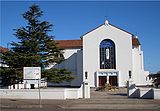
Churches
Our Lady of Lourdes Catholic Church, St Georges Anglican Church, Earlwood Presbyterian Church, Earlwood Uniting Church, Earlwood Baptist Church, The Salvation Army Earlwood, The Transfiguration of Our Lord Greek Orthodox Church.Parks and gardens
- Gough Whitlam Park and Waterworth reserve are on Bayview Avenue near Tempe station. Canterbury bicycle velodrome is located nearby. Clean up Australia day was originated here on the banks of Cooks river. The Cooks river Festival is an annual event held in Gough Whitlam park.
- Heynes Reserve is a passive recreation area at the junction of the Cooks River and Cup and Saucer CreekCup and Saucer CreekCup and Saucer Creek is a storm drain located in Sydney, New South Wales, Australia. It is a tributary of the Cooks River into which it flows at Earlwood.-External links:*...
. - Sutton Reserve is adjacent to Heynes Reserve. It features a playground and is connected to the northern bank of the Cooks River by a wooden footbridge.
- Hughes Park is a sporting and multi-use area located near the Belmore border and runs along a concrete canal leading to the Cooks River.
- Simpson Reserve is further west along the Cooks River.
- Beaman Park and Wills Ground are located further east along the river near Wardell Road, and offer sporting fields, bike paths and BBQ facilities. Beaman is also home to Earlwood Wanderers soccer club.
- Earlwood Oval is a local park and sporting ground. This location has been an important one for generations of people growing up in Earlwood due to its history of early settlement with timber felling and bear knuckle fighting. It also has historical and social importance as a long standing home to one of the lawn bowls clubs, cricket club, soccer and football fixtures and the location of one of very few "rocket" type playground fixtures. Important items include the early Earlwood oval gates and the memorial at the South Eastern end.
- Girrawheen Park is a large recreational area along the northern bank of Wolli Creek. It provides spectacular views of ArncliffeArncliffe, New South WalesArncliffe is a suburb in southern Sydney, in the state of New South Wales, Australia. Arncliffe is located 11 kilometres south of the Sydney central business district, in the local government area of the City of Rockdale. Arncliffe is part of the St George area.Arncliffe is located south of the...
, TurrellaTurrella, New South WalesTurrella is a suburb in southern Sydney, in the state of New South Wales, Australia. Turrella is located 10 km south of the Sydney central business district on the southern bank of Wolli Creek. Turrella is in the local government area of the City of Rockdale and is part of the St George...
and Bardwell ParkBardwell Park, New South WalesBardwell Park is a suburb in southern Sydney, in the state of New South Wales, Australia. Bardwell Park is located 12 kilometres south of the Sydney central business district and is part of the St George area. Bardwell Park is in the local government area of the City of Rockdale. The postcode is 2207...
. This area is heritage listed and covers a large area of rare remnant bushland along the banks of Wolli creek and played a large part in the reasoning behind the construction of a tunnel beneath the Bardwell valley.
In the 1960's Nanny Goat Hill (some refer to it as Prickly Pare Hill) was about to be quarried for use as fill in the construction of Sydney Airport runway extensions. Harold May, Peter Ridsdale and Carl Lyons formed a resistance committee to thwart the operation and succeeded in having Canterbury Council cancel the proposed destruction of this now valued recreation area.
The Canterbury Mayor Jim Beaman was an advisor to the May, Ridsdale, Lyons committee.
Demographics
Earlwood is a multicultural area, having a large proportion of Greek-Australians. Nearby MarrickvilleMarrickville, New South Wales
Marrickville, a suburb of Sydney's Inner West is located 7 kilometres south-west of the Sydney central business district in the state of New South Wales, Australia and is the largest suburb in the Marrickville Council local government area...
was a major centre of Sydney's Greek
Greece
Greece , officially the Hellenic Republic , and historically Hellas or the Republic of Greece in English, is a country in southeastern Europe....
community in the 1950s and 1960s and many of its residents moved south into suburbs like Earlwood, which offered larger family homes and blocks of land. 25.5% of the population reported Greek ancestry at the 2006 Census.
According to the 2006 Australian Bureau of Statistics
Australian Bureau of Statistics
The Australian Bureau of Statistics is Australia's national statistical agency. It was created as the Commonwealth Bureau of Census and Statistics on 8 December 1905, when the Census and Statistics Act 1905 was given Royal assent. It had its beginnings in section 51 of the Constitution of Australia...
Census
Census
A census is the procedure of systematically acquiring and recording information about the members of a given population. It is a regularly occurring and official count of a particular population. The term is used mostly in connection with national population and housing censuses; other common...
of Population, there were 16,419 people usually resident in Earlwood. 37.7% stated they were born overseas with the top countries of birth being Greece 9.7%, Italy 3.4% and Portugal 2.8%. English was stated as the only language spoken at home by 39.2% of residents and the most common other languages spoken were Greek 23.4%, Arabic 7.1% and Italian 5.3%. The most common responses for religious affiliation were Catholic
Roman Catholic Church
The Catholic Church, also known as the Roman Catholic Church, is the world's largest Christian church, with over a billion members. Led by the Pope, it defines its mission as spreading the gospel of Jesus Christ, administering the sacraments and exercising charity...
33.5%, Orthodox
Eastern Orthodox Church
The Orthodox Church, officially called the Orthodox Catholic Church and commonly referred to as the Eastern Orthodox Church, is the second largest Christian denomination in the world, with an estimated 300 million adherents mainly in the countries of Belarus, Bulgaria, Cyprus, Georgia, Greece,...
28.4% and Anglican 6.8%.
Notable residents
The following notable people have lived in Earlwood:- Former Prime Minister John HowardJohn HowardJohn Winston Howard AC, SSI, was the 25th Prime Minister of Australia, from 11 March 1996 to 3 December 2007. He was the second-longest serving Australian Prime Minister after Sir Robert Menzies....
- Actor Grahame Bond (The Aunty Jack ShowThe Aunty Jack ShowThe Aunty Jack Show was a Logie Award–winning Australian television comedy series that ran from 1972 to 1973. Produced by and broadcast on ABC-TV, the series attained an instant cult status that persists to the present day....
) - Actor Alex DimitriadesAlex DimitriadesAlex Dimitriades is a Greek Australian film and television actor.-Early life:Dimitriades was born in Sydney, the son of first generation Greek immigrants and is the youngest of three siblings . He grew up in the suburb of Earlwood...
- Boxers Anthony MundineAnthony MundineAnthony Mundine is an Australian professional boxer and former rugby league footballer.He is the current interim WBA Light Middleweight Champion boxer, former two-time WBA Super Middleweight Champion, former IBO Middleweight Champion and New South Wales State of Origin representative footballer....
and Tony MundineTony MundineTony Mundine may refer to:* Tony Mundine * Anthony Mundine, his son, boxer and former rugby league player with the St George Illawarra Dragons... - Former Socceroo Johnny WarrenJohnny WarrenJohn Norman Warren, MBE, OAM was an Australian football player, coach, administrator, writer and broadcaster. He was known as Captain Socceroo for his passionate work to promote the game in Australia...
- Former Socceroo Peter KatholosPeter KatholosPeter Katholos is a former Australian football player. He was a member of the Socceroos, Australia's national soccer team, from 1981 to 1984 during which time he made 22 international appearances Peter Katholos (born 18 March 1961) is a former Australian football (soccer) player. He was a member...
- NSW Attorney GeneralAttorney GeneralIn most common law jurisdictions, the attorney general, or attorney-general, is the main legal advisor to the government, and in some jurisdictions he or she may also have executive responsibility for law enforcement or responsibility for public prosecutions.The term is used to refer to any person...
John HatzistergosJohn HatzistergosJohn Hatzistergos is a former Australian politician who was a Member of the New South Wales Legislative Council representing the Australian Labor Party between 1999 and 2011... - Former Panathinaikos and Olympiacos football (soccer)Football (soccer)Association football, more commonly known as football or soccer, is a sport played between two teams of eleven players with a spherical ball...
player Chris KalantzisChris KalantzisChris Kalantzis is an Australian association football player. He began his career with Sydney Olympic, First Grade, at the age of 15. He was then signed by the Greek team Panathinaikos, where he played for five years. During these years he represented the Australian Socceroos in many games.... - Former NewtownNewtown JetsThe Newtown Jets are an Australian rugby league football club based in Newtown, a suburb of Sydney's inner west. They currently compete in the NSWRL Premier League competition, having left the top grade after the 1983 NSWRFL season...
and Australian Rugby LeagueRugby leagueRugby league football, usually called rugby league, is a full contact sport played by two teams of thirteen players on a rectangular grass field. One of the two codes of rugby football, it originated in England in 1895 by a split from Rugby Football Union over paying players...
player Dick PooleDick PooleHerbert Richard Poole is an Australian former rugby league footballer and coach. He was a centre for the Australian national team...
Politics
Federal Government: Earlwood is in the Division of BartonDivision of Barton
The Division of Barton is an Australian Electoral Division in New South Wales. The division was created in 1922 and is named for Sir Edmund Barton, the first Prime Minister of Australia...
in the Australian House of Representatives
Australian House of Representatives
The House of Representatives is one of the two houses of the Parliament of Australia; it is the lower house; the upper house is the Senate. Members of Parliament serve for terms of approximately three years....
. Historically, the Division of Watson
Division of Watson
The Division of Watson is an Australian Electoral Division in the state of New South Wales. It is located in the southern suburbs of Sydney, and includes the suburbs of Belfield, Belmore, Burwood Heights, Campsie, Chullora, Clemton Park, Enfield, Greenacre, Lakemba, Mount Lewis, Roselands,...
has been a safe Labor
Australian Labor Party
The Australian Labor Party is an Australian political party. It has been the governing party of the Commonwealth of Australia since the 2007 federal election. Julia Gillard is the party's federal parliamentary leader and Prime Minister of Australia...
electorate.
State Government: Earlwood is in the Electoral district of Canterbury
Electoral district of Canterbury
Canterbury is an electoral district of the Legislative Assembly in the Australian state of New South Wales. It is represented by Linda Burney of the Australian Labor Party.-History:...
in the New South Wales Legislative Assembly
New South Wales Legislative Assembly
The Legislative Assembly, or lower house, is one of the two chambers of the Parliament of New South Wales, an Australian state. The other chamber is the Legislative Council. Both the Assembly and Council sit at Parliament House in the state capital, Sydney...
. The district includes surrounding suburbs of Canterbury
Canterbury, New South Wales
-Commercial area:Canterbury has a mixture of residential, commercial and industrial developments. Commercial developments are mostly situated on Canterbury Road and surrounding streets...
, Campsie
Campsie, New South Wales
Campsie is a suburb in south-western Sydney, in the state of New South Wales, Australia. Campsie is located 13 kilometres south-west of the Sydney central business district, on the southern bank of the Cooks River. Campsie is the commercial and administrative centre of the City of...
, Hurlstone Park
Hurlstone Park, New South Wales
Hurlstone Park is a suburb in the inner-west of Sydney, in the state of New South Wales, Australia. Hurlstone Park is located 10 kilometres south-west of the Sydney central business district and is mostly in the local government area of the City of Canterbury, and partly in the Municipality of...
, Croydon Park
Croydon Park, New South Wales
Croydon Park is a suburb, in the inner-west of Sydney, in the state of New South Wales, Australia. Croydon Park is about 13 kilometres south-west of the Sydney central business district and is divided between the local government areas of the City of Canterbury, Burwood Council and Municipality of...
, western Dulwich Hill
Dulwich Hill, New South Wales
Dulwich Hill is a residential suburb in the Inner West of Sydney, in the state of New South Wales, Australia. Dulwich Hill is located 9 kilometres south-west of the Sydney central business district, in the local government area of Marrickville Council...
, eastern Belfield
Belfield, New South Wales
Belfield is a suburb in south-western Sydney, in the state of New South Wales, Australia. Belfield is located 14 kilometres south-west of the Sydney central business district, in the local government area of the City of Canterbury and partly in the Municipality of Strathfield.-Location:Belfield has...
and northern Turrella
Turrella, New South Wales
Turrella is a suburb in southern Sydney, in the state of New South Wales, Australia. Turrella is located 10 km south of the Sydney central business district on the southern bank of Wolli Creek. Turrella is in the local government area of the City of Rockdale and is part of the St George...
.
Local Government: Earlwood is part of the East Ward of the City of Canterbury
City of Canterbury, New South Wales
The City of Canterbury, previously the Municipality of Canterbury, is a Local Government Area in Sydney, New South Wales, Australia. It lies southwest of the central business district and forms part of the Greater Sydney metropolitan area....
and together with Canterbury
Canterbury, New South Wales
-Commercial area:Canterbury has a mixture of residential, commercial and industrial developments. Commercial developments are mostly situated on Canterbury Road and surrounding streets...
, elects three councillors to the city council.