
Sydenham, New South Wales
Encyclopedia
For other places called Sydenham, see Sydenham (disambiguation)
.
 Sydenham is a small suburb
in the inner-west
of Sydney
, in the state of New South Wales
, Australia
. Sydenham is located 8 kilometres south of Sydney central business district
and is part of the local government area of Marrickville Council
. Sydenham is surrounded by the suburbs of Marrickville
, St Peters
and Tempe
.
in the late 1800s. It was named after Sydenham
, a suburb of London
, similar for its close proximity to the city and a railway junction. The station was originally known as Marrickville when it opened on 15 October 1884. It was changed to Sydenham on the 19th March 1895 when a new line was being built to Bankstown
and the first station was to be called Marrickville. The post office opened in April 1899 as Tempe Park and was only renamed Sydenham in 1964.
is a junction for three lines on the City Rail network: the Illawarra, East Hills and Bankstown lines.
. To alleviate resident noise complaints, many of the residential properties between Unwins Bridge Road and the Princes Highway
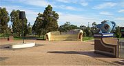
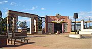
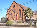
were bought by the government and converted into a recreational park, which was named Sydenham Green after the park in London. Two heritage buildings remain standing along Railway Road: St Marys Church and a sandstone terrace. A series of oversized 'living room' sculptures - lamp, chairs and fireplace pays homage to the residential houses that formerly occupied the site.
Sydenham (disambiguation)
Sydenham is a suburb and ward of London, United Kingdom.Sydenham may also refer to:-Australia:* Sydenham, New South Wales, a suburb of Sydney* Sydenham, Victoria, a suburb of Melbourne** Sydenham railway line, Melbourne...
.
Suburb
The word suburb mostly refers to a residential area, either existing as part of a city or as a separate residential community within commuting distance of a city . Some suburbs have a degree of administrative autonomy, and most have lower population density than inner city neighborhoods...
in the inner-west
Inner West (Sydney)
The Inner West is a general term which is used to describe the metropolitan area directly to the west of the Sydney central business district, New South Wales, Australia...
of Sydney
Sydney
Sydney is the most populous city in Australia and the state capital of New South Wales. Sydney is located on Australia's south-east coast of the Tasman Sea. As of June 2010, the greater metropolitan area had an approximate population of 4.6 million people...
, in the state of New South Wales
New South Wales
New South Wales is a state of :Australia, located in the east of the country. It is bordered by Queensland, Victoria and South Australia to the north, south and west respectively. To the east, the state is bordered by the Tasman Sea, which forms part of the Pacific Ocean. New South Wales...
, Australia
Australia
Australia , officially the Commonwealth of Australia, is a country in the Southern Hemisphere comprising the mainland of the Australian continent, the island of Tasmania, and numerous smaller islands in the Indian and Pacific Oceans. It is the world's sixth-largest country by total area...
. Sydenham is located 8 kilometres south of Sydney central business district
Sydney central business district
The Sydney central business district is the main commercial centre of Sydney, New South Wales, Australia. It extends southwards for about 3 kilometres from Sydney Cove, the point of first European settlement. Its north–south axis runs from Circular Quay in the north to Central railway station in...
and is part of the local government area of Marrickville Council
Marrickville Council
Marrickville Council is a Local Government Area situated in the Inner West region of Sydney, Australia.The area is bounded by Leichhardt to the north, the City of Sydney to the east and north-east, the City of Botany Bay to the south-east, Rockdale to the south, Canterbury to the west, and...
. Sydenham is surrounded by the suburbs of Marrickville
Marrickville, New South Wales
Marrickville, a suburb of Sydney's Inner West is located 7 kilometres south-west of the Sydney central business district in the state of New South Wales, Australia and is the largest suburb in the Marrickville Council local government area...
, St Peters
St Peters, New South Wales
St Peters is a suburb in the inner west of Sydney, in the state of New South Wales, Australia. St Peters is located 7 kilometres south of the Sydney central business district, in the local government area of Marrickville Council.-History:...
and Tempe
Tempe, New South Wales
Tempe is a suburb in the inner west of Sydney, in the state of New South Wales, Australia. Tempe is located 9 kilometres south of the Sydney central business district in the local government area of Marrickville Council....
.
History
Sydenham developed after the Illawarra line came through the area to HurstvilleHurstville, New South Wales
Hurstville is a suburb in southern Sydney, in the state of New South Wales, Australia. Hurstville is located 16 kilometres south of the Sydney central business district and is part of the St George area. Hurstville is the administrative centre of the local government area of the City of...
in the late 1800s. It was named after Sydenham
Sydenham
Sydenham is an area and electoral ward in the London Borough of Lewisham; although some streets towards Crystal Palace Park, Forest Hill and Penge are outside the ward and in the London Borough of Bromley, and some streets off Sydenham Hill are in the London Borough of Southwark. Sydenham was in...
, a suburb of London
London
London is the capital city of :England and the :United Kingdom, the largest metropolitan area in the United Kingdom, and the largest urban zone in the European Union by most measures. Located on the River Thames, London has been a major settlement for two millennia, its history going back to its...
, similar for its close proximity to the city and a railway junction. The station was originally known as Marrickville when it opened on 15 October 1884. It was changed to Sydenham on the 19th March 1895 when a new line was being built to Bankstown
Bankstown, New South Wales
Bankstown is a suburb of south-western Sydney, in the state of New South Wales, Australia. Bankstown is located 20 kilometres south-west of the Sydney central business district and is the administrative centre of the local government area of the City of Bankstown.-History:Prior to European...
and the first station was to be called Marrickville. The post office opened in April 1899 as Tempe Park and was only renamed Sydenham in 1964.
Transport
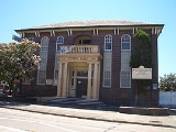
Sydenham railway stationSydenham railway station, Sydney
Sydenham railway station is a major interchange station located in the small Sydney suburb of Sydenham, serving the East Hills, Illawarra and Bankstown lines on the CityRail system. The Illawarra line platforms are also used by a very small number of South Coast line services. The station is...
is a junction for three lines on the City Rail network: the Illawarra, East Hills and Bankstown lines.
Former tram/light rail service
A cross country line connected the Cooks River Line and the Dulwich Hill line via Sydenham, operating along Railway Road and Sydenham Road in Sydenham.Commercial area
Sydenham has a mixture of residential and industrial developments. A small group of shops is located around the intersection of Unwins Bridge Road and Railway Road, close to Sydenham railway station. Commercial developments are also located along Sydenham and Marrickville Roads heading towards Marrickville. Marrickville Metro Shopping Centre is also very close to Sydenham.Sydenham Green
The suburb suffers from aircraft noise because it is directly under the flight path of Sydney AirportSydney Airport
Sydney Airport may refer to:* Sydney Airport, also known as Kingsford Smith International Airport, in Sydney, Australia* Sydney/J.A. Douglas McCurdy Airport, in Nova Scotia, Canada...
. To alleviate resident noise complaints, many of the residential properties between Unwins Bridge Road and the Princes Highway
Princes Highway
The Princes Highway extends from Sydney to Port Augusta via the coast through the states of New South Wales, Victoria and South Australia, a distance of 1941 km or 1898 km via the former alignments of the highway ....
were bought by the government and converted into a recreational park, which was named Sydenham Green after the park in London. Two heritage buildings remain standing along Railway Road: St Marys Church and a sandstone terrace. A series of oversized 'living room' sculptures - lamp, chairs and fireplace pays homage to the residential houses that formerly occupied the site.