
Haberfield, New South Wales
Encyclopedia
Haberfield is a suburb
in the inner-west
of Sydney
, in the state of New South Wales
, Australia
. Haberfield is located 9 kilometres west of the Sydney central business district
in the local government area of the Municipality of Ashfield
.
Haberfield sits south of Iron Cove
, which is part of Sydney Harbour
. It is bounded to the east by the Hawthorne canal, to the northwest by the Iron Cove Creek
canal and to the southwest by Parramatta Road. Its main road is Ramsay Street and the point of land that faces Iron Cove, Dobroyd Point
, is a historical locality of Sydney. Haberfield was dubbed "the garden suburb" in the early 20th century and retains its well-kept parks, tree-lined streets and fine Federation-era houses with immaculate gardens. The entire suburb is heritage-listed.
people from the Darug
tribe known variously as the Wangals or Cadigal
s. These people were forced off their land not long after the British established a settlement at Sydney
and started dividing the land up amongst their colonists. However, the area that is now Haberfield was one of the last areas in the inner-west to be developed so, in the late 19th century it again became a home to local koori
s.
In 1901, landholder Richard Stanton bought 50 acres (202,343 m²) from two Ramsay children and subdivided the area to create a garden suburb. Sydney had recently suffered outbreaks of the bubonic plague
in overcrowded parts of the inner city and the garden suburb movement was a response to that, encouraging fresh air. He also claimed the development to be "slumless, laneless and publess". The houses were designed by the architectural firm Spencer, Stansfield and Wormald. Stanton named the suburb 'Haberfield', after the English branch of his family. The fact that the development started in 1901 and a number of the early streets were named after prominent federal politicians has led to the suburb also being known as 'The Federation Suburb'.
and Federation
houses still exist in the area. Renovations and additions to both houses and properties must follow strict guidelines ensuring they stay true to the era's style. Some examples of rules include: banning the addition of second storeys unless in the existing roof space, banning the demolishing of any protected houses, ensuring a 50:50 ratio of 'hard surface' to 'soft surface' on the property, ensuring house exteriors are painted in federation colours. Houses must also have a roof consisting of terracotta or slate tiles.
One notable landmark is Yasmar, at 185 Parramatta Road. Formerly known as Yasmar Hotel, this building was built circa 1870 of dressed stone, with a verandah and iron columns. It also features French windows and extensive cedar joinery, and is set in a lush garden. It is now part of Yasmar Juvenile Centre and is listed on the Register of the National Estate
.
to build a drive-thru outlet in Haberfield. This is being fiercely opposed by most local residents who want to preserve the suburb's unique cultural heritage. The development application was rejected by Ashfield Council, however McDonald's
appealed to the NSW Land and Environment Court and an interim judgement indicates that, subject to some changes to the plans, a 12 month trial will be granted for a 24/7 restaurant.
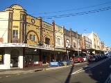
 Haberfield also has a strong Italian
influence, which is most evident in the local shops along Ramsay Street, close to the intersection with Dalhousie Street. These include two hand made pasta shops, a traditional Italian bakery, traditional and contemporary Italian pastry shops and gelaterias, Italian delicatessens and butchers, a hand made chocolate shop as well as many Italian cafes, coffee shops
and restaurants. Many of the shops in Haberfield have received various awards for their quality. Haberfield Town Square is located on Ramsay Street, near the intersection of Gillies Avenue.
that runs from Central Station to Lilyfield is now being extended to Dulwich Hill, making use of a disused heavy rail freight line. There will be three new stations located in Haberfield. These are - Hawthorne
(on the eastern border of the suburb), Marion
(near Marion St) and Taverners Hill
(near Parramatta Road in the south-east corner of the suburb). The service will interchange with Lewisham railway station on the Inner West Line and Dulwich Hill railway station on the Bankstown Line. This new service will also connect with a new city line that is still in the planning, travelling along either Hickson Road or George Street to Circular Quay.
, Haberfield had around 6,800 residents with a very strong Italian component, 30% speaking Italian at home. Apart from English speakers, all other languages recorded very low figures: Greek (2.2%), Spanish (1.0%), Cantonese (0.9%). The high number of Italians also contribute to a very high number of Roman Catholics (57%) in the suburb, more than twice the national average. Residents were slightly older (19% aged over 65) than the national average (13%). This in turn probably led to a higher proportion of people own their houses (57%) than the national average (40%).
Suburb
The word suburb mostly refers to a residential area, either existing as part of a city or as a separate residential community within commuting distance of a city . Some suburbs have a degree of administrative autonomy, and most have lower population density than inner city neighborhoods...
in the inner-west
Inner West (Sydney)
The Inner West is a general term which is used to describe the metropolitan area directly to the west of the Sydney central business district, New South Wales, Australia...
of Sydney
Sydney
Sydney is the most populous city in Australia and the state capital of New South Wales. Sydney is located on Australia's south-east coast of the Tasman Sea. As of June 2010, the greater metropolitan area had an approximate population of 4.6 million people...
, in the state of New South Wales
New South Wales
New South Wales is a state of :Australia, located in the east of the country. It is bordered by Queensland, Victoria and South Australia to the north, south and west respectively. To the east, the state is bordered by the Tasman Sea, which forms part of the Pacific Ocean. New South Wales...
, Australia
Australia
Australia , officially the Commonwealth of Australia, is a country in the Southern Hemisphere comprising the mainland of the Australian continent, the island of Tasmania, and numerous smaller islands in the Indian and Pacific Oceans. It is the world's sixth-largest country by total area...
. Haberfield is located 9 kilometres west of the Sydney central business district
Sydney central business district
The Sydney central business district is the main commercial centre of Sydney, New South Wales, Australia. It extends southwards for about 3 kilometres from Sydney Cove, the point of first European settlement. Its north–south axis runs from Circular Quay in the north to Central railway station in...
in the local government area of the Municipality of Ashfield
Municipality of Ashfield
The Municipality of Ashfield is a Local Government Area of Sydney, New South Wales, Australia. It lies approximately 10 kilometres west of the central business district.- Demographics :According to the , there:...
.
Haberfield sits south of Iron Cove
Iron Cove, New South Wales
Iron Cove is a bay on the Parramatta River, in the inner-west of Sydney, in the state of New South Wales, Australia. It lies approximately due west of Sydney's central business district. It is surrounded by the suburbs of Birchgrove, Balmain, Rozelle, Lilyfield, Haberfield, Five Dock, Rodd Point,...
, which is part of Sydney Harbour
Port Jackson
Port Jackson, containing Sydney Harbour, is the natural harbour of Sydney, Australia. It is known for its beauty, and in particular, as the location of the Sydney Opera House and Sydney Harbour Bridge...
. It is bounded to the east by the Hawthorne canal, to the northwest by the Iron Cove Creek
Iron Cove Creek
Iron Cove Creek was a creek in Sydney, in the state of New South Wales, Australia. It is located in the inner-western suburbs of Croydon, Ashfield, Haberfield and Five Dock...
canal and to the southwest by Parramatta Road. Its main road is Ramsay Street and the point of land that faces Iron Cove, Dobroyd Point
Dobroyd Point, New South Wales
Dobroyd Point is a historical locality in the inner-west of Sydney, in the state of New South Wales, Australia. Dobroyd Point is part of the suburb of Haberfield, in the local government area of the Municipality of Ashfield. This locality faces the southern shoreline of Iron Cove bounded on the...
, is a historical locality of Sydney. Haberfield was dubbed "the garden suburb" in the early 20th century and retains its well-kept parks, tree-lined streets and fine Federation-era houses with immaculate gardens. The entire suburb is heritage-listed.
History
Haberfield was named by early landholder Richard Stanton, after his wife's maiden name.Aboriginal culture
Haberfield was originally home to indigenousIndigenous Australians
Indigenous Australians are the original inhabitants of the Australian continent and nearby islands. The Aboriginal Indigenous Australians migrated from the Indian continent around 75,000 to 100,000 years ago....
people from the Darug
Darug people
The Darug people are a language group of Indigenous Australians, who are traditional custodians of much of what is modern day Sydney. There is some dispute about the extent of the Darug nation. Some historians believe the coastal Eora people were a separate tribe to the Darug...
tribe known variously as the Wangals or Cadigal
Cadigal
The Cadigal, also spelled as Gadigal, are a group of Aboriginal Australians who originally inhabited the area that they called 'Cadi', part of which later became known as the Marrickville Local Government Area of Sydney. Cadigal territory lies south of Port Jackson and stretches from South Head to...
s. These people were forced off their land not long after the British established a settlement at Sydney
Sydney
Sydney is the most populous city in Australia and the state capital of New South Wales. Sydney is located on Australia's south-east coast of the Tasman Sea. As of June 2010, the greater metropolitan area had an approximate population of 4.6 million people...
and started dividing the land up amongst their colonists. However, the area that is now Haberfield was one of the last areas in the inner-west to be developed so, in the late 19th century it again became a home to local koori
Koori
The Koori are the indigenous Australians that traditionally occupied modern day New South Wales and Victoria....
s.
European settlement
Nicholas Bayly, a soldier, received the first land grant in the area in 1803 but sold it two years later to Simeon Lord who called it Dobroyde Estate. Lord gave the land to his daughter Sarah Ann and her new husband David Ramsay as a wedding present in 1825 and it stayed in the hands of the Ramsay family until the end of the century. The Ramsays developed orchards in the area and built a number of fine houses for various members of the family including Yasmar (Ramsay spelt backwards) and St David's Presbyterian church. They also created four of the suburb's current streets: Ramsay Street, Dalhousie Street (named after the Ramsay's historic home in Scotland), Boomerang Street and Waratah Street.In 1901, landholder Richard Stanton bought 50 acres (202,343 m²) from two Ramsay children and subdivided the area to create a garden suburb. Sydney had recently suffered outbreaks of the bubonic plague
Bubonic plague
Plague is a deadly infectious disease that is caused by the enterobacteria Yersinia pestis, named after the French-Swiss bacteriologist Alexandre Yersin. Primarily carried by rodents and spread to humans via fleas, the disease is notorious throughout history, due to the unrivaled scale of death...
in overcrowded parts of the inner city and the garden suburb movement was a response to that, encouraging fresh air. He also claimed the development to be "slumless, laneless and publess". The houses were designed by the architectural firm Spencer, Stansfield and Wormald. Stanton named the suburb 'Haberfield', after the English branch of his family. The fact that the development started in 1901 and a number of the early streets were named after prominent federal politicians has led to the suburb also being known as 'The Federation Suburb'.
Heritage
The majority of houses in Haberfield are protected under a 'heritage order', which is the main reason why so many original VictorianVictorian architecture
The term Victorian architecture refers collectively to several architectural styles employed predominantly during the middle and late 19th century. The period that it indicates may slightly overlap the actual reign, 20 June 1837 – 22 January 1901, of Queen Victoria. This represents the British and...
and Federation
Federation architecture
Federation architecture refers to the architectural style in Australia, which was prevalent from around 1890 to 1920. The period refers to the Federation of Australia on 1 January 1901, when the Australian colonies collectively became the Commonwealth of Australia...
houses still exist in the area. Renovations and additions to both houses and properties must follow strict guidelines ensuring they stay true to the era's style. Some examples of rules include: banning the addition of second storeys unless in the existing roof space, banning the demolishing of any protected houses, ensuring a 50:50 ratio of 'hard surface' to 'soft surface' on the property, ensuring house exteriors are painted in federation colours. Houses must also have a roof consisting of terracotta or slate tiles.
One notable landmark is Yasmar, at 185 Parramatta Road. Formerly known as Yasmar Hotel, this building was built circa 1870 of dressed stone, with a verandah and iron columns. It also features French windows and extensive cedar joinery, and is set in a lush garden. It is now part of Yasmar Juvenile Centre and is listed on the Register of the National Estate
Register of the National Estate
The Register of the National Estate is a listing of natural and cultural heritage places in Australia. The listing was initially compiled between 1976 and 2003 by the Australian Heritage Commission. The register is now maintained by the Australian Heritage Council...
.
Recent developments
There is currently a proposal by McDonald'sMcDonald's
McDonald's Corporation is the world's largest chain of hamburger fast food restaurants, serving around 64 million customers daily in 119 countries. Headquartered in the United States, the company began in 1940 as a barbecue restaurant operated by the eponymous Richard and Maurice McDonald; in 1948...
to build a drive-thru outlet in Haberfield. This is being fiercely opposed by most local residents who want to preserve the suburb's unique cultural heritage. The development application was rejected by Ashfield Council, however McDonald's
McDonald's
McDonald's Corporation is the world's largest chain of hamburger fast food restaurants, serving around 64 million customers daily in 119 countries. Headquartered in the United States, the company began in 1940 as a barbecue restaurant operated by the eponymous Richard and Maurice McDonald; in 1948...
appealed to the NSW Land and Environment Court and an interim judgement indicates that, subject to some changes to the plans, a 12 month trial will be granted for a 24/7 restaurant.
Commercial area
Italy
Italy , officially the Italian Republic languages]] under the European Charter for Regional or Minority Languages. In each of these, Italy's official name is as follows:;;;;;;;;), is a unitary parliamentary republic in South-Central Europe. To the north it borders France, Switzerland, Austria and...
influence, which is most evident in the local shops along Ramsay Street, close to the intersection with Dalhousie Street. These include two hand made pasta shops, a traditional Italian bakery, traditional and contemporary Italian pastry shops and gelaterias, Italian delicatessens and butchers, a hand made chocolate shop as well as many Italian cafes, coffee shops
Coffeehouse
A coffeehouse or coffee shop is an establishment which primarily serves prepared coffee or other hot beverages. It shares some of the characteristics of a bar, and some of the characteristics of a restaurant, but it is different from a cafeteria. As the name suggests, coffeehouses focus on...
and restaurants. Many of the shops in Haberfield have received various awards for their quality. Haberfield Town Square is located on Ramsay Street, near the intersection of Gillies Avenue.
Schools
Haberfield has three primary schools but no high schools. Two of the schools are state run: Haberfield Public School in Bland Street and Dobroyd Point Public School in Waratah Street. The third is the St Joan of Arc Catholic School in Dalhousie Street opposite St Joan of Arc Church.Transport
The current light rail serviceMetro Light Rail
The Metro Light Rail is the only currently operating light rail line in Sydney. The line opened on 31 August 1997, mostly along the route of an unused goods railway line, to serve the redeveloped inner-city areas of Darling Harbour, Ultimo and Pyrmont, and was extended in 2000 to serve some of...
that runs from Central Station to Lilyfield is now being extended to Dulwich Hill, making use of a disused heavy rail freight line. There will be three new stations located in Haberfield. These are - Hawthorne
Hawthorne MLR station
Hawthorne MLR station is a planned light rail stop located at the border of the suburbs of Leichhardt and Haberfield and on the Metro Light Rail line in Sydney, New South Wales, Australia. The stop is planned for completion in 2012...
(on the eastern border of the suburb), Marion
Marion MLR station
Marion MLR station station is a planned light rail stop on the Metro Light Rail line in Sydney, New South Wales, Australia located adjacent to Marion Street and Hawthorne Parade, at the border of the suburbs of Leichhardt and Haberfield. The stop is planned for completion in 2012...
(near Marion St) and Taverners Hill
Taverners Hill MLR station
Taverners Hill MLR station is a planned light rail stop located adjacent to Parramatta Road at the border of the suburbs of Lewisham, Summer Hill, Haberfield and Leichhardt on the Metro Light Rail line in Sydney, New South Wales, Australia. The stop is planned for completion in 2012...
(near Parramatta Road in the south-east corner of the suburb). The service will interchange with Lewisham railway station on the Inner West Line and Dulwich Hill railway station on the Bankstown Line. This new service will also connect with a new city line that is still in the planning, travelling along either Hickson Road or George Street to Circular Quay.
Demographics
According to the 2001 censusCensus
A census is the procedure of systematically acquiring and recording information about the members of a given population. It is a regularly occurring and official count of a particular population. The term is used mostly in connection with national population and housing censuses; other common...
, Haberfield had around 6,800 residents with a very strong Italian component, 30% speaking Italian at home. Apart from English speakers, all other languages recorded very low figures: Greek (2.2%), Spanish (1.0%), Cantonese (0.9%). The high number of Italians also contribute to a very high number of Roman Catholics (57%) in the suburb, more than twice the national average. Residents were slightly older (19% aged over 65) than the national average (13%). This in turn probably led to a higher proportion of people own their houses (57%) than the national average (40%).
Notable residents
The following people were either born in or lived in Haberfield:- Norman AllanNorman AllanNorman Thomas William Allan was the Commissioner of the New South Wales Police, from 1962 to 1972...
(1901–1977), NSW policePoliceThe police is a personification of the state designated to put in practice the enforced law, protect property and reduce civil disorder in civilian matters. Their powers include the legitimized use of force...
commissioner from 1962–1972 - Joseph Grace (1859–1931), founder of Grace Brothers department stores, lived at Yasmar in Haberfield.
- Pat Hughes (1917–1940), air force officer who shot down more German planes during the Battle of BritainBattle of BritainThe Battle of Britain is the name given to the World War II air campaign waged by the German Air Force against the United Kingdom during the summer and autumn of 1940...
than any other Australian. - David Ramsay (1794–1860), medical practitioner and merchant.
- Richard Stanton (1862–1943), developer of the 'Garden Suburb' who also lived there for many years.
- Charles J. Turner, (1904–1909) the first treasurer of Australia.