
St Peters, New South Wales
Encyclopedia
Suburb
The word suburb mostly refers to a residential area, either existing as part of a city or as a separate residential community within commuting distance of a city . Some suburbs have a degree of administrative autonomy, and most have lower population density than inner city neighborhoods...
in the inner west
Inner West (Sydney)
The Inner West is a general term which is used to describe the metropolitan area directly to the west of the Sydney central business district, New South Wales, Australia...
of Sydney
Sydney
Sydney is the most populous city in Australia and the state capital of New South Wales. Sydney is located on Australia's south-east coast of the Tasman Sea. As of June 2010, the greater metropolitan area had an approximate population of 4.6 million people...
, in the state of New South Wales
New South Wales
New South Wales is a state of :Australia, located in the east of the country. It is bordered by Queensland, Victoria and South Australia to the north, south and west respectively. To the east, the state is bordered by the Tasman Sea, which forms part of the Pacific Ocean. New South Wales...
, Australia
Australia
Australia , officially the Commonwealth of Australia, is a country in the Southern Hemisphere comprising the mainland of the Australian continent, the island of Tasmania, and numerous smaller islands in the Indian and Pacific Oceans. It is the world's sixth-largest country by total area...
. St Peters is located 7 kilometres south of the Sydney central business district
Sydney central business district
The Sydney central business district is the main commercial centre of Sydney, New South Wales, Australia. It extends southwards for about 3 kilometres from Sydney Cove, the point of first European settlement. Its north–south axis runs from Circular Quay in the north to Central railway station in...
, in the local government area of Marrickville Council
Marrickville Council
Marrickville Council is a Local Government Area situated in the Inner West region of Sydney, Australia.The area is bounded by Leichhardt to the north, the City of Sydney to the east and north-east, the City of Botany Bay to the south-east, Rockdale to the south, Canterbury to the west, and...
.
History
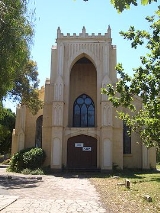
St Peters was named by its association with St Peters Anglican Church, which was consecrated in 1838. St Peters is the third oldest Anglican church in Sydney and has been claimed to be the first church built in Australia using non-convict labour.The first large land grant in the area was made in 1799 to Provost-Marshal Thomas Smyth. His 470 acres (1.9 km²) stretched from the Cooks River to the present Campbell Street. After his death in 1804, the land was acquired by Robert Campbell (1769–1836), a wealthy merchant who built some of the early warehouses along the Sydney Cove waterfront.
Alexander Brodie Spark (1792–1856), was a wealthy merchant who named the suburbs of Tempe
Tempe, New South Wales
Tempe is a suburb in the inner west of Sydney, in the state of New South Wales, Australia. Tempe is located 9 kilometres south of the Sydney central business district in the local government area of Marrickville Council....
after his mansion Tempe House that he built at what is now Wolli Creek
Wolli Creek, New South Wales
For the urban waterway see Wolli CreekWolli Creek is a suburb in southern Sydney, in the state of New South Wales, Australia. It sits beside the Wolli Creek and Cooks River waterways...
and the suburb of St Peters that developed around the church. Barwon Park House was a large residence erected by Spark in 1815 on land leased from Robert Campbell and was demolished in 1953. He sold his property in 1830 but reserved land for the church. St Peters was described in the 1840s as one of the most fashionable and aristocratic suburbs of Sydney.
St Peters was a separate municipality from 1871 to 1949 but now falls under the governance of Marrickville Council
Marrickville Council
Marrickville Council is a Local Government Area situated in the Inner West region of Sydney, Australia.The area is bounded by Leichhardt to the north, the City of Sydney to the east and north-east, the City of Botany Bay to the south-east, Rockdale to the south, Canterbury to the west, and...
. The town hall in Unwins Bridge Road was built in 1927 and now houses the St Peters branch of Marrickville Library and acts as a small community centre. The railway station opened on the 15th October 1884 and the post office opened in October 1851.
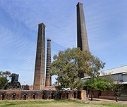
Brickworks
In the 1870s, St Peters was an important brickmaking centre with a large brickworksBrickworks
A brickworks also known as a brick factory, is a factory for the manufacturing of bricks, from clay or shale. Usually a brickworks is located on a clay bedrock often with a quarry for clay on site....
on the site now known as Sydney Park, on the corner of Mitchell Road (now Sydney Park Road) and the Princes Highway
Princes Highway
The Princes Highway extends from Sydney to Port Augusta via the coast through the states of New South Wales, Victoria and South Australia, a distance of 1941 km or 1898 km via the former alignments of the highway ....
, close to St Peters railway station. The brickworks closed after World War II
World War II
World War II, or the Second World War , was a global conflict lasting from 1939 to 1945, involving most of the world's nations—including all of the great powers—eventually forming two opposing military alliances: the Allies and the Axis...
and for most of the Sixties
1960s
The 1960s was the decade that started on January 1, 1960, and ended on December 31, 1969. It was the seventh decade of the 20th century.The 1960s term also refers to an era more often called The Sixties, denoting the complex of inter-related cultural and political trends across the globe...
and Seventies
1970s
File:1970s decade montage.png|From left, clockwise: US President Richard Nixon doing the V for Victory sign after his resignation from office after the Watergate scandal in 1974; Refugees aboard a US naval boat after the Fall of Saigon, leading to the end of the Vietnam War in 1975; The 1973 oil...
the site was used as a rubbish tip with the vast clay pits eventually filled by domestic and commercial refuse. After the tip closed in the 1980s, the area was covered, landscaped and revegetated so that several large artificial hills were created with sweeping views south to Botany Bay and north to the city. Four towering chimneys that carried exhaust from the brick kilns remain standing and have been incorporated into the Sydney Park sitealong with some of the kilns and various pieces of large brickworks machinery.
The brickworks are well known in paleontology
Paleontology
Paleontology "old, ancient", ὄν, ὀντ- "being, creature", and λόγος "speech, thought") is the study of prehistoric life. It includes the study of fossils to determine organisms' evolution and interactions with each other and their environments...
for the discovery of a full, intact skeleton of a Paracyclotosaurus davidi in 1910. The Paracyclotosaurus davidi was a prehistoric amphibian and the only known species to have lived in Australia.
Transport
The Princes HighwayPrinces Highway
The Princes Highway extends from Sydney to Port Augusta via the coast through the states of New South Wales, Victoria and South Australia, a distance of 1941 km or 1898 km via the former alignments of the highway ....
is a major arterial road in southern Sydney
Sydney
Sydney is the most populous city in Australia and the state capital of New South Wales. Sydney is located on Australia's south-east coast of the Tasman Sea. As of June 2010, the greater metropolitan area had an approximate population of 4.6 million people...
. It has its origins in St Peters at the intersection with King Street and Sydney Park Road. Also located at this intersection is St Peters railway station which is served by trains on the Bankstown Line of the City Rail network. City-bound trains arrive approximately every fifteen minutes in peak hour, and take about seven minutes to reach Central station
Central railway station, Sydney
Central Railway Station, the largest railway station in Australia, is at the southern end of the Sydney CBD. It services almost all the lines on the CityRail network, and is the major terminus for interurban and interstate rail services...
. Sydney Buses service St Peters with the Tempe-bound 422 from Circular Quay and the Coogee-bound 370 from Leichhardt.
Commercial area
St Peters has a mixture of residential, commercial and industrial areas. The main shopping strip is located along the Princes Highway, leading into King Street, NewtownNewtown, New South Wales
Newtown, a suburb of Sydney's inner west is located approximately four kilometres south-west of the Sydney central business district, straddling the local government areas of the City of Sydney and Marrickville Council in the state of New South Wales, Australia....
.
Landmarks
- Sydney Park is a large recreation area close to the intersection of the Princes Highway, King Street and Sydney Park Road. Camdenville Oval sits between May Street and the railway line.
- St Peters is the home of the Town and Country Hotel, immortalised in song by Slim DustySlim DustyDavid Gordon "Slim Dusty " Kirkpatrick AO, MBE was an Australian country music singer-songwriter and producer, with a career spanning nearly eight decades. He was known to record songs in the legacy of Australian poets Henry Lawson and Banjo Patterson that represented the Australian Bush...
. The southern Cross Hotel is located on the corner of Princes Highway and Canal Road. - Olympic rings, used to decorate Sydney during the 2000 Olympics, now adorn the entrance to a recycling centre at St Peters.
Churches
St Peters Anglican Church is on the Princes HighwayPrinces Highway
The Princes Highway extends from Sydney to Port Augusta via the coast through the states of New South Wales, Victoria and South Australia, a distance of 1941 km or 1898 km via the former alignments of the highway ....
. It was designed by Thomas Bird and built in 1838-39. In 1875, alterations were carried out under the supervision of Edmund Blacket
Edmund Blacket
Edmund Thomas Blacket was an Australian architect, best known for his designs for the University of Sydney, St. Andrew's Cathedral, Sydney and St...
. The church is now listed on the Register of the National Estate
Register of the National Estate
The Register of the National Estate is a listing of natural and cultural heritage places in Australia. The listing was initially compiled between 1976 and 2003 by the Australian Heritage Commission. The register is now maintained by the Australian Heritage Council...
. In 2009, the church was given a grant of $30,000 from the State Government, for carrying out much-needed renovations. The grant was aimed at repairing cracked walls and sealing windows. Pastor Shane Rogerson said the building was "ill-fated from the beginning" because it was built on clay-based soil, which meant it will always have problems with cracking.