

Hurlstone Park, New South Wales
Encyclopedia
Hurlstone Park is a suburb in the inner-west
of Sydney, in the state of New South Wales, Australia. Hurlstone Park is located 10 kilometres south-west of the Sydney central business district
and is mostly in the local government area of the City of Canterbury
, and partly in the Municipality of Ashfield
. The suburb is bounded by: the Cooks River
to the south, Garnet Street to the east, New Canterbury Road to the north, Canterbury Road to the north-west, and Church Street to the west.
refused to open a post office called Fernhill, a 1910 referendum chose the name 'Hurlstone', after the nearby Hurlstone College. John Kinloch founded the college in 1878, on the site of present-day Trinity Grammar School and named it after his mother's maiden name, which was Helen Hurlstone. The college moved to a new site, now known as Hurlstone Agricultural High School
. The 'Park' was added at the request of the Railways Department, to avoid confusion with the New South Wales town of Hillston
.
station (located 8.8 km from Central station
) on the Bankstown line. Sydney Buses provide the following services in Hurlstone Park: the 444, 445, 428, and L28 routes which run along the Canterbury Road and New Canterbury Road boundary; and the 418 and 406 routes which pass through the suburb (along Crinan Street and intersecting with the railway station).
The rest of the commercially-used land in Hurlstone Park is made up of various shops, ranging from fast food outlets and milk bars to a couple of petrol stations. Hurlstone Park also has three childcare centres.
or townhouse
s.
 Hurlstone Park includes the following parks and reserves:
The suburb contains the following religious establishments:
Inner West (Sydney)
The Inner West is a general term which is used to describe the metropolitan area directly to the west of the Sydney central business district, New South Wales, Australia...
of Sydney, in the state of New South Wales, Australia. Hurlstone Park is located 10 kilometres south-west of the Sydney central business district
Sydney central business district
The Sydney central business district is the main commercial centre of Sydney, New South Wales, Australia. It extends southwards for about 3 kilometres from Sydney Cove, the point of first European settlement. Its north–south axis runs from Circular Quay in the north to Central railway station in...
and is mostly in the local government area of the City of Canterbury
City of Canterbury, New South Wales
The City of Canterbury, previously the Municipality of Canterbury, is a Local Government Area in Sydney, New South Wales, Australia. It lies southwest of the central business district and forms part of the Greater Sydney metropolitan area....
, and partly in the Municipality of Ashfield
Municipality of Ashfield
The Municipality of Ashfield is a Local Government Area of Sydney, New South Wales, Australia. It lies approximately 10 kilometres west of the central business district.- Demographics :According to the , there:...
. The suburb is bounded by: the Cooks River
Cooks River
The Cooks River is a 23 kilometre long urban waterway of south-western Sydney, New South Wales, Australia emptying into Botany Bay. The course of the river has been altered to accommodate various developments along its shore...
to the south, Garnet Street to the east, New Canterbury Road to the north, Canterbury Road to the north-west, and Church Street to the west.
History
Previously known as 'Wattle Hill' and then 'Fernhill'. After the Postmaster-General's DepartmentPostmaster-General's Department
The Postmaster-General's Department was created at Federation in 1901 to control all postal services within Australia. Its minister was the Postmaster-General. In mid-1975 it was disaggregated into the Australian Telecommunications Commission and the Australian Postal Commission...
refused to open a post office called Fernhill, a 1910 referendum chose the name 'Hurlstone', after the nearby Hurlstone College. John Kinloch founded the college in 1878, on the site of present-day Trinity Grammar School and named it after his mother's maiden name, which was Helen Hurlstone. The college moved to a new site, now known as Hurlstone Agricultural High School
Hurlstone Agricultural High School
Hurlstone Agricultural High School is an agricultural and selective, co-educational, public high school, located in Glenfield, a south-western suburb of Sydney, New South Wales, Australia...
. The 'Park' was added at the request of the Railways Department, to avoid confusion with the New South Wales town of Hillston
Hillston, New South Wales
Hillston is a township in western New South Wales, Australia, in Carrathool Shire, built on the banks of the Lachlan River. It was founded in 1863 and at the 2006 census had a population of 1,054.-History:...
.
Transport
Hurlstone Park railway station is a CityRailCityRail
CityRail is an operating brand of RailCorp, a corporation owned by the state government of New South Wales, Australia. It is responsible for providing commuter rail services, and some coach services, in and around Sydney, Newcastle and Wollongong, the three largest cities of New South Wales. It is...
station (located 8.8 km from Central station
Central railway station, Sydney
Central Railway Station, the largest railway station in Australia, is at the southern end of the Sydney CBD. It services almost all the lines on the CityRail network, and is the major terminus for interurban and interstate rail services...
) on the Bankstown line. Sydney Buses provide the following services in Hurlstone Park: the 444, 445, 428, and L28 routes which run along the Canterbury Road and New Canterbury Road boundary; and the 418 and 406 routes which pass through the suburb (along Crinan Street and intersecting with the railway station).
Commercial area
There is a group of shops around Hurlstone Park Station: along Crinan Street and Floss Street. There are also commercial areas along Canterbury Road and New Canterbury Road.The rest of the commercially-used land in Hurlstone Park is made up of various shops, ranging from fast food outlets and milk bars to a couple of petrol stations. Hurlstone Park also has three childcare centres.
Pubs and clubs
Hurlstone Park contains the following clubs and pubs:- The Canterbury Hurlstone Park RSL club, located on the corner of Canterbury Road and Crinan Street, is an entertainment venue that attracts many Australian and international performers. The club also contains a war memorial chapel.
- The Hurlstone Park Bowling & Recreation Club. Located in Marcia street.
- The Hurlstone Park Hotel, located on the corner of New Canterbury road and Duntroon street, is also known as "Grumpy's".
- The Sydney Olympic Sporting Club was located at 64 Tennent parade. It was demolished in October 2010.
Houses
Hurlstone Park is a predominantly residential suburb. The majority of the residential land in Hurlstone Park is single dwelling housing ie.detached houses. Only a small proportion of the residential land is multiple dwelling housing such as unitsApartment
An apartment or flat is a self-contained housing unit that occupies only part of a building...
or townhouse
Townhouse
A townhouse is the term historically used in the United Kingdom, Ireland and in many other countries to describe a residence of a peer or member of the aristocracy in the capital or major city. Most such figures owned one or more country houses in which they lived for much of the year...
s.
Parks and reserves
- Ewen Park. Located along the Cooks river (in the middle of the southern end of the suburb). It is the largest individual park in the suburb and contains two playing fields that are home to the Hurlstone Park Wanderers soccer club. The fields in Ewen park are also used for cricket in summer.
- Warwick Reserve. Located at the intersection of Church and Canberra streets in the south-west corner of the suburb.
- Euston Reserve. Located at the intersection of Euston and Floss streets, the reserve contains a war memorial.
- Sawyer Reserve. Located at the intersection of Dunstaffenage street and Foord avenue.
- Hurlstone Memorial Reserve. A small reserve located next to the Hurlstone Park Bowling Club (along Crinan Street).
- Burnett Street Reserve. The reserve splits Burnett street into two sections.
- Dick Poole Reserve. A small reserve that joins the end of Barre street with the point where Wallace avenue and Wallace lane meet.
- Moser Reserve. A small reserve on the south side of the railway line in Keir Avenue.
- Fernhill Street Reserve. A small reserve near the northern end of Fernhill street (with lane access to Barton avenue).
- A small reserve at the intersection of Garnet street and Tennent parade (in the south-east corner of the suburb). Located next to the 14th hole of Marrickville golf course, the unnamed reserve contains a cricket practice net and a practice goal post (for soccer and rugby).
- A small reserve on the corner of Crinan and Melford streets. The unnamed reserve is a small grassed area that was opened to the public following the demolition of a single house.
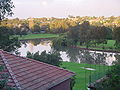
- A green belt along the entire southern border of the suburb. The belt follows the Cooks River and encompasses Ewen park. The Botany Bay cycle way extends for 23 km (with Hurlstone Park being approximately one third of the way from Botany Bay to Ryde). The western part of the belt contains a constructed rectangular inlet of water named Boat Harbour. The eastern part of the belt constitutes part of the 13th and 14th holes of Marrickville Golf Course. There are three foot bridges that cross the Cooks River to the south of the belt: One bridge crosses from the end of Sugar House Road (off Hutton Street), a second bridge crosses from the end of Foord Avenue, and the third bridge crosses near the intersection of Tennent Parade and Burnett Street.
Churches and religion
According to the 2001 census, the main religious affiliations in Hurlstone Park were: Catholic (35.7%), Orthodox (15.3%), No Religion (13.1%), Anglican (8.3%), Buddhism (4.2%), "other" (23.4%).The suburb contains the following religious establishments:
- St Stephen Greek Orthodox Archdiocese of Australia. Located at 650 New Canterbury road.
- Hurlstone Park Uniting Church (Dulwich Hill parish). Located at 8 Melford street, the church provides services in English and Tongan.
- Sydney Revival Fellowship Inc. Located at 83 Dunstaffenage St.
- Siddha YogaSiddha YogaSiddha Yoga is a spiritual path based on the Hindu spiritual traditions of Vedanta and Kashmir Shaivism. The Siddha Yoga path was founded by Swami Muktananda Paramahamsa . The present spiritual head of the Siddha Yoga path is Gurumayi Chidvilasananda...
AshramAshramTraditionally, an ashram is a spiritual hermitage. Additionally, today the term ashram often denotes a locus of Indian cultural activity such as yoga, music study or religious instruction, the moral equivalent of a studio or dojo....
. Located at 50 Garnet Street. - Hurlstone Park Vietnamese Baptist Church. Technically, the location of the church (corner of Queen and Griffiths streets) is in the neighbouring suburb of Ashfield (but only by 180 metres).