

Dulwich Hill, New South Wales
Encyclopedia
Dulwich Hill is a residential suburb
in the Inner West
of Sydney
, in the state of New South Wales
, Australia
. Dulwich Hill is located 9 kilometres south-west of the Sydney central business district
, in the local government area of Marrickville Council
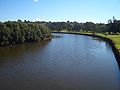
. Dulwich Hill stretches south to the shore of the Cooks River
.
in London
. The name Dulwich Hill appears in Sand's Directory of 1892. It had been known by several different names prior to this. Following European settlement, it was called Petersham Hill. It later took the name Wardell's Bush, a reference to Dr Robert Wardell
, one of the area's early landowners. Other names the area was given were South Petersham and Fern Hill.
The area became part of Sydney's expanding tram network in 1889 and, like many suburbs in the inner-west
, experienced rapid growth in the early twentieth century. As a consequence, the suburb has a large number of examples of Australian Federation architecture
. It also features examples of Edwardian, Gothic
and Italianate architecture. The tramway ran up until 1957.
Listed on the Register of the National Estate is the former public school in Seaview Street, which now operates as the Dulwich Hill High School of Visual Arts and Design. The building was designed by W.E.Kemp in the Romanesque style
and built circa 1892. Situated in the same street is the Dulwich Hill Library, a converted cottage in the Victorian Gothic
style.
, but was never chartered a town hall or police station
(the nearest is Marrickville Local Area Command).
: Dulwich Hill Public School in Kintore Street, St Marouns College in Wardell Road and St Paul of the Cross, a Catholic school
in New Canterbury Road, as well as one secondary school, Dulwich High School of Visual Arts & Design in Seaview Street. Dulwich High School was the first Visual Arts School in Australia.
Notable graduates of the high school include former Parramatta rugby league
coach Terry Fearnley
, tennis player Phil Dent
and opera singer Yvonne Minton
, while former rugby league referee Jack Danzey taught there.
ran to Dulwich Hill and the Cooks River
from Circular Quay. The line to Dulwich Hill branched from the Cooks River line at Newtown, turning off King Street into Enmore Road, travelling through Marrickville and Dulwich Hill, via Victoria and Marrickville Roads. A tram tuning loop was provided at the Canterbury Road terminus.
to the area comprises a station on the electric metropolitan railway and several routes serviced by natural gas
and diesel Government buses. A light rail route is under planning.
Dulwich Hill railway station is located on Wardell Road, in the southern part of the suburb. The station is serviced by the Bankstown railway line of the CityRail
network which provides reasonably frequent services to the Sydney CBD
and south-western suburbs. Travelling west, residents can visit Bankstown
and beyond to Liverpool
and Lidcombe
(a junction servicing several lines).
The 426, 428, 418, 444/445 and 412 bus routes run through Dulwich Hill. The suburb's main bus route, 426, starts at the corner of Marrickville and New Canterbury Roads and runs along Marrickville Road towards Marrickville. The 428 service runs from Canterbury
Station along New Canterbury Road towards Petersham. Both these services go to the Sydney CBD via Newtown
, terminating at Circular Quay. The 418 between Tempe and Burwood via Ashfield follows the same route as 426 between Marrickville and Dulwich Hill shops, before swinging on to New Caterbury Rd, and then south to Hurlstone Park Station. The 444/445 routes run from Campsie
Station to Balmain
via Leichhardt
, following the same route as the 428 through Dulwich Hill. The 412 runs from Campsie to King Street Wharf
in the city. It comes up Wardell Road, passing Dulwich Hill railway station, before running along the south side of the railway and proceeding up Livingstone Road towards Marrickville and Petersham.
The current light rail service
that runs from Central Station to Lilyfield is now being extended to Dulwich Hill, making use of a disused heavy rail freight line. There will be four new stations located in Dulwich Hill. These are - Dulwich Hill Interchange
(adjacent to the railway station), Dulwich Grove
(between New Canterbury Road and Hercules Street with access being gained from both streets), Arlington
(adjacent to Johnson Park near Constitution Road) and Waratah Mills (near Davis Street). Access to the city will be quicker by train, but the light rail may be used for some cross-regional journeys. The service will also interchange with Lewisham railway station on the Inner West Line.
, state
and local
governments. At the federal level, it is in the electoral division of Grayndler
, currently held by Anthony Albanese
, of the Australian Labor Party
(ALP), who was last re-elected in the 2007 General Election and has been named as a member of the Cabinet in the Rudd Government as the Minister for Infrastructure, Transport, Regional Development and Local Government. The seat of Grayndler has been held continuously by the ALP since it was proclaimed in 1949.
 At the state level, Dulwich Hill is predominantly in the Electoral district of Marrickville
, held by the ALP's
Carmel Tebbutt
, who was formerly a senior minister in the NSW Government
but moved to the backbench after the 2007 election to spend more time with her young son. Residents on the western side of Dulwich Hill are in the Electoral district of Canterbury
, held by Linda Burney
, also an ALP member, and currently Minister for Fair Trading. Previously, Dulwich Hill had been part of the Electoral district of Ashfield
but that was abolished in 1999.
At the local level, Dulwich Hill is in the west ward of Marrickville Council
, represented by three councillors: Marika Kontellis, a member of the Australian Greens
, Dimitrios Thanos, a local dentist and independent councillor first elected in 1999, and Emanuel Tsardoulias from the Australian Labor Party
.
soccer club, which plays in the NSW Super League, the second tier of senior soccer in Sydney, and also the Stanmore Hawks
soccer club which plays in the NSW State League Division One, the third tier.
with many examples of Federation architecture
. The streets are wider than many inner-city
suburbs and houses are bigger than some older, neighbouring suburbs such as Petersham. However, the area is also zoned for medium-density housing
, with several blocks of flats having been built in the last forty years.
.
Suburb
The word suburb mostly refers to a residential area, either existing as part of a city or as a separate residential community within commuting distance of a city . Some suburbs have a degree of administrative autonomy, and most have lower population density than inner city neighborhoods...
in the Inner West
Inner West (Sydney)
The Inner West is a general term which is used to describe the metropolitan area directly to the west of the Sydney central business district, New South Wales, Australia...
of Sydney
Sydney
Sydney is the most populous city in Australia and the state capital of New South Wales. Sydney is located on Australia's south-east coast of the Tasman Sea. As of June 2010, the greater metropolitan area had an approximate population of 4.6 million people...
, in the state of New South Wales
New South Wales
New South Wales is a state of :Australia, located in the east of the country. It is bordered by Queensland, Victoria and South Australia to the north, south and west respectively. To the east, the state is bordered by the Tasman Sea, which forms part of the Pacific Ocean. New South Wales...
, Australia
Australia
Australia , officially the Commonwealth of Australia, is a country in the Southern Hemisphere comprising the mainland of the Australian continent, the island of Tasmania, and numerous smaller islands in the Indian and Pacific Oceans. It is the world's sixth-largest country by total area...
. Dulwich Hill is located 9 kilometres south-west of the Sydney central business district
Sydney central business district
The Sydney central business district is the main commercial centre of Sydney, New South Wales, Australia. It extends southwards for about 3 kilometres from Sydney Cove, the point of first European settlement. Its north–south axis runs from Circular Quay in the north to Central railway station in...
, in the local government area of Marrickville Council
Marrickville Council
Marrickville Council is a Local Government Area situated in the Inner West region of Sydney, Australia.The area is bounded by Leichhardt to the north, the City of Sydney to the east and north-east, the City of Botany Bay to the south-east, Rockdale to the south, Canterbury to the west, and...
. Dulwich Hill stretches south to the shore of the Cooks River
Cooks River
The Cooks River is a 23 kilometre long urban waterway of south-western Sydney, New South Wales, Australia emptying into Botany Bay. The course of the river has been altered to accommodate various developments along its shore...
.
History
The suburb takes its name from the area of DulwichDulwich
Dulwich is an area of South London, England. The settlement is mostly in the London Borough of Southwark with parts in the London Borough of Lambeth...
in London
London
London is the capital city of :England and the :United Kingdom, the largest metropolitan area in the United Kingdom, and the largest urban zone in the European Union by most measures. Located on the River Thames, London has been a major settlement for two millennia, its history going back to its...
. The name Dulwich Hill appears in Sand's Directory of 1892. It had been known by several different names prior to this. Following European settlement, it was called Petersham Hill. It later took the name Wardell's Bush, a reference to Dr Robert Wardell
Robert Wardell
Robert Wardell was an English-born Australian barrister and newspaper editor.-Early life:Wardell was born in England and educated at Trinity College, Cambridge, where he matriculated 1810, gained his LL.B. in 1817 and a LL.D. in 1823. Wardell was editor and proprietor of the Statesman, a London...
, one of the area's early landowners. Other names the area was given were South Petersham and Fern Hill.
The area became part of Sydney's expanding tram network in 1889 and, like many suburbs in the inner-west
Inner West (Sydney)
The Inner West is a general term which is used to describe the metropolitan area directly to the west of the Sydney central business district, New South Wales, Australia...
, experienced rapid growth in the early twentieth century. As a consequence, the suburb has a large number of examples of Australian Federation architecture
Federation architecture
Federation architecture refers to the architectural style in Australia, which was prevalent from around 1890 to 1920. The period refers to the Federation of Australia on 1 January 1901, when the Australian colonies collectively became the Commonwealth of Australia...
. It also features examples of Edwardian, Gothic
Gothic architecture
Gothic architecture is a style of architecture that flourished during the high and late medieval period. It evolved from Romanesque architecture and was succeeded by Renaissance architecture....
and Italianate architecture. The tramway ran up until 1957.
Listed on the Register of the National Estate is the former public school in Seaview Street, which now operates as the Dulwich Hill High School of Visual Arts and Design. The building was designed by W.E.Kemp in the Romanesque style
Romanesque architecture
Romanesque architecture is an architectural style of Medieval Europe characterised by semi-circular arches. There is no consensus for the beginning date of the Romanesque architecture, with proposals ranging from the 6th to the 10th century. It developed in the 12th century into the Gothic style,...
and built circa 1892. Situated in the same street is the Dulwich Hill Library, a converted cottage in the Victorian Gothic
Gothic Revival architecture
The Gothic Revival is an architectural movement that began in the 1740s in England...
style.
Commercial area
Dulwich Hill features two shopping areas, a small number of shops on Wardell Road near Dulwich Hill railway station and the main shopping area around the northern end of Marrickville Road and its intersection with New Canterbury Road. The Marrickville Road shopping area centred on the former tram line (now replaced by buses), and continues onto New Canterbury Road. In the 1990s many shops were vacant, but in recent years most shops have tenants with thriving businesses. Cafés and restaurants have become popular as the suburb becomes gentrified. Marrickville Council upgraded the shopping strip in the early 2000s, enhancing the look and character of the area. Dulwich Hill has a library (a branch of Marrickville Library) and a post officeAustralia Post
Australia Post is the trading name of the Australian Government-owned Australian Postal Corporation .-History:...
, but was never chartered a town hall or police station
New South Wales Police
The New South Wales Police Force is the primary law enforcement agency in the State of New South Wales, Australia. It is an agency of the Government of New South Wales within the New South Wales Ministry for Police...
(the nearest is Marrickville Local Area Command).
Education
Dulwich Hill contains three primary schoolsEducation in Australia
Education in Australia is primarily the responsibility of the states and territories. Each state or territory government provides funding and regulates the public and private schools within its governing area. The federal government helps fund the public universities, but is not involved in setting...
: Dulwich Hill Public School in Kintore Street, St Marouns College in Wardell Road and St Paul of the Cross, a Catholic school
Catholic school
Catholic schools are maintained parochial schools or education ministries of the Catholic Church. the Church operates the world's largest non-governmental school system...
in New Canterbury Road, as well as one secondary school, Dulwich High School of Visual Arts & Design in Seaview Street. Dulwich High School was the first Visual Arts School in Australia.
Notable graduates of the high school include former Parramatta rugby league
Rugby league
Rugby league football, usually called rugby league, is a full contact sport played by two teams of thirteen players on a rectangular grass field. One of the two codes of rugby football, it originated in England in 1895 by a split from Rugby Football Union over paying players...
coach Terry Fearnley
Terry Fearnley
Terry Fearnley is an Australian former rugby league footballer and later coach. He was a long serving member of the NSWRFL's Eastern Suburbs team & , playing 144 matches for them at a bleak period in that club's existence. Injury kept him out of the 1960 grand final, one of the few successful...
, tennis player Phil Dent
Phil Dent
Phillip "Phil" Dent, born on 14 February 1950, in Sydney, Australia, is a former professional tennis player. Dent's high water mark as a pro singles player was reaching the Australian Open final in 1974, which he lost to Jimmy Connors 7–6, 6–4, 4–6, 6–3...
and opera singer Yvonne Minton
Yvonne Minton
Yvonne Fay Minton CBE is an Australian opera singer. She is variously billed as a soprano, mezzo-soprano or contralto.Yvonne Minton was born in Sydney, New South Wales. She studied voice on a scholarship at the New South Wales Conservatorium of Music. She won the National Eisteddfod in Canberra,...
, while former rugby league referee Jack Danzey taught there.
Tram history
Until the late 1950s, when the local tramway system was closed, electric tramsTrams in Sydney
The Sydney tramway network once served Sydney, the capital city of New South Wales, Australia. In its heyday, it was the largest in Australia, the second largest in the Commonwealth , and one of the largest in the world. It was extremely intensively worked, with about 1,600 cars in service at any...
ran to Dulwich Hill and the Cooks River
Cooks River
The Cooks River is a 23 kilometre long urban waterway of south-western Sydney, New South Wales, Australia emptying into Botany Bay. The course of the river has been altered to accommodate various developments along its shore...
from Circular Quay. The line to Dulwich Hill branched from the Cooks River line at Newtown, turning off King Street into Enmore Road, travelling through Marrickville and Dulwich Hill, via Victoria and Marrickville Roads. A tram tuning loop was provided at the Canterbury Road terminus.
Modern transport
Modern public transportPublic transport
Public transport is a shared passenger transportation service which is available for use by the general public, as distinct from modes such as taxicab, car pooling or hired buses which are not shared by strangers without private arrangement.Public transport modes include buses, trolleybuses, trams...
to the area comprises a station on the electric metropolitan railway and several routes serviced by natural gas
Natural gas
Natural gas is a naturally occurring gas mixture consisting primarily of methane, typically with 0–20% higher hydrocarbons . It is found associated with other hydrocarbon fuel, in coal beds, as methane clathrates, and is an important fuel source and a major feedstock for fertilizers.Most natural...
and diesel Government buses. A light rail route is under planning.
Dulwich Hill railway station is located on Wardell Road, in the southern part of the suburb. The station is serviced by the Bankstown railway line of the CityRail
CityRail
CityRail is an operating brand of RailCorp, a corporation owned by the state government of New South Wales, Australia. It is responsible for providing commuter rail services, and some coach services, in and around Sydney, Newcastle and Wollongong, the three largest cities of New South Wales. It is...
network which provides reasonably frequent services to the Sydney CBD
Sydney central business district
The Sydney central business district is the main commercial centre of Sydney, New South Wales, Australia. It extends southwards for about 3 kilometres from Sydney Cove, the point of first European settlement. Its north–south axis runs from Circular Quay in the north to Central railway station in...
and south-western suburbs. Travelling west, residents can visit Bankstown
Bankstown, New South Wales
Bankstown is a suburb of south-western Sydney, in the state of New South Wales, Australia. Bankstown is located 20 kilometres south-west of the Sydney central business district and is the administrative centre of the local government area of the City of Bankstown.-History:Prior to European...
and beyond to Liverpool
Liverpool, New South Wales
Liverpool is a suburb in south-western Sydney, in the state of New South Wales, Australia. Liverpool is located 32 km south-west of the Sydney central business district, and is the administrative centre of the local government area of the City of Liverpool...
and Lidcombe
Lidcombe, New South Wales
Lidcombe is a suburb in western Sydney, in the state of New South Wales Australia. Lidcombe is located 14 kilometres west of the Sydney central business district, in the local government area of Auburn Council....
(a junction servicing several lines).
The 426, 428, 418, 444/445 and 412 bus routes run through Dulwich Hill. The suburb's main bus route, 426, starts at the corner of Marrickville and New Canterbury Roads and runs along Marrickville Road towards Marrickville. The 428 service runs from Canterbury
Canterbury, New South Wales
-Commercial area:Canterbury has a mixture of residential, commercial and industrial developments. Commercial developments are mostly situated on Canterbury Road and surrounding streets...
Station along New Canterbury Road towards Petersham. Both these services go to the Sydney CBD via Newtown
Newtown, New South Wales
Newtown, a suburb of Sydney's inner west is located approximately four kilometres south-west of the Sydney central business district, straddling the local government areas of the City of Sydney and Marrickville Council in the state of New South Wales, Australia....
, terminating at Circular Quay. The 418 between Tempe and Burwood via Ashfield follows the same route as 426 between Marrickville and Dulwich Hill shops, before swinging on to New Caterbury Rd, and then south to Hurlstone Park Station. The 444/445 routes run from Campsie
Campsie, New South Wales
Campsie is a suburb in south-western Sydney, in the state of New South Wales, Australia. Campsie is located 13 kilometres south-west of the Sydney central business district, on the southern bank of the Cooks River. Campsie is the commercial and administrative centre of the City of...
Station to Balmain
Balmain, New South Wales
Balmain is a suburb in the inner-west of Sydney, in the state of New South Wales, Australia. Balmain is located slightly west of the Sydney central business district, in the local government area of the Municipality of Leichhardt....
via Leichhardt
Leichhardt, New South Wales
Leichhardt is a suburb in the inner-west of Sydney in New South Wales, Australia. Leichhardt is located 5 kilometres west of the Sydney central business district and is the administrative centre for the local government area of the Municipality of Leichhardt...
, following the same route as the 428 through Dulwich Hill. The 412 runs from Campsie to King Street Wharf
King Street Wharf
King Street Wharf covering approximately five hectares, is a former maritime industrial area on the eastern shore of Darling Harbour, an inlet of Sydney Harbour, Australia, that has been redeveloped into a mixed use tourism, commercial, residential and maritime development as part of the extensive...
in the city. It comes up Wardell Road, passing Dulwich Hill railway station, before running along the south side of the railway and proceeding up Livingstone Road towards Marrickville and Petersham.
The current light rail service
Metro Light Rail
The Metro Light Rail is the only currently operating light rail line in Sydney. The line opened on 31 August 1997, mostly along the route of an unused goods railway line, to serve the redeveloped inner-city areas of Darling Harbour, Ultimo and Pyrmont, and was extended in 2000 to serve some of...
that runs from Central Station to Lilyfield is now being extended to Dulwich Hill, making use of a disused heavy rail freight line. There will be four new stations located in Dulwich Hill. These are - Dulwich Hill Interchange
Dulwich Hill Interchange MLR station
Dulwich Hill Interchange MLR station is a planned light rail stop located in the southern part of the suburb of Dulwich Hill on the Metro Light Rail line in Sydney, New South Wales, Australia. The stop is planned for completion in 2012...
(adjacent to the railway station), Dulwich Grove
Dulwich Grove MLR station
Dulwich Grove MLR station is a planned light rail stop on the Metro Light Rail line in Sydney, New South Wales, Australia serving the suburb of Dulwich Hill. The stop is located in a cutting between New Canterbury Road and Hercules Street with access to the stop available from both streets. It is...
(between New Canterbury Road and Hercules Street with access being gained from both streets), Arlington
Arlington MLR station
Arlington MLR station is a planned light rail stop on the Metro Light Rail line in Sydney, New South Wales, Australia located in the suburb of Dulwich Hill - adjacent to Constitution Road and Johnson Park. The stop is planned for completion in 2012...
(adjacent to Johnson Park near Constitution Road) and Waratah Mills (near Davis Street). Access to the city will be quicker by train, but the light rail may be used for some cross-regional journeys. The service will also interchange with Lewisham railway station on the Inner West Line.
Demographics
In the 20th Century, much of Dulwich Hill was shaped by immigrants from Greece (particularly closer to Marrickville) and Portugal (particularly closer to Petersham). More recent arrivals include those from Pacific Island nations, China and Vietnam. Today, fewer migrants (and their descendants) live and own businesses in Dulwich Hill. More families and young urban professionals have been attracted to the suburb by its proximity to the Sydney CBD and multicultural lifestyle.Governance
Residents of Dulwich Hill elect representatives to federalFederation
A federation , also known as a federal state, is a type of sovereign state characterized by a union of partially self-governing states or regions united by a central government...
, state
States and territories of Australia
The Commonwealth of Australia is a union of six states and various territories. The Australian mainland is made up of five states and three territories, with the sixth state of Tasmania being made up of islands. In addition there are six island territories, known as external territories, and a...
and local
Local Government Areas of New South Wales
The local government areas of New South Wales, Australia have been subject to periodic bouts of restructuring and rationalisation by the State Government, involving voluntary and involuntary amalgamation of areas...
governments. At the federal level, it is in the electoral division of Grayndler
Division of Grayndler
The Division of Grayndler is an Australian Electoral Division in inner Metropolitan Sydney, New South Wales. It is one of Australia's smallest electorates, located in the inner-southern Sydney metropolitan area, including parts of the inner-west...
, currently held by Anthony Albanese
Anthony Albanese
Anthony Norman Albanese , Australian politician, who serves as Leader of the House of Representatives and Minister for Infrastructure and Transport in the Gillard Ministry...
, of the Australian Labor Party
Australian Labor Party
The Australian Labor Party is an Australian political party. It has been the governing party of the Commonwealth of Australia since the 2007 federal election. Julia Gillard is the party's federal parliamentary leader and Prime Minister of Australia...
(ALP), who was last re-elected in the 2007 General Election and has been named as a member of the Cabinet in the Rudd Government as the Minister for Infrastructure, Transport, Regional Development and Local Government. The seat of Grayndler has been held continuously by the ALP since it was proclaimed in 1949.
Electoral district of Marrickville
Marrickville is an electoral district of the Legislative Assembly in the Australian state of New South Wales. It is a 13.47 km² urban electorate in Sydney's inner west, centred on the suburb of Marrickville from which it takes its name...
, held by the ALP's
Australian Labor Party
The Australian Labor Party is an Australian political party. It has been the governing party of the Commonwealth of Australia since the 2007 federal election. Julia Gillard is the party's federal parliamentary leader and Prime Minister of Australia...
Carmel Tebbutt
Carmel Tebbutt
Carmel Mary Tebbutt is an Australian politician. She is the Australian Labor Party Member for Marrickville in the New South Wales Legislative Assembly and was Deputy Premier of New South Wales from 2008 to 2011. She was also Minister for Health in the Keneally Government...
, who was formerly a senior minister in the NSW Government
Government of New South Wales
The form of the Government of New South Wales is prescribed in its Constitution, which dates from 1856, although it has been amended many times since then...
but moved to the backbench after the 2007 election to spend more time with her young son. Residents on the western side of Dulwich Hill are in the Electoral district of Canterbury
Electoral district of Canterbury
Canterbury is an electoral district of the Legislative Assembly in the Australian state of New South Wales. It is represented by Linda Burney of the Australian Labor Party.-History:...
, held by Linda Burney
Linda Burney
The Hon. Linda Jean Burney MP, an Australian politician, is a member of the New South Wales Legislative Assembly representing Canterbury for the Australian Labor Party since 2003...
, also an ALP member, and currently Minister for Fair Trading. Previously, Dulwich Hill had been part of the Electoral district of Ashfield
Electoral district of Ashfield
Ashfield was an electoral district of the Legislative Assembly in the Australian state of New South Wales, first created in 1894 with the abolition of multi-member electoral districts from part of Canterbury, and named after the Sydney suburb of Ashfield. It was abolished in 1920, with the...
but that was abolished in 1999.
At the local level, Dulwich Hill is in the west ward of Marrickville Council
Marrickville Council
Marrickville Council is a Local Government Area situated in the Inner West region of Sydney, Australia.The area is bounded by Leichhardt to the north, the City of Sydney to the east and north-east, the City of Botany Bay to the south-east, Rockdale to the south, Canterbury to the west, and...
, represented by three councillors: Marika Kontellis, a member of the Australian Greens
Australian Greens
The Australian Greens, commonly known as The Greens, is an Australian green political party.The party was formed in 1992; however, its origins can be traced to the early environmental movement in Australia and the formation of the United Tasmania Group , the first Green party in the world, which...
, Dimitrios Thanos, a local dentist and independent councillor first elected in 1999, and Emanuel Tsardoulias from the Australian Labor Party
Australian Labor Party
The Australian Labor Party is an Australian political party. It has been the governing party of the Commonwealth of Australia since the 2007 federal election. Julia Gillard is the party's federal parliamentary leader and Prime Minister of Australia...
.
Sport and recreation
Arlington Recreation Ground in Williams Parade is home to the Dulwich Hill FCDulwich Hill FC
Dulwich Hill FC are an football team located in the Inner West suburb of Dulwich Hill in Sydney. They currently play in the NSW Super League, the second tier of football in New South Wales, and third tier in Australia.-History:...
soccer club, which plays in the NSW Super League, the second tier of senior soccer in Sydney, and also the Stanmore Hawks
Stanmore Hawks
Stanmore Hawks is an Australian Football Club based in Stanmore, New South Wales. The Club was founded by Greek-Cypriot Migrants in 1978 and under originally the name Cypriot Youth Club....
soccer club which plays in the NSW State League Division One, the third tier.
Houses
Dulwich Hill is an established residential areaResidential area
A residential area is a land use in which housing predominates, as opposed to industrial and commercial areas.Housing may vary significantly between, and through, residential areas. These include single family housing, multi-family residential, or mobile homes. Zoning for residential use may permit...
with many examples of Federation architecture
Federation architecture
Federation architecture refers to the architectural style in Australia, which was prevalent from around 1890 to 1920. The period refers to the Federation of Australia on 1 January 1901, when the Australian colonies collectively became the Commonwealth of Australia...
. The streets are wider than many inner-city
Inner city
The inner city is the central area of a major city or metropolis. In the United States, Canada, United Kingdom and Ireland, the term is often applied to the lower-income residential districts in the city centre and nearby areas...
suburbs and houses are bigger than some older, neighbouring suburbs such as Petersham. However, the area is also zoned for medium-density housing
Medium-density housing
Medium density housing is a term used in Australia to describe residential developments that are at higher densities than standard low-density, suburban subdivisions, but not so high that they might be regarded as high density housing. The density of standard suburban residential areas has...
, with several blocks of flats having been built in the last forty years.
Churches
The area is served by several religious organisations, including Anglican, Catholic and Greek Orthodox churchesEastern Orthodox Church
The Orthodox Church, officially called the Orthodox Catholic Church and commonly referred to as the Eastern Orthodox Church, is the second largest Christian denomination in the world, with an estimated 300 million adherents mainly in the countries of Belarus, Bulgaria, Cyprus, Georgia, Greece,...
.