

Brighton-Le-Sands, New South Wales
Encyclopedia
Brighton-Le-Sands is a suburb
in southern
Sydney
, in the state of New South Wales
, Australia
. Brighton-Le-Sands is located 13 kilometres south of the Sydney central business district
, on the western shore of Botany Bay
. Brighton-Le-Sands is in the local government area of the City of Rockdale
and is part of the St George
area.
Lady Robinsons Beach and Cook Park run along the eastern border of Brighton-Le-Sands, on Botany Bay
. The beach is also commonly referred to as Brighton Beach. Brighton-Le-Sands features a mixture of low density houses, medium density flats, high rise apartments, retail, cafés and restaurants. The Grand Parade runs along the foreshore and intersects with Bay Street, at the commercial centre. The higher density developments are located along these streets.
and Georges River
was originally known as Seven Mile Beach. It was changed to Lady Robinson’s Beach in 1874 to honour Governor Sir Hercules Robinson’s wife. Cook Park is named after Samuel Cook who advocated it as a public pleasure area.
New Brighton was the original name used by tramway pioneer Thomas Saywell, after the famous seaside resort Brighton
in England
. Land acquisitions began in the 1840s but no significant development occurred until the railway opened to Hurstville, via Rockdale in 1884. In 1885 Thomas Saywell constructed a tramway
from Rockdale to Lady Robinson Beach, along Bay Street. He was given a 30 year lease on the line. He also financed and built the public swimming baths, a substantial picnic area, a race course and the Brighton Hotel, on the current Novotel site. It was a huge success and to avoid confusion with the English Brighton, it became known as Brighton-Le-Sands. From 1900, the tramway was electrified and passed into government ownership in 1914. It was closed in 1949, as the Sydney tramway system was slowly wound down. Brighton Baths attracted a large chunk of Sydney’s weekend holidaymakers and the racecourse was popular with punters who could cool off after a stressful day at the races.
Brighton Hotel was stripped of its licence in 1892 due to violence and reckless behaviour that found expression in the hotel and its surrounding area. It is good to keep in mind that the depression of the 1890s may have had something to do with the crisis. There were many unemployed, and the area was a famous retreat. The area north of the hotel was used during the depression as one of many shanty sites that spread across Sydney. Thomas Saywell offered the development to The Scots College
, who transformed the ground floor to classrooms and the hotel rooms into the dormitory. In 1895 The Principal of the College, Arthur Aspinall
, decided to transfer The Scots College to Bellevue Hill
. This was to avoid both the proximity of the local racecourse and the distraction the near-by beach was having on his students.
By 1900 there were pleasure grounds south of Bay Street, as well as a pony racetrack. Moorefields Racecourse was located at the current site of Moorefield Girls High School, at the intersection of Presidents Ave and Princes Highway, but ceased operation in 1915. Extensive development of the northern area of the suburb occurred in the late 1920s and again in the 1950s. For the first 20 years of the 20th century, a small boat ran a ferry service around Botany Bay, with an important stop at Brighton-Le-Sands. In 1966 a freak storm hit the coastline destroying the baths and much of the beach. The expansion of Sydney Airport and Port Botany involved dredging sand from the bay and disrupted sedimentary sand flows. This caused serious damage to the area. Beach restoration projects have attempted to restore the damage done to the coastline in recent years.
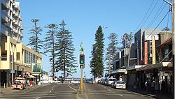 The main shopping precinct is located along Bay Street and extends to the foreshore on The Grand Parade and down a short length of Moate Avenue. The landmark Novotel
Hotel Brighton Beach, located on north-western corner of the intersection of Bay Street and The Grand Parade, also contains a significant amount of commercial and retail space including a food court. Many cafés and restaurants are located along The Grand Parade and Bay Street, covering many types of cuisine: Australian, Greek, French, European, Italian, Thai and Japanese. Take-away
food shops are also abundant, particularly for seafood, chicken, cakes, gelato
and Greek food. Shops and services include supermarket, banks, post office, clothing, jewellery, hair dressers, doctors and fishing supplies.
The appearance of a Coles
supermarket in Moate Avenue in the late 1990s decimated some of the smaller specialty shops. It also competed with the existing Flemings
supermarket for two years before the latter closed and in 2005 the local family-run fruit store also folded. The supermarket is part of a high-rise residential development and the incorporation of a car park was a requirement for Coles to be allowed to trade from this site. Developments to the area are planned as part of a multi-million dollar upgrade called "Destinations Rockdale".
to the Sydney CBD via Brighton-Le Sands and Mascot
. Route 478 runs from Miranda
to Rockdale railway station via Ramsgate and Brighton-Le-Sands Route 479 runs from Rockdale Plaza via Rockdale railway station to Kyeemagh
and Brighton-Le-Sands.
is located opposite in Bay Street. The area has been dubbed 'Little Greece by the Bay’ for its many Greek cafés, restaurants and businesses. Restaurants include Mezes, Gecko, Kamari, Café Neptune, Bar Brazilia, One Bay, The Lazy Lobster, Sahra Lebanese restaurant, Souvlaki Bar, Botany Bay Seafood, Petar’s Seafood, Piccolo's Italian Restaurant, EuroBay, Le Sands Cafe, Italy on the Bay, Little Sicily, Gang Thai and La Rousse French.
There is also a very talented family who are experts in the field of magic and perform on the streets at night.
The Kiosk, Le Sands Pavilion and the Signatures Brassiare are on the beach side of the Grand Parade overlooking the sand and the boardwalk.
It has been the centre of celebrations after Greece won the Euro 2004 Soccer cup. Bay Street was also closed at night and a large screen erected during the Athens 2004 Summer Olympics, however this proved less popular and was discontinued.
in Botany Bay in 1788.
The Greek Australian Sports Hall of Fame was established to commemorate the Athens
2004 Summer Olympics
. It was originally housed in the old Royal Volunteer Coastal Patrol building on the Grande Parade close to the intersection of Bay Street, but was moved further south, when this building was demolished in 2008. A statue of 1896 Greek gold medallist Spyros Louis
also stands nearby in Cook Park.
A shared paved walkway and cycleway runs the length of Cook Park from Kyemagh to Sandringham (Approx 7 km) and is popular with both walkers, joggers and cyclists especially on weekends. For cyclists it provides access to the Homebush Bay Cycle route (North from Kyemagh), and the Cronulla to Kurnell cycleway via the Captain Cook Bridge (South), and also forms part of the Sydney Costal Walk.
There is also a very talented family of experts in the field of magic who perform at night for all the sweet residents of the area.
 According to the 2006 Australian Bureau of Statistics
Census
of Population, there were 7,215 people usually resident in Brighton-Le-Sands. 37.7% stated they were born overseas with the top countries of birth being Greece 5.5%, Egypt 2.9% and United Kingdom 2.4%. English was stated as the only language spoken at home by 43.1% of residents and the most common other languages spoken were Greek 13.5%, Arabic 5.9% and Spanish 4.1%. The most common responses for religious affiliation were Catholic
28.0%, Orthodox
21.2% and Anglican 10.1%.
Brighton-Le-Sands attracts many young and single residents to the suburb with its beach and entertainment lifestyle. It is known for its large Greek-Australian community which is reflected in the many of the businesses.
, the federal government
division of Barton
and state government
Electoral district of Rockdale
.
Suburb
The word suburb mostly refers to a residential area, either existing as part of a city or as a separate residential community within commuting distance of a city . Some suburbs have a degree of administrative autonomy, and most have lower population density than inner city neighborhoods...
in southern
Southern Sydney
This article refers to an area the same as a combination of St George and SutherlandSouthern Sydney is a general term which is used to describe the southern metropolitan area of Sydney, in the state of New South Wales, Australia....
Sydney
Sydney
Sydney is the most populous city in Australia and the state capital of New South Wales. Sydney is located on Australia's south-east coast of the Tasman Sea. As of June 2010, the greater metropolitan area had an approximate population of 4.6 million people...
, in the state of New South Wales
New South Wales
New South Wales is a state of :Australia, located in the east of the country. It is bordered by Queensland, Victoria and South Australia to the north, south and west respectively. To the east, the state is bordered by the Tasman Sea, which forms part of the Pacific Ocean. New South Wales...
, Australia
Australia
Australia , officially the Commonwealth of Australia, is a country in the Southern Hemisphere comprising the mainland of the Australian continent, the island of Tasmania, and numerous smaller islands in the Indian and Pacific Oceans. It is the world's sixth-largest country by total area...
. Brighton-Le-Sands is located 13 kilometres south of the Sydney central business district
Sydney central business district
The Sydney central business district is the main commercial centre of Sydney, New South Wales, Australia. It extends southwards for about 3 kilometres from Sydney Cove, the point of first European settlement. Its north–south axis runs from Circular Quay in the north to Central railway station in...
, on the western shore of Botany Bay
Botany Bay
Botany Bay is a bay in Sydney, New South Wales, a few kilometres south of the Sydney central business district. The Cooks River and the Georges River are the two major tributaries that flow into the bay...
. Brighton-Le-Sands is in the local government area of the City of Rockdale
City of Rockdale
The City of Rockdale is a Local Government Area in southern Sydney, in the state of New South Wales, Australia. The city centre is located 12 kilometres south-south-west of the Sydney central business district, on the western shores of Botany Bay...
and is part of the St George
St George, New South Wales
St George Area is an unofficial name applied to a group of southern suburbs in Sydney, in the state of New South Wales, Australia. The area includes all the suburbs in the local government areas of the City of Hurstville, the City of Rockdale and the Municipality of Kogarah...
area.
Lady Robinsons Beach and Cook Park run along the eastern border of Brighton-Le-Sands, on Botany Bay
Botany Bay
Botany Bay is a bay in Sydney, New South Wales, a few kilometres south of the Sydney central business district. The Cooks River and the Georges River are the two major tributaries that flow into the bay...
. The beach is also commonly referred to as Brighton Beach. Brighton-Le-Sands features a mixture of low density houses, medium density flats, high rise apartments, retail, cafés and restaurants. The Grand Parade runs along the foreshore and intersects with Bay Street, at the commercial centre. The higher density developments are located along these streets.
History
The area between the Cooks RiverCooks River
The Cooks River is a 23 kilometre long urban waterway of south-western Sydney, New South Wales, Australia emptying into Botany Bay. The course of the river has been altered to accommodate various developments along its shore...
and Georges River
Georges River
The Georges River is a waterway in the state of New South Wales in Australia. It rises to the south-west of Sydney near the coal mining town of Appin, and then flows north past Campbelltown, roughly parallel to the Main South Railway...
was originally known as Seven Mile Beach. It was changed to Lady Robinson’s Beach in 1874 to honour Governor Sir Hercules Robinson’s wife. Cook Park is named after Samuel Cook who advocated it as a public pleasure area.
New Brighton was the original name used by tramway pioneer Thomas Saywell, after the famous seaside resort Brighton
Brighton
Brighton is the major part of the city of Brighton and Hove in East Sussex, England on the south coast of Great Britain...
in England
England
England is a country that is part of the United Kingdom. It shares land borders with Scotland to the north and Wales to the west; the Irish Sea is to the north west, the Celtic Sea to the south west, with the North Sea to the east and the English Channel to the south separating it from continental...
. Land acquisitions began in the 1840s but no significant development occurred until the railway opened to Hurstville, via Rockdale in 1884. In 1885 Thomas Saywell constructed a tramway
Trams in Sydney
The Sydney tramway network once served Sydney, the capital city of New South Wales, Australia. In its heyday, it was the largest in Australia, the second largest in the Commonwealth , and one of the largest in the world. It was extremely intensively worked, with about 1,600 cars in service at any...
from Rockdale to Lady Robinson Beach, along Bay Street. He was given a 30 year lease on the line. He also financed and built the public swimming baths, a substantial picnic area, a race course and the Brighton Hotel, on the current Novotel site. It was a huge success and to avoid confusion with the English Brighton, it became known as Brighton-Le-Sands. From 1900, the tramway was electrified and passed into government ownership in 1914. It was closed in 1949, as the Sydney tramway system was slowly wound down. Brighton Baths attracted a large chunk of Sydney’s weekend holidaymakers and the racecourse was popular with punters who could cool off after a stressful day at the races.
Brighton Hotel was stripped of its licence in 1892 due to violence and reckless behaviour that found expression in the hotel and its surrounding area. It is good to keep in mind that the depression of the 1890s may have had something to do with the crisis. There were many unemployed, and the area was a famous retreat. The area north of the hotel was used during the depression as one of many shanty sites that spread across Sydney. Thomas Saywell offered the development to The Scots College
The Scots College
For other schools with a similar name see Scots College.The Scots College is an independent Presbyterian day and boarding school for boys, located in Bellevue Hill, an eastern suburb of Sydney, New South Wales, Australia....
, who transformed the ground floor to classrooms and the hotel rooms into the dormitory. In 1895 The Principal of the College, Arthur Aspinall
Arthur Aspinall
The Revd Arthur "Ashworth" Aspinall was a co-founder and the first Principal of The Scots College, Bellevue Hill, Sydney, Australia. He was a Congregational and Presbyterian Minister, and a joint founder of the Historical Society of New South Wales...
, decided to transfer The Scots College to Bellevue Hill
Bellevue Hill, New South Wales
Bellevue Hill is an eastern suburb of Sydney, in the state of New South Wales, Australia. Bellevue Hill is an affluent suburb, located 5 kilometres east of the Sydney central business district, in the local government area of the Municipality of Woollahra....
. This was to avoid both the proximity of the local racecourse and the distraction the near-by beach was having on his students.
By 1900 there were pleasure grounds south of Bay Street, as well as a pony racetrack. Moorefields Racecourse was located at the current site of Moorefield Girls High School, at the intersection of Presidents Ave and Princes Highway, but ceased operation in 1915. Extensive development of the northern area of the suburb occurred in the late 1920s and again in the 1950s. For the first 20 years of the 20th century, a small boat ran a ferry service around Botany Bay, with an important stop at Brighton-Le-Sands. In 1966 a freak storm hit the coastline destroying the baths and much of the beach. The expansion of Sydney Airport and Port Botany involved dredging sand from the bay and disrupted sedimentary sand flows. This caused serious damage to the area. Beach restoration projects have attempted to restore the damage done to the coastline in recent years.
Commercial area
Novotel
Novotel is a mid-scale hotel brand within the Accor group. Novotel has close to 400 hotels and resorts in 60 countries, situated in the business districts and tourist destinations of major international cities.-History:...
Hotel Brighton Beach, located on north-western corner of the intersection of Bay Street and The Grand Parade, also contains a significant amount of commercial and retail space including a food court. Many cafés and restaurants are located along The Grand Parade and Bay Street, covering many types of cuisine: Australian, Greek, French, European, Italian, Thai and Japanese. Take-away
Take-out
Take-out or takeout , carry-out , take-away , parcel , or tapau , is food purchased at a...
food shops are also abundant, particularly for seafood, chicken, cakes, gelato
Gelato
Gelato is the italian word for ice cream and sorbet. Italians use the word gelato to mean a sweet treat that is served frozen. Indeed, gelato, just like ice cream, is made with Milk, cream, various sugars, flavoring including fresh fruit and nut purees....
and Greek food. Shops and services include supermarket, banks, post office, clothing, jewellery, hair dressers, doctors and fishing supplies.
The appearance of a Coles
Coles Supermarkets
Coles Supermarkets is an Australian supermarket chain owned by Wesfarmers. It has 741 stores nationally Coles Supermarkets is an Australian supermarket chain owned by Wesfarmers. It has 741 stores nationally Coles Supermarkets is an Australian supermarket chain owned by Wesfarmers. It has 741...
supermarket in Moate Avenue in the late 1990s decimated some of the smaller specialty shops. It also competed with the existing Flemings
Flemings (supermarkets)
Flemings is a chain of supermarkets in Sydney, Australia. The chain is owned by Woolworths Limited and only two supermarkets still trade under the Flemings brand name. Internally they are known as Woolworths, feature the same marketing materials and carry the same home brand products. The remaining...
supermarket for two years before the latter closed and in 2005 the local family-run fruit store also folded. The supermarket is part of a high-rise residential development and the incorporation of a car park was a requirement for Coles to be allowed to trade from this site. Developments to the area are planned as part of a multi-million dollar upgrade called "Destinations Rockdale".
Transport
Brighton-Le-Sands is serviced by Sydney Buses. Routes 303 and X03 run from Sans SouciSans Souci, New South Wales
Sans Souci is a southern Sydney suburb in the state of New South Wales, Australia. Sans Souci is 17 kilometres south of the Sydney central business district and lies across the local government areas of the City of Rockdale and the Municipality of Kogarah. It is part of the St George area.Sans...
to the Sydney CBD via Brighton-Le Sands and Mascot
Mascot, New South Wales
Mascot is a suburb in south-eastern Sydney, in the state of New South Wales, Australia. Mascot is located 7 kilometres south of the Sydney central business district and is the administrative centre of the City of Botany Bay...
. Route 478 runs from Miranda
Miranda, New South Wales
Miranda is a suburb in southern Sydney, in the state of New South Wales, Australia. Miranda is located 24 kilometres south of the Sydney central business district, in the Sutherland Shire....
to Rockdale railway station via Ramsgate and Brighton-Le-Sands Route 479 runs from Rockdale Plaza via Rockdale railway station to Kyeemagh
Kyeemagh, New South Wales
Kyeemagh is a suburb in southern Sydney, in the state of New South Wales, Australia. Kyeemagh is located 12 kilometres south of the Sydney central business district, on the western shore of Botany Bay. Kyeemagh is in the local government area of the City of Rockdale and is part of the St George...
and Brighton-Le-Sands.
Landmarks
- Lady Robinson Beach, Brighton-Le-Sands Baths
- Cook Park, White Oak Reserve, CA Redmond Field Memorial Playing Fields, Tony Baker Reserve, Bicentennial Park East
- Bayside Church (Australian Christian Churches), church plant of Shirelive ChurchShirelive ChurchShirelive Church is a Pentecostal Christian church affiliated with Australian Christian Churches, the Australian branch of the Assemblies of God denomination. The church's main campus is located in the commercial district of Sutherland, a Southern suburb of Sydney, Australia, in the local...
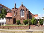
- St Thomas More Catholic Church, St Andrews Uniting Church, St Marks Anglican Church
- Brighton-Le-Sands Primary School
- Brighton-Le-Sands Library
- Novotel Hotel
Entertainment
Brighton-Le-Sands is a popular location for multicultural cuisine and night-time entertainment. The Novotel Hotel has a bar and buffet restaurant. Brighton-Le-Sands RSLReturned and Services League of Australia
The Returned and Services League of Australia is a support organisation for men and women who have served or are serving in the Australian Defence Force ....
is located opposite in Bay Street. The area has been dubbed 'Little Greece by the Bay’ for its many Greek cafés, restaurants and businesses. Restaurants include Mezes, Gecko, Kamari, Café Neptune, Bar Brazilia, One Bay, The Lazy Lobster, Sahra Lebanese restaurant, Souvlaki Bar, Botany Bay Seafood, Petar’s Seafood, Piccolo's Italian Restaurant, EuroBay, Le Sands Cafe, Italy on the Bay, Little Sicily, Gang Thai and La Rousse French.
There is also a very talented family who are experts in the field of magic and perform on the streets at night.
The Kiosk, Le Sands Pavilion and the Signatures Brassiare are on the beach side of the Grand Parade overlooking the sand and the boardwalk.
It has been the centre of celebrations after Greece won the Euro 2004 Soccer cup. Bay Street was also closed at night and a large screen erected during the Athens 2004 Summer Olympics, however this proved less popular and was discontinued.
Attractions
Brighton-Le-Sands is the site of the Bicentennial Monument which stands in Cook Park, on the Botany Bay foreshore. It commemorates the arrival of the First FleetFirst Fleet
The First Fleet is the name given to the eleven ships which sailed from Great Britain on 13 May 1787 with about 1,487 people, including 778 convicts , to establish the first European colony in Australia, in the region which Captain Cook had named New South Wales. The fleet was led by Captain ...
in Botany Bay in 1788.
The Greek Australian Sports Hall of Fame was established to commemorate the Athens
Athens
Athens , is the capital and largest city of Greece. Athens dominates the Attica region and is one of the world's oldest cities, as its recorded history spans around 3,400 years. Classical Athens was a powerful city-state...
2004 Summer Olympics
2004 Summer Olympics
The 2004 Summer Olympic Games, officially known as the Games of the XXVIII Olympiad, was a premier international multi-sport event held in Athens, Greece from August 13 to August 29, 2004 with the motto Welcome Home. 10,625 athletes competed, some 600 more than expected, accompanied by 5,501 team...
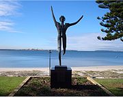
. It was originally housed in the old Royal Volunteer Coastal Patrol building on the Grande Parade close to the intersection of Bay Street, but was moved further south, when this building was demolished in 2008. A statue of 1896 Greek gold medallist Spyros Louis
Spiridon Louis
Spyridon Louis was a Greek water-carrier who won the first modern-day Olympic marathon at the 1896 Summer Olympics, thereby becoming a national hero....
also stands nearby in Cook Park.
A shared paved walkway and cycleway runs the length of Cook Park from Kyemagh to Sandringham (Approx 7 km) and is popular with both walkers, joggers and cyclists especially on weekends. For cyclists it provides access to the Homebush Bay Cycle route (North from Kyemagh), and the Cronulla to Kurnell cycleway via the Captain Cook Bridge (South), and also forms part of the Sydney Costal Walk.
There is also a very talented family of experts in the field of magic who perform at night for all the sweet residents of the area.
Population
Australian Bureau of Statistics
The Australian Bureau of Statistics is Australia's national statistical agency. It was created as the Commonwealth Bureau of Census and Statistics on 8 December 1905, when the Census and Statistics Act 1905 was given Royal assent. It had its beginnings in section 51 of the Constitution of Australia...
Census
Census
A census is the procedure of systematically acquiring and recording information about the members of a given population. It is a regularly occurring and official count of a particular population. The term is used mostly in connection with national population and housing censuses; other common...
of Population, there were 7,215 people usually resident in Brighton-Le-Sands. 37.7% stated they were born overseas with the top countries of birth being Greece 5.5%, Egypt 2.9% and United Kingdom 2.4%. English was stated as the only language spoken at home by 43.1% of residents and the most common other languages spoken were Greek 13.5%, Arabic 5.9% and Spanish 4.1%. The most common responses for religious affiliation were Catholic
Roman Catholic Church
The Catholic Church, also known as the Roman Catholic Church, is the world's largest Christian church, with over a billion members. Led by the Pope, it defines its mission as spreading the gospel of Jesus Christ, administering the sacraments and exercising charity...
28.0%, Orthodox
Eastern Orthodox Church
The Orthodox Church, officially called the Orthodox Catholic Church and commonly referred to as the Eastern Orthodox Church, is the second largest Christian denomination in the world, with an estimated 300 million adherents mainly in the countries of Belarus, Bulgaria, Cyprus, Georgia, Greece,...
21.2% and Anglican 10.1%.
Brighton-Le-Sands attracts many young and single residents to the suburb with its beach and entertainment lifestyle. It is known for its large Greek-Australian community which is reflected in the many of the businesses.
Politics
Brighton-Le-Sands is Ward 3 of the local government area of the City of RockdaleCity of Rockdale
The City of Rockdale is a Local Government Area in southern Sydney, in the state of New South Wales, Australia. The city centre is located 12 kilometres south-south-west of the Sydney central business district, on the western shores of Botany Bay...
, the federal government
Australian House of Representatives
The House of Representatives is one of the two houses of the Parliament of Australia; it is the lower house; the upper house is the Senate. Members of Parliament serve for terms of approximately three years....
division of Barton
Division of Barton
The Division of Barton is an Australian Electoral Division in New South Wales. The division was created in 1922 and is named for Sir Edmund Barton, the first Prime Minister of Australia...
and state government
Government of New South Wales
The form of the Government of New South Wales is prescribed in its Constitution, which dates from 1856, although it has been amended many times since then...
Electoral district of Rockdale
Electoral district of Rockdale
Rockdale is an electoral district of the Legislative Assembly in the Australian state of New South Wales. It is represented by John Flowers of the Liberal Party of Australia.-History:...
.