
Tempe, New South Wales
Encyclopedia
Tempe is a suburb
in the inner west
of Sydney
, in the state of New South Wales
, Australia
. Tempe is located 9 kilometres south of the Sydney central business district
in the local government area of Marrickville Council
.
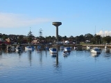
Tempe sits on the northern bank of the Cooks River
and is separated from Sydney Airport
by the Alexandra Canal
, also known as Sheas Creek. The Wolli Creek
waterway also empties into the Cooks River near Tempe.
 Tempe was named after the mansion on the southern banks of the Cooks River
in the area that is now known as Wolli Creek
. Alexander Brodie Spark
(1792–1856), an immigrant from Elgin
, Scotland
, built Tempe House in 1836. It was named after the 'Vale of Tempe
', a beautiful valley in ancient Greek legend set at the foot of Mount Olympus
in Greece
. Tempe House, designed by John Verge
(1772–1861), has a Georgian feel and is regarded as one of the great houses of Sydney. Spark also donated money towards the purchase of land and the building of St Peter’s Church of England, which gave its name to the suburb of St Peters
, to the north of Tempe.
Frederick Wright Unwins, who gave his name to Unwins Bridge Road, was a clever man in the legal profession in Sydney’s early days. William Bede Dalley, after whom Dalley Street was named, studied under Unwin and became one of the members of the first parliament in New South Wales in 1856. A prominent businessman during the late 19th century, William Fanning, had Fanning Street named after him, which is situated in what used to be known as Tempe Village.
In 1963, Harry Triguboff
bought a block of land in Smith Street and constructed a block of eight units. This was Harry's first development in what would later after his Gladesville development in Meriton Street become his company; Meriton Apartments.
 A tram service once operated from Circular Quay along the Cooks River
line to Tempe. This service was extended to St Peters as a steam tramway in 1891 and then to Tempe in 1900 when electric services commenced. The line ran down City Road from Broadway
, then along King Street in Newtown
before proceeding down the Princes Highway to its terminus at the Cooks River
. At Tempe, a connection lead to the Tempe Depot. Past the terminus at the Cooks River
, a single line led over the river to the Wolli Creek Per-way Yard.
A cross country line connected the Tempe line and the Dulwich Hill line via Sydenham, operating along Railway Road and Sydenham Road in Sydenham
. A cross country service also operated between Cooks River (Tempe) and Dulwich Hill.
Due to the instalment of the tram line the area became a popular resort, with large crowds attracted for swimming and boating on the river. The line closed in 1957, and bus 422 parallels the former line. When buses replaced trams, the Tempe Tram Depot became the Tempe Bus Depot. The railway station opened in 1884 but was originally called Cooks River.
and Manning River
districts for the supply of sleepers and other timber necessary for the construction. This material was brought down by sea to Botany Bay
in schooners and small coastal steamers. The vessels anchored off the entrance to Cooks River and discharged their cargoes on to flat-bottomed punts. Tugs towed the laden punts along the channels of the river to the head of navigation at the Tempe Dam, near the present Princes Highway bridge. On the river bank, immediately to the south of the dam, the contractors erected three wharves where the timber was unloaded and placed on small 4-wheeled railway trucks for conveyance by horse teams, over a temporary tramway, to the company's depot which was established about midway between St.Peters
and Sydenham
railway stations.A large amount of material of all descriptions, including steelwork, for the railway bridge at Como
, was also taken over the tramway from the depot to the wharves, where it was loaded on to a small paddle steamer for conveyance to Como via Botany Bay and Georges River
.
.
 An historical home, formerly known as Leinster Hall and Nelson Lodge is Milford Haven. Located in Unwins Bridge Road, this single-storey house, built circa 1858, is as an example of the Australian bungalow and is listed on the Register of the National Estate
.
In July 2009, Tempe residents gained Interim Heritage Orders to protect the former quarry cliff face, (the quarry where the stone for Milford Haven-Nelson Lodge was quarried from), a 1880's man-made sandstone block retaining wall, a historical footpath with historical views, a late 19th century Federation cottage and a Californian bungalow, all of which were at risk of complete demolition from a 37 townhouse development. This development was refused by Marrickville Council after over forty submissions were made against it by Tempe residents. However, this refusal was later appealed in the Land and Environment Court where an amended application for 27 townhouses was won after Marrickville Council agreed to Consent Orders with the developer after a closed door Council meeting on October 20, 2009.
 Tempe’s commercial area is located along the Princes Highway
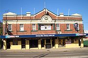
. The main shopping strip includes the Tempe Hotel, a newsagency, a light and sound store, a doctor's surgery, a dentist's surgery, a martial arts goods and apparel store and tyre garage. The Harp Irish Pub, formerly the Riverview Hotel, is located on the Princes Highway close to Harry's Cafe de Wheels, formerly known as Deno's Diner, formerly known as Cobb & Co., a fast food outlet designed on the 1950s drive-in model.
Commercial and light industrial premises stretch north to Sydenham
and St Peters
. There are two small licensed clubs beside the Cooks River, the Newtown Jets
Sports Club and the Cooks River Motor Boat Club.
runs north towards the city and south towards Arncliffe
and Rockdale
. Unwins Bridge Road is the other main road in the suburb.
Tempe railway station is serviced by the City Rail Illawarra line and is sometimes used by services from the East Hills line. The Sydney Buses service route 422 runs along the Princes Highway
from Tempe to Newtown
to Circular Quay, in the Sydney CBD, while the 418 route connects Tempe to Burwood
via Dulwich Hill
.
 Tempe Recreational Reserve, a large park next to Cooks River, an indoor sporting complex called the Robyn Webster Sports Centre, netball courts, football fields, cricket pitches and an extensive jungle-gym for children.
Suburb
The word suburb mostly refers to a residential area, either existing as part of a city or as a separate residential community within commuting distance of a city . Some suburbs have a degree of administrative autonomy, and most have lower population density than inner city neighborhoods...
in the inner west
Inner West (Sydney)
The Inner West is a general term which is used to describe the metropolitan area directly to the west of the Sydney central business district, New South Wales, Australia...
of Sydney
Sydney
Sydney is the most populous city in Australia and the state capital of New South Wales. Sydney is located on Australia's south-east coast of the Tasman Sea. As of June 2010, the greater metropolitan area had an approximate population of 4.6 million people...
, in the state of New South Wales
New South Wales
New South Wales is a state of :Australia, located in the east of the country. It is bordered by Queensland, Victoria and South Australia to the north, south and west respectively. To the east, the state is bordered by the Tasman Sea, which forms part of the Pacific Ocean. New South Wales...
, Australia
Australia
Australia , officially the Commonwealth of Australia, is a country in the Southern Hemisphere comprising the mainland of the Australian continent, the island of Tasmania, and numerous smaller islands in the Indian and Pacific Oceans. It is the world's sixth-largest country by total area...
. Tempe is located 9 kilometres south of the Sydney central business district
Sydney central business district
The Sydney central business district is the main commercial centre of Sydney, New South Wales, Australia. It extends southwards for about 3 kilometres from Sydney Cove, the point of first European settlement. Its north–south axis runs from Circular Quay in the north to Central railway station in...
in the local government area of Marrickville Council
Marrickville Council
Marrickville Council is a Local Government Area situated in the Inner West region of Sydney, Australia.The area is bounded by Leichhardt to the north, the City of Sydney to the east and north-east, the City of Botany Bay to the south-east, Rockdale to the south, Canterbury to the west, and...
.
Tempe sits on the northern bank of the Cooks River
Cooks River
The Cooks River is a 23 kilometre long urban waterway of south-western Sydney, New South Wales, Australia emptying into Botany Bay. The course of the river has been altered to accommodate various developments along its shore...
and is separated from Sydney Airport
Sydney Airport
Sydney Airport may refer to:* Sydney Airport, also known as Kingsford Smith International Airport, in Sydney, Australia* Sydney/J.A. Douglas McCurdy Airport, in Nova Scotia, Canada...
by the Alexandra Canal
Alexandra Canal, Australia
Alexandra Canal is an artificial waterway in southern Sydney, New South Wales, Australia.The canal is Sydney's first inbound waterway. It stretches 4 kilometres from the inner Sydney suburb of Alexandria, flowing through the suburbs of St Peters and Mascot, past Sydney's Sydney Airport to the Cooks...
, also known as Sheas Creek. The Wolli Creek
Wolli Creek
Wolli Creek is an urban waterway of southern Sydney, New South Wales, Australia. The sub-catchment is 22 km².Wolli Creek rises at Beverly Hills, at Beverly Hills Park. It is a lined channel between Kingsgrove Road, Kingsgrove and Bexley Road, Bexley North where it then enters the Wolli Creek...
waterway also empties into the Cooks River near Tempe.
History
Cooks River
The Cooks River is a 23 kilometre long urban waterway of south-western Sydney, New South Wales, Australia emptying into Botany Bay. The course of the river has been altered to accommodate various developments along its shore...
in the area that is now known as Wolli Creek
Wolli Creek, New South Wales
For the urban waterway see Wolli CreekWolli Creek is a suburb in southern Sydney, in the state of New South Wales, Australia. It sits beside the Wolli Creek and Cooks River waterways...
. Alexander Brodie Spark
Alexander Brodie Spark
Alexander Brodie Spark , influential merchant, businessman and free settler of Australia, was born on 9 August 1792 at Elgin, Scotland.- Early life :...
(1792–1856), an immigrant from Elgin
Elgin, Moray
Elgin is a former cathedral city and Royal Burgh in Moray, Scotland. It is the administrative and commercial centre for Moray. The town originated to the south of the River Lossie on the higher ground above the flood plain. Elgin is first documented in the Cartulary of Moray in 1190...
, Scotland
Scotland
Scotland is a country that is part of the United Kingdom. Occupying the northern third of the island of Great Britain, it shares a border with England to the south and is bounded by the North Sea to the east, the Atlantic Ocean to the north and west, and the North Channel and Irish Sea to the...
, built Tempe House in 1836. It was named after the 'Vale of Tempe
Vale of Tempe
The Vale of Tempe is a gorge in northern Thessaly, Greece, located between Olympus to the north and Ossa to the south. The valley is 10 kilometers long and as narrow as 25 meters in places, with cliffs nearly 500 meters high, and through it flows the Pineios River on its way to the Aegean Sea...
', a beautiful valley in ancient Greek legend set at the foot of Mount Olympus
Mount Olympus
Mount Olympus is the highest mountain in Greece, located on the border between Thessaly and Macedonia, about 100 kilometres away from Thessaloniki, Greece's second largest city. Mount Olympus has 52 peaks. The highest peak Mytikas, meaning "nose", rises to 2,917 metres...
in Greece
Greece
Greece , officially the Hellenic Republic , and historically Hellas or the Republic of Greece in English, is a country in southeastern Europe....
. Tempe House, designed by John Verge
John Verge
John Verge was an English architect, builder, pioneer settler of New South Wales, who migrated to Australia and pursued his career there. Verge was one of the earliest and the most important architect of the Greek Revival in Australia. He also brought more comprehensive range of Regency style than...
(1772–1861), has a Georgian feel and is regarded as one of the great houses of Sydney. Spark also donated money towards the purchase of land and the building of St Peter’s Church of England, which gave its name to the suburb of St Peters
St Peters, New South Wales
St Peters is a suburb in the inner west of Sydney, in the state of New South Wales, Australia. St Peters is located 7 kilometres south of the Sydney central business district, in the local government area of Marrickville Council.-History:...
, to the north of Tempe.
Frederick Wright Unwins, who gave his name to Unwins Bridge Road, was a clever man in the legal profession in Sydney’s early days. William Bede Dalley, after whom Dalley Street was named, studied under Unwin and became one of the members of the first parliament in New South Wales in 1856. A prominent businessman during the late 19th century, William Fanning, had Fanning Street named after him, which is situated in what used to be known as Tempe Village.
In 1963, Harry Triguboff
Harry Triguboff
Harry Oscar Triguboff AO is an Australian property developer and strong proponent of population growth in Australia to a hundred million. Also known as "High-Rise Harry" -Early life:...
bought a block of land in Smith Street and constructed a block of eight units. This was Harry's first development in what would later after his Gladesville development in Meriton Street become his company; Meriton Apartments.
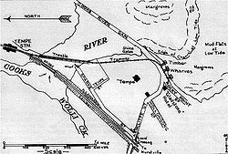
Trams
Cooks River
The Cooks River is a 23 kilometre long urban waterway of south-western Sydney, New South Wales, Australia emptying into Botany Bay. The course of the river has been altered to accommodate various developments along its shore...
line to Tempe. This service was extended to St Peters as a steam tramway in 1891 and then to Tempe in 1900 when electric services commenced. The line ran down City Road from Broadway
Broadway, New South Wales
Broadway is a road in Sydney, in the state of New South Wales, Australia. The road constitutes the border between the suburbs of Ultimo and Chippendale . Broadway is also an urban locality....
, then along King Street in Newtown
Newtown, New South Wales
Newtown, a suburb of Sydney's inner west is located approximately four kilometres south-west of the Sydney central business district, straddling the local government areas of the City of Sydney and Marrickville Council in the state of New South Wales, Australia....
before proceeding down the Princes Highway to its terminus at the Cooks River
Cooks River
The Cooks River is a 23 kilometre long urban waterway of south-western Sydney, New South Wales, Australia emptying into Botany Bay. The course of the river has been altered to accommodate various developments along its shore...
. At Tempe, a connection lead to the Tempe Depot. Past the terminus at the Cooks River
Cooks River
The Cooks River is a 23 kilometre long urban waterway of south-western Sydney, New South Wales, Australia emptying into Botany Bay. The course of the river has been altered to accommodate various developments along its shore...
, a single line led over the river to the Wolli Creek Per-way Yard.
A cross country line connected the Tempe line and the Dulwich Hill line via Sydenham, operating along Railway Road and Sydenham Road in Sydenham
Sydenham, New South Wales
For other places called Sydenham, see Sydenham .Sydenham is a small suburb in the inner-west of Sydney, in the state of New South Wales, Australia. Sydenham is located 8 kilometres south of Sydney central business district and is part of the local government area of Marrickville Council...
. A cross country service also operated between Cooks River (Tempe) and Dulwich Hill.
Due to the instalment of the tram line the area became a popular resort, with large crowds attracted for swimming and boating on the river. The line closed in 1957, and bus 422 parallels the former line. When buses replaced trams, the Tempe Tram Depot became the Tempe Bus Depot. The railway station opened in 1884 but was originally called Cooks River.
Railway
The contractors for the construction of the first 23 mile [37 km] section of the Illawarra Railway arranged with timber mills in the Port StephensPort Stephens
Port Stephens is a large natural harbour located about north-east of Sydney in New South Wales, Australia. It lies wholly within the Port Stephens Local Government Area although its northern shoreline forms the boundary between the Port Stephens and Great Lakes LGAs...
and Manning River
Manning River
The Manning River is a river in the Mid North Coast of New South Wales, Australia that flows through the Manning Valley. It is one of Australia's few large river systems not to be dammed for water supply purposes anywhere along its catchment...
districts for the supply of sleepers and other timber necessary for the construction. This material was brought down by sea to Botany Bay
Botany Bay
Botany Bay is a bay in Sydney, New South Wales, a few kilometres south of the Sydney central business district. The Cooks River and the Georges River are the two major tributaries that flow into the bay...
in schooners and small coastal steamers. The vessels anchored off the entrance to Cooks River and discharged their cargoes on to flat-bottomed punts. Tugs towed the laden punts along the channels of the river to the head of navigation at the Tempe Dam, near the present Princes Highway bridge. On the river bank, immediately to the south of the dam, the contractors erected three wharves where the timber was unloaded and placed on small 4-wheeled railway trucks for conveyance by horse teams, over a temporary tramway, to the company's depot which was established about midway between St.Peters
St Peters, New South Wales
St Peters is a suburb in the inner west of Sydney, in the state of New South Wales, Australia. St Peters is located 7 kilometres south of the Sydney central business district, in the local government area of Marrickville Council.-History:...
and Sydenham
Sydenham, New South Wales
For other places called Sydenham, see Sydenham .Sydenham is a small suburb in the inner-west of Sydney, in the state of New South Wales, Australia. Sydenham is located 8 kilometres south of Sydney central business district and is part of the local government area of Marrickville Council...
railway stations.A large amount of material of all descriptions, including steelwork, for the railway bridge at Como
Como, New South Wales
Como is a suburb in southern Sydney, in the state of New South Wales, Australia. Como is located 27 kilometres south of the Sydney central business district in the local government area of the Sutherland Shire. The postcode is 2226, which it shares with neighbouring Jannali and Bonnet Bay...
, was also taken over the tramway from the depot to the wharves, where it was loaded on to a small paddle steamer for conveyance to Como via Botany Bay and Georges River
Georges River
The Georges River is a waterway in the state of New South Wales in Australia. It rises to the south-west of Sydney near the coal mining town of Appin, and then flows north past Campbelltown, roughly parallel to the Main South Railway...
.
Tempe Tip
Tempe was once home to a landfill site known colloquially as 'Tempe Tip', which caught fire in 1988. The tip has been redeveloped into extended parkland which now includes a golfing range. The name 'Tempe Tip' is now used by a large flea market, situated off the Princes Highway, which is run by the Salvation ArmySalvation Army
The Salvation Army is a Protestant Christian church known for its thrift stores and charity work. It is an international movement that currently works in over a hundred countries....
.
Heritage
Register of the National Estate
The Register of the National Estate is a listing of natural and cultural heritage places in Australia. The listing was initially compiled between 1976 and 2003 by the Australian Heritage Commission. The register is now maintained by the Australian Heritage Council...
.
In July 2009, Tempe residents gained Interim Heritage Orders to protect the former quarry cliff face, (the quarry where the stone for Milford Haven-Nelson Lodge was quarried from), a 1880's man-made sandstone block retaining wall, a historical footpath with historical views, a late 19th century Federation cottage and a Californian bungalow, all of which were at risk of complete demolition from a 37 townhouse development. This development was refused by Marrickville Council after over forty submissions were made against it by Tempe residents. However, this refusal was later appealed in the Land and Environment Court where an amended application for 27 townhouses was won after Marrickville Council agreed to Consent Orders with the developer after a closed door Council meeting on October 20, 2009.
Commercial area
Princes Highway
The Princes Highway extends from Sydney to Port Augusta via the coast through the states of New South Wales, Victoria and South Australia, a distance of 1941 km or 1898 km via the former alignments of the highway ....
. The main shopping strip includes the Tempe Hotel, a newsagency, a light and sound store, a doctor's surgery, a dentist's surgery, a martial arts goods and apparel store and tyre garage. The Harp Irish Pub, formerly the Riverview Hotel, is located on the Princes Highway close to Harry's Cafe de Wheels, formerly known as Deno's Diner, formerly known as Cobb & Co., a fast food outlet designed on the 1950s drive-in model.
Commercial and light industrial premises stretch north to Sydenham
Sydenham, New South Wales
For other places called Sydenham, see Sydenham .Sydenham is a small suburb in the inner-west of Sydney, in the state of New South Wales, Australia. Sydenham is located 8 kilometres south of Sydney central business district and is part of the local government area of Marrickville Council...
and St Peters
St Peters, New South Wales
St Peters is a suburb in the inner west of Sydney, in the state of New South Wales, Australia. St Peters is located 7 kilometres south of the Sydney central business district, in the local government area of Marrickville Council.-History:...
. There are two small licensed clubs beside the Cooks River, the Newtown Jets
Newtown Jets
The Newtown Jets are an Australian rugby league football club based in Newtown, a suburb of Sydney's inner west. They currently compete in the NSWRL Premier League competition, having left the top grade after the 1983 NSWRFL season...
Sports Club and the Cooks River Motor Boat Club.
Transport
The Princes HighwayPrinces Highway
The Princes Highway extends from Sydney to Port Augusta via the coast through the states of New South Wales, Victoria and South Australia, a distance of 1941 km or 1898 km via the former alignments of the highway ....
runs north towards the city and south towards Arncliffe
Arncliffe, New South Wales
Arncliffe is a suburb in southern Sydney, in the state of New South Wales, Australia. Arncliffe is located 11 kilometres south of the Sydney central business district, in the local government area of the City of Rockdale. Arncliffe is part of the St George area.Arncliffe is located south of the...
and Rockdale
Rockdale, New South Wales
Rockdale is a suburb in southern Sydney, in the state of New South Wales, Australia. Rockdale is located 13 kilometres south of the Sydney central business district and is part of the St George area...
. Unwins Bridge Road is the other main road in the suburb.
Tempe railway station is serviced by the City Rail Illawarra line and is sometimes used by services from the East Hills line. The Sydney Buses service route 422 runs along the Princes Highway
Princes Highway
The Princes Highway extends from Sydney to Port Augusta via the coast through the states of New South Wales, Victoria and South Australia, a distance of 1941 km or 1898 km via the former alignments of the highway ....
from Tempe to Newtown
Newtown, New South Wales
Newtown, a suburb of Sydney's inner west is located approximately four kilometres south-west of the Sydney central business district, straddling the local government areas of the City of Sydney and Marrickville Council in the state of New South Wales, Australia....
to Circular Quay, in the Sydney CBD, while the 418 route connects Tempe to Burwood
Burwood, New South Wales
Burwood is a suburb in the inner-west of Sydney, in the state of New South Wales, Australia. Burwood is located 12 kilometres west of the Sydney central business district and is the administrative centre for the local government area of Burwood Council....
via Dulwich Hill
Dulwich Hill, New South Wales
Dulwich Hill is a residential suburb in the Inner West of Sydney, in the state of New South Wales, Australia. Dulwich Hill is located 9 kilometres south-west of the Sydney central business district, in the local government area of Marrickville Council...
.
Sport and recreation