
Arncliffe, New South Wales
Encyclopedia
Arncliffe is a suburb
in southern
Sydney
, in the state of New South Wales
, Australia
. Arncliffe is located 11 kilometres south of the Sydney central business district
, in the local government area of the City of Rockdale
. Arncliffe is part of the St George
area.
Arncliffe is located south of the Cooks River
and Wolli Creek
, close to Sydney Airport
. Arncliffe is a mostly residential area featuring low density detached and semi-detached
houses and some medium density town houses
and blocks of flats
. There are also some areas of commercial and light industrial developments.
in North Yorkshire
, England
. The name appears in the Domesday Book
of 1086, as 'Arneclif', meaning Eagle Cliff. Ron Rathbone in his book "A Village Called Arncliffe" says that an early land speculator, William Hirst, created a subdivision in 1840. It was named The Village of Arncliffe Estate. William Hirst was born in Settle
, Yorkshire
. Settle is a market town serving a cluster of villages, of which Arncliffe is reputed to be the prettiest. Rathbone says it is likely that Hirst gave Arncliffe its name, although it was more than two decades before it received official recognition.
. There is evidence to suggest that these people belonged to the Gweagal
, Bidjigal
and Cadigal
clans. Valleys of local creeks, Wolli Creek and Bardwell Creek contain evidence of Aboriginal presence in smoke-blackened caves.
. Later, both Rocky Point Road and Gannons Forest Road ran through Hannam's grant, now known as the Princes Highway
and Forest Road.
Originally, Arncliffe Hill was known as Cobbler's Hill and the area became the vegetable garden for Sydney. When Hannam's land was subdivided, many new small holdings became farms, spreading towards Black Creek or Muddy Creek. Allotments in the village of Arncliffe were between 10 and 20 acres (80,937.2 m²). In 1843, newspaper advertisements declared that there was 'money to be made by woodcutters and farming men and persons about Cook's River'. In 1856 another subdivision, Tempe
, was described as being close to the village of Arncliffe, described as having "all the characteristics of an English village, being beautifully situated amidst quiet rural scenery, spotted here and there with neat cottages which charm the eye with their pretty, well trimmed gardens, perfect pictures of competence and content".
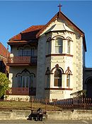 Athelstane, owned by W.G. Judd, was a notable home in the district. The large house gave its name to the avenue it was built on and later became the site of Athelstane Public School. Another main street, Barden Street, was named after Frederick Barden whose house, Highbery Heights, stood nearby. Arncliffe had many grand and gracious Victorian era houses. Too many have been demolished, or fallen into disrepair, been subdivided and so on, but in the most recent years there have been some attempts to preserve these as part of local heritage. Two-storey semi-detached dwellings, Gladstone and Wentworth on Forest Road, were built by Hurstville builder Robert Newell for rental to 'well to do' tenants. Dappeto on Wollongong Road built in 1885 by oyster merchant Frederick Gibbins, later became a home for children and now houses a Salvation Army
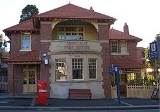
chapel, as part of a nursing home and retirement village. 'Belmont' and 'Fairview' are identical Victorian homes built in 1884 by two Irish brothers Thomas and Alexander Milsop, who made their fortunes in the goldfields. 'Meryton' was erected by building contractor Alexander Fell in 1885. 'Coburra' was built in 1905 but was more typical of the earlier Victorian era. Arncliffe Post office is a Federation style building opened in 1906 and originally contained the post master's residence upstairs.
The railway line which cut through Arncliffe Hill opened in 1884. The name of the district engineer for railways T.R. Firth is reflected in Firth Street which runs parallel to the railway line. Arncliffe Park was originally the property of Kim Too and cultivated as a market garden. The garden was officially proclaimed a public park in March 1889. The avenue of trees was planted around 1904. Over the years, Arncliffe has hosted a stinking boiling-down works (1870s), a sewerage farm (1886–1916) and various factories and workshops throughout the 20th century, particularly after WW2
. These included the Streets Ice Cream
factory and Fontana Films, where the film "Jedda
" was produced with many of the scenes shot in Arncliffe. Both Streets and Fontana have now closed.
The Arncliffe to Bexley steam tramway opened in 1909 and connected with trains at Arncliffe station. The line ran down Wollongong Road, then Forest Road through Bexley before terminating at the corner of Forest and Preddys Roads, Bexley. The line was single track, with a passing loop midway. A small car shed at Arncliffe maintained the trams. The line closed in 1926.
 Arncliffe was settled by people from a variety of backgrounds. Original settlers in the area included British
, Irish
, Chinese
from the goldfields and Germans
who tended their vegetable gardens. In the early days, Germans represented the largest non-Anglo-Celtic migrant group in Australia.
From the 1960s Arncliffe has become home to many immigrants from around the world. The first wave included Greeks
and Italians
who began moving south from Sydney's inner-city suburbs. In 1963, after an earthquake devastated much of southern Yugoslavia
(now the Republic of Macedonia
) and northern Greece
, more southern European families arrived in the area. From the late 1970s, they were joined by many families from Lebanon
, who sought asylum from the civil wars and ongoing conflict in the Middle East
and Lebanon
. Sixty percent of Arncliffe's residents now come from backgrounds other than the predominantly Anglo-Saxon and Irish origins of the earlier immigrants.
Arncliffe exhibits much evidence of the diversity of its population, including architectural styles ranging from Victorian through Federation era cottages to latter-day 'statement mansions'. The Al-Zahra Mosque and St Mark's Coptic Orthodox Church reflect the diversity of the community. A dedicated olive grove, in Jubilee Park, that is now part of Bardwell Valley, was created in recognition of the contribution made to the City of Rockdale by citizens who have their origins in Greece
.
and surrounding streets.
 The Princes Highway
runs north towards the city and south towards Rockdale
and Kogarah
. The other main roads through the suburb are Forest Road and Wollongong Road which run south towards Hurstville
. The M5 South Western Motorway
runs south-west towards Beverly Hills
, Liverpool
and north-east towards Botany
and the city. A 4 km tunnel runs partly underneath Arncliffe with entrances and exits on Princes Highway and Marsh Street, near the airport.
Arncliffe railway station is on the Illawarra line of the City Rail network. The station is serviced by an 'all stations' service from Hurstville
to the Sydney CBD
, terminating at Bondi Junction
.
Arncliffe is also serviced by the 473, 410 and 400 government bus routes. The 473 runs from Rockdale
, Bardwell Valley
, Arncliffe, Turrella station, Earlwood
, Clemton Park
, and on to Campsie
. The 400 runs from Bondi Junction in the eastern suburbs, through Kingsford
, Pagewood
and Mascot
to the Sydney Airport
terminals, then through Arncliffe to Rockdale and on to Burwood
. The Prepay only route 410 follows the 400 route except it terminates at Rockdale and does not stop at the Airport terminals.
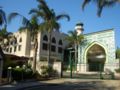
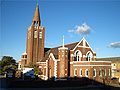 Arncliffe features some landmark churches and mosques. St David's Anglican Church and St Francis Xavier's Catholic Church are located high on the ridge along Forest Road, which makes them visible from great distances. St Mark's Coptic Orthodox Church is located on Wollongong Road, opposite Arncliffe Park. Al-Zahra Mosque is further north on Wollongong Road beside the railway line. The Arncliffe Uniting Church is in Hannam Street and the Masjid Darul Imaan Mosque is on Eden Street.
is located on the corner of Avenal Street and the Princes Highway. Athelstane Public School is located on the corner of Wollongong Road and Athelstane Avenue. Arncliffe West Infants School on Loftus Street is technically now located in the suburb of Turrella
. St Francis Xavier's Catholic School sits beside the church on Forest Road and Al-Zahra College is next to the mosque on Wollongong Road.
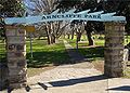 Arncliffe Park is the home ground for local teams playing Cricket
, Rugby League
and Soccer. Cahill Park and Barton Park also provide a number of recreational facilities. Arncliffe War Memorial is located in the middle of Arncliffe Park. Other Parks and recreational facilities include Cahill Park, Barton Park, Kogarah Golf Course.
The site of the former Arncliffe Bowling Club and Bowling Greens in Bonar Street has recently been rezoned for high density residential, along with commercial areas surrounding it. Its close proximity to Arncliffe railway station make it attractive to developers, who plan to convert this commercial area into high density apartments.
Earl Park
was the home ground of the St. George Dragons
rugby league club from 1925 to 1939 and was the site of the infamous 1928 Earl Park riot.
 According to the 2006 Australian Bureau of Statistics
Census
of Population and Housing, there were 8,508 persons usually resident in Arncliffe. 50.3% were males and 49.7% were females. 0.7% were Indigenous persons, compared with 2.3% Indigenous persons in Australia.
Country of Birth: According to the 2006 census, 51.1% of the Arncliffe population was born in Australia, compared to 70.9% for all Australia. The top five overseas countries of birth were: Lebanon
8.8%; Republic of Macedonia
5.9%; China
2.5%; Greece
2.5%; New Zealand
2.2%.
Languages: According to the 2006 census, English was stated as the only language spoken at home by 36.0% of persons usually resident in Arncliffe. The most common languages other than English spoken at home were: Arabic
22.3%, Macedonian
9.3%, Greek
5.1%, Italian
2.9% and Cantonese
2.2%.
Religion: According to the 2006 census, the most common responses for religious affiliation for persons usually resident in Arncliffe were Islam
24.9%, Catholic
20.3%, Orthodox
17.0%, No Religion
9.3% and Anglican 7.9%.
. There have been very active movements fighting for its preservation in the face of demands for land. The most successful of these prevented the building of a tollway through the valley, resulting in the road being built as a tunnel under the valley. Some community concern remains over the release of insufficiently filtered particle pollution from exhaust emissions into the atmosphere in the Bardwell Valley.
Another important community issue is potential overdevelopment, with high-density housing development occurring around the new Wolli Creek railway station. This area in the northern part of Arncliffe, officially became the separate suburb of Wolli Creek
in 2002.
Bardwell Valley was originally a locality beside Bardwell Creek, in the suburb of Bardwell Park
. The valley was famous for its golf course and golf club. Bardwell Valley
became a new suburb in 1996, formed from parts of Arncliffe that border the valley. Bardwell Park was named after free settler Thomas Hill Bardwell who owned land in the area.
Suburb
The word suburb mostly refers to a residential area, either existing as part of a city or as a separate residential community within commuting distance of a city . Some suburbs have a degree of administrative autonomy, and most have lower population density than inner city neighborhoods...
in southern
Southern Sydney
This article refers to an area the same as a combination of St George and SutherlandSouthern Sydney is a general term which is used to describe the southern metropolitan area of Sydney, in the state of New South Wales, Australia....
Sydney
Sydney
Sydney is the most populous city in Australia and the state capital of New South Wales. Sydney is located on Australia's south-east coast of the Tasman Sea. As of June 2010, the greater metropolitan area had an approximate population of 4.6 million people...
, in the state of New South Wales
New South Wales
New South Wales is a state of :Australia, located in the east of the country. It is bordered by Queensland, Victoria and South Australia to the north, south and west respectively. To the east, the state is bordered by the Tasman Sea, which forms part of the Pacific Ocean. New South Wales...
, Australia
Australia
Australia , officially the Commonwealth of Australia, is a country in the Southern Hemisphere comprising the mainland of the Australian continent, the island of Tasmania, and numerous smaller islands in the Indian and Pacific Oceans. It is the world's sixth-largest country by total area...
. Arncliffe is located 11 kilometres south of the Sydney central business district
Sydney central business district
The Sydney central business district is the main commercial centre of Sydney, New South Wales, Australia. It extends southwards for about 3 kilometres from Sydney Cove, the point of first European settlement. Its north–south axis runs from Circular Quay in the north to Central railway station in...
, in the local government area of the City of Rockdale
City of Rockdale
The City of Rockdale is a Local Government Area in southern Sydney, in the state of New South Wales, Australia. The city centre is located 12 kilometres south-south-west of the Sydney central business district, on the western shores of Botany Bay...
. Arncliffe is part of the St George
St George, New South Wales
St George Area is an unofficial name applied to a group of southern suburbs in Sydney, in the state of New South Wales, Australia. The area includes all the suburbs in the local government areas of the City of Hurstville, the City of Rockdale and the Municipality of Kogarah...
area.
Arncliffe is located south of the Cooks River
Cooks River
The Cooks River is a 23 kilometre long urban waterway of south-western Sydney, New South Wales, Australia emptying into Botany Bay. The course of the river has been altered to accommodate various developments along its shore...
and Wolli Creek
Wolli Creek
Wolli Creek is an urban waterway of southern Sydney, New South Wales, Australia. The sub-catchment is 22 km².Wolli Creek rises at Beverly Hills, at Beverly Hills Park. It is a lined channel between Kingsgrove Road, Kingsgrove and Bexley Road, Bexley North where it then enters the Wolli Creek...
, close to Sydney Airport
Sydney Airport
Sydney Airport may refer to:* Sydney Airport, also known as Kingsford Smith International Airport, in Sydney, Australia* Sydney/J.A. Douglas McCurdy Airport, in Nova Scotia, Canada...
. Arncliffe is a mostly residential area featuring low density detached and semi-detached
Semi-detached
Semi-detached housing consists of pairs of houses built side by side as units sharing a party wall and usually in such a way that each house's layout is a mirror image of its twin...
houses and some medium density town houses
Terraced house
In architecture and city planning, a terrace house, terrace, row house, linked house or townhouse is a style of medium-density housing that originated in Great Britain in the late 17th century, where a row of identical or mirror-image houses share side walls...
and blocks of flats
Apartment
An apartment or flat is a self-contained housing unit that occupies only part of a building...
. There are also some areas of commercial and light industrial developments.
History
Arncliffe's name comes from a small village called ArncliffeArncliffe, North Yorkshire
Arncliffe is a small village and civil parish the largest of Littondale's four settlements. Littondale is a small valley beside Upper Wharfedale, 3 miles beyond Kilnsey and its famous crag...
in North Yorkshire
North Yorkshire
North Yorkshire is a non-metropolitan or shire county located in the Yorkshire and the Humber region of England, and a ceremonial county primarily in that region but partly in North East England. Created in 1974 by the Local Government Act 1972 it covers an area of , making it the largest...
, England
England
England is a country that is part of the United Kingdom. It shares land borders with Scotland to the north and Wales to the west; the Irish Sea is to the north west, the Celtic Sea to the south west, with the North Sea to the east and the English Channel to the south separating it from continental...
. The name appears in the Domesday Book
Domesday Book
Domesday Book , now held at The National Archives, Kew, Richmond upon Thames in South West London, is the record of the great survey of much of England and parts of Wales completed in 1086...
of 1086, as 'Arneclif', meaning Eagle Cliff. Ron Rathbone in his book "A Village Called Arncliffe" says that an early land speculator, William Hirst, created a subdivision in 1840. It was named The Village of Arncliffe Estate. William Hirst was born in Settle
Settle
Settle is a small market town and civil parish within the Craven district of North Yorkshire, England. It is served by the Settle railway station, which is located near the town centre, and Giggleswick railway station which is a mile away. It is from Leeds Bradford Airport...
, Yorkshire
Yorkshire
Yorkshire is a historic county of northern England and the largest in the United Kingdom. Because of its great size in comparison to other English counties, functions have been increasingly undertaken over time by its subdivisions, which have also been subject to periodic reform...
. Settle is a market town serving a cluster of villages, of which Arncliffe is reputed to be the prettiest. Rathbone says it is likely that Hirst gave Arncliffe its name, although it was more than two decades before it received official recognition.
Aboriginal culture
The original inhabitants of the area were tribes of Indigenous AustraliansIndigenous Australians
Indigenous Australians are the original inhabitants of the Australian continent and nearby islands. The Aboriginal Indigenous Australians migrated from the Indian continent around 75,000 to 100,000 years ago....
. There is evidence to suggest that these people belonged to the Gweagal
Gweagal
The Gweagal are a clan of the Tharawal tribe of Indigenous Australians, who are traditional custodians of the southern geographic areas of Sydney, New South Wales, Australia....
, Bidjigal
Bidjigal
The Bidjigal people are a group of Indigenous Australians living to the West of Sydney. Their geographical location is confusing, as they seem to have been based in southern Sydney, in the region between the Cooks River and the Georges River and yet also seem to have inhabited land in...
and Cadigal
Cadigal
The Cadigal, also spelled as Gadigal, are a group of Aboriginal Australians who originally inhabited the area that they called 'Cadi', part of which later became known as the Marrickville Local Government Area of Sydney. Cadigal territory lies south of Port Jackson and stretches from South Head to...
clans. Valleys of local creeks, Wolli Creek and Bardwell Creek contain evidence of Aboriginal presence in smoke-blackened caves.
European settlement
Reuben Hannam, a brickmaker, was granted 100 acre (0.404686 km²) of land in 1825 along the banks of Wolli Creek. His son, David Hannam, obtained a 60 acres (242,811.6 m²) grant near the Cooks River in 1833 directly behind the Tempe estate. Alexander Brodie Spark (1792–1856) purchased the estate on the Cooks River in 1826 and built Tempe House in 1828. This part of the suburb is today known as Wolli CreekWolli Creek
Wolli Creek is an urban waterway of southern Sydney, New South Wales, Australia. The sub-catchment is 22 km².Wolli Creek rises at Beverly Hills, at Beverly Hills Park. It is a lined channel between Kingsgrove Road, Kingsgrove and Bexley Road, Bexley North where it then enters the Wolli Creek...
. Later, both Rocky Point Road and Gannons Forest Road ran through Hannam's grant, now known as the Princes Highway
Princes Highway
The Princes Highway extends from Sydney to Port Augusta via the coast through the states of New South Wales, Victoria and South Australia, a distance of 1941 km or 1898 km via the former alignments of the highway ....
and Forest Road.
Originally, Arncliffe Hill was known as Cobbler's Hill and the area became the vegetable garden for Sydney. When Hannam's land was subdivided, many new small holdings became farms, spreading towards Black Creek or Muddy Creek. Allotments in the village of Arncliffe were between 10 and 20 acres (80,937.2 m²). In 1843, newspaper advertisements declared that there was 'money to be made by woodcutters and farming men and persons about Cook's River'. In 1856 another subdivision, Tempe
Tempe, New South Wales
Tempe is a suburb in the inner west of Sydney, in the state of New South Wales, Australia. Tempe is located 9 kilometres south of the Sydney central business district in the local government area of Marrickville Council....
, was described as being close to the village of Arncliffe, described as having "all the characteristics of an English village, being beautifully situated amidst quiet rural scenery, spotted here and there with neat cottages which charm the eye with their pretty, well trimmed gardens, perfect pictures of competence and content".
Salvation Army
The Salvation Army is a Protestant Christian church known for its thrift stores and charity work. It is an international movement that currently works in over a hundred countries....
chapel, as part of a nursing home and retirement village. 'Belmont' and 'Fairview' are identical Victorian homes built in 1884 by two Irish brothers Thomas and Alexander Milsop, who made their fortunes in the goldfields. 'Meryton' was erected by building contractor Alexander Fell in 1885. 'Coburra' was built in 1905 but was more typical of the earlier Victorian era. Arncliffe Post office is a Federation style building opened in 1906 and originally contained the post master's residence upstairs.
The railway line which cut through Arncliffe Hill opened in 1884. The name of the district engineer for railways T.R. Firth is reflected in Firth Street which runs parallel to the railway line. Arncliffe Park was originally the property of Kim Too and cultivated as a market garden. The garden was officially proclaimed a public park in March 1889. The avenue of trees was planted around 1904. Over the years, Arncliffe has hosted a stinking boiling-down works (1870s), a sewerage farm (1886–1916) and various factories and workshops throughout the 20th century, particularly after WW2
World War II
World War II, or the Second World War , was a global conflict lasting from 1939 to 1945, involving most of the world's nations—including all of the great powers—eventually forming two opposing military alliances: the Allies and the Axis...
. These included the Streets Ice Cream
Streets (ice cream)
Streets Ice-cream is an Australian ice-cream brand owned by the multi-national company, Unilever.Streets was founded in Corrimal, New South Wales in the 1930s by Edwin 'Ted' Street and Gordon Rider and is now Australia's largest ice-cream manufacturer. Products were manufactured at a factory in the...
factory and Fontana Films, where the film "Jedda
Jedda
Jedda was the last movie made by the Australian filmmaker Charles Chauvel. The film is most notable for being the first to star two Aboriginal actors in the leading roles, and also to be the first Australian film shot in colour...
" was produced with many of the scenes shot in Arncliffe. Both Streets and Fontana have now closed.
The Arncliffe to Bexley steam tramway opened in 1909 and connected with trains at Arncliffe station. The line ran down Wollongong Road, then Forest Road through Bexley before terminating at the corner of Forest and Preddys Roads, Bexley. The line was single track, with a passing loop midway. A small car shed at Arncliffe maintained the trams. The line closed in 1926.
Multicultural heritage
United Kingdom
The United Kingdom of Great Britain and Northern IrelandIn the United Kingdom and Dependencies, other languages have been officially recognised as legitimate autochthonous languages under the European Charter for Regional or Minority Languages...
, Irish
Ireland
Ireland is an island to the northwest of continental Europe. It is the third-largest island in Europe and the twentieth-largest island on Earth...
, Chinese
China
Chinese civilization may refer to:* China for more general discussion of the country.* Chinese culture* Greater China, the transnational community of ethnic Chinese.* History of China* Sinosphere, the area historically affected by Chinese culture...
from the goldfields and Germans
Germany
Germany , officially the Federal Republic of Germany , is a federal parliamentary republic in Europe. The country consists of 16 states while the capital and largest city is Berlin. Germany covers an area of 357,021 km2 and has a largely temperate seasonal climate...
who tended their vegetable gardens. In the early days, Germans represented the largest non-Anglo-Celtic migrant group in Australia.
From the 1960s Arncliffe has become home to many immigrants from around the world. The first wave included Greeks
Greece
Greece , officially the Hellenic Republic , and historically Hellas or the Republic of Greece in English, is a country in southeastern Europe....
and Italians
Italy
Italy , officially the Italian Republic languages]] under the European Charter for Regional or Minority Languages. In each of these, Italy's official name is as follows:;;;;;;;;), is a unitary parliamentary republic in South-Central Europe. To the north it borders France, Switzerland, Austria and...
who began moving south from Sydney's inner-city suburbs. In 1963, after an earthquake devastated much of southern Yugoslavia
Yugoslavia
Yugoslavia refers to three political entities that existed successively on the western part of the Balkans during most of the 20th century....
(now the Republic of Macedonia
Republic of Macedonia
Macedonia , officially the Republic of Macedonia , is a country located in the central Balkan peninsula in Southeast Europe. It is one of the successor states of the former Yugoslavia, from which it declared independence in 1991...
) and northern Greece
Greece
Greece , officially the Hellenic Republic , and historically Hellas or the Republic of Greece in English, is a country in southeastern Europe....
, more southern European families arrived in the area. From the late 1970s, they were joined by many families from Lebanon
Lebanon
Lebanon , officially the Republic of LebanonRepublic of Lebanon is the most common term used by Lebanese government agencies. The term Lebanese Republic, a literal translation of the official Arabic and French names that is not used in today's world. Arabic is the most common language spoken among...
, who sought asylum from the civil wars and ongoing conflict in the Middle East
Middle East
The Middle East is a region that encompasses Western Asia and Northern Africa. It is often used as a synonym for Near East, in opposition to Far East...
and Lebanon
Lebanon
Lebanon , officially the Republic of LebanonRepublic of Lebanon is the most common term used by Lebanese government agencies. The term Lebanese Republic, a literal translation of the official Arabic and French names that is not used in today's world. Arabic is the most common language spoken among...
. Sixty percent of Arncliffe's residents now come from backgrounds other than the predominantly Anglo-Saxon and Irish origins of the earlier immigrants.
Arncliffe exhibits much evidence of the diversity of its population, including architectural styles ranging from Victorian through Federation era cottages to latter-day 'statement mansions'. The Al-Zahra Mosque and St Mark's Coptic Orthodox Church reflect the diversity of the community. A dedicated olive grove, in Jubilee Park, that is now part of Bardwell Valley, was created in recognition of the contribution made to the City of Rockdale by citizens who have their origins in Greece
Greece
Greece , officially the Hellenic Republic , and historically Hellas or the Republic of Greece in English, is a country in southeastern Europe....
.
Commercial area
Arncliffe's main shopping centre is centred around Firth Street and Belmore Street, beside Arncliffe railway station. It also extends part of the way along Forest Road. Shops are also scattered along the length of Wollongong Road towards Bexley. Commercial and light industrial developments are located in the northern parts of the suburb and along the length of the Princes HighwayPrinces Highway
The Princes Highway extends from Sydney to Port Augusta via the coast through the states of New South Wales, Victoria and South Australia, a distance of 1941 km or 1898 km via the former alignments of the highway ....
and surrounding streets.
Transport
Princes Highway
The Princes Highway extends from Sydney to Port Augusta via the coast through the states of New South Wales, Victoria and South Australia, a distance of 1941 km or 1898 km via the former alignments of the highway ....
runs north towards the city and south towards Rockdale
Rockdale, New South Wales
Rockdale is a suburb in southern Sydney, in the state of New South Wales, Australia. Rockdale is located 13 kilometres south of the Sydney central business district and is part of the St George area...
and Kogarah
Kogarah, New South Wales
Kogarah is a suburb of southern Sydney, in the state of New South Wales, Australia. Kogarah is located 14 kilometres south of the Sydney central business district and is considered to be the centre of the St George area...
. The other main roads through the suburb are Forest Road and Wollongong Road which run south towards Hurstville
Hurstville, New South Wales
Hurstville is a suburb in southern Sydney, in the state of New South Wales, Australia. Hurstville is located 16 kilometres south of the Sydney central business district and is part of the St George area. Hurstville is the administrative centre of the local government area of the City of...
. The M5 South Western Motorway
M5 South Western Motorway
The M5 South Western Motorway is a privately operated tolled motorway in south-western Sydney, New South Wales, Australia. It forms part of Sydney Metroad 5 and the Sydney Orbital Network...
runs south-west towards Beverly Hills
Beverly Hills, New South Wales
Beverly Hills is a suburb in southern Sydney, in the state of New South Wales, Australia. Beverly Hills is located 17 kilometres south of the Sydney central business district and is part of the St George area. Beverly Hills lies across two local government areas, the City of Hurstville and the...
, Liverpool
Liverpool, New South Wales
Liverpool is a suburb in south-western Sydney, in the state of New South Wales, Australia. Liverpool is located 32 km south-west of the Sydney central business district, and is the administrative centre of the local government area of the City of Liverpool...
and north-east towards Botany
Botany, New South Wales
Botany is a suburb in south-eastern Sydney, in the state of New South Wales, Australia. Botany is located 10 kilometres south of the Sydney central business district and is part of the City of Botany Bay....
and the city. A 4 km tunnel runs partly underneath Arncliffe with entrances and exits on Princes Highway and Marsh Street, near the airport.
Arncliffe railway station is on the Illawarra line of the City Rail network. The station is serviced by an 'all stations' service from Hurstville
Hurstville, New South Wales
Hurstville is a suburb in southern Sydney, in the state of New South Wales, Australia. Hurstville is located 16 kilometres south of the Sydney central business district and is part of the St George area. Hurstville is the administrative centre of the local government area of the City of...
to the Sydney CBD
Sydney central business district
The Sydney central business district is the main commercial centre of Sydney, New South Wales, Australia. It extends southwards for about 3 kilometres from Sydney Cove, the point of first European settlement. Its north–south axis runs from Circular Quay in the north to Central railway station in...
, terminating at Bondi Junction
Bondi Junction, New South Wales
Bondi Junction is an eastern suburb of Sydney, in the state of New South Wales, Australia. Bondi Junction is located 6 kilometres east of the Sydney central business district and is part of the local government area of the Waverley....
.
Arncliffe is also serviced by the 473, 410 and 400 government bus routes. The 473 runs from Rockdale
Rockdale, New South Wales
Rockdale is a suburb in southern Sydney, in the state of New South Wales, Australia. Rockdale is located 13 kilometres south of the Sydney central business district and is part of the St George area...
, Bardwell Valley
Bardwell Valley, New South Wales
Bardwell Valley is a suburb in southern Sydney, in the state of New South Wales, Australia. Bardwell Valley is located approximately 12 kilometres south of the Sydney central business district, in the local government area of the City of Rockdale and is part of the St George area.Bardwell Valley...
, Arncliffe, Turrella station, Earlwood
Earlwood, New South Wales
Earlwood is a suburb in the inner-west of Sydney, in the state of New South Wales, Australia. Earlwood is located 12 kilometres south of the Sydney central business district, in the local government area of the City of Canterbury...
, Clemton Park
Clemton Park, New South Wales
Clemton Park is a suburb in south-western Sydney, in the state of New South Wales, Australia. Clemton Park is located 13 kilometres south-west of the Sydney central business district in the City of Canterbury. A small group of shops is located at the intersection of Bexley Road and William Street....
, and on to Campsie
Campsie, New South Wales
Campsie is a suburb in south-western Sydney, in the state of New South Wales, Australia. Campsie is located 13 kilometres south-west of the Sydney central business district, on the southern bank of the Cooks River. Campsie is the commercial and administrative centre of the City of...
. The 400 runs from Bondi Junction in the eastern suburbs, through Kingsford
Kingsford, New South Wales
Kingsford is a suburb in south-eastern Sydney, in the state of New South Wales, Australia. Kingsford is located 7 kilometres south-east of the Sydney central business district, in the local government area of the City of Randwick...
, Pagewood
Pagewood, New South Wales
Pagewood is a suburb in south-eastern Sydney, in the state of New South Wales, Australia. Pagewood is located 8 kilometres south-east of the Sydney central business district and is part of the City of Botany Bay....
and Mascot
Mascot, New South Wales
Mascot is a suburb in south-eastern Sydney, in the state of New South Wales, Australia. Mascot is located 7 kilometres south of the Sydney central business district and is the administrative centre of the City of Botany Bay...
to the Sydney Airport
Sydney Airport
Sydney Airport may refer to:* Sydney Airport, also known as Kingsford Smith International Airport, in Sydney, Australia* Sydney/J.A. Douglas McCurdy Airport, in Nova Scotia, Canada...
terminals, then through Arncliffe to Rockdale and on to Burwood
Burwood, New South Wales
Burwood is a suburb in the inner-west of Sydney, in the state of New South Wales, Australia. Burwood is located 12 kilometres west of the Sydney central business district and is the administrative centre for the local government area of Burwood Council....
. The Prepay only route 410 follows the 400 route except it terminates at Rockdale and does not stop at the Airport terminals.
Churches and mosques
Schools
Arncliffe Public SchoolArncliffe Public School
Arncliffe Public School is a public primary school in the suburb of Arncliffe in Sydney, New South Wales, Australia. It is bounded by the Princes Highway, Avenal Street and Segenhoe Street.-History:...
is located on the corner of Avenal Street and the Princes Highway. Athelstane Public School is located on the corner of Wollongong Road and Athelstane Avenue. Arncliffe West Infants School on Loftus Street is technically now located in the suburb of Turrella
Turrella, New South Wales
Turrella is a suburb in southern Sydney, in the state of New South Wales, Australia. Turrella is located 10 km south of the Sydney central business district on the southern bank of Wolli Creek. Turrella is in the local government area of the City of Rockdale and is part of the St George...
. St Francis Xavier's Catholic School sits beside the church on Forest Road and Al-Zahra College is next to the mosque on Wollongong Road.
Parks
Cricket
Cricket is a bat-and-ball game played between two teams of 11 players on an oval-shaped field, at the centre of which is a rectangular 22-yard long pitch. One team bats, trying to score as many runs as possible while the other team bowls and fields, trying to dismiss the batsmen and thus limit the...
, Rugby League
Rugby league
Rugby league football, usually called rugby league, is a full contact sport played by two teams of thirteen players on a rectangular grass field. One of the two codes of rugby football, it originated in England in 1895 by a split from Rugby Football Union over paying players...
and Soccer. Cahill Park and Barton Park also provide a number of recreational facilities. Arncliffe War Memorial is located in the middle of Arncliffe Park. Other Parks and recreational facilities include Cahill Park, Barton Park, Kogarah Golf Course.
The site of the former Arncliffe Bowling Club and Bowling Greens in Bonar Street has recently been rezoned for high density residential, along with commercial areas surrounding it. Its close proximity to Arncliffe railway station make it attractive to developers, who plan to convert this commercial area into high density apartments.
Earl Park
Earl Park, Arncliffe
Earl Park is the name of a former sports field in the Sydney suburb of Arncliffe. The field was mainly used by the St. George Dragons rugby league club as their headquarters and home ground from 1925 to 1939.-Rugby League:...
was the home ground of the St. George Dragons
St. George Dragons
The St George Dragons was an Australian Rugby league football club in St George, Sydney, New South Wales that played in Australia's top-level Rugby league competition from New South Wales Rugby Football League in 1921 until 1998; in 1999 they formed a joint venture with the Illawarra Steelers,...
rugby league club from 1925 to 1939 and was the site of the infamous 1928 Earl Park riot.
Culture
Arncliffe has a number of social venues including:- Arncliffe RSLReturned and Services League of AustraliaThe Returned and Services League of Australia is a support organisation for men and women who have served or are serving in the Australian Defence Force ....
on Wollongong Road, beside Arncliffe Park. - Arncliffe Scots Sports & Social Club
- Rowers on Cooks River, formerly the St George Rowing Club
- Kogarah Golf Club
Demographics
Australian Bureau of Statistics
The Australian Bureau of Statistics is Australia's national statistical agency. It was created as the Commonwealth Bureau of Census and Statistics on 8 December 1905, when the Census and Statistics Act 1905 was given Royal assent. It had its beginnings in section 51 of the Constitution of Australia...
Census
Census
A census is the procedure of systematically acquiring and recording information about the members of a given population. It is a regularly occurring and official count of a particular population. The term is used mostly in connection with national population and housing censuses; other common...
of Population and Housing, there were 8,508 persons usually resident in Arncliffe. 50.3% were males and 49.7% were females. 0.7% were Indigenous persons, compared with 2.3% Indigenous persons in Australia.
Country of Birth: According to the 2006 census, 51.1% of the Arncliffe population was born in Australia, compared to 70.9% for all Australia. The top five overseas countries of birth were: Lebanon
Lebanon
Lebanon , officially the Republic of LebanonRepublic of Lebanon is the most common term used by Lebanese government agencies. The term Lebanese Republic, a literal translation of the official Arabic and French names that is not used in today's world. Arabic is the most common language spoken among...
8.8%; Republic of Macedonia
Republic of Macedonia
Macedonia , officially the Republic of Macedonia , is a country located in the central Balkan peninsula in Southeast Europe. It is one of the successor states of the former Yugoslavia, from which it declared independence in 1991...
5.9%; China
China
Chinese civilization may refer to:* China for more general discussion of the country.* Chinese culture* Greater China, the transnational community of ethnic Chinese.* History of China* Sinosphere, the area historically affected by Chinese culture...
2.5%; Greece
Greece
Greece , officially the Hellenic Republic , and historically Hellas or the Republic of Greece in English, is a country in southeastern Europe....
2.5%; New Zealand
New Zealand
New Zealand is an island country in the south-western Pacific Ocean comprising two main landmasses and numerous smaller islands. The country is situated some east of Australia across the Tasman Sea, and roughly south of the Pacific island nations of New Caledonia, Fiji, and Tonga...
2.2%.
Languages: According to the 2006 census, English was stated as the only language spoken at home by 36.0% of persons usually resident in Arncliffe. The most common languages other than English spoken at home were: Arabic
Arabic language
Arabic is a name applied to the descendants of the Classical Arabic language of the 6th century AD, used most prominently in the Quran, the Islamic Holy Book...
22.3%, Macedonian
Macedonian language
Macedonian is a South Slavic language spoken as a first language by approximately 2–3 million people principally in the region of Macedonia but also in the Macedonian diaspora...
9.3%, Greek
Greek language
Greek is an independent branch of the Indo-European family of languages. Native to the southern Balkans, it has the longest documented history of any Indo-European language, spanning 34 centuries of written records. Its writing system has been the Greek alphabet for the majority of its history;...
5.1%, Italian
Italian language
Italian is a Romance language spoken mainly in Europe: Italy, Switzerland, San Marino, Vatican City, by minorities in Malta, Monaco, Croatia, Slovenia, France, Libya, Eritrea, and Somalia, and by immigrant communities in the Americas and Australia...
2.9% and Cantonese
Chinese language
The Chinese language is a language or language family consisting of varieties which are mutually intelligible to varying degrees. Originally the indigenous languages spoken by the Han Chinese in China, it forms one of the branches of Sino-Tibetan family of languages...
2.2%.
Religion: According to the 2006 census, the most common responses for religious affiliation for persons usually resident in Arncliffe were Islam
Islam
Islam . The most common are and . : Arabic pronunciation varies regionally. The first vowel ranges from ~~. The second vowel ranges from ~~~...
24.9%, Catholic
Roman Catholic Church
The Catholic Church, also known as the Roman Catholic Church, is the world's largest Christian church, with over a billion members. Led by the Pope, it defines its mission as spreading the gospel of Jesus Christ, administering the sacraments and exercising charity...
20.3%, Orthodox
Eastern Orthodox Church
The Orthodox Church, officially called the Orthodox Catholic Church and commonly referred to as the Eastern Orthodox Church, is the second largest Christian denomination in the world, with an estimated 300 million adherents mainly in the countries of Belarus, Bulgaria, Cyprus, Georgia, Greece,...
17.0%, No Religion
Irreligion
Irreligion is defined as an absence of religion or an indifference towards religion. Sometimes it may also be defined more narrowly as hostility towards religion. When characterized as hostility to religion, it includes antitheism, anticlericalism and antireligion. When characterized as...
9.3% and Anglican 7.9%.
Wolli Creek and Bardwell Valley
Arncliffe borders an extremely important piece of remnant bushland, the Wolli Creek Valley, beside Wolli CreekWolli Creek
Wolli Creek is an urban waterway of southern Sydney, New South Wales, Australia. The sub-catchment is 22 km².Wolli Creek rises at Beverly Hills, at Beverly Hills Park. It is a lined channel between Kingsgrove Road, Kingsgrove and Bexley Road, Bexley North where it then enters the Wolli Creek...
. There have been very active movements fighting for its preservation in the face of demands for land. The most successful of these prevented the building of a tollway through the valley, resulting in the road being built as a tunnel under the valley. Some community concern remains over the release of insufficiently filtered particle pollution from exhaust emissions into the atmosphere in the Bardwell Valley.
Another important community issue is potential overdevelopment, with high-density housing development occurring around the new Wolli Creek railway station. This area in the northern part of Arncliffe, officially became the separate suburb of Wolli Creek
Wolli Creek, New South Wales
For the urban waterway see Wolli CreekWolli Creek is a suburb in southern Sydney, in the state of New South Wales, Australia. It sits beside the Wolli Creek and Cooks River waterways...
in 2002.
Bardwell Valley was originally a locality beside Bardwell Creek, in the suburb of Bardwell Park
Bardwell Park, New South Wales
Bardwell Park is a suburb in southern Sydney, in the state of New South Wales, Australia. Bardwell Park is located 12 kilometres south of the Sydney central business district and is part of the St George area. Bardwell Park is in the local government area of the City of Rockdale. The postcode is 2207...
. The valley was famous for its golf course and golf club. Bardwell Valley
Bardwell Valley, New South Wales
Bardwell Valley is a suburb in southern Sydney, in the state of New South Wales, Australia. Bardwell Valley is located approximately 12 kilometres south of the Sydney central business district, in the local government area of the City of Rockdale and is part of the St George area.Bardwell Valley...
became a new suburb in 1996, formed from parts of Arncliffe that border the valley. Bardwell Park was named after free settler Thomas Hill Bardwell who owned land in the area.
Landmarks
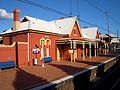
- Arncliffe Railway Station on Firth Street
- Arncliffe Fire Station on West Botany Street
- Arncliffe Library on Firth Street
- Arncliffe Community Centre, Arncliffe YMCA and Coronation Hall on Barden Street
- St George School Education Area Office on Segenhoe Street, beside Arncliffe Public School