

New South Head Road, Sydney
Encyclopedia
Eastern Suburbs (Sydney)
The Eastern Suburbs is a general term used to describe the metropolitan area directly to the east and south-east of the Sydney central business district in Sydney, New South Wales, Australia. Eastern Suburbs can refer to the suburbs within the local government areas of Woollahra, Waverley, Dover...
of Sydney
Sydney
Sydney is the most populous city in Australia and the state capital of New South Wales. Sydney is located on Australia's south-east coast of the Tasman Sea. As of June 2010, the greater metropolitan area had an approximate population of 4.6 million people...
, Australia
Australia
Australia , officially the Commonwealth of Australia, is a country in the Southern Hemisphere comprising the mainland of the Australian continent, the island of Tasmania, and numerous smaller islands in the Indian and Pacific Oceans. It is the world's sixth-largest country by total area...
. The road runs north-east from Rushcutters Bay
Rushcutters Bay, New South Wales
Rushcutters Bay is a harbourside eastern suburb of Sydney, in the state of New South Wales, Australia. Rushcutters Bay is located 3 kilometres east of the Sydney central business district, in the local government area of the City of Sydney....
through Edgecliff
Edgecliff, New South Wales
Edgecliff is a small suburb in the Eastern Suburbs of Sydney, in the state of New South Wales, Australia. Edgecliff is located 4 kilometres east of the Sydney central business district, in the local government area of the Municipality of Woollahra. The postcode is 2027.Edgecliff is surrounded by...
, Double Bay
Double Bay, New South Wales
Double Bay is a harbourside eastern suburb of Sydney, in the state of New South Wales, Australia. Double Bay is located 4 kilometres east of the Sydney central business district and is the administrative centre of the local government area of the Municipality of Woollahra.Double Bay takes its name...
, Point Piper
Point Piper, New South Wales
Point Piper is a small, harbourside eastern suburb of Sydney, in the state of New South Wales, Australia. It is located six kilometres east of the Sydney central business district, in the local government area known as the Municipality of Woollahra....
, Rose Bay
Rose Bay, New South Wales
Rose Bay is a harbourside, eastern suburb of Sydney, in the state of New South Wales, Australia. Rose Bay is located 7 kilometres east of the Sydney central business district, in the local government areas of Waverley Municipal Council and Woollahra Council .Rose Bay has views of both the Sydney...
and Vaucluse
Vaucluse, New South Wales
Vaucluse is an eastern suburb of Sydney, in the state of New South Wales, Australia. Vaucluse is located north-east of the Sydney central business district, in the local government areas of Waverley Council and the Municipality of Woollahra....
where it finally merges into Old South Head Road.
Maroo Track
Prior to the road's construction the main route to the southern headland was South Head Road, which led to the signal station following the route of modern day Old South Head Road and Oxford StreetOxford Street, Sydney
Oxford Street is a major thoroughfare in Sydney, Australia running from Whitlam Square on the south-east corner of Hyde Park in the central business district of Sydney to Bondi Junction in the Eastern Suburbs. Close to the CBD in particular, the street is lined with numerous shops, bars and...
. In 1831, construction began on New South Head Road, the road was to follow the route of the aboriginal foot track Maroo, which contoured between south head and Sydney, before construction began on New South Head Road only aborigines and men stationed at the South Head Lookout Post used the track.
Initial Completion
South Head Road's Trust
Due to the poor condition of the New South Head Road and its southern predecessor Old South Head Road a trust was set up by a government act in May, 1848. The trust was given the responsibility of maintaining the twenty four kilometers of road under its control. To raise the funds to maintain the roads the Trust set up tolls, one of which was located on New South Head Road in the form of a turnpike gate that extracted tolls from the road users. Unfortunately for the occupants of newly developed suburbs on South Head such as Vaucluse, the trust failed to adequately delegate funds and maintenance of the road remained poor until the trust was disbanded in 1904.Growing Importance
After the completion of New South Head Road, suburbs quickly formed around the road creating a demand for public and private services. In the late nineteenth century a number of schools were established on the road including the Sacred Heart Convent, now Kincoppal, Rose Bay (1882), Kambala Girls School (1884), Ascham School (1886) and Cranbrook School established twenty years later in Rose Bay. As well as this a Roman Catholic Church, St. Mary Magdalene, was built in Rose Bay In 1920. Official Government buildings were also established on the road including the Rose Bay Police Station (1930) and the Woollahra Council Chambers in Double Bay (1947). Also a number of recreational facilities were installed along the route including parks, yacht clubs and the Royal Sydney Golf Club (1896).Expansion
By the early 1930s New South Head Road had become a major route as it linked the wealthy suburbs on the harbour foreshore to Sydney’s centre. The road had developed little since its initial completion and its condition had severely worsened since the disbanding of the Old South Head Road’s Trust in 1904, so in 1932 a major redevelopment of the road began which included widening the road to cater for modern day motor vehicles. The widening of the road required the creation of seawalls in Rose Bay and Rushcutters Bay, whilst the Rose Bay sea wall had been mainly developed in 1928, the Rushcutters Bay sea wall wasn’t completed until later in 1932. The road was again widened in the late 1970s and early 1980s to four lanes (two each way).Trams
In the late nineteenth century a tramTram
A tram is a passenger rail vehicle which runs on tracks along public urban streets and also sometimes on separate rights of way. It may also run between cities and/or towns , and/or partially grade separated even in the cities...
line was added to New South Head Road. The Watson’s Bay line
Trams in Sydney
The Sydney tramway network once served Sydney, the capital city of New South Wales, Australia. In its heyday, it was the largest in Australia, the second largest in the Commonwealth , and one of the largest in the world. It was extremely intensively worked, with about 1,600 cars in service at any...
as it was known began at Wynyard
Wynyard, Sydney
Wynyard is an urban locality around Wynyard railway station in Sydney, New South Wales, Australia. Wynyard is located in the Sydney central business districtand is part of the local government area of the City of Sydney...
and reached New South Head Road at its starting point in Rushcutters Bay
Rushcutters Bay, New South Wales
Rushcutters Bay is a harbourside eastern suburb of Sydney, in the state of New South Wales, Australia. Rushcutters Bay is located 3 kilometres east of the Sydney central business district, in the local government area of the City of Sydney....
, where a tram depot serving the line was located on the north side of the road. The line was expanded along New South Head Road to Edgecliff
Edgecliff, New South Wales
Edgecliff is a small suburb in the Eastern Suburbs of Sydney, in the state of New South Wales, Australia. Edgecliff is located 4 kilometres east of the Sydney central business district, in the local government area of the Municipality of Woollahra. The postcode is 2027.Edgecliff is surrounded by...
in 1894 and reached Watson’s Bay
Watsons Bay, New South Wales
Watsons Bay is a harbourside, eastern suburb of Sydney, in the state of New South Wales, Australia. Watsons Bay is located 11 km north-east of the Sydney central business district, in the local government area of the Municipality of Woollahra....
in 1909. The line left New South Head Road in Vaucluse
Vaucluse, New South Wales
Vaucluse is an eastern suburb of Sydney, in the state of New South Wales, Australia. Vaucluse is located north-east of the Sydney central business district, in the local government areas of Waverley Council and the Municipality of Woollahra....
as it became a single track down to Watson’s Bay. The track was centralized in the late 1920s and early 1930s with the widening of New South Head Road. In 1949, the line from Rose Bay
Rose Bay, New South Wales
Rose Bay is a harbourside, eastern suburb of Sydney, in the state of New South Wales, Australia. Rose Bay is located 7 kilometres east of the Sydney central business district, in the local government areas of Waverley Municipal Council and Woollahra Council .Rose Bay has views of both the Sydney...
to Watson's Bay was closed, but reopened due to public protest in 1950, though was later along with the rest of the line permanently closed in 1960.
Present Day
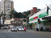
Today the road serves as a major link to the city from the predominantly upper and middle class suburbs of the Woollahra municipality. The road is often heavily congested with cars especially during peak hours. The road is serviced by a number of bus routes including the 324, 325, 326, 327, L24 and the sightseeing bus 222. There is a major bus depot and train station located on the road in Edgecliff. The Watson’s Bay Ferry Route has stops off the road in Rose Bay and Double Bay, providing a popular and quicker option for businesspersons in the area to commute to the city. The road also serves as the major leg of the Sydney City to SurfCity to Surf
City2Surf is a popular road running event held annually in Sydney, Australia covering a course. The event is a "fun run" as well as a race, attracting both serious runners and community participants who can choose to run or to walk...
running event, and is famous for the steep ascent from Rose Bay to Vaucluse known as Heartbreak Hill.