
Wynyard railway station, Sydney
Encyclopedia
Wynyard is a major underground CityRail
station in the central business district
of Sydney, Australia, 2.05 km from Central
. Wynyard averages 108000 passenger movements per day Monday to Friday.
, and in the interim were used as a terminus for North Shore tram services on Sydney's original tram network
, a service that operated over those tracks from the bridge's opening in 1932 until 1958. A feature of these lines was Australia's only underground tram terminus. After these tram services were withdrawn, the space occupied by platforms 1 and 2 was converted into the current underground car park, and the eastern tram tracks on the bridge were replaced by two extra road lanes. The disused tunnel and ramp that formerly connected the station to the eastern tram tracks can still be seen, mirroring those still in use to the west of the bridge.
The station was linked to the City Circle
on 22 January 1956.
line, whilst the lower level serves lines traversing the City Circle
. Both lines run south under York Street from Wynyard to Town Hall. There is no connection between the rails of these two lines at Wynyard.
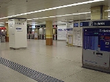
The passenger concourse is on an intermediate level between the upper and lower platforms. Wynyard is connected via underground passageways to several surrounding buildings and shopping arcades and is located immediately below Wynyard Park
. Direct access via tunnels is possible to George Street
, Hunter Street, Pitt Street
, Clarence Street and Kent Street. Escalators connect the station concourse with York Street (emerging underneath Transport House) and Carrington Street (under Wynyard Park).
The station is equipped with Easy Access for wheelchairs.
It has two NewsLink
stores, George Street Concourse and York Street Concourse.
trains of several lines: the North Shore
line, the Northern
line and the lines served by the City Circle
, namely the Bankstown Line, the Airport & East Hills Line, and the Southern Line
. Although there were stairs between former Platforms 1 and 2 and platforms 5 and 6 (which are still in existence, although boarded up), the only access between platforms is via the concourse.
The station is served by twelve to sixteen trains per hour each way, with additional trains during weekday peak hours.
The services are:
 Above the railway station is the Sydney Buses Wynyard station terminus. A large number of Sydney Buses services originate from this stop. They are:
Stand A:
Stand B:
Stand C:
Stand D:
Stand E:
Stand F:
Stand G:
Stand H:
Stand J:
Stand K:
Stand L:
Stand M:
Stand P:
Stand R:
Stand T:
Bus Timetables and Route Maps are available at http://www.sydneybuses.info/timetables.htm
CityRail
CityRail is an operating brand of RailCorp, a corporation owned by the state government of New South Wales, Australia. It is responsible for providing commuter rail services, and some coach services, in and around Sydney, Newcastle and Wollongong, the three largest cities of New South Wales. It is...
station in the central business district
Central business district
A central business district is the commercial and often geographic heart of a city. In North America this part of a city is commonly referred to as "downtown" or "city center"...
of Sydney, Australia, 2.05 km from Central
Central railway station, Sydney
Central Railway Station, the largest railway station in Australia, is at the southern end of the Sydney CBD. It services almost all the lines on the CityRail network, and is the major terminus for interurban and interstate rail services...
. Wynyard averages 108000 passenger movements per day Monday to Friday.
History
The station opened on 28 February 1932. Wynyard was originally constructed with six platforms (the existing four platforms are still numbered from 3 to 6.) The original intention was that Platforms 1 and 2 would eventually serve the eastern pair of railway tracks across Sydney Harbour BridgeSydney Harbour Bridge
The Sydney Harbour Bridge is a steel through arch bridge across Sydney Harbour that carries rail, vehicular, bicycle and pedestrian traffic between the Sydney central business district and the North Shore. The dramatic view of the bridge, the harbour, and the nearby Sydney Opera House is an iconic...
, and in the interim were used as a terminus for North Shore tram services on Sydney's original tram network
Trams in Sydney
The Sydney tramway network once served Sydney, the capital city of New South Wales, Australia. In its heyday, it was the largest in Australia, the second largest in the Commonwealth , and one of the largest in the world. It was extremely intensively worked, with about 1,600 cars in service at any...
, a service that operated over those tracks from the bridge's opening in 1932 until 1958. A feature of these lines was Australia's only underground tram terminus. After these tram services were withdrawn, the space occupied by platforms 1 and 2 was converted into the current underground car park, and the eastern tram tracks on the bridge were replaced by two extra road lanes. The disused tunnel and ramp that formerly connected the station to the eastern tram tracks can still be seen, mirroring those still in use to the west of the bridge.
The station was linked to the City Circle
City Circle
The City Circle is a system of largely underground passenger railway lines located in the central business district of Sydney, New South Wales, Australia, that make up the heart of the Sydney passenger railway network. The lines are owned by RailCorp, a New South Wales government agency, and...
on 22 January 1956.
Station configuration
Wynyard station currently has two levels, each with two platforms. The upper level serves the North ShoreNorth Shore Line
North Shore Line could refer to one of several railway lines:* Chicago North Shore and Milwaukee Railroad, United States* North Shore railway line, Sydney, Australia* North Shore Line , a former trolley line on the north shore of Long Island...
line, whilst the lower level serves lines traversing the City Circle
City Circle
The City Circle is a system of largely underground passenger railway lines located in the central business district of Sydney, New South Wales, Australia, that make up the heart of the Sydney passenger railway network. The lines are owned by RailCorp, a New South Wales government agency, and...
. Both lines run south under York Street from Wynyard to Town Hall. There is no connection between the rails of these two lines at Wynyard.
The passenger concourse is on an intermediate level between the upper and lower platforms. Wynyard is connected via underground passageways to several surrounding buildings and shopping arcades and is located immediately below Wynyard Park
Wynyard Park, Sydney
Wynyard Park is a small park in the city of Sydney, New South Wales, Australia. Wynyard Park is located in the Sydney central business district and is bounded by York , Carrington, Margaret and Barrack Streets. Surrounded by modern high-rise buildings it is one of the most densely built-up and...
. Direct access via tunnels is possible to George Street
George Street, Sydney
George Street is one of Sydney's most notable city streets. There are more high rise buildings and more ASX 100 companies located here than anywhere else in Australia, and is well known for being busy around-the-clock...
, Hunter Street, Pitt Street
Pitt Street, Sydney
Pitt Street is a major street in central Sydney, New South Wales, Australia. The street runs through the entire city centre from Circular Quay in the north to Waterloo, although today's street is in two disjointed sections after a substantial stretch of it was removed to make way for Sydney's...
, Clarence Street and Kent Street. Escalators connect the station concourse with York Street (emerging underneath Transport House) and Carrington Street (under Wynyard Park).
The station is equipped with Easy Access for wheelchairs.
It has two NewsLink
NewsLink
NewsLink Pty Ltd is an Australian company responsible for providing convenience items and travel products in airports and train stations in Australia, China, Hong Kong, Singapore, Taiwan, and Fiji.-History:NewsLink began in 1990 when its founder, Roger Wood obtained the rights to operate...
stores, George Street Concourse and York Street Concourse.
Platforms and services
The station services the CityRailCityRail
CityRail is an operating brand of RailCorp, a corporation owned by the state government of New South Wales, Australia. It is responsible for providing commuter rail services, and some coach services, in and around Sydney, Newcastle and Wollongong, the three largest cities of New South Wales. It is...
trains of several lines: the North Shore
North Shore Line
North Shore Line could refer to one of several railway lines:* Chicago North Shore and Milwaukee Railroad, United States* North Shore railway line, Sydney, Australia* North Shore Line , a former trolley line on the north shore of Long Island...
line, the Northern
Northern railway line, Sydney
The Northern Line is part of the metropolitan rail network in Sydney known as CityRail. It serves the northern suburbs of Sydney and the Lower North Shore, along with parts of the Inner West and the Hills District. The line utilises the Epping to Chatswood Line and parts of the Main Northern Line,...
line and the lines served by the City Circle
City Circle
The City Circle is a system of largely underground passenger railway lines located in the central business district of Sydney, New South Wales, Australia, that make up the heart of the Sydney passenger railway network. The lines are owned by RailCorp, a New South Wales government agency, and...
, namely the Bankstown Line, the Airport & East Hills Line, and the Southern Line
South railway line, Sydney
The South Line is a railway line in Sydney, New South Wales, Australia, and is part of the CityRail suburban network...
. Although there were stairs between former Platforms 1 and 2 and platforms 5 and 6 (which are still in existence, although boarded up), the only access between platforms is via the concourse.
The station is served by twelve to sixteen trains per hour each way, with additional trains during weekday peak hours.
The services are:
Bus services
Stand A:
- 243 - to Spit JunctionSpit Junction, New South WalesSpit Junction is an urban locality in the suburb of Mosman in Sydney, New South Wales, Australia. Spit Junction is located in the local government area of the Municipality of Mosman and is part of the Lower North Shore.-History:...
- (Brady Street near Military Road) - 244 - to Chowder Bay - (Chowder Bay Road)
- 245 - to BalmoralBalmoral, New South WalesBalmoral is an urban locality in the suburb of Mosman in Sydney, New South Wales, Australia. Balmoral is located in the local government area of the Municipality of Mosman and is part of the Lower North Shore....
- (The Esplanade near Mandalong Road) - 246 - to Balmoral Heights
- 247 - to Taronga ZooTaronga ZooTaronga Zoo is the city zoo of Sydney, New South Wales, Australia. Officially opened on 7 October 1916, it is located on the shores of Sydney Harbour in the suburb of Mosman...
- (Athol Wharf Road) - 249 - to Beauty PointBeauty Point, New South WalesBeauty Point is an urban locality in the suburb of Mosman in Sydney, New South Wales, Australia. It is located in the local government area of the Municipality of Mosman and is part of the Lower North Shore.-History:...
- (Pearl Bay Road Terminus)
Stand B:
- 111 - Sydney Explorer tourist bus (inbound)
- 222 - Bondi Explorer tourist bus (outbound)
Stand C:
- 151 - to Mona ValeMona Vale, New South WalesMona Vale is a suburb in northern Sydney, in the state of New South Wales, Australia. It is located 28 kilometres north of the Sydney central business district and is the administrative centre of the local government area of Pittwater Council. Mona Vale is also part of the Northern Beaches region.-...
- (Darley Street near Mona Vale Bus Depot) - 183 - to North NarrabeenNorth Narrabeen, New South WalesNorth Narrabeen is a suburb in northern Sydney, in the state of New South Wales, Australia. North Narrabeen is located 25 kilometres north of the Sydney central business district, in the local government area of Pittwater Council...
- (Namona Street near Oak Street) - E83 - to NarrabeenNarrabeen, New South WalesNarrabeen is a beachside suburb in northern Sydney, in the state of New South Wales, Australia. Narrabeen is located 23 kilometres north-east of the Sydney central business district, in the local government area of Warringah Council and is part of the Northern Beaches region.-History:There are a...
- (Pittwater Road near Waterloo Street) - 184 - to Mona ValeMona Vale, New South WalesMona Vale is a suburb in northern Sydney, in the state of New South Wales, Australia. It is located 28 kilometres north of the Sydney central business district and is the administrative centre of the local government area of Pittwater Council. Mona Vale is also part of the Northern Beaches region.-...
- (Darley Street near Mona Vale Bus Depot) - E84 - to Mona ValeMona Vale, New South WalesMona Vale is a suburb in northern Sydney, in the state of New South Wales, Australia. It is located 28 kilometres north of the Sydney central business district and is the administrative centre of the local government area of Pittwater Council. Mona Vale is also part of the Northern Beaches region.-...
- (Darley Street near Mona Vale Bus Depot) - 185 - to Mona ValeMona Vale, New South WalesMona Vale is a suburb in northern Sydney, in the state of New South Wales, Australia. It is located 28 kilometres north of the Sydney central business district and is the administrative centre of the local government area of Pittwater Council. Mona Vale is also part of the Northern Beaches region.-...
- (Darley Street near Mona Vale Bus Depot) - L85 - to Mona ValeMona Vale, New South WalesMona Vale is a suburb in northern Sydney, in the state of New South Wales, Australia. It is located 28 kilometres north of the Sydney central business district and is the administrative centre of the local government area of Pittwater Council. Mona Vale is also part of the Northern Beaches region.-...
- (Darley Street near Mona Vale Bus Depot) - 188 - to AvalonAvalon, New South WalesAvalon is a northern beachside suburb of Sydney, in the state of New South Wales, Australia. Avalon is located 35 kilometres north of the Sydney central business district, in the local government area of Pittwater Council, in the Northern Beaches region....
- (Barrenjoey Road near Avalon Parade) - L88 - to AvalonAvalon, New South WalesAvalon is a northern beachside suburb of Sydney, in the state of New South Wales, Australia. Avalon is located 35 kilometres north of the Sydney central business district, in the local government area of Pittwater Council, in the Northern Beaches region....
- (Carreel Head Road near Burrawong Road) - 190 - to Palm BeachPalm Beach, New South WalesPalm Beach is a northern beachside suburb of Sydney, in the state of New South Wales, Australia. Palm Beach is located 41 kilometres north of the Sydney central business district, in the local government area of Pittwater Council, in the Northern Beaches region. Palm Beach sits on a peninsula at...
- (Ocean Place near Ocean Road) - L90 - to Palm BeachPalm Beach, New South WalesPalm Beach is a northern beachside suburb of Sydney, in the state of New South Wales, Australia. Palm Beach is located 41 kilometres north of the Sydney central business district, in the local government area of Pittwater Council, in the Northern Beaches region. Palm Beach sits on a peninsula at...
- (Ocean Place near Ocean Road)
Stand D:
- E76 - to Dee WhyDee Why, New South WalesDee Why is a suburb of northern Sydney, in the state of New South Wales, Australia. Dee Why is located 18 kilometres north-east of the Sydney central business district and is the administrative centre of the local government area of Warringah Council, and along with Brookvale is considered to be...
- (Howard Avenue near Avon Road) - E77 - to Dee WhyDee Why, New South WalesDee Why is a suburb of northern Sydney, in the state of New South Wales, Australia. Dee Why is located 18 kilometres north-east of the Sydney central business district and is the administrative centre of the local government area of Warringah Council, and along with Brookvale is considered to be...
- (Pacific Parade near Sturdee Parade) - 178 - to Cromer Heights
- E78 - to Cromer Heights
- 179 - to Collaroy PlateauCollaroy Plateau, New South WalesCollaroy Plateau is a suburb of northern Sydney, in the state of New South Wales, Australia. Collaroy Plateau is located 22 kilometres north-east of the Sydney central business district, in the local government area of Warringah Council and is part of the Northern Beaches region.Collaroy Plateau...
- (Lantana Avenue near War Veterans Home) - E79 - to Collaroy PlateauCollaroy Plateau, New South WalesCollaroy Plateau is a suburb of northern Sydney, in the state of New South Wales, Australia. Collaroy Plateau is located 22 kilometres north-east of the Sydney central business district, in the local government area of Warringah Council and is part of the Northern Beaches region.Collaroy Plateau...
- (Lantana Avenue near War Veterans Home) - 180 - to Collaroy PlateauCollaroy Plateau, New South WalesCollaroy Plateau is a suburb of northern Sydney, in the state of New South Wales, Australia. Collaroy Plateau is located 22 kilometres north-east of the Sydney central business district, in the local government area of Warringah Council and is part of the Northern Beaches region.Collaroy Plateau...
- (Hall Avenue near Heather Street) - L80 - to Collaroy PlateauCollaroy Plateau, New South WalesCollaroy Plateau is a suburb of northern Sydney, in the state of New South Wales, Australia. Collaroy Plateau is located 22 kilometres north-east of the Sydney central business district, in the local government area of Warringah Council and is part of the Northern Beaches region.Collaroy Plateau...
- (Hall Avenue near Heather Street)
Stand E:
- 169 - to Manly Wharf - (West Esplanade Stand B)
- E69 - to Manly Wharf - (West Esplanade Stand B).
Stand F:
- 202 - to NorthbridgeNorthbridge, New South WalesNorthbridge is a suburb on the lower North Shore of Sydney, New South Wales, Australia. Northbridge is located 7 kilometres north of the Sydney central business district, in the local government area of Willoughby....
- (Sailors Bay Road near Tycannah Road) - 203 - to CastlecragCastlecrag, New South WalesCastlecrag is a suburb on the lower North Shore of Sydney, in the state of New South Wales, Australia. Castlecrag is located 8 kilometres north of the Sydney central business district, in the local government area of the City of Willoughby....
- (Edinburgh Road Terminus) - 207 - to East LindfieldEast Lindfield, New South WalesEast Lindfield is a locality on the Upper North Shore of Sydney in the state of New South Wales, Australia. East Lindfield is located 13 kilometres north-west of the Sydney Central Business District in the local government area of Ku-ring-gai Council....
- (Ulmarra Place) - 208 - to East LindfieldEast Lindfield, New South WalesEast Lindfield is a locality on the Upper North Shore of Sydney in the state of New South Wales, Australia. East Lindfield is located 13 kilometres north-west of the Sydney Central Business District in the local government area of Ku-ring-gai Council....
- (Tryon Road near East Lindfield Primary School)
Stand G:
- 273 - to Chatswood station Interchange Set Down
Stand H:
- 201 - to CremorneCremorne, New South WalesCremorne is a suburb on the lower North Shore of Sydney, New South Wales, Australia. Cremorne is located 6 kilometres north of the Sydney central business district, in the local government area of North Sydney Council....
- (Benelong Road near Brightmore Street) - 263 - to Crows NestCrows Nest, New South WalesCrows Nest is a suburb on the lower North Shore of Sydney, New South Wales, Australia. Crows Nest is located 5 kilometres north of the Sydney central business district, in the local government area of North Sydney Council.-History:...
- (Burlington Street Stand 4)
Stand J:
- M20 - to BotanyBotany, New South WalesBotany is a suburb in south-eastern Sydney, in the state of New South Wales, Australia. Botany is located 10 kilometres south of the Sydney central business district and is part of the City of Botany Bay....
- (Botany Road near Banksia Street) - M30 - to SydenhamSydenham, New South WalesFor other places called Sydenham, see Sydenham .Sydenham is a small suburb in the inner-west of Sydney, in the state of New South Wales, Australia. Sydenham is located 8 kilometres south of Sydney central business district and is part of the local government area of Marrickville Council...
- (Sydenham railway Station) - M40 - to Bondi JunctionBondi Junction, New South WalesBondi Junction is an eastern suburb of Sydney, in the state of New South Wales, Australia. Bondi Junction is located 6 kilometres east of the Sydney central business district and is part of the local government area of the Waverley....
- (Bondi Junction Interchange)
Stand K:
- 204 - to NorthbridgeNorthbridge, New South WalesNorthbridge is a suburb on the lower North Shore of Sydney, New South Wales, Australia. Northbridge is located 7 kilometres north of the Sydney central business district, in the local government area of Willoughby....
- (Sailors Bay Road near Tycannah Road) - 205 - to WilloughbyWilloughby, New South WalesWilloughby is a suburb on the lower North Shore of Sydney, in the state of New South Wales, Australia. Willoughby is located 8 kilometres north of the Sydney central business district, in the local government area of the City of Willoughby....
- (Stan Street near Willoughby Bus Depot) - 206 - to East LindfieldEast Lindfield, New South WalesEast Lindfield is a locality on the Upper North Shore of Sydney in the state of New South Wales, Australia. East Lindfield is located 13 kilometres north-west of the Sydney Central Business District in the local government area of Ku-ring-gai Council....
- (Ulmarra Place) - 210 - to East LindfieldEast Lindfield, New South WalesEast Lindfield is a locality on the Upper North Shore of Sydney in the state of New South Wales, Australia. East Lindfield is located 13 kilometres north-west of the Sydney Central Business District in the local government area of Ku-ring-gai Council....
- (Ulmarra Place)
Stand L:
- E65 - to Curl CurlCurl Curl, New South WalesCurl Curl is a suburb of northern Sydney in the state of New South Wales, Australia. Curl Curl is located 18 kilometres north-east of the Sydney central business district, in the local government area of Warringah Council and is part of the Northern Beaches region...
- (Carrington Parade near Gardere Avenue) - E66 - to Frenchs ForestFrenchs Forest, New South Wales-Commercial areas:Forestway shopping centre is at the intersection of Forestway and Warringah Roads. During the 1960s and 1970s, this centre had the name Arndale...
- (Allambie Road near Frenchs Forest Road)
Stand M:
- 168 - to BrookvaleBrookvale, New South WalesBrookvale is a suburb of northern Sydney, in the state of New South Wales, Australia. Brookvale is located 16 kilometres north-east of the Sydney central business district, in the local government area of Warringah Council and is part of the Northern Beaches region.-History:The first development in...
- (Pittwater Road near Bus Depot) - E68 - to BrookvaleBrookvale, New South WalesBrookvale is a suburb of northern Sydney, in the state of New South Wales, Australia. Brookvale is located 16 kilometres north-east of the Sydney central business district, in the local government area of Warringah Council and is part of the Northern Beaches region.-History:The first development in...
- (Pittwater Road near Bus Depot) - E70 - to ManlyManly, New South WalesManly is a suburb of northern Sydney, in the state of New South Wales, Australia. Manly is located 17 kilometres north-east of the Sydney central business district and is the administrative centre of the local government area of Manly Council, in the Northern Beaches region.-History:Manly was named...
- (Gilbert Street near Belgrave Street) - 171 - to Manly Wharf - (West Esplanade near Belgrave Street)
- E71 - to Manly Wharf - (West Esplanade near Belgrave Street)
Stand P:
- 272 - to North WilloughbyNorth Willoughby, New South WalesNorth Willoughby is a suburb on the lower North Shore of Sydney, in the state of New South Wales, Australia. North Willoughby is located 9 kilometres north of the Sydney central business district, in the local government area of the City of Willoughby...
Interchange Set Down
Stand R:
- M20 - to Gore HillGore Hill, New South WalesGore Hill is an urban locality on the North Shore of Sydney, in the state of New South Wales, Australia. Gore Hill is located in the western part of the suburb of St Leonards....
- (Campbell Street near Reserve Road) - M40 - to ChatswoodChatswood, New South WalesChatswood is a suburb on the North Shore of Sydney, in the state of New South Wales, Australia. Chatswood is located 10 kilometres north of the Sydney central business district and is the administrative centre of the local government area of the City of Willoughby. Chatswood West is a separate suburb...
- (Chatswood Interchange)
Stand T:
- M30 - to Spit JunctionSpit Junction, New South WalesSpit Junction is an urban locality in the suburb of Mosman in Sydney, New South Wales, Australia. Spit Junction is located in the local government area of the Municipality of Mosman and is part of the Lower North Shore.-History:...
- (Military Road near Spit Road) - E86 - to Church PointChurch Point, New South WalesChurch Point is a suburb in northern Sydney, in the state of New South Wales, Australia. Church Point is located 32 kilometres north of the Sydney central business district, in the local government area of Pittwater Council and is part of the Northern Beaches region.-History:Thomas Langford was the...
- (Mccarrs Creek Terminus) - E87 - to NewportNewport, New South WalesNewport is a suburb in northern Sydney, in the state of New South Wales, Australia. Newport is located 31 kilometres north of the Sydney central business district, in the local government area of Pittwater Council, and is part of the Northern Beaches region....
- (Seaview Avenue near Robertson Road) - E88 - to AvalonAvalon, New South WalesAvalon is a northern beachside suburb of Sydney, in the state of New South Wales, Australia. Avalon is located 35 kilometres north of the Sydney central business district, in the local government area of Pittwater Council, in the Northern Beaches region....
- (Barrenjoey Road near Careel Head Road) - E89 - to AvalonAvalon, New South WalesAvalon is a northern beachside suburb of Sydney, in the state of New South Wales, Australia. Avalon is located 35 kilometres north of the Sydney central business district, in the local government area of Pittwater Council, in the Northern Beaches region....
- (Barrenjoey Road near Avalon Parade)
Bus Timetables and Route Maps are available at http://www.sydneybuses.info/timetables.htm
Neighbouring stations
External links
- Leungy's Rail Gallery - pictures of the former tram platforms 1 & 2 and the connecting tunnels, now converted into a two-storey carpark.
- Neety's Train Page - station information
- New South Wales Railways - station information