
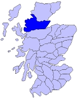
Ross
Encyclopedia

Scotland
Scotland is a country that is part of the United Kingdom. Occupying the northern third of the island of Great Britain, it shares a border with England to the south and is bounded by the North Sea to the east, the Atlantic Ocean to the north and west, and the North Channel and Irish Sea to the...
and a former mormaer
Mormaer
The title of Mormaer designates a regional or provincial ruler in the medieval Kingdom of the Scots. In theory, although not always in practice, a Mormaer was second only to the King of Scots, and the senior of a toisech.-Origin:...
dom, earldom, sheriffdom
Sheriffdom
A sheriffdom is a judicial district in Scotland.Since 1 January 1975 there have been six sheriffdoms. Previously sheriffdoms were composed of groupings of counties...
and county
Counties of Scotland
The counties of Scotland were the principal local government divisions of Scotland until 1975. Scotland's current lieutenancy areas and registration counties are largely based on them. They are often referred to as historic counties....
. The name Ross allegedly derives from a Gaelic word meaning a headland - perhaps a reference to the Black Isle
Black Isle
The Black Isle is an eastern area of the Highland local government council area of Scotland, within the county of Ross and Cromarty. The name nearly always includes the article "the"....
. The Norse word for Orkney - Hrossay meaning horse island - is another possible origin. The area once belonged to the Norse earldom of Orkney. Ross is a historical comital region, perhaps predating the Mormaerdom of Ross.
History
Excavations of a rock shelter and shell middenMidden
A midden, is an old dump for domestic waste which may consist of animal bone, human excrement, botanical material, vermin, shells, sherds, lithics , and other artifacts and ecofacts associated with past human occupation...
at Sand, Applecross
Sand, Applecross
Sand on the Applecross Peninsula in Wester Ross, Scotland is a major archaeological site.Sand is the site of a major archaeological excavation on the Inner Sound coast of the Applecross Peninsula in Western Scotland, to the north of the small town of Applecross.A small number of shell middens were...
on the coast of Western Ross have shown that the coast was occupied by Mesolithic
Mesolithic
The Mesolithic is an archaeological concept used to refer to certain groups of archaeological cultures defined as falling between the Paleolithic and the Neolithic....
hunter-gatherers.
It may be doubted whether the Roman
Roman Empire
The Roman Empire was the post-Republican period of the ancient Roman civilization, characterised by an autocratic form of government and large territorial holdings in Europe and around the Mediterranean....
s ever effected even a temporary settlement in the area of the modern county. In Roman times, and for long afterwards, the land was occupied by Gaelic Picts
Picts
The Picts were a group of Late Iron Age and Early Mediaeval people living in what is now eastern and northern Scotland. There is an association with the distribution of brochs, place names beginning 'Pit-', for instance Pitlochry, and Pictish stones. They are recorded from before the Roman conquest...
, who, in the 6th and 7th centuries, were converted to Christianity
Christianization
The historical phenomenon of Christianization is the conversion of individuals to Christianity or the conversion of entire peoples at once...
by followers of Saint Columba
Columba
Saint Columba —also known as Colum Cille , Colm Cille , Calum Cille and Kolban or Kolbjørn —was a Gaelic Irish missionary monk who propagated Christianity among the Picts during the Early Medieval Period...
. Throughout the next three centuries the natives were continually harassed by Norse
Viking
The term Viking is customarily used to refer to the Norse explorers, warriors, merchants, and pirates who raided, traded, explored and settled in wide areas of Europe, Asia and the North Atlantic islands from the late 8th to the mid-11th century.These Norsemen used their famed longships to...
raiders, of whose presence tokens have survived in several place-names (Dingwall
Dingwall
Dingwall is a town and former royal burgh in the Highland council area of Scotland. It has a population of 5,026. It was formerly an east-coast harbor but now lies inland. Dingwall Castle was once the biggest castle north of Stirling. On the town's present-day outskirts lies Tulloch Castle, parts...
, Tain
Tain
Tain is a royal burgh and post town in the committee area of Ross and Cromarty, in the Highland area of Scotland.-Etymology:...
, and others). At this time the country formed part of the great province of Moray
Moray
Moray is one of the 32 council areas of Scotland. It lies in the north-east of the country, with coastline on the Moray Firth, and borders the council areas of Aberdeenshire and Highland.- History :...
(Latin: Moravia), which then extended as far west as the Dornoch Firth
Dornoch Firth
The Dornoch Firth is a firth on the east coast of Highland, in northern Scotland. It forms part of the boundary between Ross and Cromarty, to the south, and Sutherland, to the north....
and the Oykel, and practically comprised the whole of Ross and Cromarty.
William, the 4th Earl of Ross
Earl of Ross
The Mormaer or Earl of Ross was the leader of a medieval Gaelic lordship in northern Scotland, roughly between the River Oykel and the River Beauly.-Origins and transfers:...
, was present with his clan
Scottish clan
Scottish clans , give a sense of identity and shared descent to people in Scotland and to their relations throughout the world, with a formal structure of Clan Chiefs recognised by the court of the Lord Lyon, King of Arms which acts as an authority concerning matters of heraldry and Coat of Arms...
at the Battle of Bannockburn
Battle of Bannockburn
The Battle of Bannockburn was a significant Scottish victory in the Wars of Scottish Independence...
(1314), and almost a century later (1412) the castle of Dingwall, the chief seat on the mainland of Donald, Lord of the Isles
Lord of the Isles
The designation Lord of the Isles is today a title of Scottish nobility with historical roots that go back beyond the Kingdom of Scotland. It emerged from a series of hybrid Viking/Gaelic rulers of the west coast and islands of Scotland in the Middle Ages, who wielded sea-power with fleets of...
, was captured after the disastrous fight at Harlaw
Battle of Harlaw
The Battle of Harlaw was a Scottish clan battle fought on 24 July 1411 just north of Inverurie in Aberdeenshire. It was one of a series of battles fought during the Middle Ages between the barons of northeast Scotland against those from the west coast....
in Aberdeenshire, which Donald had provoked when his claim to the earldom was rejected. The earldom reverted to the crown in 1424, but James I
James I of Scotland
James I, King of Scots , was the son of Robert III and Annabella Drummond. He was probably born in late July 1394 in Dunfermline as youngest of three sons...
soon afterwards restored it to the heiress of the line, the mother of Alexander Macdonald, 3rd Lord of the Isles
Lord of the Isles
The designation Lord of the Isles is today a title of Scottish nobility with historical roots that go back beyond the Kingdom of Scotland. It emerged from a series of hybrid Viking/Gaelic rulers of the west coast and islands of Scotland in the Middle Ages, who wielded sea-power with fleets of...
, who thus became the 11th Earl. In consequence, however, of the treason of John Macdonald, 4th and last Lord of the Isles and 12th Earl of Ross, the earldom was again vested in the crown (1476). Five years later James III
James III of Scotland
James III was King of Scots from 1460 to 1488. James was an unpopular and ineffective monarch owing to an unwillingness to administer justice fairly, a policy of pursuing alliance with the Kingdom of England, and a disastrous relationship with nearly all his extended family.His reputation as the...
bestowed it on his second son, James Stewart
James Stewart, Duke of Ross
James Stewart, Duke of Ross was the son of King James III of Scotland and Margaret of Denmark.-Titles and Offices:He was made Marquess of Ormond at his baptism...
, whom he also created Duke of Ross in 1488.
By the 16th century the whole area of the county was occupied by different clans
Scottish clan
Scottish clans , give a sense of identity and shared descent to people in Scotland and to their relations throughout the world, with a formal structure of Clan Chiefs recognised by the court of the Lord Lyon, King of Arms which acts as an authority concerning matters of heraldry and Coat of Arms...
. The Rosses held what is now Easter Ross; the Munros the small tract around Ben Wyvis, including Dingwall; the Macleods Lewis
Lewis
Lewis is the northern part of Lewis and Harris, the largest island of the Western Isles or Outer Hebrides of Scotland. The total area of Lewis is ....
, and, in the mainland, the district between Loch Maree and Loch Torridon; the Macdonalds of Glengarry, Coigach, and the district between Strome Ferry and Kyle of Lochalsh, and the Mackenzies the remainder.
The county of Ross was constituted in 1661, and Cromarty in 1685 and 1698, both being consolidated into the present county in 1889.
Apart from occasional conflicts between rival clans, the only battle
Battle
Generally, a battle is a conceptual component in the hierarchy of combat in warfare between two or more armed forces, or combatants. In a battle, each combatant will seek to defeat the others, with defeat determined by the conditions of a military campaign...
s in the county were Invercarron, at the head of Dornoch Firth, when Montrose was crushed by Colonel Archibald Strachan on 27 April 1650—and the Battle of Glenshiel, when the Jacobites
Jacobitism
Jacobitism was the political movement in Britain dedicated to the restoration of the Stuart kings to the thrones of England, Scotland, later the Kingdom of Great Britain, and the Kingdom of Ireland...
, under the Earl of Seaforth
William Mackenzie, 5th Earl of Seaforth
William Mackenzie, 5th Earl of Seaforth was a Scottish nobleman.He who joined the Jacobite standard at Braemar, during the rising of 1715, and then, having raised 3000 men, was present at the battle of Sheriffmuir and was appointed lieutenant-general of the northern counties...
, aided by Spaniards, were defeated by a force under the command of General Joseph Wightman on 10 June 1719.
Geography
Sutherland
Sutherland is a registration county, lieutenancy area and historic administrative county of Scotland. It is now within the Highland local government area. In Gaelic the area is referred to according to its traditional areas: Dùthaich 'IcAoidh , Asainte , and Cataibh...
and the Dornoch Firth, west of the North Sea
North Sea
In the southwest, beyond the Straits of Dover, the North Sea becomes the English Channel connecting to the Atlantic Ocean. In the east, it connects to the Baltic Sea via the Skagerrak and Kattegat, narrow straits that separate Denmark from Norway and Sweden respectively...
and the Moray Firth
Moray Firth
The Moray Firth is a roughly triangular inlet of the North Sea, north and east of Inverness, which is in the Highland council area of north of Scotland...
, north of the Beauly Firth
Beauly Firth
The Beauly Firth is a firth in northern Scotland. It is effectively a continuation of the Moray Firth westward, and is bounded at one end by Beauly and at the other by Inverness . The Kessock Ferry has crossed at the eastern end since the 15th Century...
and Inverness-shire
Inverness-shire
The County of Inverness or Inverness-shire was a general purpose county of Scotland, with the burgh of Inverness as the county town, until 1975, when, under the Local Government Act 1973, the county area was divided between the two-tier Highland region and the unitary Western Isles. The Highland...
and east of The Minch
The Minch
The Minch , also called The North Minch, is a strait in north-west Scotland, separating the north-west Highlands, and the northern Inner Hebrides, from Lewis and Harris in the Outer Hebrides...
. There are also a number of small islands off the area's west coast, among which are:
- Gillean (lighthouse) in the parish of Lochalsh
- Crowlin IslandsCrowlin IslandsThe Crowlin Islands are a group of uninhabited islands in the Inner Hebrides of Scotland. They lie between Skye and the Applecross peninsula on the mainland.The individual islands are:*Eilean Mòr *Eilean Meadhonach...
in ApplecrossApplecrossThe Applecross peninsula is a peninsula in Wester Ross, Highland, on the west coast of Scotland. The name Applecross is at least 1300 years old and is not used locally to refer to the 19th century village with the pub and post office, lying on the small Applecross Bay, facing the Inner Sound, on... - Eilean HorrisdaleEilean HorrisdaleEilean Horrisdale is an uninhabited island in Loch Gairloch in Wester Ross, Scotland.-Geography:Eilean Horrisdale is the largest island in Loch Gairloch. In front is the smaller, Eilean Tioram , which is connected to the mainland by a causeway....
, and Isle of EweIsle of EweIsle of Ewe is a small Scottish island on the west coast of Ross and Cromarty.-Geography and geology:The Isle of Ewe is located in Loch Ewe, west of Aultbea in the Ross and Cromarty district of the Highland Region. The island is made up of sandstone and the shore line varies from flat pebble...
in GairlochGairlochGairloch is a village, civil parish and community on the shores of Loch Gairloch on the northwest coast of Scotland. A popular tourist destination in the summer months, Gairloch has a golf course, a small museum, several hotels, a community centre, a leisure centre with sports facilities, a local...
parish - Isle MartinIsle MartinIsle Martin is an uninhabited island in Loch Broom, on the west coast of Scotland. It is the closest of the Summer Isles to Ullapool and has been the site of a monastery, a herring curing station and a flour mill. Now recognised as a bird sanctuary it is owned and managed by a community...
and Tanera More, of the Summer IslesSummer IslesThe Summer Isles are an archipelago lying in the mouth of Loch Broom, in the Highland region of Scotland.-Geography:The only inhabited isle, Tanera Mòr, is also the largest. It is home to an Atlantic salmon fish farm, some rental holiday homes, a café and a post office, which has operated its own...
group in the parish of Lochbroom
The area of the mainland comprises 1572332 acres (636,300.7 ha).
On the North Sea (eastern side) of the area the major firth
Firth
Firth is the word in the Lowland Scots language and in English used to denote various coastal waters in Scotland and England. In mainland Scotland it is used to describe a large sea bay, or even a strait. In the Northern Isles it more usually refers to a smaller inlet...
s are the Beauly Firth and the (Inner) Moray Firth
Moray Firth
The Moray Firth is a roughly triangular inlet of the North Sea, north and east of Inverness, which is in the Highland council area of north of Scotland...
, which mark off the Black Isle
Black Isle
The Black Isle is an eastern area of the Highland local government council area of Scotland, within the county of Ross and Cromarty. The name nearly always includes the article "the"....
from Inverness-shire
Inverness-shire
The County of Inverness or Inverness-shire was a general purpose county of Scotland, with the burgh of Inverness as the county town, until 1975, when, under the Local Government Act 1973, the county area was divided between the two-tier Highland region and the unitary Western Isles. The Highland...
, the Cromarty Firth
Cromarty Firth
The Cromarty Firth of Cromarty') is an arm of the North Sea in Scotland. It is the middle of the three sea lochs at the head of the Moray Firth: to the north lies the Dornoch Firth, and to the south the Beauly Firth....
, which bounds the districts of Easter Ross and the Black Isle, the Moray Firth, separating Easter Ross from Nairnshire, and the Dornoch Firth
Dornoch Firth
The Dornoch Firth is a firth on the east coast of Highland, in northern Scotland. It forms part of the boundary between Ross and Cromarty, to the south, and Sutherland, to the north....
, dividing north-east Ross
Ross-shire
Ross-shire is an area in the Highland Council Area in Scotland. The name is now used as a geographic or cultural term, equivalent to Ross. Until 1889 the term denoted a county of Scotland, also known as the County of Ross...
from Sutherland.
On the Atlantic (western) coastline—which has a length of nearly 311 miles (500.5 km)—the principal sea lochs and bays, from south to north, include Loch Duich
Loch Duich
Loch Duich is a sea loch situated on the western coast of Scotland, in the Highlands.-History:In 1719, British forces burned many homesteads along the loch’s shores in the month preceding the Battle of Glen Shiel....
, Loch Alsh
Loch Alsh
Loch Alsh or Lochalsh is a sea inlet between the isle of Skye in the Inner Hebrides and the Northwest Highlands of Scotland. The name is also used to described the surrounding country and the feudal holdings around the loch...
, Loch Carron, Loch Kishorn, Loch Torridon
Loch Torridon
Loch Torridon is a sea loch on the west coast of Scotland in the Northwest Highlands. The loch was created by glacial processes and is in total around 15 miles long. It has two sections: Upper Loch Torridon to landward, east of Rubha na h-Airde Ghlaise, at which point it joins Loch Sheildaig;...
, Loch Shieldaig, Upper Loch Torridon, Gair Loch, Loch Ewe
Loch Ewe
Loch Ewe is a sea loch in the region of in the Northwest Highlands of Scotland. The shores are inhabited by a traditionally Gàidhlig speaking people living in or sustained by crofting villages, the most notable of which, situated on the north-eastern shore, is the Aultbea settlement...
, Gruinard Bay
Gruinard Bay
Gruinard Bay is a large remote coastal embayment, located 12 miles north of Poolewe, in northwestern Ross and Cromarty, and is in the former parish of Lochbroom, in the west coast of Scotland.-Settlements:...
, Loch Broom
Loch Broom
Loch Broom is a sea loch located in northwestern Ross and Cromarty, in the former parish of Lochbroom, in the west coast of Scotland. The small town of Ullapool lies on the eastern shore of the loch...
and Enard Bay.
The chief capes include Tarbat Ness on the east coast, and Coigach, Greenstone Point, Rubha Reidh, Redpoint
Redpoint
Redpoint is a small settlement in the north west of Highland, Scotland. It takes its name from Red Point, a low promontory to the south, which marks a turn in the coastline from facing west to south east as it becomes Loch Torridon....
and Hamha Point on the west.
Almost all the southern boundary with Inverness-shire consists of a rampart of peaks, many of them Munro
Munro
A Munro is a mountain in Scotland with a height over . They are named after Sir Hugh Munro, 4th Baronet , who produced the first list of such hills, known as Munros Tables, in 1891. A Munro top is a summit over 3,000 ft which is not regarded as a separate mountain...
s:
- An RiabhachanAn RiabhachanAn Riabhachan is a Scottish mountain in the Skye and Lochalsh district of the Highland council area. It is situated 35 kilometres east of Kyle of Lochalsh standing in an isolated position at the western end of Loch Mullardoch, ten kilometres from any public road.- Overview :An Riabhachan reaches a...
(3704 ft (1,129 m)), - Sgurr na LapaichSgurr na LapaichSgurr na Lapaich is a mountain in the Northwest Highlands of Scotland, situated north of Loch Mullardoch in the high ground that separates Glen Cannich and Glen Strathfarrar. The mountain reaches a height of 1,150 metres , and is the fourth highest mountain north of the Great Glen...
(3773 ft (1,150 m)), - Carn EigeCarn EigeCàrn Eige, sometimes spelt Càrn Eighe, is the highest mountain in northern Scotland . It is in the Highland council area, on the boundary between the historic counties of Inverness and Ross and Cromarty, on the former lands of the Clan Chisholm.The mountain is very remote, more than 10 km ...
(Càrn Eighe) (3881 ft (1,182.9 m)), - Mam SodhailMam SodhailMam Sodhail, sometimes known by its anglicised name of "Mam Soul", is a Scottish Munro situated in the secluded country on the northern side of Glen Affric, some 30 kilometres east of Kyle of Lochalsh.- Overview :...
(Mam Soul) (3871 ft (1,179.9 m)), - Beinn FhadaBeinn FhadaBeinn Fhada or Ben Attow is a mountain in the Scottish Highlands.The finest route up Beinn Fhada is from Morvich to the north-west. There is a direct line up a grassy, and rather boggy slope, from the east side of the River Croe...
(Ben Attow) (3386 ft (1,032.1 m)), - Sgurr FhuaranSgurr FhuaranSgùrr Fhuaran is a Scottish mountain that is situated on the northern side of Glen Shiel, east south east of Kyle of Lochalsh.- Overview :...
(3504 ft (1,068 m)), - The SaddleThe SaddleThe Saddle is one of the great Scottish mountains; seen from thesite of the Battle of Glen Shiel it forms one of the best-known views in the Highlands. It is in the Highland local government area, on the boundary between the counties of Inverness-shire and Ross and Cromarty.The mountain provides...
(3317 ft (1,011 m)).
To the north of Glen Torridon
Torridon
Torridon is a small village in the Northwest Highlands of Scotland. However the name is also applied to the area surrounding the village, particularly the Torridon Hills, mountains to the north of Glen Torridon. It lies on the shore of Loch Torridon.Torridon is on the west coast of Scotland, ...
are the masses of Liathach
Liathach
Liathach is one of the most famous of the Torridon Hills. It lies to the north of the A896 road, in the Northwest Highlands of Scotland, and has two peaks of Munro status: Spidean a' Choire Leith at the east of the main ridge, and Mullach an Rathain at the western end of the mountain...
(3455 ft (1,053.1 m)), Beinn Eighe
Beinn Eighe
Beinn Eighe is a complex mountain massif in the Torridon area of the Highlands of Scotland. It forms a long ridge with many spurs and summits, two of which are classified as Munros. The name Beinn Eighe comes from the Scottish Gaelic meaning File Mountain...
(3313 ft (1,009.8 m)), Beinn Alligin
Beinn Alligin
Beinn Alligin one of the classic mountains of the Torridon region of Scotland, lying to the north of Loch Torridon, in the Highlands. The name Beinn Alligin is from the Scottish Gaelic, meaning Jewelled Hill...
(3235 ft (986 m)) and Beinn Dearg
Beinn Dearg (Torridon)
Beinn Dearg is the 4th highest of the Torridon mountains in the highlands of Scotland. Beinn Dearg offers all the typical features of a Torridon hill, with steeply terraced rocky sides dissected by near vertical gullies...
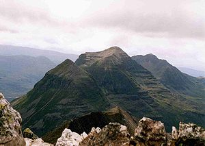
(2998 ft (913.8 m)). On the northeastern shore of Loch Maree rises Slioch
Slioch
Slioch is a mountain in the Scottish Highlands situated in Wester Ross, eight kilometres north of the village of Kinlochewe. Slioch reaches a height of 981 metres and towers above the south east end of Loch Maree to give one of the best known and most photographed sights in the Highlands...
(3219 ft (981.2 m)), while the Fannich group contains six Munros, the highest being Sgurr Mor (3645 ft (1,111 m)). The immense isolated bulk of Ben Wyvis
Ben Wyvis
Ben Wyvis is a mountain located in Easter Ross, Ross and Cromarty, Highland, in northern Scotland, north-west of Dingwall. It forms an undulating ridge running roughly north-south for about 5 km, the highest summit of which is Glas Leathad Mòr...
(3428 ft (1,044.9 m)), forms the most noteworthy feature in the north-east, and An Teallach
An Teallach
An Teallach is a mountain in Scotland. It lies to the southwest of Dundonnell and overlooks Little Loch Broom, in an area often nicknamed the "great wilderness"...
(3484 ft (1,061.9 m)) in the north-west appears equally conspicuous, though less solitary. Only a small fraction of the west and south of the area is under 1000 ft (304.8 m) in height. Easter Ross and the peninsula of the Black Isle are comparatively level.
The longest stream of the mainland portion of Ross and Cromarty is the River Orrin, which rises from the slopes of An Sidhean (2671 ft (814.1 m)) and pursues a north-easterly course to its confluence with the River Conon after a run of about 26 miles (41.8 km), during a small part of which it forms the boundary with Inverness-shire. At Aultgowrie the stream rushes through a narrow gorge where the drop is considerable enough to make the Falls of Orrin. The River Blackwater flows from mountains in Strathvaich southeast for 18 miles (29 km) until it joins the Conon, forming soon after it leaves Loch Garve the small but picturesque Falls of Rogie. Within a short distance of its exit from Loch Luichart the Conon pours over a series of graceful cascades and rapids and then pursues a winding course of 12 miles (19.3 km), mainly eastward to the head of the Cromarty Firth. Situated above Glen Elchaig in the southwest of the region are the Falls of Glomach. The stream giving rise to them drains a series of small lochs on the northern flanks of Beinn Fhada (Ben Attow) and, in an almost unbroken sheet over a metre in width, effects a sheer drop of 110 m, and soon afterwards ends its course in Glen Elchaig. The falls are usually visited from Invershiel 11 km to the south-west. 12 miles south-east of Ullapool, on the estate of Braemore, are the Falls of Measach, formed by the Droma, a headstream of the River Broom. The cascades, three in number, are close to Corrieshalloch Gorge. The River Oykel, throughout its course, forms the boundary with Sutherland.

Loch
Loch is the Irish and Scottish Gaelic word for a lake or a sea inlet. It has been anglicised as lough, although this is pronounced the same way as loch. Some lochs could also be called a firth, fjord, estuary, strait or bay...
s, the largest being Loch Maree
Loch Maree
Loch Maree is a loch in Wester Ross in the Northwest Highlands of Scotland. At long and with a maximum width of , it is the fourth largest freshwater loch in Scotland; it is the largest north of Loch Ness. Its surface area is ....
. In the far north-west, 243 ft (74.1 m) above the sea, lies Loch Sionascaig, a loch of such irregularity of outline that it has a shore-line of 17 miles (27.4 km). It contains several wooded islands, and drains into Enard Bay by the River Polly. Lochan Fada (the long loch), 1000 ft (304.8 m) above the sea, is 4 miles (6.4 km) in length, and covers an area of 1112 acres (450 ha), and is 42 fathoms (76.8 m) deep, with a mean depth of 17 fathoms (31.1 m). Once drained by the Muice (Allt na Muice), it has been tapped a little farther west by the Abhainn na Fhasaigh, which has lowered the level of the loch. Other lochs are Fionn Loch (the white or clear lake), 8 miles (12.9 km) long by 1 miles (1.6 km) wide, famous for its heron
Heron
The herons are long-legged freshwater and coastal birds in the family Ardeidae. There are 64 recognised species in this family. Some are called "egrets" or "bitterns" instead of "heron"....
s, Loch Luichart towards the centre of the area (8 miles long and between 0.5–1 mi (0.80467–1.6 ) wide), fringed with birch
Birch
Birch is a tree or shrub of the genus Betula , in the family Betulaceae, closely related to the beech/oak family, Fagaceae. The Betula genus contains 30–60 known taxa...
es and having the shape of a crescent, the mountain-girt Loch Fannich (1 mile wide); and the wild narrow Lochs Monar (4 mi (6.4 km) long) and Mullardoch (5 mi (8 km) long), on the Inverness-shire
Inverness-shire
The County of Inverness or Inverness-shire was a general purpose county of Scotland, with the burgh of Inverness as the county town, until 1975, when, under the Local Government Act 1973, the county area was divided between the two-tier Highland region and the unitary Western Isles. The Highland...
boundary.
Of the strath
Strath
A strath is a large valley, typically a river valley that is wide and shallow .An anglicisation of the Gaelic word srath, it is one of many that have been absorbed into common use in the English language...
s or valley
Valley
In geology, a valley or dale is a depression with predominant extent in one direction. A very deep river valley may be called a canyon or gorge.The terms U-shaped and V-shaped are descriptive terms of geography to characterize the form of valleys...
s the more important run from the centre eastwards, such as Strathconon, Strathbran, Strathgarve, Strathpeffer and Strathcarron
Strathcarron
Strathcarron may refer to:*Baron Strathcarron*Strathcarron railway station*Strathcarron, Highland, a village in Scotland*the strath of the River Carron, Wester Ross*the strath of the River Carron *the strath of the River Carron, Sutherland...
. Excepting Glen Orrin, in the east central district, the longer glens lie in the south and towards the west. In the extreme south Glen Shiel
Glen Shiel
Glen Shiel is a glen in the Northwest Highlands of Scotland.The glen runs approximately 9 miles from north-west to south-east, from sea level at the village of Shiel Bridge and Loch Duich to the Cluanie Inn at the western end of Loch Cluanie and the start of Glenmoriston.W. H...
runs between five mountains (The Five Sisters of Kintail to its mouth on Loch Duich. The A87
A87 road
The A87 is a major road in the Highland region of Scotland.It runs west from its junction with the A82 road at Invergarry , along the north shores of Loch Garry and Loch Cluanie, then down through Glen Shiel and along Loch Duich to Kyle of Lochalsh before crossing the Skye Bridge to Kyleakin,...
passes down the glen. Further north lie Glen Elchaig, Glen Carron, and Glen Torridon. The railway from Dingwall runs through Glen Carron to Kyle of Lochalsh
Kyle of Lochalsh
Kyle of Lochalsh is a village on the northwest coast of Scotland, 63 miles west of Inverness. It is located at the entrance to Loch Alsh, opposite the village of Kyleakin on the Isle of Skye...
.
Geology
The central portion of this county is occupied by the younger highland schistSchist
The schists constitute a group of medium-grade metamorphic rocks, chiefly notable for the preponderance of lamellar minerals such as micas, chlorite, talc, hornblende, graphite, and others. Quartz often occurs in drawn-out grains to such an extent that a particular form called quartz schist is...
s or Dalradian series. These consist of quartzite
Quartzite
Quartzite is a hard metamorphic rock which was originally sandstone. Sandstone is converted into quartzite through heating and pressure usually related to tectonic compression within orogenic belts. Pure quartzite is usually white to gray, though quartzites often occur in various shades of pink...
s, mica-schists, garnetiferous mica-schists and gneiss
Gneiss
Gneiss is a common and widely distributed type of rock formed by high-grade regional metamorphic processes from pre-existing formations that were originally either igneous or sedimentary rocks.-Etymology:...
es, all with a gentle inclination towards the southeast. On the eastern side of the county the Dalradian schists are covered unconformably by the Old Red Sandstone. The boundary runs southward from Edderton on Dornoch Firth, by Strathpeffer, to the neighborhood of Beauly. These rocks comprise red flags and sandstone
Sandstone
Sandstone is a sedimentary rock composed mainly of sand-sized minerals or rock grains.Most sandstone is composed of quartz and/or feldspar because these are the most common minerals in the Earth's crust. Like sand, sandstone may be any colour, but the most common colours are tan, brown, yellow,...
s, grey bituminous flags and shale
Shale
Shale is a fine-grained, clastic sedimentary rock composed of mud that is a mix of flakes of clay minerals and tiny fragments of other minerals, especially quartz and calcite. The ratio of clay to other minerals is variable. Shale is characterized by breaks along thin laminae or parallel layering...
s. An anticlinal
Anticline
In structural geology, an anticline is a fold that is convex up and has its oldest beds at its core. The term is not to be confused with antiform, which is a purely descriptive term for any fold that is convex up. Therefore if age relationships In structural geology, an anticline is a fold that is...
fold with a southwest-northeast axis brings up the basal beds of the series about the mouth of Cromarty Firth and exposes once more the schists in The Sutors (The Sutors of Cromarty) guarding the entrance to the firth. The western boundary of the younger schist is formed by the great pre-Cambrian dislocation line that traverses the county in a fairly direct course from Elphin on the north by Ullapool
Ullapool
Ullapool is a small town of around 1,300 inhabitants in Ross and Cromarty, Highland, Scotland. Despite its small size, it is the largest settlement for many miles around, and is a major tourist destination of Scotland. The North Atlantic Drift passes by Ullapool, bringing moderate temperatures...
to Glencarron. Most of the area west of the line of disturbance is covered by Torridonian Sandstone, mainly dark reddish sandstones, grits and shales, resting unconformably on the ancient Lewisian gneiss
Lewisian complex
The Lewisian complex or Lewisian Gneiss is a suite of Precambrian metamorphic rocks that outcrop in the northwestern part of Scotland, forming part of the Hebridean Terrane. These rocks are of Archaean and Paleoproterozoic age, ranging from 3.0–1.7 Ga. They form the basement on which the...
with horizontal or slightly inclined bedding. The unconformity is well exposed on the shores of Gairloch, Loch Maree and Loch Torridon. These rocks, which attain a considerable thickness and are divisible into three sub-groups, build up the mountain districts of Applecross, Coigach and elsewhere.
Within the Torridonian tract the older Lewisian gneiss occupies large areas north of Coigach, on the east of Enard Bay, between Gruinard Bay and Loch Maree. Between the last named and Gairloch, on both sides of middle Loch Torridon and at many other spots smaller patches appear. The Lewisian gneiss is everywhere penetrated by basic dikes
Dike (geology)
A dike or dyke in geology is a type of sheet intrusion referring to any geologic body that cuts discordantly across* planar wall rock structures, such as bedding or foliation...
, generally with a northwest-southeast direction; some of these are of great breadth. The Torridonian rocks are succeeded unconformably by a series of Cambrian strata confined to a variable but narrow belt west of the line of main thrusting. This belt of Cambrian rocks has suffered an enormous amount of subordinate thrusting. It is composed of the following subdivisions in ascending order: falsebedded quartzite, Pipe Rock quartzite, fucoid beds and Olenellus band, serpulite grit, Durness dolomite
Dolomite
Dolomite is a carbonate mineral composed of calcium magnesium carbonate CaMg2. The term is also used to describe the sedimentary carbonate rock dolostone....
and marble
Marble
Marble is a metamorphic rock composed of recrystallized carbonate minerals, most commonly calcite or dolomite.Geologists use the term "marble" to refer to metamorphosed limestone; however stonemasons use the term more broadly to encompass unmetamorphosed limestone.Marble is commonly used for...
, Durness dolomite and limestone
Limestone
Limestone is a sedimentary rock composed largely of the minerals calcite and aragonite, which are different crystal forms of calcium carbonate . Many limestones are composed from skeletal fragments of marine organisms such as coral or foraminifera....
: but these are not always visible at any one spot. So great has been the disturbance in the region of thrusting that in some places, as in the neighborhood of Loch Kishorn and elsewhere, the rocks have been completely overturned and the ancient gneiss has been piled upon the Torridonian.
On the shore of Moray Firth
Moray Firth
The Moray Firth is a roughly triangular inlet of the North Sea, north and east of Inverness, which is in the Highland council area of north of Scotland...
at Rathie a small patch of Kimeridge shale occurs, and beneath the cliffs of Shandwick there is a little Lower Oolite with a thin seam of coal. Glacial striae are found upon the mountains up to heights of 3300 ft (1,005.8 m), and much boulder clay is found in the valleys and spread over large areas in the eastern districts. Raised beaches occur at up to 108 ft (32.9 m) or so above the present sea-level; they are well seen in Loch Carron.
Climate and agriculture
On the west coast considerable rainfall occurs, averaging for the year 50.42 inches (1,280.7 mm) at Loch Broom and 62 in (1,574.8 mm) at Strome FerryStromeferry
Stromeferry is a village, located on the south shore of the west coast sea loch, Loch Carron, in western Ross-shire, Scottish Highlands and is in the Scottish council area of Highland.It is served by Stromeferry railway station and is close to the A890 road...
(autumn and winter being the wettest seasons), but on the east coast the annual comprises only mean 27 in (685.8 mm). The average daily maximum temperature for the year is 46.5 °F (8.1 °C). Temperatures for January and July are 38 °F (3.3 °C) and 57 °F (13.9 °C) respectively.
The most fertile tracts lie on the eastern coast, especially in Easter Ross and the Black Isle, where the soil
Soil
Soil is a natural body consisting of layers of mineral constituents of variable thicknesses, which differ from the parent materials in their morphological, physical, chemical, and mineralogical characteristics...
varies from a light sandy gravel
Gravel
Gravel is composed of unconsolidated rock fragments that have a general particle size range and include size classes from granule- to boulder-sized fragments. Gravel can be sub-categorized into granule and cobble...
to a rich deep loam
Loam
Loam is soil composed of sand, silt, and clay in relatively even concentration . Loam soils generally contain more nutrients and humus than sandy soils, have better infiltration and drainage than silty soils, and are easier to till than clay soils...
. As of 1911, among grain crops oat
Oat
The common oat is a species of cereal grain grown for its seed, which is known by the same name . While oats are suitable for human consumption as oatmeal and rolled oats, one of the most common uses is as livestock feed...
s were most generally cultivated, but barley
Barley
Barley is a major cereal grain, a member of the grass family. It serves as a major animal fodder, as a base malt for beer and certain distilled beverages, and as a component of various health foods...
and wheat were also raised. Turnip
Turnip
The turnip or white turnip is a root vegetable commonly grown in temperate climates worldwide for its white, bulbous taproot. Small, tender varieties are grown for human consumption, while larger varieties are grown as feed for livestock...
s and potatoes were the chief green crops
Agriculture
Agriculture is the cultivation of animals, plants, fungi and other life forms for food, fiber, and other products used to sustain life. Agriculture was the key implement in the rise of sedentary human civilization, whereby farming of domesticated species created food surpluses that nurtured the...
. The higher grounds contain much good pasturage
Pasture
Pasture is land used for grazing. Pasture lands in the narrow sense are enclosed tracts of farmland, grazed by domesticated livestock, such as horses, cattle, sheep or swine. The vegetation of tended pasture, forage, consists mainly of grasses, with an interspersion of legumes and other forbs...
, with heavy flocks of sheep, blackfaced being the principal breed. Most of the horses, principally half-breds between the old garron
Garron
A garron or garran is a type of horse. The term occurs in Scotland and in Ireland, and generally refers to an undersized and much-despised beast....
s (hardy, serviceable, small animals) and Clydesdale
Clydesdale
Clydesdale was formerly one of nineteen local government districts in the Strathclyde region of Scotland.The district was formed by the Local Government Act 1973 from part of the former county of Lanarkshire: namely the burghs of Biggar and Lanark and the First, Second and Third Districts...
s, were maintained for the purposes of agriculture. The herds of cattle, mainly native Highland
Highland cattle
Highland cattle or kyloe are a Scottish breed of beef cattle with long horns and long wavy coats which are coloured black, brindled, red, yellow or dun....
or crosses, were large, many of them supplying the London market. Pigs were reared, though in smaller numbers than formerly, most generally by the croft
Croft (land)
A croft is a fenced or enclosed area of land, usually small and arable with a crofter's dwelling thereon. A crofter is one who has tenure and use of the land, typically as a tenant farmer.- Etymology :...
ers.
Owing partly to the overcrowding of the Isle of Lewis and partly to the unkindly nature of the bulk of the surface—which offered no opportunity for other than patchwork tillage—the number of smallholdings was enormous. Sutherland, alone among Scottish counties, shows an even larger proportion of holdings under 5 acres (2 ha), while the average size of all the holdings throughout the county did not exceed 20 acres (8.1 ha).
As of 1911 about 800000 acres (323,748.8 ha) were devoted to deer
Deer
Deer are the ruminant mammals forming the family Cervidae. Species in the Cervidae family include white-tailed deer, elk, moose, red deer, reindeer, fallow deer, roe deer and chital. Male deer of all species and female reindeer grow and shed new antlers each year...
forests, a greater area than in any other county in Scotland, among the largest being Achnashellach with 50000 acres (20,234.3 ha)), Fannich with 20000 acres (8,093.7 ha), Kinlochluichart with 20600 acres (8,336.5 ha), Braemore with 40000 acres (16,187.4 ha), Inchbae with 21000 acres (8,498.4 ha) and Dundonnell with 23000 acres (9,307.8 ha). At one time the area under wood must have been remarkable, if we accept the common derivation of the word "Ross" as from the Old Irish ros, a wood, and there was until recent times a considerable extent of native woodland
Woodland
Ecologically, a woodland is a low-density forest forming open habitats with plenty of sunlight and limited shade. Woodlands may support an understory of shrubs and herbaceous plants including grasses. Woodland may form a transition to shrubland under drier conditions or during early stages of...
, principally pine
Scots Pine
Pinus sylvestris, commonly known as the Scots Pine, is a species of pine native to Europe and Asia, ranging from Scotland, Ireland and Portugal in the west, east to eastern Siberia, south to the Caucasus Mountains, and as far north as well inside the Arctic Circle in Scandinavia...
, oak
Oak
An oak is a tree or shrub in the genus Quercus , of which about 600 species exist. "Oak" may also appear in the names of species in related genera, notably Lithocarpus...
, ash
Ash tree
Fraxinus is a genus flowering plants in the olive and lilac family, Oleaceae. It contains 45-65 species of usually medium to large trees, mostly deciduous though a few subtropical species are evergreen. The tree's common English name, ash, goes back to the Old English æsc, while the generic name...
and alder
Alder
Alder is the common name of a genus of flowering plants belonging to the birch family . The genus comprises about 30 species of monoecious trees and shrubs, few reaching large size, distributed throughout the North Temperate Zone and in the Americas along the Andes southwards to...
.
The fauna was noteworthy. Red
Red Deer
The red deer is one of the largest deer species. Depending on taxonomy, the red deer inhabits most of Europe, the Caucasus Mountains region, Asia Minor, parts of western Asia, and central Asia. It also inhabits the Atlas Mountains region between Morocco and Tunisia in northwestern Africa, being...
and roe deer
Roe Deer
The European Roe Deer , also known as the Western Roe Deer, chevreuil or just Roe Deer, is a Eurasian species of deer. It is relatively small, reddish and grey-brown, and well-adapted to cold environments. Roe Deer are widespread in Western Europe, from the Mediterranean to Scandinavia, and from...
abounded, and fox
Fox
Fox is a common name for many species of omnivorous mammals belonging to the Canidae family. Foxes are small to medium-sized canids , characterized by possessing a long narrow snout, and a bushy tail .Members of about 37 species are referred to as foxes, of which only 12 species actually belong to...
es and alpine hare
Mountain Hare
The Mountain Hare , also known as Blue Hare, Tundra Hare, Variable Hare, White Hare, Alpine Hare and Irish Hare, is a hare, which is largely adapted to polar and mountainous habitats. It is distributed from Fennoscandia to eastern Siberia; in addition there are isolated populations in the Alps,...
s were common, while badger
Badger
Badgers are short-legged omnivores in the weasel family, Mustelidae. There are nine species of badger, in three subfamilies : Melinae , Mellivorinae , and Taxideinae...
s and wild cat
Wild cat
The wildcat is a small cat with several subspecies and a very broad distribution, found throughout most of Africa, Europe, and southwest and central Asia into India, China, and Mongolia. It is a hunter of small mammals, birds, and other creatures of a similar or smaller size. Sometimes included is...
s were occasionally trapped. Winged game
Game (food)
Game is any animal hunted for food or not normally domesticated. Game animals are also hunted for sport.The type and range of animals hunted for food varies in different parts of the world. This will be influenced by climate, animal diversity, local taste and locally accepted view about what can or...
was plentiful, and amongst birds of prey
Bird of prey
Birds of prey are birds that hunt for food primarily on the wing, using their keen senses, especially vision. They are defined as birds that primarily hunt vertebrates, including other birds. Their talons and beaks tend to be relatively large, powerful and adapted for tearing and/or piercing flesh....
the golden eagle
Golden Eagle
The Golden Eagle is one of the best known birds of prey in the Northern Hemisphere. Like all eagles, it belongs to the family Accipitridae. Once widespread across the Holarctic, it has disappeared from many of the more heavily populated areas...
and osprey
Osprey
The Osprey , sometimes known as the sea hawk or fish eagle, is a diurnal, fish-eating bird of prey. It is a large raptor, reaching more than in length and across the wings...
occurred. Waterfowl of all kinds frequented the sea loch
Loch
Loch is the Irish and Scottish Gaelic word for a lake or a sea inlet. It has been anglicised as lough, although this is pronounced the same way as loch. Some lochs could also be called a firth, fjord, estuary, strait or bay...
s. Many rivers and lochs were rich in salmon
Salmon
Salmon is the common name for several species of fish in the family Salmonidae. Several other fish in the same family are called trout; the difference is often said to be that salmon migrate and trout are resident, but this distinction does not strictly hold true...
and trout
Trout
Trout is the name for a number of species of freshwater and saltwater fish belonging to the Salmoninae subfamily of the family Salmonidae. Salmon belong to the same family as trout. Most salmon species spend almost all their lives in salt water...
, and the pearl mussel
Mussel
The common name mussel is used for members of several families of clams or bivalvia mollusca, from saltwater and freshwater habitats. These groups have in common a shell whose outline is elongated and asymmetrical compared with other edible clams, which are often more or less rounded or oval.The...
was found in the bed of the Conon.
Other industries
Tourism is a major industry in the region, with over 20% of the workforce employed in the wholesale, restaurant and hotels sector, second only to the public service sector. A little over 5% of the workforce are employed in agriculture, forestry and fishing, traditionally major industries in the region. The oil industry, which spurred a rapid increase in industrial development in the 1970s, is in decline, although still a major employer.The Glen Ord and Glenmorangie
Glenmorangie
Glenmorangie is a distillery in Tain, Ross-shire, Scotland that produces single malt Scotch whisky. The distillery is owned by The Glenmorangie Company Ltd, whose main product is the range of Glenmorangie single malt whisky. Glenmorangie is categorised as a Highland distillery and boasts the...
distilleries are prominent whisky distilleries.
A railway, the Far North Line
Far North Line
The Far North Line is a rural railway line entirely within the Highland area of Scotland, extending from Inverness to Thurso and Wick.- Route :...
from Inverness
Inverness
Inverness is a city in the Scottish Highlands. It is the administrative centre for the Highland council area, and is regarded as the capital of the Highlands of Scotland...
, enters the county to the north of Beauly
Beauly
Beauly is a town of the Scottish county of Inverness-shire, on the River Beauly, 10 miles west of Inverness by the Far North railway line. Its population was 855 in 1901...
and runs northwards to Dingwall. From there the Far North Line continues north/northeast through Sutherland to Thurso
Thurso
-Facilities:Offices of the Highland Council are located in the town, as is the main campus of North Highland College, formerly Thurso College. This is one of several partner colleges which constitute the UHI Millennium Institute, and offers several certificate, diploma and degree courses from...
and Wick in Caithness
Caithness
Caithness is a registration county, lieutenancy area and historic local government area of Scotland. The name was used also for the earldom of Caithness and the Caithness constituency of the Parliament of the United Kingdom . Boundaries are not identical in all contexts, but the Caithness area is...
, and the Kyle of Lochalsh Line
Kyle of Lochalsh Line
The Kyle of Lochalsh Line is a primarily single track railway line in the Scottish Highlands, running from Dingwall to Kyle of Lochalsh. The population along the route is sparse in nature, but the scenery is beautiful and can be quite dramatic, the Kyle line having been likened to a symphony in...
runs west/southwest to the Kyle of Lochalsh
Kyle of Lochalsh
Kyle of Lochalsh is a village on the northwest coast of Scotland, 63 miles west of Inverness. It is located at the entrance to Loch Alsh, opposite the village of Kyleakin on the Isle of Skye...
.
Antiquities
The principal relics of antiquity - mainly stone circleStone circle
A stone circle is a monument of standing stones arranged in a circle. Such monuments have been constructed across the world throughout history for many different reasons....
s, cairn
Cairn
Cairn is a term used mainly in the English-speaking world for a man-made pile of stones. It comes from the or . Cairns are found all over the world in uplands, on moorland, on mountaintops, near waterways and on sea cliffs, and also in barren desert and tundra areas...
s and forts
Fortification
Fortifications are military constructions and buildings designed for defence in warfare and military bases. Humans have constructed defensive works for many thousands of years, in a variety of increasingly complex designs...
- appear in the eastern district. A vitrified fort crowns the hill of Knockfarrel in the parish of Fodderty, and there is a circular dun
Dun
Dun is now used both as a generic term for a fort and also for a specific variety of Atlantic roundhouse...
near the village of Lochcarron
Lochcarron
Lochcarron is a village, community and civil parish in the Wester Ross area of Highland, Scotland. It has a population of 923.-Local Information:...
. Some fine examples of sculptured stones occur, especially those that, according to tradition, mark the burial-place of the three sons of a Danish king who were shipwrecked off the coast of Nigg. The largest and handsomest of these three crosses - the Clach a' Charraidh, or Stone of Lamentation - stands at Shandwick. It is about 10 feet (3 m) high and contains representations of the martyrdom of St Andrew and figures of an elephant and dog. It fell during a storm in 1847 and was broken in three pieces. On the top of the cross in Nigg churchyard are two figures with outstretched arms in the act of supplication; the dove descends between them, and below are two dogs. The cross was knocked down by the fall of the belfry in 1725, but has been riveted together. The third stone formerly stood at Hilton of Cadboll, but was removed for security to the grounds of Invergordon Castle.
Among old castles are those of Lochslin, in the parish of Fearn, said to date from the 13th century, which, though ruinous, possesses two square towers in good preservation; Balone, in the parish of Tarbat, once a stronghold of the Earls of Ross; the remains of Dingwall Castle, their original seat; and Eilean Donan
Eilean Donan
Eilean Donan is a small island in Loch Duich in the western Highlands of Scotland. It is connected to the mainland by a footbridge and lies about half a mile from the village of Dornie. Eilean Donan is named after Donnán of Eigg, a Celtic saint martyred in 617...
in Loch Alsh, which was blown up by English warships during the abortive Jacobite rising
Jacobitism
Jacobitism was the political movement in Britain dedicated to the restoration of the Stuart kings to the thrones of England, Scotland, later the Kingdom of Great Britain, and the Kingdom of Ireland...
in 1719.
Local government areas
- See also Politics of the Highland Council areaPolitics of the Highland council areaPolitics of the Highland council area in Scotland are evident in the deliberations and decisions of the Highland Council, in elections to the council, and in elections to the House of Commons of the Parliament of the United Kingdom and the Scottish Parliament...
The local government county was created under the Local Government (Scotland) Act 1889
Local Government (Scotland) Act 1889
The Local Government Act 1889 is an Act of the Parliament of the United Kingdom which was passed on 26 August 1889. The main effect of the Act was to establish elected county councils in Scotland...
, which also established elected county council
County council
A county council is the elected administrative body governing an area known as a county. This term has slightly different meanings in different countries.-United Kingdom:...
s for all counties in Scotland. The county of Ross and Cromarty was nominally a merger of two older administrative counties, Ross-shire
Ross-shire
Ross-shire is an area in the Highland Council Area in Scotland. The name is now used as a geographic or cultural term, equivalent to Ross. Until 1889 the term denoted a county of Scotland, also known as the County of Ross...
and Cromartyshire
Cromartyshire
Cromartyshire was a county in the Highlands of Scotland, consisting of a main portion between Sutherland and Ross-shire and a series of exclaves within Ross-shire. Ross-shire and Cromartyshire were combined as the single county of Ross and Cromarty by the Local Government Act 1889, and this...
, but there were some alterations to boundaries. The alterations became fully effective, for all purposes except parliamentary representation, in 1892.
The county included six burgh
Burgh
A burgh was an autonomous corporate entity in Scotland and Northern England, usually a town. This type of administrative division existed from the 12th century, when King David I created the first royal burghs. Burgh status was broadly analogous to borough status, found in the rest of the United...
s: Cromarty
Cromarty
The Royal Burgh of Cromarty is a burgh in Ross and Cromarty, Highland, Scotland.-History:It was previously the county town of the former county of Cromartyshire...
, Dingwall
Dingwall
Dingwall is a town and former royal burgh in the Highland council area of Scotland. It has a population of 5,026. It was formerly an east-coast harbor but now lies inland. Dingwall Castle was once the biggest castle north of Stirling. On the town's present-day outskirts lies Tulloch Castle, parts...
, Fortrose
Fortrose
Fortrose is a burgh in the Scottish Highlands, located on the Moray Firth, approximately ten kilometres north east of Inverness. The town is known for its ruined 13th century cathedral, and as the home of the Brahan Seer. In the Middle Ages it was the seat of the bishopric of Ross...
, Invergordon
Invergordon
Invergordon is a town and port in Easter Ross, in Ross and Cromarty, Highland, Scotland.-History:The town is well known for the Invergordon Mutiny of 1931. More recently it was also known for the repair of oil rigs which used to be lined up in the Cromarty Firth on which the town is situated...
, Stornoway
Stornoway
Stornoway is a burgh on the Isle of Lewis, in the Outer Hebrides of Scotland.The town's population is around 9,000, making it the largest settlement in the Western Isles and the third largest town in the Scottish Highlands after Inverness and Fort William...
and Tain
Tain
Tain is a royal burgh and post town in the committee area of Ross and Cromarty, in the Highland area of Scotland.-Etymology:...
. Dingwall was the county town
County town
A county town is a county's administrative centre in the United Kingdom or Ireland. County towns are usually the location of administrative or judicial functions, or established over time as the de facto main town of a county. The concept of a county town eventually became detached from its...
.
When counties and burghs were abolished as local government areas, in 1975, under the Local Government (Scotland) Act 1973
Local Government (Scotland) Act 1973
The Local Government Act 1973 is an Act of the Parliament of the United Kingdom, that reformed local government in Scotland, on May 16, 1975....
, the area of the county was divided between two new areas, the Highland
Highland (council area)
Highland is a council area in the Scottish Highlands and is the largest local government area in both Scotland and the United Kingdom as a whole. It shares borders with the council areas of Moray, Aberdeenshire, Perth and Kinross, and Argyll and Bute. Their councils, and those of Angus and...
region
Regions and districts of Scotland
The local government areas of Scotland were redefined by the Local Government Act 1973 and redefined again by the Local Government etc Act 1994....
and the Western Isles, and the Ross and Cromarty district of the region was created as one of eight districts of the new region.
Stornoway and the district of Lewis
Lewis
Lewis is the northern part of Lewis and Harris, the largest island of the Western Isles or Outer Hebrides of Scotland. The total area of Lewis is ....
merged into the Western Isles. Also, the new Ross and Cromarty district excluded two other areas, which merged into other districts of the region. The electoral division of Kincardine
Kincardine (disambiguation)
Kincardine or Kincardine-on-Forth is a town in Fife, Scotland.Kincardine may also refer to:Places in Scotland:*Kincardineshire or County of Kincardine, former county, and its defunct mediaeval county town...
was merged into Sutherland
Sutherland
Sutherland is a registration county, lieutenancy area and historic administrative county of Scotland. It is now within the Highland local government area. In Gaelic the area is referred to according to its traditional areas: Dùthaich 'IcAoidh , Asainte , and Cataibh...
, and the South West electoral division (an area around and including Lochalsh) was merged into Skye and Lochalsh
Skye and Lochalsh
Skye and Lochalsh is one of eight former local government districts of the two-tier Highland region of Scotland. The main offices of the Skye and Lochalsh district council were in Portree, on the Isle of Skye.-History:...
.
In 1996, under the Local Government etc (Scotland) Act 1994, the district was abolished and the Highland region was turned into a unitary council area. The new unitary authority
Unitary authority
A unitary authority is a type of local authority that has a single tier and is responsible for all local government functions within its area or performs additional functions which elsewhere in the relevant country are usually performed by national government or a higher level of sub-national...
, the Highland Council, then adopted the area of the former district as a council management area, and created area committees to represent it. The management area consisted then of 13 wards, each electing one councillor
Councillor
A councillor or councilor is a member of a local government council, such as a city council.Often in the United States, the title is councilman or councilwoman.-United Kingdom:...
by the first past the post system of election. The council as a whole had 72 members.
Ward boundaries were altered in 1999, to create 80 new wards, but management area boundaries were unaltered. Therefore area committees ceased to represent exactly the areas for which they were named and made decisions. 18 wards and, therefore, 18 councillors were related to the Ross and Cromarty management area.
Under the Local Governance (Scotland) Act 2004
Local Governance (Scotland) Act 2004
The Local Governance Act 2004 is an Act of the Scottish Parliament which provided, inter alia, for the election of Councillors to the local authorities in Scotland by the Single Transferable Vote system....
, ward boundaries changed again this year, 2007. Also, the eight management areas were abolished in favour of three new corporate management areas. The Ross and Cromarty area was divided between the Caithness, Sutherland and Easter Ross area and the Ross, Skye and Lochaber area.