
Sgurr na Lapaich
Encyclopedia
Mountain
Image:Himalaya_annotated.jpg|thumb|right|The Himalayan mountain range with Mount Everestrect 58 14 160 49 Chomo Lonzorect 200 28 335 52 Makalurect 378 24 566 45 Mount Everestrect 188 581 920 656 Tibetan Plateaurect 250 406 340 427 Rong River...
in the Northwest Highlands
Northwest Highlands
The Northwest Highlands are the northern third of Scotland that is separated from the Grampian Mountains by the Great Glen . The region comprises , Assynt, Caithness and Sutherland. The Caledonian Canal, which extends from Loch Linnhe in the west, via Loch Ness to the Moray Firth in the north...
of Scotland
Scotland
Scotland is a country that is part of the United Kingdom. Occupying the northern third of the island of Great Britain, it shares a border with England to the south and is bounded by the North Sea to the east, the Atlantic Ocean to the north and west, and the North Channel and Irish Sea to the...
, situated north of Loch Mullardoch
Loch Mullardoch
Loch Mullardoch is a major reservoir in Glen Cannich in the Northwest Highlands of Scotland. It was created by the damming in 1951 of the River Cannich just upstream of Mullardoch House, as part of the Affric-Beauly hydro-electric power scheme. A car park at the southern end of the dam is the...
in the high ground that separates Glen Cannich
Glen Cannich
Glen Cannich is a long glen in the Northwest Highlands of Scotland and through which runs the River Cannich. Emerging from the reservoir of Loch Mullardoch, the river flows east to merge with the River Affric at the village of Cannich, their combined waters forming the River Glass.Downstream of...
and Glen Strathfarrar
Glen Strathfarrar
Glen Strathfarrar is a glen in the Highland region of Scotland, near Loch Ness.-Geography:The River Farrar runs through the glen.The Glen is part of the Affric-Beauly hydro-electric power scheme, with a dam at Loch Monar and underground power stations at Deanie and Culligran.There are a number of...
. The mountain reaches a height of 1,150 metres (3,773 feet), and is the fourth highest mountain north of the Great Glen
Great Glen
The Great Glen , also known as Glen Albyn or Glen More is a series of glens in Scotland running 100 kilometres from Inverness on the Moray Firth, to Fort William at the head of Loch Linnhe.The Great Glen follows a large geological fault known as the Great Glen Fault...
. There is no higher ground to the north of it in Great Britain.
With a topographic prominence
Topographic prominence
In topography, prominence, also known as autonomous height, relative height, shoulder drop , or prime factor , categorizes the height of the mountain's or hill's summit by the elevation between it and the lowest contour line encircling it and no higher summit...
of 839 metres, Sgurr na Lapaich is the highest point for some considerable distance and is a fine viewpoint. The mountain is particularly well seen from the east; it is a prominent landmark as far away as the Moray Firth
Moray Firth
The Moray Firth is a roughly triangular inlet of the North Sea, north and east of Inverness, which is in the Highland council area of north of Scotland...
, some thirty miles away, from where locals use it as a guide for the weather forecast.
It should not be confused with another Sgurr na Lapaich, an outlying "top" of Mam Sodhail
Mam Sodhail
Mam Sodhail, sometimes known by its anglicised name of "Mam Soul", is a Scottish Munro situated in the secluded country on the northern side of Glen Affric, some 30 kilometres east of Kyle of Lochalsh.- Overview :...
.
Topography
The name Sgurr na Lapaich means "Peak of the Bog" in GaelicScottish Gaelic language
Scottish Gaelic is a Celtic language native to Scotland. A member of the Goidelic branch of the Celtic languages, Scottish Gaelic, like Modern Irish and Manx, developed out of Middle Irish, and thus descends ultimately from Primitive Irish....
. This could be somewhat misleading, as it is a fine mountain with long ridges, deep corrie
Cirque
Cirque may refer to:* Cirque, a geological formation* Makhtesh, an erosional landform found in the Negev desert of Israel and Sinai of Egypt*Cirque , an album by Biosphere* Cirque Corporation, a company that makes touchpads...
s and lochans, culminating in a fine rocky peak. The mountain is linked by ridges to the adjoining Munro
Munro
A Munro is a mountain in Scotland with a height over . They are named after Sir Hugh Munro, 4th Baronet , who produced the first list of such hills, known as Munros Tables, in 1891. A Munro top is a summit over 3,000 ft which is not regarded as a separate mountain...
s of An Riabhachan
An Riabhachan
An Riabhachan is a Scottish mountain in the Skye and Lochalsh district of the Highland council area. It is situated 35 kilometres east of Kyle of Lochalsh standing in an isolated position at the western end of Loch Mullardoch, ten kilometres from any public road.- Overview :An Riabhachan reaches a...
to the west and to Càrn nan Gobhar
Càrn nan Gobhar (Mullardoch)
Càrn nan Gobhar is a Scottish mountain situated on the northern side of Loch Mullardoch in the upper part of Glen Cannich. It stands some 50 kilometres west-southwest of the city of Inverness in a remote group of four Munros informally known as “The Mullardochs” which form the high ground between...
to the east.
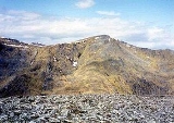
To the south of the main summit Sgurr na Lapaich has a subsidiary summit, Sgurr nan Clachan Geala (1,093 metres), listed as a "top" in Munro's Tables. Another minor summit, Rudha na Spreidhe, lies at the end of the mountain's northern spur and gives good views of Loch Monar; this was also formerly classed as a top, but has now been deleted from Munro's Tables.
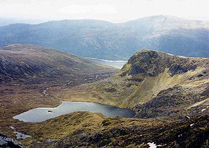
Deep, glacial corries surround the mountain on several sides. To the south-east of the summit the slopes fall steeply into a large corrie containing Loch Tuill Bhearnach, the largest of Sgurr na Lapaich's lochans at around 500 metres wide; further south is a smaller corrie surrounding Loch a' Choire Bhig. Both of these lochans drain into Loch Mullardoch. To the east of the summit is the steep, rocky head-wall of Coire nan Each, which is snow-filled until the late spring.
Ascent routes
Sgurr na Lapaich can be climbed either from Glen Strathfarrar or Glen Cannich. The usual approach from Glen Cannich starts at the parking spot at the Loch Mullardoch dam (grid reference ) and begins by ascending the Munro of Càrn nan Gobhar by its south ridge. The route then goes north-west to a colMountain pass
A mountain pass is a route through a mountain range or over a ridge. If following the lowest possible route, a pass is locally the highest point on that route...
at 796 metres before ascending the broad, grassy east ridge of Sgurr na Lapaich. This becomes rocky higher up, requiring some easy scrambling
Scrambling
Scrambling is a method of ascending rocky faces and ridges. It is an ambiguous term that lies somewhere between hillwalking and rock climbing. It is often distinguished from hillwalking by defining a scramble as a route where hands must be used in the ascent...
to reach the summit.
The approach from Glen Strathfarrar begins from the hydroelectric
Hydroelectricity
Hydroelectricity is the term referring to electricity generated by hydropower; the production of electrical power through the use of the gravitational force of falling or flowing water. It is the most widely used form of renewable energy...
power station in Gleann Innis (grid reference ), reached by a 17-mile drive from Struy along a private road; the locked gate at the entrance to this road is opened at specified times to give access to walkers.http://www.mountaineering-scotland.org.uk/access/strathfarrar.html From the power station a stalkers' path leads to the col between An Riabhachan and Sgurr na Lapaich, from where there is a further climb of over 300 metres to reach the summit.
The top of the mountain is marked by an Ordnance Survey
Ordnance Survey
Ordnance Survey , an executive agency and non-ministerial government department of the Government of the United Kingdom, is the national mapping agency for Great Britain, producing maps of Great Britain , and one of the world's largest producers of maps.The name reflects its creation together with...
trig point
Trig point
A triangulation station, also known as a triangulation pillar, trigonometrical station, trigonometrical point, trig station, trig beacon or trig point, and sometimes informally as a trig, is a fixed surveying station, used in geodetic surveying and other surveying projects in its vicinity...
.