
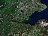
Firth
Encyclopedia

Scots language
Scots is the Germanic language variety spoken in Lowland Scotland and parts of Ulster . It is sometimes called Lowland Scots to distinguish it from Scottish Gaelic, the Celtic language variety spoken in most of the western Highlands and in the Hebrides.Since there are no universally accepted...
language and in English
English language
English is a West Germanic language that arose in the Anglo-Saxon kingdoms of England and spread into what was to become south-east Scotland under the influence of the Anglian medieval kingdom of Northumbria...
used to denote various coastal waters in Scotland
Scotland
Scotland is a country that is part of the United Kingdom. Occupying the northern third of the island of Great Britain, it shares a border with England to the south and is bounded by the North Sea to the east, the Atlantic Ocean to the north and west, and the North Channel and Irish Sea to the...
and England. In mainland Scotland it is used to describe a large sea bay, or even a strait
Strait
A strait or straits is a narrow, typically navigable channel of water that connects two larger, navigable bodies of water. It most commonly refers to a channel of water that lies between two land masses, but it may also refer to a navigable channel through a body of water that is otherwise not...
. In the Northern Isles
Northern Isles
The Northern Isles is a chain of islands off the north coast of mainland Scotland. The climate is cool and temperate and much influenced by the surrounding seas. There are two main island groups: Shetland and Orkney...
it more usually refers to a smaller inlet
Inlet
An inlet is a narrow body of water between islands or leading inland from a larger body of water, often leading to an enclosed body of water, such as a sound, bay, lagoon or marsh. In sea coasts an inlet usually refers to the actual connection between a bay and the ocean and is often called an...
. It is linguistically cognate
Cognate
In linguistics, cognates are words that have a common etymological origin. This learned term derives from the Latin cognatus . Cognates within the same language are called doublets. Strictly speaking, loanwords from another language are usually not meant by the term, e.g...
to fjord
Fjord
Geologically, a fjord is a long, narrow inlet with steep sides or cliffs, created in a valley carved by glacial activity.-Formation:A fjord is formed when a glacier cuts a U-shaped valley by abrasion of the surrounding bedrock. Glacial melting is accompanied by rebound of Earth's crust as the ice...
(both from Proto-Germanic *ferþuz) which has a more constrained sense in English; a firth would most likely be called a fjord if it were situated in Scandinavia
Scandinavia
Scandinavia is a cultural, historical and ethno-linguistic region in northern Europe that includes the three kingdoms of Denmark, Norway and Sweden, characterized by their common ethno-cultural heritage and language. Modern Norway and Sweden proper are situated on the Scandinavian Peninsula,...
. Bodies of water named "firths" tend to be more common on the east coast, or in the southwest of the country, although the Firth of Lorn is an exception to this. The Highland
Scottish Highlands
The Highlands is an historic region of Scotland. The area is sometimes referred to as the "Scottish Highlands". It was culturally distinguishable from the Lowlands from the later Middle Ages into the modern period, when Lowland Scots replaced Scottish Gaelic throughout most of the Lowlands...
coast contains numerous estuaries, straits and inlets of a similar kind, not called "firth", e.g. the Minch
The Minch
The Minch , also called The North Minch, is a strait in north-west Scotland, separating the north-west Highlands, and the northern Inner Hebrides, from Lewis and Harris in the Outer Hebrides...
, and Loch Torridon
Loch Torridon
Loch Torridon is a sea loch on the west coast of Scotland in the Northwest Highlands. The loch was created by glacial processes and is in total around 15 miles long. It has two sections: Upper Loch Torridon to landward, east of Rubha na h-Airde Ghlaise, at which point it joins Loch Sheildaig;...
; these are often called sea loch
Loch
Loch is the Irish and Scottish Gaelic word for a lake or a sea inlet. It has been anglicised as lough, although this is pronounced the same way as loch. Some lochs could also be called a firth, fjord, estuary, strait or bay...
s.
A firth is generally the result of ice age
Ice age
An ice age or, more precisely, glacial age, is a generic geological period of long-term reduction in the temperature of the Earth's surface and atmosphere, resulting in the presence or expansion of continental ice sheets, polar ice sheets and alpine glaciers...
glaciation
Glacier
A glacier is a large persistent body of ice that forms where the accumulation of snow exceeds its ablation over many years, often centuries. At least 0.1 km² in area and 50 m thick, but often much larger, a glacier slowly deforms and flows due to stresses induced by its weight...
and is very often associated with a large river, where erosion caused by the tidal effects of incoming sea water passing upriver has widened the riverbed into an estuary
Estuary
An estuary is a partly enclosed coastal body of water with one or more rivers or streams flowing into it, and with a free connection to the open sea....
. Demarcation can be rather vague. The Firth of Clyde
Firth of Clyde
The Firth of Clyde forms a large area of coastal water, sheltered from the Atlantic Ocean by the Kintyre peninsula which encloses the outer firth in Argyll and Ayrshire, Scotland. The Kilbrannan Sound is a large arm of the Firth of Clyde, separating the Kintyre Peninsula from the Isle of Arran.At...
is sometimes thought to include the estuary as far upriver as Dumbarton, but the Ordnance Survey
Ordnance Survey
Ordnance Survey , an executive agency and non-ministerial government department of the Government of the United Kingdom, is the national mapping agency for Great Britain, producing maps of Great Britain , and one of the world's largest producers of maps.The name reflects its creation together with...
map shows the change from river to firth occurring off Port Glasgow
Port Glasgow
Port Glasgow is the second largest town in the Inverclyde council area of Scotland. The population according to the 1991 census for Port Glasgow was 19426 persons and in the 2001 census was 16617 persons...
, while locally the change is held to be at the Tail of the Bank
Tail of the Bank
The Tail of the Bank is the name given to the anchorage in the upper Firth of Clyde immediately north of Greenock and Gourock. This area of the firth gets its name from the sandbar immediately to its east which marks the entrance to the estuary of the River Clyde.The Tail of the Bank was a...
where the river crosses a sandbar off Greenock
Greenock
Greenock is a town and administrative centre in the Inverclyde council area in United Kingdom, and a former burgh within the historic county of Renfrewshire, located in the west central Lowlands of Scotland...
at the junction to the Gare Loch
Gare Loch
The Gare Loch or Gareloch is a sea loch in Argyll and Bute, Scotland.-Geography:A sea loch aligned north-south, Gare Loch is 10 kilometres long with an average width of 1.5 kilometres. At its southern end it opens into the Firth of Clyde through the Rhu narrows...
, or even further west at Gourock
Gourock
Gourock is a town falling within the Inverclyde council area and formerly forming a burgh of the historic county of Renfrewshire in the west central Lowlands of Scotland. It has in the past functioned as a seaside resort on the Firth of Clyde...
point.
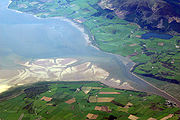
However, some firths are exceptions. The Cromarty Firth
Cromarty Firth
The Cromarty Firth of Cromarty') is an arm of the North Sea in Scotland. It is the middle of the three sea lochs at the head of the Moray Firth: to the north lies the Dornoch Firth, and to the south the Beauly Firth....
on the east coast of Scotland, for example, resembles a large loch
Loch
Loch is the Irish and Scottish Gaelic word for a lake or a sea inlet. It has been anglicised as lough, although this is pronounced the same way as loch. Some lochs could also be called a firth, fjord, estuary, strait or bay...
with only a relatively small outlet to the sea and the Solway Firth
Solway Firth
The Solway Firth is a firth that forms part of the border between England and Scotland, between Cumbria and Dumfries and Galloway. It stretches from St Bees Head, just south of Whitehaven in Cumbria, to the Mull of Galloway, on the western end of Dumfries and Galloway. The Isle of Man is also very...
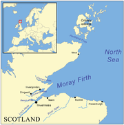
and the Moray Firth
Moray Firth
The Moray Firth is a roughly triangular inlet of the North Sea, north and east of Inverness, which is in the Highland council area of north of Scotland...
are more like extremely large bays. The Pentland Firth
Pentland Firth
The Pentland Firth , which is actually more of a strait than a firth, separates the Orkney Islands from Caithness in the north of Scotland.-Etymology:...
is a strait
Strait
A strait or straits is a narrow, typically navigable channel of water that connects two larger, navigable bodies of water. It most commonly refers to a channel of water that lies between two land masses, but it may also refer to a navigable channel through a body of water that is otherwise not...
rather than a bay or an inlet.
Firths on the west coast of Scotland (from north to south)

- Firth of Lorn (northernmost, connects with the Moray FirthMoray FirthThe Moray Firth is a roughly triangular inlet of the North Sea, north and east of Inverness, which is in the Highland council area of north of Scotland...
via the- Great GlenGreat GlenThe Great Glen , also known as Glen Albyn or Glen More is a series of glens in Scotland running 100 kilometres from Inverness on the Moray Firth, to Fort William at the head of Loch Linnhe.The Great Glen follows a large geological fault known as the Great Glen Fault...
lochs, the Caledonian CanalCaledonian CanalThe Caledonian Canal is a canal in Scotland that connects the Scottish east coast at Inverness with the west coast at Corpach near Fort William. It was constructed in the early nineteenth century by engineer Thomas Telford, and is a sister canal of the Göta Canal in Sweden, also constructed by...
and Loch NessLoch NessLoch Ness is a large, deep, freshwater loch in the Scottish Highlands extending for approximately southwest of Inverness. Its surface is above sea level. Loch Ness is best known for the alleged sightings of the cryptozoological Loch Ness Monster, also known affectionately as "Nessie"...
at InvernessInvernessInverness is a city in the Scottish Highlands. It is the administrative centre for the Highland council area, and is regarded as the capital of the Highlands of Scotland...
. - Lochs adjoining the Firth: Loch LochyLoch LochyLoch Lochy is a large freshwater loch in Lochaber, Highland, Scotland. With a mean depth of , it is the third deepest loch of Scotland.-Geography:...
, Loch LinnheLoch LinnheLoch Linnhe is a sea loch on the west coast of Scotland....
, Loch LevenLoch Leven (Highlands)Loch Leven 'is a sea loch on the west coast of Scotland. It is spelled Loch Lyon in Timothy Pont's map of the areaand is pronounced Li' un. There is a Leven in Lennox and another in Glen Lyon similarly pronounced...
, Loch OichLoch OichLoch Oich is a freshwater loch in the Highlands of Scotland which forms part of the Caledonian Canal, of which it is the highest point. This narrow loch lies between Loch Ness and Loch Lochy in the Great Glen...
. - Places: ObanObanOban Oban Oban ( is a resort town within the Argyll and Bute council area of Scotland. It has a total resident population of 8,120. Despite its small size, it is the largest town between Helensburgh and Fort William and during the tourist season the town can be crowded by up to 25,000 people. Oban...
, Fort William. - Islands: Isle of MullIsle of MullThe Isle of Mull or simply Mull is the second largest island of the Inner Hebrides, off the west coast of Scotland in the council area of Argyll and Bute....
, LismoreLismore, ScotlandLismore is a partially Gaelic speaking island in the Inner Hebrides of Scotland. This fertile, low-lying island was once a major centre of Celtic Christianity, with a monastery founded by Saint Moluag and the seat of the Bishop of Argyll.-Geography:...
and KerreraKerreraKerrera is an island in the Scottish Inner Hebrides, close to the town of Oban. In 2005 it had a population of about 35 people, and it is linked to the mainland by passenger ferry on the Gallanach Road....
.
- Great Glen
- Firth of ClydeFirth of ClydeThe Firth of Clyde forms a large area of coastal water, sheltered from the Atlantic Ocean by the Kintyre peninsula which encloses the outer firth in Argyll and Ayrshire, Scotland. The Kilbrannan Sound is a large arm of the Firth of Clyde, separating the Kintyre Peninsula from the Isle of Arran.At...
(continuing from the River ClydeRiver ClydeThe River Clyde is a major river in Scotland. It is the ninth longest river in the United Kingdom, and the third longest in Scotland. Flowing through the major city of Glasgow, it was an important river for shipbuilding and trade in the British Empire....
estuary)- Sea lochLochLoch is the Irish and Scottish Gaelic word for a lake or a sea inlet. It has been anglicised as lough, although this is pronounced the same way as loch. Some lochs could also be called a firth, fjord, estuary, strait or bay...
s adjoining the Firth of Clyde: Gare LochGare LochThe Gare Loch or Gareloch is a sea loch in Argyll and Bute, Scotland.-Geography:A sea loch aligned north-south, Gare Loch is 10 kilometres long with an average width of 1.5 kilometres. At its southern end it opens into the Firth of Clyde through the Rhu narrows...
, Loch LongLoch LongLoch Long is a body of water in Argyll and Bute, Scotland. The sea loch extends from the Firth of Clyde at its southwestern end. It measures approximately 20 miles in length, with a width of between one and two miles...
, Holy LochHoly LochThe Holy Loch is a sea loch in Argyll and Bute, Scotland.Robertson's Yard at Sandbank, a village on the loch, was a major wooden boat building company in the late 19th and early 20th centuries....
, Loch StrivenLoch StrivenLoch Striven is a sea loch adjoining the west side of the Firth of Clyde just north of the Isle of Bute, where it forms a narrow inlet about 8 miles long extending north into the Cowal peninsula. During times of recession in shipping the loch has been used as a sheltered anchorage for laid...
, Loch Riddon off the Kyles of ButeKyles of ButeThe Kyles of Bute are a narrow sea channel which separates the northern end of the Isle of Bute from the Cowal peninsula, part of the Scottish mainland....
, Loch FyneLoch FyneLoch Fyne is a sea loch on the west coast of Argyll and Bute, Scotland. It extends inland from the Sound of Bute, making it the longest of the sea lochs...
and Campbeltown LochCampbeltown LochCampbeltown Loch is a small sea loch near the south of the Kintyre Peninsula facing eastwards towards the Firth of Clyde. The town of Campbeltown, from which it takes its name, is located at its head. The island of Davaar is located in the loch, and can be reach by foot along a natural shingle...
. - Places: HelensburghHelensburghHelensburgh is a town in Argyll and Bute, Scotland. It lies on the north shore of the Firth of Clyde and the eastern shore of the entrance to the Gareloch....
, Port GlasgowPort GlasgowPort Glasgow is the second largest town in the Inverclyde council area of Scotland. The population according to the 1991 census for Port Glasgow was 19426 persons and in the 2001 census was 16617 persons...
, GreenockGreenockGreenock is a town and administrative centre in the Inverclyde council area in United Kingdom, and a former burgh within the historic county of Renfrewshire, located in the west central Lowlands of Scotland...
, GourockGourockGourock is a town falling within the Inverclyde council area and formerly forming a burgh of the historic county of Renfrewshire in the west central Lowlands of Scotland. It has in the past functioned as a seaside resort on the Firth of Clyde...
, DunoonDunoonDunoon is a resort town situated on the Cowal Peninsula in Argyll, Scotland. It sits on the Firth of Clyde to the south of Holy Loch and to the west of Gourock.-Waterfront:...
, RothesayRothesay, Argyll and ButeThe town of Rothesay is the principal town on the Isle of Bute, in the council area of Argyll and Bute, Scotland. It can be reached by ferry from Wemyss Bay which offers an onward rail link to Glasgow. At the centre of the town is Rothesay Castle, a ruined castle which dates back to the 13th...
, Wemyss BayWemyss BayWemyss Bay is a village on the coast of the Firth of Clyde falling within the Inverclyde council area and historic county of Renfrewshire in the west central Lowlands of Scotland. The name may derive from the Gaelic uaimh, meaning 'cave'...
, LargsLargsLargs is a town on the Firth of Clyde in North Ayrshire, Scotland, about from Glasgow. The original name means "the slopes" in Scottish Gaelic....
, Brodick, ArdrossanArdrossanArdrossan is a town on the North Ayrshire coast in south-western Scotland. The name "Ardrossan" describes its physical position — 'ard' from the Gaelic àird meaning headland, 'ros' a promontory and the diminutive suffix '-an' - headland of the little promontory...
, TroonTroonTroon is a town in South Ayrshire. It is situated on the west coast of Scotland, about eight miles north of Ayr and three miles northwest of Glasgow Prestwick International Airport. Lying across the Firth of Clyde, the Isle of Arran can be seen. Troon is also a port with freight and ferry services...
, AyrAyrAyr is a town and port situated on the Firth of Clyde in south-west Scotland. With a population of around 46,000, Ayr is the largest settlement in Ayrshire, of which it is the county town, and has held royal burgh status since 1205...
, GirvanGirvanGirvan is a burgh in Carrick, South Ayrshire, Scotland, with a population of about 8000 people. Originally a fishing port, it is now also a seaside resort with beaches and cliffs. Girvan dates back to 1668 when is became a municipal burgh incorporated by by charter...
and CampbeltownCampbeltownCampbeltown is a town and former royal burgh in Argyll and Bute, Scotland. It lies by Campbeltown Loch on the Kintyre peninsula. Originally known as Kinlochkilkerran , it was renamed in the 17th century as Campbell's Town after Archibald Campbell was granted the site in 1667...
. Note that GlasgowGlasgowGlasgow is the largest city in Scotland and third most populous in the United Kingdom. The city is situated on the River Clyde in the country's west central lowlands...
is at the tidal limit of the River ClydeRiver ClydeThe River Clyde is a major river in Scotland. It is the ninth longest river in the United Kingdom, and the third longest in Scotland. Flowing through the major city of Glasgow, it was an important river for shipbuilding and trade in the British Empire....
, and ClydebankClydebankClydebank is a town in West Dunbartonshire, in the Central Lowlands of Scotland. Situated on the north bank of the River Clyde, Clydebank borders Dumbarton, the town with which it was combined to form West Dunbartonshire, as well as the town of Milngavie in East Dunbartonshire, and the Yoker and...
, the Erskine BridgeErskine BridgeThe Erskine Bridge is a cable-stayed box girder bridge spanning the River Clyde in west central Scotland, connecting West Dunbartonshire with Renfrewshire....
and Dumbarton are on the river estuary as it widens out towards Port Glasgow. - IslandsIslands of the ClydeThe Islands of the Firth of Clyde are the fifth largest of the major Scottish island groups after the Inner and Outer Hebrides, Orkney and Shetland. They are situated in the Firth of Clyde between Ayrshire and Argyll. There are about forty islands and skerries, of which only six are inhabited and...
: ButeIsle of ButeBute is an island in the Firth of Clyde in Scotland. Formerly part of the county of Buteshire, it now constitutes part of the council area of Argyll and Bute. Its resident population was 7,228 in April 2001.-Geography:...
, CumbraeGreat CumbraeGreat Cumbrae is the larger of the two islands known as The Cumbraes in the lower Firth of Clyde in western Scotland...
, ArranIsle of ArranArran or the Isle of Arran is the largest island in the Firth of Clyde, Scotland, and with an area of is the seventh largest Scottish island. It is in the unitary council area of North Ayrshire and the 2001 census had a resident population of 5,058...
- In Scottish Gaelic, the Firth of Clyde is treated as two bodies, with the landward end being called Linne Chluaidh (ʎiɲəˈxɫ̪uəj) (meaning the same as the English), while the area around the south of Arran, Kintyre and Ayrshire/GallowayGallowayGalloway is an area in southwestern Scotland. It usually refers to the former counties of Wigtownshire and Kirkcudbrightshire...
is An Linne Ghlas ə ʎiɲə ɣɫ̪as̪.
- In Scottish Gaelic, the Firth of Clyde is treated as two bodies, with the landward end being called Linne Chluaidh (ʎiɲəˈxɫ̪uəj) (meaning the same as the English), while the area around the south of Arran, Kintyre and Ayrshire/Galloway
- Sea loch
- Solway FirthSolway FirthThe Solway Firth is a firth that forms part of the border between England and Scotland, between Cumbria and Dumfries and Galloway. It stretches from St Bees Head, just south of Whitehaven in Cumbria, to the Mull of Galloway, on the western end of Dumfries and Galloway. The Isle of Man is also very...
(inlet with the rivers EdenRiver Eden, CumbriaThe River Eden is a river that flows through Cumbria, England on its way to the Solway Firth.-Course of river:The Eden rises in Black Fell Moss, Mallerstang, on the high ground between High Seat, Yorkshire Dales and Hugh Seat. Here it forms the boundary between the counties of Cumbria and North...
, Esk and NithRiver NithThe River Nith is a river in South West Scotland.-Source, flow and mouth:The Nith rises in the Carsphairn hills of East Ayrshire, more precisely between Prickeny Hill and Enoch Hill, 7 km East of Dalmellington...
).- The Firth is off the Solway Coast.
- Rough FirthRough FirthRough Firth is an inlet on the northern coast of the Solway Firth in Dumfries and Galloway, Scotland.Rough Firth lies between Almorness Point and Castlehill Point. It contains Rough Island. The village of Kippford stands near the head of the firth where the Urr Water reaches the sea; the only other...
- Places: Carlisle, England on the River Eden, AnnanAnnan, Dumfries and GallowayThe royal burgh of Annan is a well-built town, red sandstone being the material mainly used. Each year in July, Annan celebrates the Royal Charter and the boundaries of the Royal Burgh are confirmed when a mounted cavalcade undertakes the Riding of the Marches. Entertainment includes a...
and Gretna, both in ScotlandScotlandScotland is a country that is part of the United Kingdom. Occupying the northern third of the island of Great Britain, it shares a border with England to the south and is bounded by the North Sea to the east, the Atlantic Ocean to the north and west, and the North Channel and Irish Sea to the...
. Luce BayLuce BayLuce Bay is a large bay in Wigtownshire in southern Scotland. The bay is 20 miles wide at its mouth and is bounded by the Rhins of Galloway to the west and the Machars to the east....
, WigtownWigtownWigtown is a town and former royal burgh in the Machars of Galloway in the south west of Scotland. It lies south of Newton Stewart and east of Stranraer. It has a population of about 1,000...
, St BeesSt BeesSt Bees is a village and civil parish in the Copeland district of Cumbria, in the North of England, about five miles west southwest of Whitehaven. The parish had a population of 1,717 according to the 2001 census. Within the parish is St...
, AspatriaAspatriaAspatria is a small town and civil parish in Cumbria, England, and lies half way between Maryport and Wigton, on the A596. Historically within Cumberland, it is about away from the coast. It is approximately seven miles from the northern boundary of the Lake District, and located to the south east...
Firths on the east coast of Scotland (from north to south)

North Sea
In the southwest, beyond the Straits of Dover, the North Sea becomes the English Channel connecting to the Atlantic Ocean. In the east, it connects to the Baltic Sea via the Skagerrak and Kattegat, narrow straits that separate Denmark from Norway and Sweden respectively...
.
- Dornoch FirthDornoch FirthThe Dornoch Firth is a firth on the east coast of Highland, in northern Scotland. It forms part of the boundary between Ross and Cromarty, to the south, and Sutherland, to the north....
(northernmost of the eastern firths)- Places: DornochDornochDornoch is a town and seaside resort, and former Royal burgh in the Highlands of Scotland. It lies on the north shore of the Dornoch Firth, near to where it opens into the Moray Firth to the east...
, Dornoch Bridge (impressive road bridge, half a mile long), Bonar BridgeBonar BridgeBonar Bridge is a village on the north bank of the Kyle of Sutherland, in the Parish of Creich in the Highland council area of Scotland.The Kyle of Sutherland is a river estuary of the Rivers Oykel, Cassley, Shin and Carron that all enter the Kyle above the bridge at Bonar.The estuary and the...
, Kyle of SutherlandKyle of SutherlandKyle of Sutherland is a river estuary that separates Sutherland from Ross-shire. It flows into the Dornoch Firth and is fed by the rivers Oykel, Shin, River Cassley and Carron.The downstream extent of the Kyle of Sutherland is the bridge at Bonar Bridge...
, TainTainTain is a royal burgh and post town in the committee area of Ross and Cromarty, in the Highland area of Scotland.-Etymology:...
, PortmahomackPortmahomackPortmahomack is a small fishing village in Easter Ross, Scotland. It is situated in the Tarbat Peninsula in the parish of Tarbat. Tarbat Ness Lighthouse is about three miles from the village at the end of the Tarbat Peninsula. Ballone Castle lies about a mile from the village...
on Tarbat Ness (fishing village facing west to northwest on the east coast). - Rivers: OykelRiver OykelThe River Oykel is a major river in northern Scotland that is famous for its salmon fishing. It rises on Ben More Assynt, a few miles from Ullapool on the west coast of Scotland, and drains into the North Sea via the Kyle of Sutherland...
, CassleyRiver CassleyThe River Cassley in Sutherland, in northern Scotland, drains into the Kyle of Sutherland at Invercassley , a short distance below where the River Oykel flows into the Kyle. The Kyle is subsequently joined by the River Shin about Inveran, before it becomes the Dornoch Firth at Bonar Bridge, into...
, ShinRiver ShinThe River Shin is a river in the Scottish North West Highlands.The river flows from Loch Shin into the Dornoch Firth and then into the North Sea. The river is just long....
and CarronRiver Carron, SutherlandThe River Carron is a river in Sutherland, in the Highlands of Scotland.It begins as the Abhainn a' Ghlinne Mhoir, which joins with the Alladale River to form the River Carron... - Headland: Tarbat Ness.
- Places: Dornoch
- Cromarty FirthCromarty FirthThe Cromarty Firth of Cromarty') is an arm of the North Sea in Scotland. It is the middle of the three sea lochs at the head of the Moray Firth: to the north lies the Dornoch Firth, and to the south the Beauly Firth....
(loch-type firth with relatively narrow opening to the sea). The Firth runs out into the Moray FirthMoray FirthThe Moray Firth is a roughly triangular inlet of the North Sea, north and east of Inverness, which is in the Highland council area of north of Scotland...
.- Places: CromartyCromartyThe Royal Burgh of Cromarty is a burgh in Ross and Cromarty, Highland, Scotland.-History:It was previously the county town of the former county of Cromartyshire...
, DingwallDingwallDingwall is a town and former royal burgh in the Highland council area of Scotland. It has a population of 5,026. It was formerly an east-coast harbor but now lies inland. Dingwall Castle was once the biggest castle north of Stirling. On the town's present-day outskirts lies Tulloch Castle, parts...
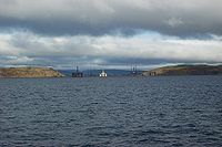
, InvergordonInvergordonInvergordon is a town and port in Easter Ross, in Ross and Cromarty, Highland, Scotland.-History:The town is well known for the Invergordon Mutiny of 1931. More recently it was also known for the repair of oil rigs which used to be lined up in the Cromarty Firth on which the town is situated...
. - Rivers: Conon, Orrin, Rusdale, Glass, Alness.
- Places: Cromarty
- Moray FirthMoray FirthThe Moray Firth is a roughly triangular inlet of the North Sea, north and east of Inverness, which is in the Highland council area of north of Scotland...
and Beauly FirthBeauly FirthThe Beauly Firth is a firth in northern Scotland. It is effectively a continuation of the Moray Firth westward, and is bounded at one end by Beauly and at the other by Inverness . The Kessock Ferry has crossed at the eastern end since the 15th Century...
(a loch-type firth) connected with the Firth of InvernessInvernessInverness is a city in the Scottish Highlands. It is the administrative centre for the Highland council area, and is regarded as the capital of the Highlands of Scotland...
. The Firth of Inverness is rarely identified on modern maps, but forms a connection via the River Ness, Loch NessLoch NessLoch Ness is a large, deep, freshwater loch in the Scottish Highlands extending for approximately southwest of Inverness. Its surface is above sea level. Loch Ness is best known for the alleged sightings of the cryptozoological Loch Ness Monster, also known affectionately as "Nessie"...
and the other lochLochLoch is the Irish and Scottish Gaelic word for a lake or a sea inlet. It has been anglicised as lough, although this is pronounced the same way as loch. Some lochs could also be called a firth, fjord, estuary, strait or bay...
s of the Great GlenGreat GlenThe Great Glen , also known as Glen Albyn or Glen More is a series of glens in Scotland running 100 kilometres from Inverness on the Moray Firth, to Fort William at the head of Loch Linnhe.The Great Glen follows a large geological fault known as the Great Glen Fault...
and stretches of the Caledonian CanalCaledonian CanalThe Caledonian Canal is a canal in Scotland that connects the Scottish east coast at Inverness with the west coast at Corpach near Fort William. It was constructed in the early nineteenth century by engineer Thomas Telford, and is a sister canal of the Göta Canal in Sweden, also constructed by...
with the Firth of LorneFirth of LorneThe Firth of Lorn is a body of water on Scotland's west coast, in Argyll and Bute. It lies between the Isle of Mull to the northwest and the Isles of Kerrera, Seil and Luing along with parts of the Scottish mainland southwest of Oban on the southeast side...
on the west coast of Scotland.- Places on the Moray Firth: Inverness, NairnNairnNairn is a town and former burgh in the Highland council area of Scotland. It is an ancient fishing port and market town around east of Inverness...
, FortroseFortroseFortrose is a burgh in the Scottish Highlands, located on the Moray Firth, approximately ten kilometres north east of Inverness. The town is known for its ruined 13th century cathedral, and as the home of the Brahan Seer. In the Middle Ages it was the seat of the bishopric of Ross...
, Fort GeorgeFort George, HighlandFort George , is a large 18th century fortress near Ardersier, to the north-east of Inverness in the Highland council area of Scotland. It was built to pacify the Scottish Highlands in the aftermath of the Jacobite rising of 1745, replacing an earlier Fort George built with the same aim after the...
. - Headlands: Whiteness Head, Chanonry Point, Alturlie Point.
- Places on the Beauly Firth: BeaulyBeaulyBeauly is a town of the Scottish county of Inverness-shire, on the River Beauly, 10 miles west of Inverness by the Far North railway line. Its population was 855 in 1901...
.
- Places on the Moray Firth: Inverness, Nairn
- Firth of TayFirth of TayThe Firth of Tay is a firth in Scotland between the council areas of Fife, Perth and Kinross, the City of Dundee and Angus, into which Scotland's largest river in terms of flow, the River Tay, empties....
(estuary of the River TayRiver TayThe River Tay is the longest river in Scotland and the seventh-longest in the United Kingdom. The Tay originates in western Scotland on the slopes of Ben Lui , then flows easterly across the Highlands, through Loch Dochhart, Loch Lubhair and Loch Tay, then continues east through Strathtay , in...
).- Places: PerthPerth, ScotlandPerth is a town and former city and royal burgh in central Scotland. Located on the banks of the River Tay, it is the administrative centre of Perth and Kinross council area and the historic county town of Perthshire...
, Dundee, MonifiethMonifiethMonifieth is a town and former police burgh in the council area of Angus, Scotland. It is situated on the North bank of the Firth of Tay on the East Coast...
, TayportTayportTayport is located in Fife, Scotland.Te oportet alte ferri - "It is encumbent on you to carry yourself high." This actually a rather terrible pun on:"Tayport at auld Tay Ferry"....
, Newport on Tay, Newburgh, FifeNewburgh, FifeNewburgh is a royal burgh of Fife, Scotland having a population of 2040 . Newburgh has grown little since 1901 when the population was counted at 1904 persons....
. - Rivers: TayRiver TayThe River Tay is the longest river in Scotland and the seventh-longest in the United Kingdom. The Tay originates in western Scotland on the slopes of Ben Lui , then flows easterly across the Highlands, through Loch Dochhart, Loch Lubhair and Loch Tay, then continues east through Strathtay , in...
, EarnRiver EarnThe River Earn in Scotland leaves Loch Earn at St Fillans and runs east through Strathearn, then east and south, joining the River Tay near Abernethy. The Earn is about long. It passes by Comrie, Crieff and Bridge of Earn....
. - Headland: Buddon Ness.
- Islands: Mugdrum IslandMugdrum IslandMugdrum Island lies in the Firth of Tay, offshore from the town of Newburgh, Fife, in the east of Scotland.-Geography:Mugdrum is low-lying and reedy, with the "North Deep" and "South Deep" channels on either side of the island. It covers an area of ....
- Places: Perth
- Firth of ForthFirth of ForthThe Firth of Forth is the estuary or firth of Scotland's River Forth, where it flows into the North Sea, between Fife to the north, and West Lothian, the City of Edinburgh and East Lothian to the south...
(estuary of the River ForthRiver ForthThe River Forth , long, is the major river draining the eastern part of the central belt of Scotland.The Forth rises in Loch Ard in the Trossachs, a mountainous area some west of Stirling...
)- Places: EdinburghEdinburghEdinburgh is the capital city of Scotland, the second largest city in Scotland, and the eighth most populous in the United Kingdom. The City of Edinburgh Council governs one of Scotland's 32 local government council areas. The council area includes urban Edinburgh and a rural area...
, DunfermlineDunfermlineDunfermline is a town and former Royal Burgh in Fife, Scotland, on high ground from the northern shore of the Firth of Forth. According to a 2008 estimate, Dunfermline has a population of 46,430, making it the second-biggest settlement in Fife. Part of the town's name comes from the Gaelic word...
, KirkcaldyKirkcaldyKirkcaldy is a town and former royal burgh in Fife, on the east coast of Scotland. The town lies on a shallow bay on the northern shore of the Firth of Forth; SSE of Glenrothes, ENE of Dunfermline, WSW of Dundee and NNE of Edinburgh...
, FalkirkFalkirkFalkirk is a town in the Central Lowlands of Scotland. It lies in the Forth Valley, almost midway between the two most populous cities of Scotland; north-west of Edinburgh and north-east of Glasgow....
, StirlingStirlingStirling is a city and former ancient burgh in Scotland, and is at the heart of the wider Stirling council area. The city is clustered around a large fortress and medieval old-town beside the River Forth...
, GrangemouthGrangemouthGrangemouth is a town and former burgh in the council area of Falkirk, Scotland. The town lies in the Forth Valley, on the banks of the Firth of Forth, east of Falkirk, west of Bo'ness and south-east of Stirling. Grangemouth had a resident population of 17,906 according to the 2001...
, RosythRosythRosyth is a town located on the Firth of Forth, three miles south of the centre of Dunfermline. According to an estimate taken in 2008, the town has a population of 12,790....
, North QueensferryNorth QueensferryNorth Queensferry is a village in Fife, Scotland, on the Firth of Forth, between the Forth Bridge and the Forth Road Bridge, and from Edinburgh. According to the 2008 population estimate, the village has a population of 1,150. It is the southernmost settlement in Fife.The Scottish Gaelic name...
, South QueensferrySouth QueensferrySouth Queensferry , also called Queensferry, is a former Royal Burgh in West Lothian now part of the City of Edinburgh, Scotland. It is located some ten miles to the north west of the city centre, on the shore of the Firth of Forth between the Forth Bridge and the Forth Road Bridge, approximately 8...
, MusselburghMusselburghMusselburgh is the largest settlement in East Lothian, Scotland, on the coast of the Firth of Forth, six miles east of Edinburgh city centre.-History:...
, CrailCrailCrail ; ) is a former royal burgh in the East Neuk of Fife, Scotland.-History:Crail probably dates from at least as far back as the Pictish period, as the place-name includes the Pictish/Brythonic element caer, 'fort', and there is a Dark Age cross-slab preserved in the parish kirk, itself...
, CellardykeCellardykeCellardyke is a village in the East Neuk of Fife, Scotland. The village is to the immediate east of Anstruther and is to the south of Kilrenny.- History :...
, AnstrutherAnstrutherAnstruther is a small town in Fife, Scotland. The two halves of Anstruther are divided by a small stream called Dreel Burn. Anstruther lies 9 miles south-southeast of St Andrews. It is the largest community on the stretch of north-shore coastline of the Firth of Forth known as the East Neuk,...
, PittenweemPittenweemPittenweem is a small and secluded fishing village and civil parish tucked in the corner of Fife on the east coast of Scotland. According to the 2006 estimate, the village has a population of 1,600. At the 2001 census, the parish had a population of 1,747....
, St Monans, Elie, Earlsferry, LongniddryLongniddryLongniddry is a village in East Lothian, Scotland, with a population of 2,613 .Longniddry is primarily a dormitory village for commuters to Edinburgh, with good transport links by road and rail to the capital...
, AberladyAberladyAberlady is a coastal village in the Scottish council area of East Lothian. On Aberlady Bay, it is five miles northwest of Haddington and approximately 18 miles east of Edinburgh, to which it is linked by the A198 Dunbar - Edinburgh road.Aberlady Parish Church dates back to the 15th century. It...
, GullaneGullaneGullane is a town on the southern shore of the Firth of Forth in East Lothian on the east coast of Scotland. There has been a church in the village since the 9th century. The ruins of the Old Church of St...
, DirletonDirletonDirleton is a village and parish in East Lothian, Scotland approximately east of Edinburgh on the A198. It contains . Dirleton lies between North Berwick , Gullane , Fenton Barns and the Yellowcraigs nature reserve, Archerfield Estate and the Firth of Forth...
, North BerwickNorth BerwickThe Royal Burgh of North Berwick is a seaside town in East Lothian, Scotland. It is situated on the south shore of the Firth of Forth, approximately 25 miles east of Edinburgh. North Berwick became a fashionable holiday resort in the 19th century because of its two sandy bays, the East Bay and the...
. It is spanned by the Forth Road BridgeForth Road BridgeThe Forth Road Bridge is a suspension bridge in east central Scotland. The bridge, opened in 1964, spans the Firth of Forth, connecting the capital city Edinburgh, at South Queensferry, to Fife, at North Queensferry...
, 2,512 m (8242 ft) long, and the Forth Bridge (the adjacent railway bridge)Forth Bridge (railway)The Forth Bridge is a cantilever railway bridge over the Firth of Forth in the east of Scotland, to the east of the Forth Road Bridge, and 14 kilometres west of central Edinburgh. It was opened on 4 March 1890, and spans a total length of...
, 2,498m (8,196 ft) long. - Rivers: ForthRiver ForthThe River Forth , long, is the major river draining the eastern part of the central belt of Scotland.The Forth rises in Loch Ard in the Trossachs, a mountainous area some west of Stirling...
, River AvonRiver Avon, FalkirkThe River Avon is a river in Falkirk, Scotland. It originates near Cumbernauld, flows through Avonbridge, through the Avon Gorge, through Muiravonside Country Park, Falkirk, past the west of Linlithgow and enters the Firth of Forth near Grangemouth....
, Water of LeithWater of LeithThe Water of Leith is the main river flowing through Edinburgh, Scotland, to the port of Leith where it flows into the sea via the Firth of Forth.It is long and rises in the Colzium Springs at Millstone Rig of the Pentland Hills...
, River AlmondRiver Almond, LothianThe River Almond is a river in east-central Scotland. It is 28 miles long, rising in North Lanarkshire near Shotts and runs through West Lothian, draining into the Firth of Forth at Cramond near Edinburgh....
, River EskRiver Esk, LothianThe River Esk is a river which flows through Midlothian and East Lothian, Scotland.It initially runs as two separate rivers, the North Esk and the South Esk....
, River LevenRiver Leven, FifeThe River Leven is a river in Fife in Scotland. It flows from Loch Leven into the Firth of Forth at the town of Leven. The river is home to brown trout and hosts a run of sea trout and atlantic salmon... - IslandsIslands of the ForthThe Islands of the Forth are a minor island group to the east of Scotland. The open waters of the Firth of Forth lie between Fife and the Lothians and contain most of the islands. The majority lie east of city of Edinburgh although two are to the west and two more lie in the estuary of the River...
: Bass RockBass RockThe Bass Rock, or simply The Bass, , is an island in the outer part of the Firth of Forth in the east of Scotland. It is approximately offshore, and north-east of North Berwick. It is a steep-sided volcanic rock, at its highest point, and is home to a large colony of gannets...
, CraigleithCraigleithCraigleith is a small island in the Firth of Forth off North Berwick in East Lothian, Scotland. Its name comes from the Scottish Gaelic Creag Lìte meaning "rock of Leith". It is 24 m at its highest point.-Geography and geology:...
, EyebroughyEyebroughyEyebroughy is an islet in the Firth of Forth, 200 m off East Lothian, Scotland. It is not far from Gullane and 3 miles from North Berwick, and forms part of the parish of Dirleton ....
, FidraFidraFidra is an uninhabited island in the Firth of Forth, north-west of North Berwick, on the east coast of Scotland.-Geography:...
, InchcolmInchcolmInchcolm is an island in the Firth of Forth in Scotland. Repeatedly attacked by English raiders during the Wars of Scottish Independence, it was fortified during both World Wars to defend nearby Edinburgh...
, InchgarvieInchgarvieInchgarvie is a small, uninhabited island in the Firth of Forth. Its name comes from Innis Garbhach which is Scottish Gaelic for "rough island"...
, InchkeithInchkeithInchkeith is an island in the Firth of Forth, Scotland. It is part of the council area of Fife.Inchkeith has had a colourful history as a result of its proximity to Edinburgh and strategic location for use as home for a lighthouse and for military purposes defending the Firth of Forth for attack...
, InchmickeryInchmickeryInchmickery is a small island in the Firth of Forth in Scotland. It is about a mile north of Edinburgh.Its name comes from the Scottish Gaelic, Innis nam Bhiocaire, meaning Isle of the Vicar, implying that there may have been an old ecclesiastical or Culdee settlement here, as in nearby Inchcolm...
, Isle of MayIsle of MayThe Isle of May is located in the north of the outer Firth of Forth, approximately off the coast of mainland Scotland. It is 1.8 km long and less than half a kilometre wide...
, The LambThe Lamb (island)The Lamb, sometimes called Lamb Island or just Lamb, is a small , uninhabited island between the islands of Fidra and Craigleith in the Firth of Forth, off the south-east coast of Scotland...
- Places: Edinburgh
Firths on the north coast of Scotland
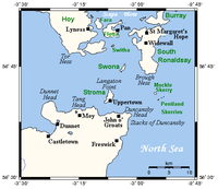
- The Pentland FirthPentland FirthThe Pentland Firth , which is actually more of a strait than a firth, separates the Orkney Islands from Caithness in the north of Scotland.-Etymology:...
. This is a strait between the Scottish mainland and the Orkney IslandsOrkney IslandsOrkney also known as the Orkney Islands , is an archipelago in northern Scotland, situated north of the coast of Caithness...
, and forms a link between the Atlantic OceanAtlantic OceanThe Atlantic Ocean is the second-largest of the world's oceanic divisions. With a total area of about , it covers approximately 20% of the Earth's surface and about 26% of its water surface area...
and North SeaNorth SeaIn the southwest, beyond the Straits of Dover, the North Sea becomes the English Channel connecting to the Atlantic Ocean. In the east, it connects to the Baltic Sea via the Skagerrak and Kattegat, narrow straits that separate Denmark from Norway and Sweden respectively...
.- Places: John o' GroatsJohn o' GroatsJohn o' Groats is a village in the Highland council area of Scotland. Part of the county of Caithness, John o' Groats is popular with tourists because it is usually regarded as the most northerly settlement of mainland Great Britain, although this is not a claim made by the inhabitants...
, CanisbayCanisbayCanisbay is a rural hamlet located about southwest of Huna and southwest of John o' Groats in Caithness, Scottish Highlands, and is in the Scottish council area of Highland...
, Gills BayGills BayGills Bay, which is situated some 3mls. West of John o' Groats with the community of Gills close by, has one of the longest stretches of low-lying rock coast on the northern shores of Caithness. Its main features are a small harbour and the pier used as the mainland terminal for Pentland Ferries...
, Rattar (all Caithness) - Headlands: Brims Ness, Brough Ness, Duncansby HeadDuncansby HeadDuncansby Head is the most north-easterly part of the Scottish mainland, including even the famous John o' Groats, Caithness, Highland...
, Dunnet HeadDunnet HeadDunnet Head is a peninsula in Caithness, on the north coast of Scotland, that includes the most northerly point of the mainland of Great Britain. The point, known as Easter Head, is at , about westnorthwest of John o' Groats and about from Duncansby Head... - Islands: HoyHoyHoy is an island in Orkney, Scotland. With an area of it is the second largest in the archipelago after the Mainland. It is connected by a causeway called The Ayre to South Walls...
, Pentland SkerriesPentland SkerriesThe Pentland Skerries are a group of four uninhabited islands lying in the Pentland Firth, northeast of Duncansby Head and south of South Ronaldsay in Scotland....
, SwonaSwonaSwona is an uninhabited island in the Pentland Firth off the north coast of Scotland.-Geography and geology:Swona is the more northerly of two islands in the Pentland Firth between the Orkney Islands and Caithness on the Scottish mainland...
, South RonaldsaySouth RonaldsaySouth Ronaldsay is one of the Orkney Islands off the north coast of Scotland. It is linked to the Orkney Mainland by the Churchill Barriers, running via Burray, Glimps Holm and Lamb Holm.-Geography and geology:...
, South WallsSouth WallsSouth Walls is an inhabited island adjacent to Hoy in Orkney, Scotland. The name is a corruption of "Sooth Was", which means the "southern voes" - as with Kirkwall, it was assumed that it was a mispronunciation of "walls"....
(all generally considered to be part of Orkney); StromaStroma, ScotlandStroma is an island off the northern coast of the Scottish mainland. It is the more southerly of the two islands in the Pentland Firth between the Orkney Islands and Caithness. It is administratively part of Caithness , while its neighbour Swona, to the north, is part of the Orkney Islands...
- Places: John o' Groats
Firths in the Northern Isles

- Orkney IslandsOrkney IslandsOrkney also known as the Orkney Islands , is an archipelago in northern Scotland, situated north of the coast of Caithness...
- Bay of Firth (Firth, OrkneyFirth, OrkneyFirth is a parish mainly in Mainland, Orkney. The islands of Damsay and Holm of Grimbister, which lie in the Bay of Firth, are also in the parish...
) - North RonaldsayNorth RonaldsayNorth Ronaldsay is the northernmost of the Orkney Islands, Scotland and with an area of is the fourteenth largest.-Geography:North Ronaldsay lies around north of its nearest neighbour, Sanday at . The island is around long along its length and is defined by two large sandy bays; Linklet Bay on...
Firth - StronsayStronsayStronsay is an island in Orkney, off the north coast of Scotland. The main village is Whitehall, home to a heritage centre. It is in size, and at its highest point....
Firth - WestrayWestrayWestray is one of the Orkney Islands in Scotland, with a population of around 550 people. Its main village is Pierowall, with a heritage centre, the ruined Lady Kirk and ferries to Papa Westray.-Geography and geology:...
Firth - Wide Firth
- Bay of Firth (Firth, Orkney
- Shetland IslandsShetland IslandsShetland is a subarctic archipelago of Scotland that lies north and east of mainland Great Britain. The islands lie some to the northeast of Orkney and southeast of the Faroe Islands and form part of the division between the Atlantic Ocean to the west and the North Sea to the east. The total...
(Mainland)- Lax Firth (Laxfirth) & Cat Firth near NestingNesting, ShetlandNesting is a parish in the east of Mainland, Shetland. It includes not only a part of the Mainland, measure about twelve miles by four, on coast and seaboard from Gletness to Lunna Ness; comprehends also the islands of Whalsay and the Out Skerries, and is much diversified on all its coasts by voes...
& WhitenessWhiteness, ShetlandWhiteness is a village and parish in the Shetland Islands, on Mainland.The village lies seven miles north north west of Lerwick. The parish is now merged with Tingwall. The village has a Methodist church located in South Whiteness and the Whiteness Primary School faces Whitedale F.C.'s Football... - Collafirth/Colla Firth (two places of this name)
- Firths Voe, FirthFirth, ShetlandNote: "Firth" is a common name for sounds in ShetlandFirth is a village in the north east of Mainland, Shetland, in the parish of Delting, not far from Mossbank. It is about 27 miles from Lerwick.-History:...
- Gon Firth
- Olna Firth
- Olnes Firth
- Quey Firth
- Unie Firth
- Ura Firth
- Burra Firth/Burrafirth (a number of Shetland places with this name)
- Effirth
- Lax Firth (Laxfirth) & Cat Firth near Nesting
- Shetland North IslesNorth IslesThe North Isles are the northern islands of the Shetland Islands, Scotland. The main islands in the group are Yell, Unst and Fetlar. Sometimes the islands in Yell Sound are included in this group.- Importance :...
: Yell, UnstUnstUnst is one of the North Isles of the Shetland Islands, Scotland. It is the northernmost of the inhabited British Isles and is the third largest island in Shetland after the Mainland and Yell. It has an area of .Unst is largely grassland, with coastal cliffs...
- Whale Firth
- Burrafirth
Other similar waters in Scotland
Scottish Gaelic language
Scottish Gaelic is a Celtic language native to Scotland. A member of the Goidelic branch of the Celtic languages, Scottish Gaelic, like Modern Irish and Manx, developed out of Middle Irish, and thus descends ultimately from Primitive Irish....
, linne is used to refer to most of the firths above; it is also applied to the Sound of Sleat
Sound of Sleat
The Sound of Sleat is a narrow sea channel off the western coast of Scotland. It divides the Sleat peninsula on the south-east side of the Isle of Skye from Morar, Knoydart and Glenelg on the Scottish mainland....
, Crowlin Sound, Cuillin Sound, Sound of Jura
Sound of Jura
The Sound of Jura is a strait in Argyll and Bute, Scotland. The Gaelic name means "Sound of Disappointment". It is one of the several Sounds of Scotland....
, Sound of Raasay, and part of Loch Linnhe
Loch Linnhe
Loch Linnhe is a sea loch on the west coast of Scotland....
.
The following is a selection of other bodies of water in Scotland which are similar to various firths, but which are not termed such -
- West coast
- Loch BroomLoch BroomLoch Broom is a sea loch located in northwestern Ross and Cromarty, in the former parish of Lochbroom, in the west coast of Scotland. The small town of Ullapool lies on the eastern shore of the loch...
(fjord), Loch EribollLoch EribollLoch Eriboll is a long sea loch on the north coast of Scotland, which has been used for centuries as a deep water anchorage as it is safe from the often stormy seas of Cape Wrath and the Pentland Firth...
(fjord), Loch FyneLoch FyneLoch Fyne is a sea loch on the west coast of Argyll and Bute, Scotland. It extends inland from the Sound of Bute, making it the longest of the sea lochs...
(fjord), Loch HournLoch HournLoch Hourn is a sea loch to the north of Knoydart, on the west coast of Scotland.-Geography:Loch Hourn runs inland from the Sound of Sleat, opposite the island of Skye, for 22 km to the head of the loch at Kinloch Hourn...
(fjord), Loch Tarbert, JuraLoch Tarbert, JuraLoch Tarbert is a sea loch on the west coast of Jura, an island in Scotland.As the name Tarbert suggests, it comes close to cutting the island in half....
(fjord), Loch TorridonLoch TorridonLoch Torridon is a sea loch on the west coast of Scotland in the Northwest Highlands. The loch was created by glacial processes and is in total around 15 miles long. It has two sections: Upper Loch Torridon to landward, east of Rubha na h-Airde Ghlaise, at which point it joins Loch Sheildaig;...
(fjord); Loch Sween, a fjord, The MinchThe MinchThe Minch , also called The North Minch, is a strait in north-west Scotland, separating the north-west Highlands, and the northern Inner Hebrides, from Lewis and Harris in the Outer Hebrides...
(Strait, "Skotlandsfjörð" ("Scotland's fjordFjordGeologically, a fjord is a long, narrow inlet with steep sides or cliffs, created in a valley carved by glacial activity.-Formation:A fjord is formed when a glacier cuts a U-shaped valley by abrasion of the surrounding bedrock. Glacial melting is accompanied by rebound of Earth's crust as the ice...
/firth") in Old NorseOld NorseOld Norse is a North Germanic language that was spoken by inhabitants of Scandinavia and inhabitants of their overseas settlements during the Viking Age, until about 1300....
.)
- Loch Broom
- East coast
- Eden Mouth (estuary, near St AndrewsSt AndrewsSt Andrews is a university town and former royal burgh on the east coast of Fife in Scotland. The town is named after Saint Andrew the Apostle.St Andrews has a population of 16,680, making this the fifth largest settlement in Fife....
); Findhorn BayRiver FindhornThe River Findhorn is one of the longest rivers in Scotland. Located in the north east, it flows into the Moray Firth on the north coast. It has one of the largest non-firth estuaries in Scotland....
, Montrose BasinMontrose BasinThe Montrose Basin is part of the estuary of the South Esk forming a tidal basin near to the town of Montrose, Angus, on the north-east coast of Scotland....
(estuary/lagoon with narrow entrance); Tweed mouth (estuary, very near Scottish border)
- Eden Mouth (estuary, near St Andrews
Likewise, in the Northern Isles
Northern Isles
The Northern Isles is a chain of islands off the north coast of mainland Scotland. The climate is cool and temperate and much influenced by the surrounding seas. There are two main island groups: Shetland and Orkney...
, the words "firth" and "sound" are often used arbitrarily or interchangeably. Bluemull Sound
Bluemull Sound
Bluemull Sound is the strait between Unst and Yell in Shetland's North Isles. A ferry service crosses it regularly. Cullivoe is on the Yell side, and the island of Linga lies in the strait....
for example, is very similar to some of the firths in the Shetland Islands
Shetland Islands
Shetland is a subarctic archipelago of Scotland that lies north and east of mainland Great Britain. The islands lie some to the northeast of Orkney and southeast of the Faroe Islands and form part of the division between the Atlantic Ocean to the west and the North Sea to the east. The total...
.
English Firths
- Solway FirthSolway FirthThe Solway Firth is a firth that forms part of the border between England and Scotland, between Cumbria and Dumfries and Galloway. It stretches from St Bees Head, just south of Whitehaven in Cumbria, to the Mull of Galloway, on the western end of Dumfries and Galloway. The Isle of Man is also very...
(inlet with the rivers EdenRiver Eden, CumbriaThe River Eden is a river that flows through Cumbria, England on its way to the Solway Firth.-Course of river:The Eden rises in Black Fell Moss, Mallerstang, on the high ground between High Seat, Yorkshire Dales and Hugh Seat. Here it forms the boundary between the counties of Cumbria and North...
, Esk and NithRiver NithThe River Nith is a river in South West Scotland.-Source, flow and mouth:The Nith rises in the Carsphairn hills of East Ayrshire, more precisely between Prickeny Hill and Enoch Hill, 7 km East of Dalmellington...
).- The Firth is off the Solway Coast.
- Rough FirthRough FirthRough Firth is an inlet on the northern coast of the Solway Firth in Dumfries and Galloway, Scotland.Rough Firth lies between Almorness Point and Castlehill Point. It contains Rough Island. The village of Kippford stands near the head of the firth where the Urr Water reaches the sea; the only other...
- Places: Carlisle, England on the River Eden, AnnanAnnan, Dumfries and GallowayThe royal burgh of Annan is a well-built town, red sandstone being the material mainly used. Each year in July, Annan celebrates the Royal Charter and the boundaries of the Royal Burgh are confirmed when a mounted cavalcade undertakes the Riding of the Marches. Entertainment includes a...
and Gretna, both in ScotlandScotlandScotland is a country that is part of the United Kingdom. Occupying the northern third of the island of Great Britain, it shares a border with England to the south and is bounded by the North Sea to the east, the Atlantic Ocean to the north and west, and the North Channel and Irish Sea to the...
. Luce BayLuce BayLuce Bay is a large bay in Wigtownshire in southern Scotland. The bay is 20 miles wide at its mouth and is bounded by the Rhins of Galloway to the west and the Machars to the east....
, WigtownWigtownWigtown is a town and former royal burgh in the Machars of Galloway in the south west of Scotland. It lies south of Newton Stewart and east of Stranraer. It has a population of about 1,000...
, St BeesSt BeesSt Bees is a village and civil parish in the Copeland district of Cumbria, in the North of England, about five miles west southwest of Whitehaven. The parish had a population of 1,717 according to the 2001 census. Within the parish is St...
, AspatriaAspatriaAspatria is a small town and civil parish in Cumbria, England, and lies half way between Maryport and Wigton, on the A596. Historically within Cumberland, it is about away from the coast. It is approximately seven miles from the northern boundary of the Lake District, and located to the south east...
Firths outside Scottish waters
- Firth of Flensburg, an estuary forming part of the border between DenmarkDenmarkDenmark is a Scandinavian country in Northern Europe. The countries of Denmark and Greenland, as well as the Faroe Islands, constitute the Kingdom of Denmark . It is the southernmost of the Nordic countries, southwest of Sweden and south of Norway, and bordered to the south by Germany. Denmark...
and Germany - The Firth of ThamesFirth of ThamesThe Firth of Thames is a large bay located in the north of the North Island of New Zealand. It is the firth of the rivers Waihou and Piako, the former of which was formerly named the Thames River, and the town of Thames lies on its southeastern coast....
is a bay at the mouth of the Waihou RiverWaihou Riverthumb|The Waihou River near [[Putaruru]]The Waihou River is located in the northern North Island of New Zealand. Its former name, Thames River, was bestowed by Captain James Cook....
(formerly named the Thames) in New ZealandNew ZealandNew Zealand is an island country in the south-western Pacific Ocean comprising two main landmasses and numerous smaller islands. The country is situated some east of Australia across the Tasman Sea, and roughly south of the Pacific island nations of New Caledonia, Fiji, and Tonga... - Firth of TayFirth of Tay (Antarctica)Firth of Tay is a sound, 12 miles long and 6 miles wide, extending in a NW-SE direction between the northeast side of Dundee Island and the east portion of Joinville Island. It merges to the northwest with Active Sound with which it completes the separation of Dundee and Joinville Islands...
, Antarctica. Named in conjunction with neighbouring Dundee IslandDundee IslandDundee Island is an ice-covered island lying east of the northeastern tip of Antarctic Peninsula and south of Joinville Island.On January 8, 1893, during the Dundee Whaling Expedition, the island was named by Captain Thomas Robertson of the Active and named for the home port, Dundee, Scotland,...
, as the original Firth of Tay adjoins Dundee.