
Waddington Range
Encyclopedia
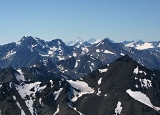
The Waddington Range is a subrange of the Pacific Ranges
of the Coast Mountains
in southwestern British Columbia
, Canada
. It is only about 4000 km² (1545 sq mi) in area, relatively small in area within the expanse of the range, but it is the highest area of the Pacific Ranges
and of the Coast Mountains
, being crowned by its namesake Mount Waddington
4019 m (13186 ft). The Waddington Range is also extremely rugged and more a complex of peaks than a single icefield, in contrast to the other huge icefield-massifs of the southern Coast Mountains
, which are not so peak-studded and tend to have more contiguous icemasses.
until 1936; it had only been espied from Vancouver Island
by climbers in the 1930s and was at first referred to as Mystery Mountain - because its existence until then had been unknown. Apparently even in First Nations
lore its existence was spoken of only vaguely, as a possibility, and it seems unlikely the core of the massif was penetrated by any First Nations
adventurer given the tremendous difficulty posed even for mountaineers equipped with modern outdoor gear.
At its eastern edge, deep in the Grand Canyon of the Homathko River
, occurred the first gruesome event in the guerilla war known to history as the Chilcotin War
of 1864. This resulted from the attempt by Alfred Waddington
to build a road from Bute Inlet
to Barkerville
. Port Waddington, a land-survey left over from those days, remains on the map on the south bank of the Homathko
where it empties into Bute Inlet
.
Waddington's Road was never completed because of the war, but was examined in later years as one of the main possible routings for the mainline of the Canadian Pacific Railway
. Choice of the route would see the terminus of the railway at Victoria
but despite strong favour from that city and the province the railway chose Burrard Inlet
, which as a result became today's Vancouver.
, while to its south is the Whitemantle Range
. Northeast across Mosley Creek, the main west fork of the Homathko River
, is the Niut Range
, while east across the Homathko River
is the Homathko Icefield
and its attendant ranges. Northwest across the Klinaklini River
is the Ha-Iltzuk Icefield
, which is the largest of the coastal icecaps of the southern Coast Mountains, larger than the Waddington Range's complex of glaciers and peaks or the Homathko Icefield
.
Pacific Ranges
The Pacific Ranges are the southernmost subdivision of the Coast Mountains portion of the Pacific Cordillera. Located entirely within British Columbia, Canada, they run northwest from the lower stretches of the Fraser River to Bella Coola, north of which are the Kitimat Ranges.The Pacific Ranges...
of the Coast Mountains
Coast Mountains
The Coast Mountains are a major mountain range, in the Pacific Coast Ranges, of western North America, extending from southwestern Yukon through the Alaska Panhandle and virtually all of the Coast of British Columbia. They are so-named because of their proximity to the sea coast, and are often...
in southwestern British Columbia
British Columbia
British Columbia is the westernmost of Canada's provinces and is known for its natural beauty, as reflected in its Latin motto, Splendor sine occasu . Its name was chosen by Queen Victoria in 1858...
, Canada
Canada
Canada is a North American country consisting of ten provinces and three territories. Located in the northern part of the continent, it extends from the Atlantic Ocean in the east to the Pacific Ocean in the west, and northward into the Arctic Ocean...
. It is only about 4000 km² (1545 sq mi) in area, relatively small in area within the expanse of the range, but it is the highest area of the Pacific Ranges
Pacific Ranges
The Pacific Ranges are the southernmost subdivision of the Coast Mountains portion of the Pacific Cordillera. Located entirely within British Columbia, Canada, they run northwest from the lower stretches of the Fraser River to Bella Coola, north of which are the Kitimat Ranges.The Pacific Ranges...
and of the Coast Mountains
Coast Mountains
The Coast Mountains are a major mountain range, in the Pacific Coast Ranges, of western North America, extending from southwestern Yukon through the Alaska Panhandle and virtually all of the Coast of British Columbia. They are so-named because of their proximity to the sea coast, and are often...
, being crowned by its namesake Mount Waddington
Mount Waddington
Mount Waddington, once known as Mystery Mountain, is the highest peak in the Coast Mountains of British Columbia, Canada. Although Mount Fairweather and Mount Quincy Adams, which straddle the US border between Alaska and British Columbia are taller, Mount Waddington is the highest peak that lies...
4019 m (13186 ft). The Waddington Range is also extremely rugged and more a complex of peaks than a single icefield, in contrast to the other huge icefield-massifs of the southern Coast Mountains
Coast Mountains
The Coast Mountains are a major mountain range, in the Pacific Coast Ranges, of western North America, extending from southwestern Yukon through the Alaska Panhandle and virtually all of the Coast of British Columbia. They are so-named because of their proximity to the sea coast, and are often...
, which are not so peak-studded and tend to have more contiguous icemasses.
History
The difficulty of access to the core of the massif delayed actual sighting, measurement and climbing of Mount WaddingtonMount Waddington
Mount Waddington, once known as Mystery Mountain, is the highest peak in the Coast Mountains of British Columbia, Canada. Although Mount Fairweather and Mount Quincy Adams, which straddle the US border between Alaska and British Columbia are taller, Mount Waddington is the highest peak that lies...
until 1936; it had only been espied from Vancouver Island
Vancouver Island
Vancouver Island is a large island in British Columbia, Canada. It is one of several North American locations named after George Vancouver, the British Royal Navy officer who explored the Pacific Northwest coast of North America between 1791 and 1794...
by climbers in the 1930s and was at first referred to as Mystery Mountain - because its existence until then had been unknown. Apparently even in First Nations
First Nations
First Nations is a term that collectively refers to various Aboriginal peoples in Canada who are neither Inuit nor Métis. There are currently over 630 recognised First Nations governments or bands spread across Canada, roughly half of which are in the provinces of Ontario and British Columbia. The...
lore its existence was spoken of only vaguely, as a possibility, and it seems unlikely the core of the massif was penetrated by any First Nations
First Nations
First Nations is a term that collectively refers to various Aboriginal peoples in Canada who are neither Inuit nor Métis. There are currently over 630 recognised First Nations governments or bands spread across Canada, roughly half of which are in the provinces of Ontario and British Columbia. The...
adventurer given the tremendous difficulty posed even for mountaineers equipped with modern outdoor gear.
At its eastern edge, deep in the Grand Canyon of the Homathko River
Homathko River
The Homathko River is one of the major rivers of the southern Coast Mountains of British Columbia, and one of the few rivers that penetrates the range from the Chilcotin Plateau to the coastal inlets, entering the sea at the head of Bute Inlet adjacent to the mouth of the Southgate River, just to...
, occurred the first gruesome event in the guerilla war known to history as the Chilcotin War
Chilcotin War
The Chilcotin War, Chilcotin Uprising or Bute Inlet Massacre was a confrontation in 1864 between members of the Tsilhqot'in people in British Columbia and white road construction workers...
of 1864. This resulted from the attempt by Alfred Waddington
Alfred Waddington
Alfred Penderell Waddington was born in 1801 in the Brompton, Kensington, district of London, England. During his later years, Waddington was actively involved in the Colony of Vancouver Island in what later became the province of British Columbia, Canada....
to build a road from Bute Inlet
Bute Inlet
Bute Inlet is one of the principal inlets of the British Columbia Coast. It is 80 km long from its head at the mouths of the Homathko and Southgate Rivers to the continental headlands at its mouth, where it is nearly blocked by Stuart Island, and it averages about 4 km in width...
to Barkerville
Barkerville, British Columbia
Barkerville was the main town of the Cariboo Gold Rush in British Columbia, Canada and is preserved as a historic town. It is located on the north slope of the Cariboo Plateau near the Cariboo Mountains east of Quesnel along BC Highway 26, which follows the route of the original access to...
. Port Waddington, a land-survey left over from those days, remains on the map on the south bank of the Homathko
Homathko River
The Homathko River is one of the major rivers of the southern Coast Mountains of British Columbia, and one of the few rivers that penetrates the range from the Chilcotin Plateau to the coastal inlets, entering the sea at the head of Bute Inlet adjacent to the mouth of the Southgate River, just to...
where it empties into Bute Inlet
Bute Inlet
Bute Inlet is one of the principal inlets of the British Columbia Coast. It is 80 km long from its head at the mouths of the Homathko and Southgate Rivers to the continental headlands at its mouth, where it is nearly blocked by Stuart Island, and it averages about 4 km in width...
.
Waddington's Road was never completed because of the war, but was examined in later years as one of the main possible routings for the mainline of the Canadian Pacific Railway
Canadian Pacific Railway
The Canadian Pacific Railway , formerly also known as CP Rail between 1968 and 1996, is a historic Canadian Class I railway founded in 1881 and now operated by Canadian Pacific Railway Limited, which began operations as legal owner in a corporate restructuring in 2001...
. Choice of the route would see the terminus of the railway at Victoria
Victoria, British Columbia
Victoria is the capital city of British Columbia, Canada and is located on the southern tip of Vancouver Island off Canada's Pacific coast. The city has a population of about 78,000 within the metropolitan area of Greater Victoria, which has a population of 360,063, the 15th most populous Canadian...
but despite strong favour from that city and the province the railway chose Burrard Inlet
Burrard Inlet
Burrard Inlet is a relatively shallow-sided coastal fjord in southwestern British Columbia, Canada. Formed during the last Ice Age, it separates the City of Vancouver and the rest of the low-lying Burrard Peninsula from the slopes of the North Shore Mountains, home to the communities of West...
, which as a result became today's Vancouver.
Neighbouring Ranges and Icefields
Immediately north of the Waddington Range is the Pantheon RangePantheon Range
The Pantheon Range is a subrange of the Pacific Ranges of the Coast Mountains in British Columbia. It is located between the edge of the Chilcotin Plateau at Tatla Lake on its northeast and the Klinaklini River on its west, with a southeastern boundary along Mosley Creek, a major tributary of the...
, while to its south is the Whitemantle Range
Whitemantle Range
The Whitemantle Range is a subrange of the Pacific Ranges of the Coast Mountains in British Columbia. Located between the heads of Bute Inlet on the east and Knight Inlet on the west, it is extremely rugged and glaciated...
. Northeast across Mosley Creek, the main west fork of the Homathko River
Homathko River
The Homathko River is one of the major rivers of the southern Coast Mountains of British Columbia, and one of the few rivers that penetrates the range from the Chilcotin Plateau to the coastal inlets, entering the sea at the head of Bute Inlet adjacent to the mouth of the Southgate River, just to...
, is the Niut Range
Niut Range
The Niut Range is 3600 km² in area. It is a subrange of the Pacific Ranges of the Coast Mountains of British Columbia, although in some classifications it is considered part of the Chilcotin Ranges . The Niut and is located in the angle of the Homathko River and its main west fork, Mosley...
, while east across the Homathko River
Homathko River
The Homathko River is one of the major rivers of the southern Coast Mountains of British Columbia, and one of the few rivers that penetrates the range from the Chilcotin Plateau to the coastal inlets, entering the sea at the head of Bute Inlet adjacent to the mouth of the Southgate River, just to...
is the Homathko Icefield
Homathko Icefield
The Homathko Icefield is an icefield in British Columbia, Canada. Officially named the Homathko Snowfield from 1950 until the current name was adopted in 1976, it is one of the largest icefields in the southern half of the Coast Mountains, with an area of over...
and its attendant ranges. Northwest across the Klinaklini River
Klinaklini River
The Klinaklini River is one of the major rivers of the Pacific Ranges section of the Coast Mountains in British Columbia. It begins in the northern basins of the Pantheon Range to the north of Mount Waddington and briefly heads northeast onto the Chilcotin Plateau before bending around...
is the Ha-Iltzuk Icefield
Ha-Iltzuk Icefield
The Ha-Iltzuk Icefield is an icefield in the central Pacific Ranges of the Coast Mountains in British Columbia, Canada. It is the largest icefield in the Coast Mountains south of the Alaska Panhandle, with an area of . It is located on the west side of the Klinaklini River and the Waddington Range...
, which is the largest of the coastal icecaps of the southern Coast Mountains, larger than the Waddington Range's complex of glaciers and peaks or the Homathko Icefield
Homathko Icefield
The Homathko Icefield is an icefield in British Columbia, Canada. Officially named the Homathko Snowfield from 1950 until the current name was adopted in 1976, it is one of the largest icefields in the southern half of the Coast Mountains, with an area of over...
.