

Bridge River Power Project
Encyclopedia
Canada
Canada is a North American country consisting of ten provinces and three territories. Located in the northern part of the continent, it extends from the Atlantic Ocean in the east to the Pacific Ocean in the west, and northward into the Arctic Ocean...
province
Provinces and territories of Canada
The provinces and territories of Canada combine to make up the world's second-largest country by area. There are ten provinces and three territories...
of British Columbia
British Columbia
British Columbia is the westernmost of Canada's provinces and is known for its natural beauty, as reflected in its Latin motto, Splendor sine occasu . Its name was chosen by Queen Victoria in 1858...
, located in the Lillooet Country
Lillooet Country
The Lillooet Country, also referred to as the Lillooet District., is a region spanning from the central Fraser Canyon town of Lillooet west to the valley of the Lillooet River, and including the valleys in between, in the Southern Interior of British Columbia. Like other historical BC regions, it...
between Whistler
Whistler, British Columbia
Whistler is a Canadian resort town in the southern Pacific Ranges of the Coast Mountains in the province of British Columbia, Canada, approximately north of Vancouver...
and Lillooet
Lillooet, British Columbia
Lillooet is a community on the Fraser River in western Canada, about up the British Columbia Railway line from Vancouver. Situated at an intersection of deep gorges in the lee of the Coast Mountains, it has a dry climate- of precipitation is recorded annually at the town's weather station,...
. It harnesses the power of the Bridge River
Bridge River
The Bridge River is, or was, a major tributary of British Columbia's Fraser River, entering that stream about six miles upstream from the town of Lillooet.-Name:Its name in the Lillooet language is Xwisten , sometimes spelled Nxwisten or Nxo-isten)...
, a tributary of the Fraser
Fraser River
The Fraser River is the longest river within British Columbia, Canada, rising at Fraser Pass near Mount Robson in the Rocky Mountains and flowing for , into the Strait of Georgia at the city of Vancouver. It is the tenth longest river in Canada...
, by diverting it through a mountainside to the separate drainage basin of Seton Lake
Seton Lake
Seton Lake is a freshwater fjord draining east via the Seton River into the Fraser River at the town of Lillooet, British Columbia, about 22 km long and 243 m in elevation and 26.2 square kilometres in area...
, utilizing a system of three dams, four powerhouses and a canal.
Discovery and original development
The potential for the project was first observed in 1912 by Geoffrey Downton, an engineer visiting the goldfield towns in the area who noticed the short horizontal distance between the flow of the Bridge River, just above its impressive canyon, and the much-lower Seton Lake. It was fifteen years before this observation was put to task, and not until 1927 that a private company first bored a tunnel through Mission Ridge (also known as Mission Mountain), which separates the basins of the Bridge and Seton systems. This tunnel was completed in 1931, but work on the project was suspended due to the Great DepressionGreat Depression
The Great Depression was a severe worldwide economic depression in the decade preceding World War II. The timing of the Great Depression varied across nations, but in most countries it started in about 1929 and lasted until the late 1930s or early 1940s...
and the Second World War. Construction of a powerhouse to utilize the diversion did not begin until 1946.
Bridge River Townsite
A townsite, or employees village, was built in the 1920s adjacent to the construction site. It was developed as a model community, with a community hall, a combined rink and tennis court, lavish guest houses for visiting executives, parks, a school, a private beach and a full-service hotel which served the busy travel trade over the mountain to the goldfields towns of Bralorne, Pioneer and Minto. Mostly abandoned during the 1930s, the townsite - known as "Bridge River" (although not actually on that river) - was used during the war as a relocation centre for Japanese-Canadians exiled from the Coast in the wake of the Japanese imperial attack on Pearl HarborPearl Harbor
Pearl Harbor, known to Hawaiians as Puuloa, is a lagoon harbor on the island of Oahu, Hawaii, west of Honolulu. Much of the harbor and surrounding lands is a United States Navy deep-water naval base. It is also the headquarters of the U.S. Pacific Fleet...
. Its most notable resident during that period was Masajiro Miyazaki
Masajiro Miyazaki
Dr. Masajiro Miyazaki D.O., CM was a Japanese-Canadian osteopath who practised in Vancouver prior to World War II. During World War II, he was appointed as a coroner by the British Columbia Provincial Police in the town of Lillooet, British Columbia...
, an osteopath who was engaged by the provincial police
British Columbia Provincial Police
The British Columbia Provincial Police was the policing body for the Canadian province of British Columbia until 1950. The force is usually dated from the appointment of Chartres Brew in 1858 with the formation of the Colony of British Columbia and associated appointments...
in Lillooet
Lillooet, British Columbia
Lillooet is a community on the Fraser River in western Canada, about up the British Columbia Railway line from Vancouver. Situated at an intersection of deep gorges in the lee of the Coast Mountains, it has a dry climate- of precipitation is recorded annually at the town's weather station,...
to serve as coroner despite wartime restrictions, and stayed on as the town doctor for years after. Miyazaki was conferred an Order of Canada
Order of Canada
The Order of Canada is a Canadian national order, admission into which is, within the system of orders, decorations, and medals of Canada, the second highest honour for merit...
award for his service to that community.
Post-war completion
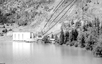
Following the war, growing power requirements led to a fast-tracking of the project, which was the largest at the time and one of the most staggering ever undertaken because of the terrain and spectacular setting of the project. Materials for the diversion dams in the Bridge River and all equipment for the powerhouse to be built at Lajoie, near Gold Bridge, had to be trucked over the 3500 feet (1,066.8 m) climb and dozens of switchbacks of the tortuous Mission Mountain Road, which was also shared with industrial and passenger traffic to and from the busy mine towns. The only access to the railhead for that road, at Shalalth, was via the rail line itself from Lillooet and, to get there, via the old pre-Trans-Canada "Cariboo Highway" from Hope to Lytton that had not been upgraded much since it was built in the 1920s.The first generator was installed at what would become Bridge River Powerhouse No. 1 in 1948, with three more generators added by 1954, giving the plant a total outpout of 180,000 kilowatts - easily the largest in the province at that time. A second tunnel, with two large penstocks, was built to supply a second powerhouse on the far side of the townsite. Work on this powerhouse (called No. 2) was carried out while the tunnel that would supply it was being bored, and it would have four generators, officially opening in 1960 with a generating capacity of 248,000 kilowatts. Geoffrey Downton, the "discoverer" of the project, was invited to push the "start" button to fire up the No. 2 generators.
Dams, powerhouses and reservoirs
The No. 1 Powerhouse is fed by four penstocks, the No. 2 Powerhouse by two much larger ones, which feed the waters of Carpenter Lake, created by Terzaghi DamTerzaghi Dam
Terzaghi Dam, located about 100 km NE of the resort of Whistler, British Columbia in western Canada, is the key diversion dam in the Bridge River Power Project. It forms the project's largest reservoir, Carpenter Lake west of Lillooet...
, from the tunnels bored through Mission Mountain. Terzaghi Dam
Terzaghi Dam
Terzaghi Dam, located about 100 km NE of the resort of Whistler, British Columbia in western Canada, is the key diversion dam in the Bridge River Power Project. It forms the project's largest reservoir, Carpenter Lake west of Lillooet...
was immediately over the pass, just below the tunnel intakes and Mission Creek, which is the valley on the north side of the pass. It was often known as Mission Dam before being officially named Terzaghi Dam, after Karl Terzaghi, the "father of modern soil mechanics" who was chief consultant on the design and construction of the dam.
An upper dam
Lajoie Dam
Lajoie Dam is the uppermost of the storage dams of the Bridge River Power Project, which is located in the southwestern Interior of British Columbia. It is located just west of the small semi-ghost town of Gold Bridge. An earthfill structure, it is 87 m and impounds c. of water in Downton Lake...
, it was the largest earthfill structure of its kind in Canada, three kilometres above the gold-mining district's supply town of Gold Bridge
Gold Bridge, British Columbia
Gold Bridge is an unincorporated community in the Bridge River Country of British Columbia, Canada. Although numbering only around 250 inhabitants, Gold Bridge is the service and supply centre for the upper basin of the Bridge River Valley, which includes recreation-residential areas at the Gun...
, was built mostly to control reservoir levels, was built at Lajoie
Lajoie Dam
Lajoie Dam is the uppermost of the storage dams of the Bridge River Power Project, which is located in the southwestern Interior of British Columbia. It is located just west of the small semi-ghost town of Gold Bridge. An earthfill structure, it is 87 m and impounds c. of water in Downton Lake...
, 60 kilometres upstream above the diversion dam
Terzaghi Dam
Terzaghi Dam, located about 100 km NE of the resort of Whistler, British Columbia in western Canada, is the key diversion dam in the Bridge River Power Project. It forms the project's largest reservoir, Carpenter Lake west of Lillooet...
. Construction of Lajoie Dam began in 1949 as a simple storage dam to regulate reservoir levels for the Bridge River plants, but in 1955 it was raised to its full height of 287 feet (87.5 m), creating Downton Lake, 534,300 acree-feet of water, elev. 2460 feet (749.8 m). A one-generator powerhouse was completed in 1957 with a capacity of 22,000 kilowatts, much of that destined to feed the power demands of the Bralorne and Pioneer Mines and their associated towns, only ten miles away, as well as other residents and towns elsewhere in the upper Bridge River valley.
Terzaghi Dam, lower in crest than Lajoie Dam at 180 feet (54.9 m) but also the most important structure in the project, was completed in 1960, creating Carpenter Lake
Carpenter Lake
Carpenter Lake, officially Carpenter Lake Reservoir, is the largest of the three reservoirs of the Bridge River Power Project, which is located in the mountains west of Lillooet, British Columbia...
. It replaced an earlier structure, a cofferdam, which had been built across the Bridge River to force its flow into the Powerhouse No. 1 diversion tunnel, which was open and operating in 1948. The rising lake waters flooded out several small ranches and homesteads in the valley, some of which dated back to the 1890s, and also the short-lived company town
Company town
A company town is a town or city in which much or all real estate, buildings , utilities, hospitals, small businesses such as grocery stores and gas stations, and other necessities or luxuries of life within its borders are owned by a single company...
of Minto City, which lay at the confluence of Gun Creek with the former Bridge River.
Seton Lake existed before the project, but a small diversion dam
Seton Dam
Seton Dam is a dam on the Seton River, 350m below the outlet of Seton Lake 5 km west of the town of Lillooet, British Columbia, Canada, and with the related Seton Canal is part of the lowest and last stage of the Bridge River Power Project...
at its outlet raised the level of the lake by about 10 feet (3 m). From the lake's outlet, a specially-built canal carries the diverted flow of the Bridge River to the last possible bit of "head" before the Fraser River, a differential of only 140' but enough to generate 42,000 kilowatts. The canal, known as Seton Canal
Seton Canal
The Seton Canal is a diversion of the flow of the Seton River from Seton Dam, just below the flow of Seton Lake, to the Seton Powerhouse on the Fraser River at the town of Lillooet, British Columbia, Canada...
, is highly unusual in that it bridges both Seton and Cayoosh Creeks before being briefly tunneled through a low rock bluff to the Seton Powerhouse
Seton Powerhouse
The Seton Powerhouse is a hydroelectric generating station on the Fraser River just below the confluence of the Seton River at the town of Lillooet, British Columbia, Canada. The powerhouse is fed by the Seton Canal, a 5 km diversion of the flow of the Seton River which begins at Seton Dam,...
, which is right on the Fraser River just below the town of Lillooet.
BC Hydro assumes control
The British Columbia Electric CompanyBritish Columbia Electric Railway
The British Columbia Electric Railway was a historic Canadian railway which operated in southwestern British Columbia.Originally the parent company, and later a division, of BC Electric, the BCER operated public transportation in southwestern British Columbia from its establishment in the...
, successor to the Bridge River Power Company on this project and the main electrical utility in the province, was taken over and nationalized by the British Columbia government in 1958 as BC Hydro
BC Hydro
The BC Hydro and Power Authority is a Canadian electric utility in the province of British Columbia generally known simply as BC Hydro. It is the main electric distributor, serving 1.8 million customers in most areas, with the exception of the Kootenay region, where FortisBC, a subsidiary of Fortis...
, a Crown Corporation.
Structures
- Lajoie DamLajoie DamLajoie Dam is the uppermost of the storage dams of the Bridge River Power Project, which is located in the southwestern Interior of British Columbia. It is located just west of the small semi-ghost town of Gold Bridge. An earthfill structure, it is 87 m and impounds c. of water in Downton Lake...
and Powerhouse - Terzaghi DamTerzaghi DamTerzaghi Dam, located about 100 km NE of the resort of Whistler, British Columbia in western Canada, is the key diversion dam in the Bridge River Power Project. It forms the project's largest reservoir, Carpenter Lake west of Lillooet...
- Bridge River Powerhouses No. 1 and No. 2
- Seton DamSeton DamSeton Dam is a dam on the Seton River, 350m below the outlet of Seton Lake 5 km west of the town of Lillooet, British Columbia, Canada, and with the related Seton Canal is part of the lowest and last stage of the Bridge River Power Project...
and CanalSeton CanalThe Seton Canal is a diversion of the flow of the Seton River from Seton Dam, just below the flow of Seton Lake, to the Seton Powerhouse on the Fraser River at the town of Lillooet, British Columbia, Canada... - Seton PowerhouseSeton PowerhouseThe Seton Powerhouse is a hydroelectric generating station on the Fraser River just below the confluence of the Seton River at the town of Lillooet, British Columbia, Canada. The powerhouse is fed by the Seton Canal, a 5 km diversion of the flow of the Seton River which begins at Seton Dam,...
(aka Lillooet Powerhouse)
Environmental impact
A full official assessment of this project's impact on the local and provincial environment has never been completed, and was not required at the time of its construction. Seton Lake, once pristine and renowned for its crystalline sky-blue colour, was turned cold and opaque by the diverted waters of the Bridge River, which are glacial and milky-green in colour.Damage to the fishery on both river systems involved was incalculable. Although a fish ladder was built at the Seton diversion, it is generally conceded that the project virtually wiped out the entire Bridge River salmon runs, once one of the river's largest and most important and, in so doing, caused a local famine among the area's populous fishery-dependent native bands. It was hoped that the returning Bridge River salmon would follow the smell of Bridge River water up the Seton-Cayoosh system, where a fish ladder and also a set of hatchery channels were constructed, but the fish attempted to swim directly into the tailrace of the Lillooet Powerhouse. To ameliorate this, a tunnel was bored through the moraine at the foot of Seton Lake to feed water from Cayoosh Creek into the lake near the diversion, so that the mix of waters coming out of Cayoosh Creek's confluence with the Fraser would confuse the fish and some of them would choose the creek instead, thereby finding the hatchery. This was of mixed success, and as far as many locals concerned only served to make the water at the public beach at the foot of Seton Lake colder than it already was.
Unscheduled releases of water from Terzaghi Dam during spawning seasons in the 1990s caused a furor amongst local residents and First Nations, with a major investigation launched and Hydro now operating under strict rules for releasing water.
The most immediate and visible environmental impact of the project, however, was the inundation of the upper Bridge River Valley. Formerly a serpentine flat-bottomed valley framed by its tributary canyons and ranges, the valley had been home to a number of prospectors, settlers, lodges and others who were forced from their homes by the rising waters of Carpenter Lake, which also drowned what was left of Minto City (there were no residents in the area of what is now Downton Lake). Acrimony over the evictions continued for many years, and feelings from old-timers about the fate of their valley remain strong among their offspring. Much of Carpenter Lake today is mudflat when reservoir levels are low, and for many years it was a stark reminder of older environmental standards, with vast forests of dead trees sticking out of the frigid, milky-blue glacial waters. Some feel that the shift in temperature regimes in the two river basins affected local climate patterns, with the upper valley now more moderate in climate and the Seton valley considerably cooler.
Programs in the 1980s to engage prisoners and others in the removal of these trees were launched during low-water levels, and the lake today is largely safe for boating, and while stocked for fishing it is still unadvisable for swimming due to its icy-cold water.
See also
- ShalalthShalalth, British ColumbiaShalalth, pop. c. 400, is one of the main communities of the Seton Lake Band of the St'at'imc Nation and location of the two main powerhouses of the Bridge River Power Project....
- Seton PortageSeton Portage, British ColumbiaSeton Portage is a historic rural community in British Columbia, Canada, that is about 25 km west of Lillooet, located between Seton Lake and Anderson Lake. "The Portage" was formed about 10,000 years ago when the flank of the Cayoosh Range, which is the south flank of the valley, let go and...
- LillooetLillooet, British ColumbiaLillooet is a community on the Fraser River in western Canada, about up the British Columbia Railway line from Vancouver. Situated at an intersection of deep gorges in the lee of the Coast Mountains, it has a dry climate- of precipitation is recorded annually at the town's weather station,...
- Minto CityMinto City, British ColumbiaMinto City, often called just Minto, sometimes Minto Mines or Minto Mine, was a gold mining town in the Bridge River Valley of British Columbia from 1930 to 1936, located at the confluence of that river with Gun Creek, one of its larger tributaries...