

Spruce Lake Protected Area
Encyclopedia
Vancouver
Vancouver is a coastal seaport city on the mainland of British Columbia, Canada. It is the hub of Greater Vancouver, which, with over 2.3 million residents, is the third most populous metropolitan area in the country,...
. The area had been the subject of an ongoing preservationist controversy since the 1930s. Formerly known variously as the Southern Chilcotin Mountains Provincial Park, Southern Chilcotins, and also as South Chilcotin Provincial Park. In 2007, its status as a provincial park was downgraded to protected area.
Recreational activities included camping, hiking, cycling, swimming, fishing and hunting. There were walk-in wilderness camping sites. Wildlife in the protected area include grizzly bear
Grizzly Bear
The grizzly bear , also known as the silvertip bear, the grizzly, or the North American brown bear, is a subspecies of brown bear that generally lives in the uplands of western North America...
, California bighorn sheep
Bighorn Sheep
The bighorn sheep is a species of sheep in North America named for its large horns. These horns can weigh up to , while the sheep themselves weigh up to . Recent genetic testing indicates that there are three distinct subspecies of Ovis canadensis, one of which is endangered: Ovis canadensis sierrae...
and wolverine
Wolverine
The wolverine, pronounced , Gulo gulo , also referred to as glutton, carcajou, skunk bear, or quickhatch, is the largest land-dwelling species of the family Mustelidae . It is a stocky and muscular carnivore, more closely resembling a small bear than other mustelids...
.
In June 2010, Bill 15 - created the South Chilcotin Mountains Park, a "Class A" park of 56,796 hectares from Spruce Lake Protected Area. The remaining approximately 14,550 hectares were set aside for tourism
Tourism
Tourism is travel for recreational, leisure or business purposes. The World Tourism Organization defines tourists as people "traveling to and staying in places outside their usual environment for not more than one consecutive year for leisure, business and other purposes".Tourism has become a...
and mining
Mining
Mining is the extraction of valuable minerals or other geological materials from the earth, from an ore body, vein or seam. The term also includes the removal of soil. Materials recovered by mining include base metals, precious metals, iron, uranium, coal, diamonds, limestone, oil shale, rock...
, but commercial logging
Logging
Logging is the cutting, skidding, on-site processing, and loading of trees or logs onto trucks.In forestry, the term logging is sometimes used in a narrow sense concerning the logistics of moving wood from the stump to somewhere outside the forest, usually a sawmill or a lumber yard...
is still prohibited. The bill also confirmed the implementation of the 2004 decision for mining/tourism zones in the Lillooet Land and Resource Management Plan area.
Background
The area was designated as a protected areaProtected area
Protected areas are locations which receive protection because of their recognised natural, ecological and/or cultural values. There are several kinds of protected areas, which vary by level of protection depending on the enabling laws of each country or the regulations of the international...
by the British Columbis provincial government in 2001, and then established as a Provincial Park by then Minister of Water, Land and Air Protecltion Minister Joyce Murray in 2004, with park boundaries including 70% of the protected area and limited resource extraction allowed in the remaining area on the protected area's periphery.
The protected area designation resulted from the Lillooet Land and Resource Management Plan (LRMP), in which local communities, environmental, recreation and resource interests were attempted to be addressed. Even though it is not in the Chilcotin District
Chilcotin District
The Chilcotin District of British Columbia is usually known simply as "the Chilcotin", and also in speech commonly as "the Chilcotin Country" or simply Chilcotin. It is a plateau and mountain region in British Columbia on the inland lea of the Coast Mountains on the west side of the Fraser River....
proper, the area has been called the "South Chilcotins" since about 1980 when a group of conservationists started to promote the area for protection as a park. The South Chilcotin name is derived from its geographic position in the Chilcotin Ranges
Chilcotin Ranges
The Chilcotin Ranges are a subdivision of the Pacific Ranges of the Coast Mountains . They lie on the inland lea of the Pacific Ranges, abutting the Interior Plateau of British Columbia...
, into the Bridge River Country
Bridge River Country
The Bridge River Country is a historic geographic region and mining district in the Interior of British Columbia, Canada, lying between the Fraser Canyon and the valley of the Lillooet River, south of the Chilcotin Plateau and north of the Lillooet Ranges...
where the park is located. Bert Brink, one of British Columbis's most renowned naturalist, advocated for the conservation of this area for over sixty years and lived to see it become a park, before he died in 2007.
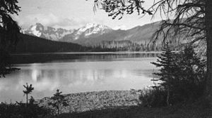
Location and topography
The protected area was located on the inland lea of the Pacific RangesPacific Ranges
The Pacific Ranges are the southernmost subdivision of the Coast Mountains portion of the Pacific Cordillera. Located entirely within British Columbia, Canada, they run northwest from the lower stretches of the Fraser River to Bella Coola, north of which are the Kitimat Ranges.The Pacific Ranges...
of the Coast Mountains
Coast Mountains
The Coast Mountains are a major mountain range, in the Pacific Coast Ranges, of western North America, extending from southwestern Yukon through the Alaska Panhandle and virtually all of the Coast of British Columbia. They are so-named because of their proximity to the sea coast, and are often...
, on the north flank of the Bridge River Country
Bridge River
The Bridge River is, or was, a major tributary of British Columbia's Fraser River, entering that stream about six miles upstream from the town of Lillooet.-Name:Its name in the Lillooet language is Xwisten , sometimes spelled Nxwisten or Nxo-isten)...
and the Chilcotin Country
Chilcotin District
The Chilcotin District of British Columbia is usually known simply as "the Chilcotin", and also in speech commonly as "the Chilcotin Country" or simply Chilcotin. It is a plateau and mountain region in British Columbia on the inland lea of the Coast Mountains on the west side of the Fraser River....
to the north. It adjoined Big Creek Provincial Park
Big Creek Provincial Park
Big Creek Provincial Park is a provincial park in British Columbia, Canada.It is adjoined on the south by the Spruce Lake Protected Area and on the west by Ts'il?os Provincial Park. Neighbouring on the east is the Churn Creek Protected Area.- References :...
and Ts'il?os Provincial Park
Ts'il?os Provincial Park
Ts'il?os Provincial Park is a provincial park in British Columbia, Canada. Ts'il?os is the official BC Parks designation for this provincial park, though sometimes it is written as "Ts'il-os", "Ts'yl-os", or "Tsylos"...
, which border it on the north and northwest, respectively. Part of the larger subrange of the Pacific Ranges
Pacific Ranges
The Pacific Ranges are the southernmost subdivision of the Coast Mountains portion of the Pacific Cordillera. Located entirely within British Columbia, Canada, they run northwest from the lower stretches of the Fraser River to Bella Coola, north of which are the Kitimat Ranges.The Pacific Ranges...
known as the Chilcotin Ranges
Chilcotin Ranges
The Chilcotin Ranges are a subdivision of the Pacific Ranges of the Coast Mountains . They lie on the inland lea of the Pacific Ranges, abutting the Interior Plateau of British Columbia...
, the area was partially protected in the 1990s after 60 years of debate and controversy.
Controversy
It was the object of a protracted quarrel between preservationists and resource development which first began in the 1930s when prospectors and guide-outfitters dedicated to its natural beauty proposed it for preservation status. Charlie Cunningham, whose career as a wildlife film-maker began in this area, was a driving force in the original movement for preservation. The Charlie Cunningham Wilderness proposal was revised in the 1970s as the Spruce Lake-Eldorado park proposal, and also as the Spruce Lake Management Planning Unit, but as land-use plans impinged on the proposed park area these names were abandoned.The area's unique and distinct landscape and ecology, different from the rest of the Chilcotin Ranges
Chilcotin Ranges
The Chilcotin Ranges are a subdivision of the Pacific Ranges of the Coast Mountains . They lie on the inland lea of the Pacific Ranges, abutting the Interior Plateau of British Columbia...
or the rest of the Bridge River Country
Bridge River
The Bridge River is, or was, a major tributary of British Columbia's Fraser River, entering that stream about six miles upstream from the town of Lillooet.-Name:Its name in the Lillooet language is Xwisten , sometimes spelled Nxwisten or Nxo-isten)...
, was what made it stand out for protection amid a region already wild and extremely beautiful before logging
Logging
Logging is the cutting, skidding, on-site processing, and loading of trees or logs onto trucks.In forestry, the term logging is sometimes used in a narrow sense concerning the logistics of moving wood from the stump to somewhere outside the forest, usually a sawmill or a lumber yard...
and hydroelectric development transformed the valley to the south.
Many environmentalist hope that the creation of Ts'ilos
Ts'il?os Provincial Park
Ts'il?os Provincial Park is a provincial park in British Columbia, Canada. Ts'il?os is the official BC Parks designation for this provincial park, though sometimes it is written as "Ts'il-os", "Ts'yl-os", or "Tsylos"...
and Big Creek Provincial Park
Big Creek Provincial Park
Big Creek Provincial Park is a provincial park in British Columbia, Canada.It is adjoined on the south by the Spruce Lake Protected Area and on the west by Ts'il?os Provincial Park. Neighbouring on the east is the Churn Creek Protected Area.- References :...
s will help shore up the protection of the South Chilcotin Provincial Park which remained vulnerable to government review. Hunting guide Ted (Chilco) Choate of Gaspard Lake, on the Chilcotin Plateau
Chilcotin District
The Chilcotin District of British Columbia is usually known simply as "the Chilcotin", and also in speech commonly as "the Chilcotin Country" or simply Chilcotin. It is a plateau and mountain region in British Columbia on the inland lea of the Coast Mountains on the west side of the Fraser River....
has joined in the call to combine all three parks, plus the Churn Creek Protected Area
Churn Creek Protected Area
The Churn Creek Protected Area, is a provincial protected area in British Columbia, Canada. It is a mix of dryland canyon and steppe and adjoining rangeland flanking the canyon of Churn Creek and that stream's confluence with the Fraser River at the northern apex of the Camelsfoot Range. The...
to the northeast, plus some of the surrounding country and the deep, much higher heart of the Pacific Ranges
Pacific Ranges
The Pacific Ranges are the southernmost subdivision of the Coast Mountains portion of the Pacific Cordillera. Located entirely within British Columbia, Canada, they run northwest from the lower stretches of the Fraser River to Bella Coola, north of which are the Kitimat Ranges.The Pacific Ranges...
into a National Park
National park
A national park is a reserve of natural, semi-natural, or developed land that a sovereign state declares or owns. Although individual nations designate their own national parks differently A national park is a reserve of natural, semi-natural, or developed land that a sovereign state declares or...
. Industry and government remain publicly committed to shared use and sustainable planning.
First Nations History
Historically this region was the hunting territory of Chief Hunter JackChief Hunter Jack
Chief Hunter Jack was a 19th C. chief of the Lakes Lillooet . His name in St'at'imcets, the Lillooet language, is cited in one source as Tash Poli....
of the Lakes Lillooet
St'at'imc
The St'át'imc are an Interior Salish people located in the southern Coast Mountains and Fraser Canyon region of the Interior of the Canadian province of British Columbia.St'át'imc culture displayed many features typical of Northwest Coast peoples: the...
, whose big-game hunting business shared the region with hunters of the Tsilhqot'in
Tsilhqot'in
The Tsilhqot'in are a Northern Athabaskan First Nations people that live in British Columbia, Canada...
people. The shared use of the area north of the Bridge River
Bridge River
The Bridge River is, or was, a major tributary of British Columbia's Fraser River, entering that stream about six miles upstream from the town of Lillooet.-Name:Its name in the Lillooet language is Xwisten , sometimes spelled Nxwisten or Nxo-isten)...
and Gun Creek was part of the settlement of an early 19th Century peace which had ended a long and bloody war between Hunter Jack's people and the Tsilhqot'in
Tsilhqot'in
The Tsilhqot'in are a Northern Athabaskan First Nations people that live in British Columbia, Canada...
.
Trails from the Bridge River Country
Bridge River
The Bridge River is, or was, a major tributary of British Columbia's Fraser River, entering that stream about six miles upstream from the town of Lillooet.-Name:Its name in the Lillooet language is Xwisten , sometimes spelled Nxwisten or Nxo-isten)...
led over the region to Taseko Lake
Taseko Lakes
The Taseko Lakes are a pair of lakes, Upper Taseko Lake and Lower Taseko Lake, which are expansions of the upper Taseko River in the southern Chilcotin District of the Central Interior of British Columbia, Canada...
and Chilko Lake
Chilko Lake
Chilko Lake is a 180 km² lake in west-central British Columbia, at the head of the Chilko River on the Chilcotin Plateau. The lake is about 65 km long, with a southwest arm 10 km long. It is one of the largest lakes by volume in the province because of its great depth, and the...
in the Chilcotin Country
Chilcotin District
The Chilcotin District of British Columbia is usually known simply as "the Chilcotin", and also in speech commonly as "the Chilcotin Country" or simply Chilcotin. It is a plateau and mountain region in British Columbia on the inland lea of the Coast Mountains on the west side of the Fraser River....
, and also east across the Camelsfoot Range
Camelsfoot Range
The Camelsfoot Range is a sub-range of the Chilcotin Ranges subdivision of the Pacific Ranges of the Coast Mountains in British Columbia.* The range is c...
to the Fraser River
Fraser River
The Fraser River is the longest river within British Columbia, Canada, rising at Fraser Pass near Mount Robson in the Rocky Mountains and flowing for , into the Strait of Georgia at the city of Vancouver. It is the tenth longest river in Canada...
near Big Bar.