
New York State Route 30
Encyclopedia
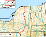
New York State Route 30 (NY 30) is a state highway
in the central part of New York
in the United States. It extends for 300.71 miles (483.94 km) from an interchange with NY 17
in the Southern Tier
to the Canadian border in the state's North Country
, where it continues into Quebec
as Route 138
. On a regional level, the route serves to connect the Catskill Park to the Adirondack Park. In the latter, NY 30 is known as the Adirondack Trail. Aside from the state parks, the route serves the city of Amsterdam
(where it meets the New York State Thruway
) and several villages.
NY 30 was assigned in the 1930 renumbering of state highways in New York to most of its modern routing south of Wells, replacing a series of designations that had been assigned to the highway in the 1920s. The portion of what is now NY 30 north of Speculator
was initially part of NY 10
. When that route was truncated to Arietta
ca. 1960, NY 30 was extended northward over NY 10's former alignment by way of an overlap with NY 8
.
(NYSDOT) maintains all but 0.97 miles (1.56 km) of NY 30's 301 miles (484 km) alignment. The only section not maintained by the state is located in the city of Amsterdam, where the route is locally maintained from Prospect Street (two blocks north of NY 67
) to the northern city line.
and the Beaverkill River
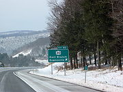
. The route follows the East Branch northeast to Downsville
, where it meets NY 206
. NY 206 follows NY 30 across the East Branch into Catskill Park, where the routes split near Brock Mountain. NY 30 exits the park and crosses over the river once more soon after. Near Margaretville
, NY 30 briefly overlaps NY 28
before turning northward toward Roxbury
, where the route passes the John Burroughs Memorial State Historic Site
. New York Governor David Paterson
designated the stretch of NY 30 within Margaretville the "David C. Brinkerhoff Memorial Highway", after the New York State Trooper who was slain in pursuit of Travis Trimm near the village on April 25, 2007.
 From Roxbury, NY 30 follows the East Branch to Grand Gorge in northeastern Delaware County
, where the East Branch comes to an end amidst the mountains. NY 30, meanwhile, intersects NY 23
in the center of the hamlet.
 North of Grand Gorge, NY 30 crosses into Schoharie County
and intersects NY 990V
, one of four reference routes in New York
erroneously signed as a touring route, near the northeastern edge of the Schoharie Reservoir
in Gilboa
. From NY 990V northward, NY 30 follows the Schoharie Creek
through Schoharie County to Middleburgh
, where it intersects NY 145
. To the north in Schoharie
, NY 30 meets NY 443
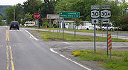
before splitting into NY 30 and NY 30A
north of the village, with Schoharie Creek largely following NY 30A. While NY 30A connects to Interstate 88
(I-88) by way of an interchange a short distance to the north, NY 30 has no connection to the freeway. Just past I-88, NY 30 intersects NY 7
. Shortly after passing NY 7, NY 30 enters Schenectady County
.
. Near the northeastern corner of the county, NY 30 enters the city of Amsterdam
. The route meets the New York State Thruway
(I-90) and NY 5S
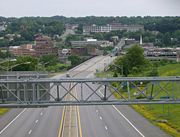
via separate interchanges before heading downhill as a four-lane divided highway approaching the Mohawk River
(here part of the Erie Canal
). Historically, the bridge over the river was a straight line to Market Street, which is visible as one approaches northbound. Segments of downtown Market Street remain in use today. With the 1977 creation of the Amsterdam Mall, NY 30, together with NY 5 and NY 67, were re-routed onto splits. After the splits rejoin, NY 30 continues on Market Street and leaves the city and, for all purposes, the county.
 In adjacent Fulton County
, NY 30 crosses NY 29
near Broadalbin
, then curves gently to the east after an intersection with County Route 155 (CR 155), a historical routing of NY 29. 0.25 mile (0.402335 km), NY 30 turns left toward Mayfield
; CR 155 continues eastward. The concurrency between the two routes is unsigned.
NY 30 historically followed School Street through the village of Mayfield. The new routing has it heading toward Riceville, where NY 30A
rejoins NY 30. Here, the Adirondack Trail begins as NY 30 turns right, following the right-of-way of NY 30A into Adirondack Park shortly before entering Mayfield.
 NY 30 runs through the Adirondacks, accessing communities such as Speculator
, Blue Mountain Lake
, and Tupper Lake as a scenic byway named the Adirondack Trail. From Wells
to Speculator, NY 30 is concurrent to NY 8
, then with NY 28
from Indian Lake
to Blue Mountain Lake. Between Blue Mountain Lake and Long Lake
, NY 30 is concurrent with the eastern third of NY 28N
.
Near Tupper Lake, it skirts the boundary between Franklin
and Saint Lawrence for a considerable distance before entering Tupper Lake and intersecting NY 3
. The two routes overlap to Harrietstown
, where NY 30 splits from NY 3 and heads north along a series of lakes, including Upper Saranac Lake
and Meacham Lake. North of Duane
, NY 30 exits Adirondack Park and heads north towards Malone
. Within the village, NY 30 briefly overlaps US 11. The Adirondack Trail ends at the east end of the overlap. The route continues north out of the village to the Canadian border in Constable
, where it becomes Route 138
upon entering Quebec
.
The stretch of Route 30 from Middleburgh to Schoharie was also once part of the Middleburgh and Schoharie Plank Road.
and Grand Gorge in the town of Roxbury
, what is now NY 30 was designated as part of NY 19. From Mayfield
north to Malone
, most of the current routing of NY 30 carried a designation. The portion from the modern junction of NY 30 and NY 30A in Mayfield to Speculator
was part of NY 54. From Speculator to Indian Lake
, NY 30 was the northernmost segment of NY 80
. Between Indian Lake and Long Lake
, NY 30 comprised the western half of NY 10A. Past Long Lake, NY 30 was part of NY 10
north to the modern junction of NY 30 and NY 186
west of Harrietstown
. From NY 186 to modern NY 86
in Paul Smiths
, the present alignment of NY 30 was unnumbered. Between Paul Smiths and Malone, NY 30 was part of NY 3
. The remainder of NY 30 was unnumbered.
In the 1930 renumbering, NY 30 was largely assigned to its current alignment between the Hancock hamlet of East Branch and Wells
, where it terminated at NY 8
. Past Wells, the modern alignment of NY 30 was designated as NY 8 to Spectator and as NY 10
north to the Canadian border. NY 10 was truncated southward to NY 8 in Arietta
ca. 1960, at which time NY 30 was extended north to Quebec
along the former alignment of NY 10.
 NY 30 has been realigned in two areas along its routing. The first realignment was in the Schoharie Valley
near the hamlets of Breakabeen
and Fultonham
. NY 30 was originally routed along the base of Toepath Mountain near Fultonham and along a pair of village streets in Breakabeen. In the 1950s, a proposal was made to reroute NY 30 onto a new routing in the base of the valley surrounding Schoharie Creek
. The proposal was approved, and the new alignment of NY 30 opened ca. 1970. The former routing of NY 30 from Max V. Shaul State Park
near Breakabeen to Fultonham, still visible from the modern alignment of the route, was closed to the public and guardrails were installed to stop motor traffic from using the route. However, biking and walking was still allowed, and the old highway is now a 1.5 miles (2.4 km) long trail known as "Old Route 30". The trail is not maintained; thus, the quality of the blacktop along Old Route 30 has deteriorated over the years. There are significant potholes and overhanging trees, but the path is still traversable.
The second realignment of NY 30 was in the vicinity of the village of Northville
. NY 30 originally entered the village by way of Bridge Street and followed Bridge, Main, and Reed Streets through the village. It continued along the eastern bank of the Great Sacandaga Lake
on what is now Old State Road and Old Northville Road and rejoined its modern alignment in the town of Hope
. The route was realigned ca. 1961 to follow a new highway along the western lakeshore, bypassing Northville entirely. The portion of Bridge Street from NY 30 to the Northville village line remains state-maintained as NY 920H, an unsigned reference route 0.23 mile (0.3701482 km) in length. Farther north, the portion of Old Northville Road from the Fulton
–Hamilton
county line to its junction with NY 30 is maintained by Hamilton County as CR 15.
 NY 30A
(34.86 miles or 56.1 km) is a loop of NY 30, running west of NY 30 from north of Schoharie
to south of Mayfield
through Fultonville
, Fonda
, Johnstown
, and Gloversville
. It was assigned in the late 1950s.
State highway
State highway, state road or state route can refer to one of three related concepts, two of them related to a state or provincial government in a country that is divided into states or provinces :#A...
in the central part of New York
New York
New York is a state in the Northeastern region of the United States. It is the nation's third most populous state. New York is bordered by New Jersey and Pennsylvania to the south, and by Connecticut, Massachusetts and Vermont to the east...
in the United States. It extends for 300.71 miles (483.94 km) from an interchange with NY 17
New York State Route 17
New York State Route 17 is a state highway that extends for through the Southern Tier and Downstate regions of New York in the United States...
in the Southern Tier
Southern Tier
The Southern Tier is a geographical term that refers to the counties of New York State west of the Catskill Mountains along the northern border of Pennsylvania. It is a loosely defined term that generally includes the counties that border Pennsylvania west of Delaware County inclusive...
to the Canadian border in the state's North Country
North Country, New York
The North Country is a region of the U.S. state of New York that encompasses the state's extreme northern frontier, bordering Lake Ontario on the west, the Saint Lawrence River and the Canadian provinces of Ontario and Quebec on the north and northwest, and Lake Champlain and Vermont on the east...
, where it continues into Quebec
Quebec
Quebec or is a province in east-central Canada. It is the only Canadian province with a predominantly French-speaking population and the only one whose sole official language is French at the provincial level....
as Route 138
Quebec route 138
Route 138 is a major highway in the Canadian province of Quebec, following the entire north shore of the Saint Lawrence River past Montreal to the eastern terminus in Natashquan on the Gulf of Saint Lawrence. The western terminus is in Elgin, at the border with New York State south-west of Montreal...
. On a regional level, the route serves to connect the Catskill Park to the Adirondack Park. In the latter, NY 30 is known as the Adirondack Trail. Aside from the state parks, the route serves the city of Amsterdam
Amsterdam (city), New York
Amsterdam is a city located in Montgomery County, New York, USA. As of the 2010 census, the city had a total population of 18,620. The name is derived from the city of Amsterdam in the Netherlands....
(where it meets the New York State Thruway
New York State Thruway
The New York State Thruway is a system of limited-access highways located within the state of New York in the United States. The system, known officially as the Governor Thomas E. Dewey Thruway for former New York Governor Thomas E. Dewey, is operated by the New York State Thruway Authority and...
) and several villages.
NY 30 was assigned in the 1930 renumbering of state highways in New York to most of its modern routing south of Wells, replacing a series of designations that had been assigned to the highway in the 1920s. The portion of what is now NY 30 north of Speculator
Speculator, New York
Speculator is a village in Hamilton County, New York, United States. The population was 348 at the 2000 census. The village is named after a nearby Speculator Mountain....
was initially part of NY 10
New York State Route 10
New York State Route 10 is a north–south state highway in the Central New York and North Country regions of New York in the United States. It extends for from the Quickway in Deposit, Delaware County to NY 8 at Higgins Bay, a hamlet in the Hamilton County town of Arietta...
. When that route was truncated to Arietta
Arietta, New York
Arietta is a town in Hamilton County, New York, United States. The population was 293 at the 2000 census. The town was named after the mother of one of the first settlers, Rensselaer Van Rennslaer...
ca. 1960, NY 30 was extended northward over NY 10's former alignment by way of an overlap with NY 8
New York State Route 8
New York State Route 8 is a state highway in the central part of New York in the United States. It runs in a southwest-to-northeast direction from the Southern Tier to the northern part of Lake George. The southern terminus of the route is at an interchange with NY 17 in the town of...
.
Route description
The New York State Department of TransportationNew York State Department of Transportation
The New York State Department of Transportation is responsible for the development and operation of highways, railroads, mass transit systems, ports, waterways and aviation facilities in the U.S...
(NYSDOT) maintains all but 0.97 miles (1.56 km) of NY 30's 301 miles (484 km) alignment. The only section not maintained by the state is located in the city of Amsterdam, where the route is locally maintained from Prospect Street (two blocks north of NY 67
New York State Route 67
New York State Route 67 is an east–west state highway in eastern New York in the United States. The western terminus of the route is at an intersection with NY 5 in the town of St. Johnsville...
) to the northern city line.
Hancock to Schoharie
NY 30 begins at an interchange with NY 17 in the town of Hancock adjacent to the confluence of the East Branch of the Delaware RiverEast Branch Delaware River
The East Branch Delaware River, approximately 75 miles long in the U.S. state of New York, is one of two branches, along with the West Branch, that join to form the Delaware River. It flows through a mountainous area on the southwestern edge of the Catskill Park. For a long stretch it serves...
and the Beaverkill River
Beaverkill River
The Beaver Kill, sometimes written as the Beaverkill or Beaverkill River, is a tributary of the East Branch of the Delaware River, approximately long, in the U.S. State of New York. The kill drains a area of the Catskill Mountains and has long been celebrated as one of the most famous trout...
. The route follows the East Branch northeast to Downsville
Downsville, New York
Downsville, New York is a hamlet and former village within the town of Colchester in Delaware County, New York.It is the site of the Downsville Bridge, a covered bridge and the historic Union Free School....
, where it meets NY 206
New York State Route 206
New York State Route 206 is a state highway in the Southern Tier of New York, United States. It runs through some lightly populated regions along the state's southern border, from Central New York to the Catskills. It begins near a busy intersection with Interstate 81 at Whitney Point...
. NY 206 follows NY 30 across the East Branch into Catskill Park, where the routes split near Brock Mountain. NY 30 exits the park and crosses over the river once more soon after. Near Margaretville
Margaretville, New York
Margaretville is a village in Delaware County, New York, United States. The population was 643 at the 2000 census.The Village of Margaretville is in the Town of Middletown. The village is on the border of the Catskill Park...
, NY 30 briefly overlaps NY 28
New York State Route 28
New York State Route 28 is a state highway extending for in the shape of a "C" between the Hudson Valley city of Kingston and southern Warren County in the U.S. state of New York. Along the way, it intersects several major routes, including Interstate 88 , U.S. Route 20 , and the...
before turning northward toward Roxbury
Roxbury, New York
Roxbury is a town in Delaware County, New York, United States. The population was 2,509 at the 2000 census.The Town of Roxbury is at the eastern end of the county.- History :...
, where the route passes the John Burroughs Memorial State Historic Site
Woodchuck Lodge
Woodchuck Lodge, also known as John Burroughs Memorial State Historic Site is in Roxbury in the western Catskills of Delaware County, New York, was a summertime home of naturalist John Burroughs. He is buried here, at the foot of a rock on which he played as a child...
. New York Governor David Paterson
David Paterson
David Alexander Paterson is an American politician who served as the 55th Governor of New York, from 2008 to 2010. During his tenure he was the first governor of New York of African American heritage and also the second legally blind governor of any U.S. state after Bob C. Riley, who was Acting...
designated the stretch of NY 30 within Margaretville the "David C. Brinkerhoff Memorial Highway", after the New York State Trooper who was slain in pursuit of Travis Trimm near the village on April 25, 2007.
Delaware County, New York
Delaware County is a county located in the U.S. state of New York. As of 2010 the population was 47,980. The county seat is Delhi. It is named after the Delaware River, which was named in honor of Thomas West, 3rd Baron De La Warr, appointed governor of Virginia in 1609.-History:When counties...
, where the East Branch comes to an end amidst the mountains. NY 30, meanwhile, intersects NY 23
New York State Route 23
New York State Route 23 is an east–west state highway in the eastern portion New York in the United States. It extends for from an intersection with NY 26 in the Central New York town of Cincinnatus to the Massachusetts state line in the Berkshire Mountains, where it continues east as...
in the center of the hamlet.
Schoharie County, New York
As of the census of 2000, there were 31,582 people, 11,991 households and 8,177 families residing in the county. The population density was 51 people per square mile . There were 15,915 housing units at an average density of 26 per square mile...
and intersects NY 990V
New York State Route 990V
New York State Route 990V is a long east–west reference route in Schoharie County, New York, United States. The western terminus of the route is at an intersection with NY 30 in Gilboa. Its eastern terminus is at County Route 18 in Conesville, where the road continues east as...
, one of four reference routes in New York
New York
New York is a state in the Northeastern region of the United States. It is the nation's third most populous state. New York is bordered by New Jersey and Pennsylvania to the south, and by Connecticut, Massachusetts and Vermont to the east...
erroneously signed as a touring route, near the northeastern edge of the Schoharie Reservoir
Schoharie Reservoir
The Schoharie Reservoir is a small reservoir in the Catskill Mountains of New York State that was created to be one of 19 reservoirs that supplies New York City with water. It was created by impounding Schoharie Creek...
in Gilboa
Gilboa, New York
Gilboa is a town in Schoharie County, New York, United States. The population was 1,215 at the 2000 census.The Town of Gilboa is in the south part of the county and is southwest of Albany.- History :The town was first settled around 1760....
. From NY 990V northward, NY 30 follows the Schoharie Creek
Schoharie Creek
Schoharie Creek in New York, USA flows north from the foot of Indian Head Mountain in the Catskill Mountains through the Schoharie Valley to the Mohawk River. It is twice impounded north of Prattsville to create New York City's Schoharie Reservoir and the Blenheim-Gilboa Power Project.Two notable...
through Schoharie County to Middleburgh
Middleburgh (village), New York
Middleburgh is a village in Schoharie County, New York, USA. The population was 1,398 at the 2000 census.The Village of Middleburgh is in the southwest part of the Town of Middleburgh and is west of Albany.- History :...
, where it intersects NY 145
New York State Route 145
New York State Route 145 is a state highway in eastern New York in the United States. The highway extends for from NY 23 in the Greene County town of Cairo to U.S. Route 20 in the Schoharie County town of Sharon. Along the way, NY 145 intersects NY 30 in Middleburgh and...
. To the north in Schoharie
Schoharie (village), New York
Schoharie is a village in Schoharie County, New York, USA. The population was 1,030 at the 2000 census. It is the county seat of Schoharie County...
, NY 30 meets NY 443
New York State Route 443
New York State Route 443 is an east–west state highway in the Capital District of New York in the United States. The route begins at an intersection with NY 30 in the town of Schoharie and ends later at a junction with U.S. Route 9W and US 20 in the city of Albany...
before splitting into NY 30 and NY 30A
New York State Route 30A
New York State Route 30A is a state highway in the Capital District of New York in the United States. It serves as a westerly alternate route of NY 30 from near the Schoharie County village of Schoharie to the Fulton County hamlet of Riceville, south of the village of Mayfield...
north of the village, with Schoharie Creek largely following NY 30A. While NY 30A connects to Interstate 88
Interstate 88 (east)
Interstate 88 is an intrastate Interstate Highway entirely within the U.S. state of New York. Its western end is at Interstate 81 in Binghamton and its eastern end is at Interstate 90 in Schenectady. It serves as an important connector route from Albany to Binghamton, Elmira , and...
(I-88) by way of an interchange a short distance to the north, NY 30 has no connection to the freeway. Just past I-88, NY 30 intersects NY 7
New York State Route 7
New York State Route 7 is a 180-mile long New York State Highway that runs from the New York/Pennsylvania border south of Binghamton, New York to the New York/Vermont border east of Hoosick. Most of the road runs along the Susquehanna Valley, closely paralleling Interstate 88 throughout...
. Shortly after passing NY 7, NY 30 enters Schenectady County
Schenectady County, New York
Schenectady County is a county located in the U.S. state of New York. As of the 2010 census, the population was 154,727. It is part of the Albany-Schenectady-Troy Metropolitan Statistical Area. The county seat is Schenectady. The name is from a Mohawk Indian word meaning "on the other side of the...
.
Schoharie to Adirondack Park
In Schenectady County, Schoharie Creek breaks from NY 30A and returns to the vicinity of NY 30 as it intersects U.S. Route 20 (US 20) in Esperance. From Esperance northward, the creek becomes roughly equidistant from both NY 30 and NY 30A as all three entities cross into Montgomery CountyMontgomery County, New York
As of the census of 2000, there were 49,708 people, 20,038 households, and 13,104 families residing in the county. The population density was 123 people per square mile . There were 22,522 housing units at an average density of 56 per square mile...
. Near the northeastern corner of the county, NY 30 enters the city of Amsterdam
Amsterdam (city), New York
Amsterdam is a city located in Montgomery County, New York, USA. As of the 2010 census, the city had a total population of 18,620. The name is derived from the city of Amsterdam in the Netherlands....
. The route meets the New York State Thruway
New York State Thruway
The New York State Thruway is a system of limited-access highways located within the state of New York in the United States. The system, known officially as the Governor Thomas E. Dewey Thruway for former New York Governor Thomas E. Dewey, is operated by the New York State Thruway Authority and...
(I-90) and NY 5S
New York State Route 5S
New York State Route 5S is an east–west state highway located in the Mohawk Valley of New York in the United States. It extends for from an interchange with NY 5, NY 5A, NY 8, and NY 12 in Utica to a smaller interchange with NY 890 in Rotterdam...
via separate interchanges before heading downhill as a four-lane divided highway approaching the Mohawk River
Mohawk River
The Mohawk River is a river in the U.S. state of New York. It is the largest tributary of the Hudson River. The Mohawk flows into the Hudson in the Capital District, a few miles north of the city of Albany. The river is named for the Mohawk Nation of the Iroquois Confederacy...
(here part of the Erie Canal
Erie Canal
The Erie Canal is a waterway in New York that runs about from Albany, New York, on the Hudson River to Buffalo, New York, at Lake Erie, completing a navigable water route from the Atlantic Ocean to the Great Lakes. The canal contains 36 locks and encompasses a total elevation differential of...
). Historically, the bridge over the river was a straight line to Market Street, which is visible as one approaches northbound. Segments of downtown Market Street remain in use today. With the 1977 creation of the Amsterdam Mall, NY 30, together with NY 5 and NY 67, were re-routed onto splits. After the splits rejoin, NY 30 continues on Market Street and leaves the city and, for all purposes, the county.
Fulton County, New York
Fulton County is a county located in the U.S. state of New York. As of the 2010 census, the population was 55,531. Its name is in honor of Robert Fulton, who is widely credited with developing the first commercially successful steamboat...
, NY 30 crosses NY 29
New York State Route 29
New York State Route 29 is a state highway extending for across the eastern portion of the U.S. state of New York. The western terminus of the route is at NY 28 and NY 169 in Middleville, Herkimer County. The eastern terminus of the route is at NY 22 just south of Salem,...
near Broadalbin
Broadalbin (village), New York
Broadalbin is a village in Fulton County, New York, United States. The population was 1,411 at the 2000 census. The name is derived from a region in Scotland....
, then curves gently to the east after an intersection with County Route 155 (CR 155), a historical routing of NY 29. 0.25 mile (0.402335 km), NY 30 turns left toward Mayfield
Mayfield (village), New York
Mayfield is a village in Fulton County, New York, United States. As of the 2000 census, the village population was 800.The Village of Mayfield is located in the east-central part of Town of Mayfield and is northeast of Gloversville.-Geography:...
; CR 155 continues eastward. The concurrency between the two routes is unsigned.
NY 30 historically followed School Street through the village of Mayfield. The new routing has it heading toward Riceville, where NY 30A
New York State Route 30A
New York State Route 30A is a state highway in the Capital District of New York in the United States. It serves as a westerly alternate route of NY 30 from near the Schoharie County village of Schoharie to the Fulton County hamlet of Riceville, south of the village of Mayfield...
rejoins NY 30. Here, the Adirondack Trail begins as NY 30 turns right, following the right-of-way of NY 30A into Adirondack Park shortly before entering Mayfield.
Adirondack Park and Franklin County
Speculator, New York
Speculator is a village in Hamilton County, New York, United States. The population was 348 at the 2000 census. The village is named after a nearby Speculator Mountain....
, Blue Mountain Lake
Blue Mountain Lake, New York
Blue Mountain Lake is a rural hamlet in the Town of Indian Lake of Hamilton County, New York located at the intersection of New York Routes 28 and 30 with a population of 146 according to the 2000 United States Census. Blue Mountain Lake also refers to the lake on the banks of which the village is...
, and Tupper Lake as a scenic byway named the Adirondack Trail. From Wells
Wells, New York
Wells is a town in Hamilton County, New York, United States. The population was 737 at the 2000 census. The town is named after Joshua Wells, a land agent, who built the first mills in the area....
to Speculator, NY 30 is concurrent to NY 8
New York State Route 8
New York State Route 8 is a state highway in the central part of New York in the United States. It runs in a southwest-to-northeast direction from the Southern Tier to the northern part of Lake George. The southern terminus of the route is at an interchange with NY 17 in the town of...
, then with NY 28
New York State Route 28
New York State Route 28 is a state highway extending for in the shape of a "C" between the Hudson Valley city of Kingston and southern Warren County in the U.S. state of New York. Along the way, it intersects several major routes, including Interstate 88 , U.S. Route 20 , and the...
from Indian Lake
Indian Lake, New York
Indian Lake is a town in Hamilton County, New York, United States. The population was 1,471 at the 2000 census. The name is from a large lake partly inside the town.The Town of Indian Lake is on the east border of the county and is northeast of Utica....
to Blue Mountain Lake. Between Blue Mountain Lake and Long Lake
Long Lake, New York
Long Lake is a town in Hamilton County, New York in the United States. The population was 852 at the 2000 census. The town is named for long Long Lake beside which it sits. The town is entirely within the Adirondack Park and is the most northerly town in the county. It is a summer tourism...
, NY 30 is concurrent with the eastern third of NY 28N
New York State Route 28N
New York State Route 28N is a state highway in the Adirondacks in New York that extends from Blue Mountain Lake to North Creek. The route, in length, is a northerly alternate route to NY 28 between both locations. The highway passes through several communities before terminating at...
.
Near Tupper Lake, it skirts the boundary between Franklin
Franklin County, New York
Franklin County is a county located in the U.S. state of New York. As of the 2010 census, the population was 51,599. It is named in honor of American Founding Father Benjamin Franklin...
and Saint Lawrence for a considerable distance before entering Tupper Lake and intersecting NY 3
New York State Route 3
New York State Route 3 is a major east–west state highway in New York, United States, that connects central New York to the North Country region near the Canadian border via Adirondack Park. The route extends for between its western terminus at an intersection with NY 104A in the Cayuga...
. The two routes overlap to Harrietstown
Harrietstown, New York
Harrietstown is a town in Franklin County, New York, United States. The population was 5,575 at the 2000 census, much of it concentrated in the village of Saranac Lake....
, where NY 30 splits from NY 3 and heads north along a series of lakes, including Upper Saranac Lake
Upper Saranac Lake
Upper Saranac Lake is one of three connected lakes, part of the Saranac River, in the towns of Santa Clara and Harrietstown, near the village of Saranac Lake in the Adirondacks in northern New York. Upper Saranac Lake is the sixth largest lake in the Adirondacks. With Middle Saranac Lake and...
and Meacham Lake. North of Duane
Duane, New York
Duane is a town in Franklin County, New York, United States. The population was 159 at the 2000 census. The town is named after James Duane, a developer and grandson of New York City Mayor James Duane....
, NY 30 exits Adirondack Park and heads north towards Malone
Malone (village), New York
-Notable natives:Notable natives include:*William Almon Wheeler served as Vice President of the United States under Rutherford Hayes. Is buried at Morningside Cemetery in Malone....
. Within the village, NY 30 briefly overlaps US 11. The Adirondack Trail ends at the east end of the overlap. The route continues north out of the village to the Canadian border in Constable
Constable, New York
Constable is a town in Franklin County, New York, United States. The population was 1,428 at the 2000 census. The town is named after William Constable, a member of the syndicate of original land owners....
, where it becomes Route 138
Quebec route 138
Route 138 is a major highway in the Canadian province of Quebec, following the entire north shore of the Saint Lawrence River past Montreal to the eastern terminus in Natashquan on the Gulf of Saint Lawrence. The western terminus is in Elgin, at the border with New York State south-west of Montreal...
upon entering Quebec
Quebec
Quebec or is a province in east-central Canada. It is the only Canadian province with a predominantly French-speaking population and the only one whose sole official language is French at the provincial level....
.
Old roads
Route 30 made up part of the privately-owned Middletown and Roxbury Turnpike. The turnpike, which accessed the villages of Middletown and Roxbury, was created in 1808. The highway was about 23 miles (37 km) long, as that is the current stretch of Route 30 from Middletown to Roxbury.The stretch of Route 30 from Middleburgh to Schoharie was also once part of the Middleburgh and Schoharie Plank Road.
Designation
Prior to 1930, the modern routing of NY 30 carried a large number of designations. Between MargaretvilleMargaretville, New York
Margaretville is a village in Delaware County, New York, United States. The population was 643 at the 2000 census.The Village of Margaretville is in the Town of Middletown. The village is on the border of the Catskill Park...
and Grand Gorge in the town of Roxbury
Roxbury, New York
Roxbury is a town in Delaware County, New York, United States. The population was 2,509 at the 2000 census.The Town of Roxbury is at the eastern end of the county.- History :...
, what is now NY 30 was designated as part of NY 19. From Mayfield
Mayfield (village), New York
Mayfield is a village in Fulton County, New York, United States. As of the 2000 census, the village population was 800.The Village of Mayfield is located in the east-central part of Town of Mayfield and is northeast of Gloversville.-Geography:...
north to Malone
Malone (village), New York
-Notable natives:Notable natives include:*William Almon Wheeler served as Vice President of the United States under Rutherford Hayes. Is buried at Morningside Cemetery in Malone....
, most of the current routing of NY 30 carried a designation. The portion from the modern junction of NY 30 and NY 30A in Mayfield to Speculator
Speculator, New York
Speculator is a village in Hamilton County, New York, United States. The population was 348 at the 2000 census. The village is named after a nearby Speculator Mountain....
was part of NY 54. From Speculator to Indian Lake
Indian Lake, New York
Indian Lake is a town in Hamilton County, New York, United States. The population was 1,471 at the 2000 census. The name is from a large lake partly inside the town.The Town of Indian Lake is on the east border of the county and is northeast of Utica....
, NY 30 was the northernmost segment of NY 80
New York State Route 80
New York State Route 80 is a west–east New York State Route located within Onondaga, Madison, Chenango, Otsego, Herkimer, and Montgomery Counties in New York. Its western terminus is located at a junction with NY 175 in the city of Syracuse in Onondaga County, from which it...
. Between Indian Lake and Long Lake
Long Lake, New York
Long Lake is a town in Hamilton County, New York in the United States. The population was 852 at the 2000 census. The town is named for long Long Lake beside which it sits. The town is entirely within the Adirondack Park and is the most northerly town in the county. It is a summer tourism...
, NY 30 comprised the western half of NY 10A. Past Long Lake, NY 30 was part of NY 10
New York State Route 10
New York State Route 10 is a north–south state highway in the Central New York and North Country regions of New York in the United States. It extends for from the Quickway in Deposit, Delaware County to NY 8 at Higgins Bay, a hamlet in the Hamilton County town of Arietta...
north to the modern junction of NY 30 and NY 186
New York State Route 186
New York State Route 186 is a short east–west state highway in northern New York, United States. The highway is located entirely within the town of Harrietstown in the southwest part of Franklin County. The western terminus is at NY 30 and the eastern terminus is at NY 86. ...
west of Harrietstown
Harrietstown, New York
Harrietstown is a town in Franklin County, New York, United States. The population was 5,575 at the 2000 census, much of it concentrated in the village of Saranac Lake....
. From NY 186 to modern NY 86
New York State Route 86
New York State Route 86 is a long state highway located within Adirondack Park in northern New York, United States, linking Franklin County to Essex County. The western terminus of the route is at NY 30 in the hamlet of Paul Smiths. The eastern terminus is at NY 9N in Jay...
in Paul Smiths
Paul Smiths, New York
Paul Smiths is a hamlet in the Town of Brighton in Franklin County, New York, on Lower Saint Regis Lake, in the Adirondacks, 10 miles north of Saranac Lake, located at 44°26' North 74°15' West....
, the present alignment of NY 30 was unnumbered. Between Paul Smiths and Malone, NY 30 was part of NY 3
New York State Route 3
New York State Route 3 is a major east–west state highway in New York, United States, that connects central New York to the North Country region near the Canadian border via Adirondack Park. The route extends for between its western terminus at an intersection with NY 104A in the Cayuga...
. The remainder of NY 30 was unnumbered.
In the 1930 renumbering, NY 30 was largely assigned to its current alignment between the Hancock hamlet of East Branch and Wells
Wells, New York
Wells is a town in Hamilton County, New York, United States. The population was 737 at the 2000 census. The town is named after Joshua Wells, a land agent, who built the first mills in the area....
, where it terminated at NY 8
New York State Route 8
New York State Route 8 is a state highway in the central part of New York in the United States. It runs in a southwest-to-northeast direction from the Southern Tier to the northern part of Lake George. The southern terminus of the route is at an interchange with NY 17 in the town of...
. Past Wells, the modern alignment of NY 30 was designated as NY 8 to Spectator and as NY 10
New York State Route 10
New York State Route 10 is a north–south state highway in the Central New York and North Country regions of New York in the United States. It extends for from the Quickway in Deposit, Delaware County to NY 8 at Higgins Bay, a hamlet in the Hamilton County town of Arietta...
north to the Canadian border. NY 10 was truncated southward to NY 8 in Arietta
Arietta, New York
Arietta is a town in Hamilton County, New York, United States. The population was 293 at the 2000 census. The town was named after the mother of one of the first settlers, Rensselaer Van Rennslaer...
ca. 1960, at which time NY 30 was extended north to Quebec
Quebec
Quebec or is a province in east-central Canada. It is the only Canadian province with a predominantly French-speaking population and the only one whose sole official language is French at the provincial level....
along the former alignment of NY 10.
Realignments
Schoharie Valley
The Schoharie Valley is a corridor that runs through Schoharie County from Schoharie, New York until Gilboa, New York.-Geography:The Schoharie Valley is made up of plains surrounding the Schoharie Creek. Within the Schoharie Valley are the locations of Middleburgh, Schoharie, Fultonham, Breakabeen...
near the hamlets of Breakabeen
Breakabeen, New York
Breakabeen is a hamlet in the town of Fulton in Schoharie County, New York, United States. This hamlet played a role during the American Revolution and is home to a historic cemetery. Breakabeen is one of the hamlets that are situated in the Schoharie Valley...
and Fultonham
Fultonham, New York
Fultonham is a hamlet in Fulton, Schoharie County, New York, United States. Fultonham is located within the historic Schoharie Valley.Fultonham is positioned between Breakabeen and Middleburgh.-Early history:...
. NY 30 was originally routed along the base of Toepath Mountain near Fultonham and along a pair of village streets in Breakabeen. In the 1950s, a proposal was made to reroute NY 30 onto a new routing in the base of the valley surrounding Schoharie Creek
Schoharie Creek
Schoharie Creek in New York, USA flows north from the foot of Indian Head Mountain in the Catskill Mountains through the Schoharie Valley to the Mohawk River. It is twice impounded north of Prattsville to create New York City's Schoharie Reservoir and the Blenheim-Gilboa Power Project.Two notable...
. The proposal was approved, and the new alignment of NY 30 opened ca. 1970. The former routing of NY 30 from Max V. Shaul State Park
Max V. Shaul State Park
Max V. Shaul State Park is a small state park in Schoharie County, New York, USA. The park is located on Route 30 in the Town of Fulton.Originally named Toepath Mountain Picnic Area and Campsite, it opened on May 28, 1959....
near Breakabeen to Fultonham, still visible from the modern alignment of the route, was closed to the public and guardrails were installed to stop motor traffic from using the route. However, biking and walking was still allowed, and the old highway is now a 1.5 miles (2.4 km) long trail known as "Old Route 30". The trail is not maintained; thus, the quality of the blacktop along Old Route 30 has deteriorated over the years. There are significant potholes and overhanging trees, but the path is still traversable.
The second realignment of NY 30 was in the vicinity of the village of Northville
Northville, Fulton County, New York
Northville is a village in Fulton County, New York, United States. The population was 1,139 at the 2000 census.The Village of Northville is in the northern part of the Town of Northampton and is northeast of Gloversville.-History:...
. NY 30 originally entered the village by way of Bridge Street and followed Bridge, Main, and Reed Streets through the village. It continued along the eastern bank of the Great Sacandaga Lake
Great Sacandaga Lake
The Great Sacandaga Lake is a large lake situated in the Adirondack Park in northern New York in the United States. The word Sacandaga means "Land of the Waving Grass" in the local native language. The lake is located in the northern parts of Fulton County and Saratoga County near the south...
on what is now Old State Road and Old Northville Road and rejoined its modern alignment in the town of Hope
Hope, New York
Hope is a town in Hamilton County, New York, United States. The population was 392 at the 2000 census.The Town of Hope is in the southeast corner of the county and is northwest of Schenectady.- History :...
. The route was realigned ca. 1961 to follow a new highway along the western lakeshore, bypassing Northville entirely. The portion of Bridge Street from NY 30 to the Northville village line remains state-maintained as NY 920H, an unsigned reference route 0.23 mile (0.3701482 km) in length. Farther north, the portion of Old Northville Road from the Fulton
Fulton County, New York
Fulton County is a county located in the U.S. state of New York. As of the 2010 census, the population was 55,531. Its name is in honor of Robert Fulton, who is widely credited with developing the first commercially successful steamboat...
–Hamilton
Hamilton County, New York
Hamilton County is a county located in the U.S. state of New York. It is named after Alexander Hamilton, the only member of the New York State delegation who signed the United States Constitution in 1787 and later the first United States Secretary of the Treasury. Its county seat is Lake Pleasant...
county line to its junction with NY 30 is maintained by Hamilton County as CR 15.
NY 30A
New York State Route 30A
New York State Route 30A is a state highway in the Capital District of New York in the United States. It serves as a westerly alternate route of NY 30 from near the Schoharie County village of Schoharie to the Fulton County hamlet of Riceville, south of the village of Mayfield...
(34.86 miles or 56.1 km) is a loop of NY 30, running west of NY 30 from north of Schoharie
Schoharie (village), New York
Schoharie is a village in Schoharie County, New York, USA. The population was 1,030 at the 2000 census. It is the county seat of Schoharie County...
to south of Mayfield
Mayfield (village), New York
Mayfield is a village in Fulton County, New York, United States. As of the 2000 census, the village population was 800.The Village of Mayfield is located in the east-central part of Town of Mayfield and is northeast of Gloversville.-Geography:...
through Fultonville
Fultonville, New York
Fultonville is a village in Montgomery County, New York, United States. The population was 710 at the 2000 census. The village is named after Robert Fulton, inventor of the steamboat....
, Fonda
Fonda, New York
Fonda is a village in Montgomery County, New York, United States. The population was 810 at the 2000 census. Fonda is the county seat of Montgomery County...
, Johnstown
Johnstown (city), New York
Johnstown is a city and the county seat of Fulton County in the U.S. state of New York. As of the 2000 Census, the city had population of 8,511. Recent estimates put the figure closer to 8,100. The city was named by its founder, Sir William Johnson after his son John Johnson...
, and Gloversville
Gloversville, New York
Gloversville is a city in Fulton County, New York, that was once the hub of America's glovemaking industry with over two hundred manufacturers in Gloversville and Johnstown. In 2000, Gloversville had a population of 15,413. Ten years later, the population had increased to 15,665- History :The...
. It was assigned in the late 1950s.