

New York State Route 80
Encyclopedia
New York State Route 80 (NY 80) is a west–east New York State Route located within Onondaga
, Madison
, Chenango
, Otsego
, Herkimer
, and Montgomery
Counties in New York
. Its western terminus is located at a junction with NY 175
in the city of Syracuse
in Onondaga County, from which it actually runs in a north–south direction for 20 miles (32 km). The eastern terminus is located at a junction with NY 5
in the village of Nelliston
in Montgomery County. The route is signed north–south within Montgomery County.
Most of NY 80 between Sherburne
and Cooperstown
follows the routing of the Second Great Western Turnpike, a 19th century toll road
.
) or physically oriented from north to south (such as in central Onondaga County
).
in southern Syracuse
. The route, named Valley Drive, proceeds south through a largely residential area of Syracuse, following the path of Onondaga Creek
through the area. 1 miles (1.6 km) to the south of NY 175 (and 1 miles (1.6 km) west of the interchange between Interstate 81 and Interstate 481), NY 80 intersects NY 173
(the old path of the Seneca Turnpike) near the southern city limits. Past NY 173, NY 80 parallels U.S. Route 11, I-81, and Onondaga Creek
as all four head south out of Syracuse. At the city line, NY 80 becomes South Onondaga Road.
 In Nedrow
, south of Syracuse, NY 80 briefly enters the Onondaga Nation Territory
, cutting across the northwestern corner of the reservation before turning to follow the western edge of the territory. NY 80 leaves to the southwest shortly after to serve South Onondaga and intersect U.S. Route 20 at Lords Corners. Past US 20, NY 80 continues south to Otisco
(coming within 3 miles (5 km) of Otisco Lake
), then curves southeast to the Tully
hamlet of Vesper before turning fully to the east as it enters the village of Tully
.
, US 11, and NY 281
on opposite sides of an overpass carrying I-81 over NY 80. Here, all three routes, plus County Route 134 to the southwest, act as frontage roads for I-81 exit 14. US 11 joins NY 80 east of the interchange, following the route into Tully. US 11 heads south at the village center; NY 80, however, continues eastward, overlapping NY 91
near Fabius
and NY 13
in western Madison County
. Past NY 13, NY 80 continues southeast to Georgetown
, where it meets NY 26
. The two routes conjoin and head south into Chenango County
before separating shortly after crossing the county line.
 Within Chenango County, NY 80 largely follows an east–west routing with a slight curve to the southeast. The only incorporated area that NY 80 passes through within the county is Smyrna
, a small village situated roughly two-thirds of the way between NY 26 and the Otsego County
line. East of Smyrna, NY 80 continues northeast, then curves to the southeast as it approaches the Otsego County line, delimited by the Chenango River
.
and begins to follow the old path of the Second Great Western Turnpike across Central New York
. The route continues east to Columbus
, where NY 80 separates from the old routing of the turnpike and heads southeast to intersect NY 8
north of New Berlin
. NY 80 turns south onto NY 8, overlapping the route to New Berlin, where the routes split at the village center. Outside of New Berlin, NY 80 heads northeast to Burlington
, rejoining the routing of the Second Great Western Turnpike just west of an intersection with NY 51
in West Burlington
. NY 80 turns north onto NY 51, creating a brief, 1 miles (1.6 km) long concurrency between the two routes. NY 51 and NY 80 split soon after, with NY 51 continuing onward toward Utica
.
NY 80 heads due east from NY 51 to Otsego
, where it meets NY 205
. NY 205 joins NY 80 eastward into a small valley surrounding Oaks Creek, where the two routes meet NY 28
. While NY 205 terminates here, NY 80 joins NY 28, following the route east across the creek and through the hamlet of Fly Creek.
 To the east of Fly Creek, NY 28 and NY 80 ascend in elevation for a short distance prior to descending into a valley home to both the southern tip of Otsego Lake and the historic village of Cooperstown
at its tip. Shortly after entering Cooperstown, the two routes split as NY 28 turns south at Chestnut Street, following the roadway out of the village toward Oneonta. NY 80, however, turns north onto Chestnut and continues into the heart of the village, where it intersects Main Street, a street lined with shops catering to tourists who visit the nearby National Baseball Hall of Fame. At this intersection, the Second Great Western Turnpike turned east; however, NY 80 continues north on Chestnut for another block before turning onto Lake Street and following the street out of the village.
and the Farmers' Museum
just north of Cooperstown. Near the northern tip of the lake in Springfield
, NY 80 intersects US 20 (the former Cherry Valley Turnpike) for the second time. The route continues northward, although the progression becomes more northeasterly as it crosses into the rural southeastern corner of Herkimer County
. NY 80's stay within the county is brief, featuring no points of interest other than an intersection with NY 168
located at the midpoint between where NY 80 traverses the Otsego and Montgomery County
lines.
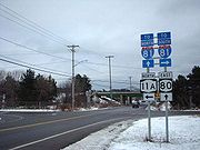
Upon entering Montgomery County, NY 80 becomes signed as a north–south route even though the track of the route is as east–west as it has been since turning northward in Cooperstown. NY 80 heads east to Fort Plain
, a village located on the Mohawk River
(here serving as the path of the Erie Canal
), and becomes Main Street. At Kellogg Street, NY 80 is joined by NY 163
for two blocks to an intersection with NY 5S
(Canal Street) in the heart of the village. Here, NY 163 ends while NY 5S and NY 80 come together on Main Street for a short overlap to Hancock Street, where NY 5S turns southeast and continues toward Canajoharie
. NY 80, however, continues through and out of the village to the northeast on Main, Willett, and River Streets. Once on River, NY 80 passes under the New York State Thruway
(Interstate 90) and crosses the Mohawk River before terminating at NY 5 on the opposite bank in Nelliston
.
and Cooperstown
was originally part of the Second Great Western Turnpike, an early toll road
established in 1801. The road began at the eastern bank of the Chenango River
in Sherburne and proceeded east through Cooperstown to Cherry Valley
, where it connected to the First Great Western Turnpike and, later, the Third Great Western Turnpike. While what is now NY 80 dips south to serve New Berlin
, the turnpike bypassed the settlement to the north, favoring a direct alignment between Columbus
and Edmeston
.
When the first set of posted routes in New York
were assigned in 1924, none of the former turnpike was incorporated into the system; however, a road between Cooperstown and Springfield
along the western edge of Otsego Lake was designated as part of NY 28
. By 1926, a small segment of the ex-Second Great Western Turnpike between Edmeston and West Burlington
was signed as part of NY 44. The NY 80 designation was created in the late 1920s and originally assigned to a previously unnumbered roadway between U.S. Route 20 in Springfield and NY 10A in Indian Lake
via Nelliston
and Speculator
. North of Nelliston, NY 80 followed what is now NY 10
and NY 30
. From Arietta
to Speculator, NY 80 overlapped NY 54 (now NY 8
).
In the 1930 renumbering of state highways in New York, NY 80 was truncated to its current eastern terminus in Nelliston; however, it was also extended southward and westward to NY 173
in Syracuse
, replacing NY 28 from Springfield to Cooperstown and NY 44 from New Berlin to West Burlington. From Sherburne to Columbus and from West Burlington to Cooperstown, NY 80 utilized a previously unnumbered roadway that roughly followed the former alignment of the Second Great Western Turnpike. The remainder of the roadway between Syracuse and Sherburne, and from Columbus to New Berlin, was also previously unnumbered. NY 80 was extended northward to its present terminus at NY 175
by 1932.
The 2.5 miles (4 km) portion of NY 80 between Vincent Corners Road (CR 178) and the Madison County
line was initially maintained by Onondaga County
. On April 1, 1980, ownership and maintenance of this section of the route was transferred from the county to the state of New York
as part of a highway maintenance swap between the two levels of government.
Onondaga County, New York
Onondaga County is a county located in the U.S. state of New York. As of the 2010 census, the population was 467,026. The county seat is Syracuse.Onondaga County is part of the Syracuse, NY Metropolitan Statistical Area....
, Madison
Madison County, New York
Madison County is a county located in the U.S. state of New York. As of the 2010 census, the population was 73,442. It is named after James Madison, fourth President of the United States of America...
, Chenango
Chenango County, New York
Chenango County is a county located in the U.S. state of New York. As of the 2010 census, the population was 50,477. The county's name originates from an Oneida word meaning "large bull-thistle." Its county seat is Norwich.-History:...
, Otsego
Otsego County, New York
Otsego County is a county located in the U.S. state of New York. The 2010 population was 62,259. The county seat is Cooperstown. The name Otsego is from a Mohawk word meaning "place of the rock."-History:...
, Herkimer
Herkimer County, New York
Herkimer County is a county located in the U.S. state of New York. It was created in 1791 north of the Mohawk River out of part of Montgomery County. As of the 2010 census, the population was 64,519. It is named after General Nicholas Herkimer, who died from battle wounds in 1777 after taking part...
, and Montgomery
Montgomery County, New York
As of the census of 2000, there were 49,708 people, 20,038 households, and 13,104 families residing in the county. The population density was 123 people per square mile . There were 22,522 housing units at an average density of 56 per square mile...
Counties in New York
New York
New York is a state in the Northeastern region of the United States. It is the nation's third most populous state. New York is bordered by New Jersey and Pennsylvania to the south, and by Connecticut, Massachusetts and Vermont to the east...
. Its western terminus is located at a junction with NY 175
New York State Route 175
New York State Route 175 is a west–east state highway located in Onondaga County, New York, in the United States. The route begins at an intersection with U.S. Route 20 east of the village of Skaneateles and passes through the village of Marcellus before ending at a junction with...
in the city of Syracuse
Syracuse, New York
Syracuse is a city in and the county seat of Onondaga County, New York, United States, the largest U.S. city with the name "Syracuse", and the fifth most populous city in the state. At the 2010 census, the city population was 145,170, and its metropolitan area had a population of 742,603...
in Onondaga County, from which it actually runs in a north–south direction for 20 miles (32 km). The eastern terminus is located at a junction with NY 5
New York State Route 5
New York State Route 5 is a state highway that extends for across the state of New York in the United States. It begins at the Pennsylvania state line in the Chautauqua County town of Ripley and passes through Buffalo, Syracuse, Utica, Schenectady, and several other smaller cities and...
in the village of Nelliston
Nelliston, New York
Nelliston is a village in Montgomery County, New York, United States. The population was 622 at the 2000 census. The name is from members of the Nellis family.The Village of Nelliston is in the Town of Palatine and is west of Amsterdam....
in Montgomery County. The route is signed north–south within Montgomery County.
Most of NY 80 between Sherburne
Sherburne (village), New York
Sherburne is a village in Chenango County, New York, USA. The population was 1,455 at the 2000 census.The Village of Sherburne is in the Town of Sherburne, north of the City of Norwich.- History :...
and Cooperstown
Cooperstown, New York
Cooperstown is a village in Otsego County, New York, USA. It is located in the Town of Otsego. The population was estimated to be 1,852 at the 2010 census.The Village of Cooperstown is the county seat of Otsego County, New York...
follows the routing of the Second Great Western Turnpike, a 19th century toll road
Toll road
A toll road is a privately or publicly built road for which a driver pays a toll for use. Structures for which tolls are charged include toll bridges and toll tunnels. Non-toll roads are financed using other sources of revenue, most typically fuel tax or general tax funds...
.
Route description
Although NY 80 follows an east–west alignment for most of its routing, two sections, located on its western and easternmost ends, are either signed as north–south (as is the case in Montgomery CountyMontgomery County, New York
As of the census of 2000, there were 49,708 people, 20,038 households, and 13,104 families residing in the county. The population density was 123 people per square mile . There were 22,522 housing units at an average density of 56 per square mile...
) or physically oriented from north to south (such as in central Onondaga County
Onondaga County, New York
Onondaga County is a county located in the U.S. state of New York. As of the 2010 census, the population was 467,026. The county seat is Syracuse.Onondaga County is part of the Syracuse, NY Metropolitan Statistical Area....
).
Central Onondaga County
NY 80 begins at an intersection with NY 175New York State Route 175
New York State Route 175 is a west–east state highway located in Onondaga County, New York, in the United States. The route begins at an intersection with U.S. Route 20 east of the village of Skaneateles and passes through the village of Marcellus before ending at a junction with...
in southern Syracuse
Syracuse, New York
Syracuse is a city in and the county seat of Onondaga County, New York, United States, the largest U.S. city with the name "Syracuse", and the fifth most populous city in the state. At the 2010 census, the city population was 145,170, and its metropolitan area had a population of 742,603...
. The route, named Valley Drive, proceeds south through a largely residential area of Syracuse, following the path of Onondaga Creek
Onondaga Creek
Onondaga Creek is a major tributary of Onondaga Lake which is located in Onondaga County, New York. The headwaters of the creek originate south of the city of Syracuse near the hamlet of Vesper, New York...
through the area. 1 miles (1.6 km) to the south of NY 175 (and 1 miles (1.6 km) west of the interchange between Interstate 81 and Interstate 481), NY 80 intersects NY 173
New York State Route 173
New York State Route 173 is a state highway located in the Syracuse area of central New York, United States. It takes a slightly bow-shaped route from NY 31 in the town of Van Buren to NY 5 in Chittenango, gently curving to the south of Downtown Syracuse in the center of its routing...
(the old path of the Seneca Turnpike) near the southern city limits. Past NY 173, NY 80 parallels U.S. Route 11, I-81, and Onondaga Creek
Onondaga Creek
Onondaga Creek is a major tributary of Onondaga Lake which is located in Onondaga County, New York. The headwaters of the creek originate south of the city of Syracuse near the hamlet of Vesper, New York...
as all four head south out of Syracuse. At the city line, NY 80 becomes South Onondaga Road.
Nedrow, New York
Nedrow is a hamlet located in the Town of Onondaga in Onondaga County, New York. The population was 2,265 at the 2000 census.-Geography:Nedrow is located at , on US Route 11, south of Syracuse, New York...
, south of Syracuse, NY 80 briefly enters the Onondaga Nation Territory
Onondaga Reservation, New York
Onondaga Reservation is an Indian reservation in Onondaga County, New York, United States. It is the territory of the Onondaga Nation. The population was 1,473 at the 2000 census....
, cutting across the northwestern corner of the reservation before turning to follow the western edge of the territory. NY 80 leaves to the southwest shortly after to serve South Onondaga and intersect U.S. Route 20 at Lords Corners. Past US 20, NY 80 continues south to Otisco
Otisco, New York
Otisco is a town in Onondaga County, New York, United States. The population was 2,561 at the 2000 census. The Town of Otisco is in the southwest part of the county. Otisco is situated at the northern edge of the Appalacian Highlands, where an escarpment declines to the Lake Ontario plain and the...
(coming within 3 miles (5 km) of Otisco Lake
Otisco Lake
Otisco Lake is one of the minor Finger Lakes, located at the eastern end of the Finger Lake District, southwest of Syracuse, New York.Otisco Lake is approximately six miles long. The outflow enters first Onondaga Lake via Nine Mile Creek and then Lake Ontario via the Seneca and Oswego Rivers...
), then curves southeast to the Tully
Tully (town), New York
Tully is a town in Onondaga County, New York, USA. The population of the town was 2,709 at the 2000 census. The name of the town is derived from the Roman orator Marcus Tullius Cicero. The town is on the county's south border, south of Syracuse....
hamlet of Vesper before turning fully to the east as it enters the village of Tully
Tully (village), New York
Tully is a village in Onondaga County, New York, USA. The population was 924 at the 2000 census. The name of the village is derived from the Roman orator Marcus Tullius Cicero....
.
Tully to Sherburne
Just west of Tully, NY 80 intersects NY 11ANew York State Route 11A
New York State Route 11A is a state highway in Onondaga County, New York, in the United States. As its numbering implies, NY 11A is a spur of U.S. Route 11. The southern terminus of the route is at an intersection with NY 80 in Tully. Its northern terminus is at a junction...
, US 11, and NY 281
New York State Route 281
New York State Route 281 is a north–south state highway in central New York, United States. It extends for across Cortland and Onondaga Counties. The southern terminus of the route is at an intersection with NY 13 in the town of Cortlandville. Its northern terminus is at a junction with...
on opposite sides of an overpass carrying I-81 over NY 80. Here, all three routes, plus County Route 134 to the southwest, act as frontage roads for I-81 exit 14. US 11 joins NY 80 east of the interchange, following the route into Tully. US 11 heads south at the village center; NY 80, however, continues eastward, overlapping NY 91
New York State Route 91
New York State Route 91 is a north–south state highway in Central New York in the United States. The southern terminus of the route is located at an intersection with NY 13 in the Cortland County town of Truxton. Its northern terminus is located at a junction with NY 173 in...
near Fabius
Fabius (village), New York
Fabius is a village in Onondaga County, New York, United States. The population was 344 at the 2005 census. It is part of the Syracuse Metropolitan Statistical Area.The Village of Fabius is near the center of the Town of Fabius and is south of Syracuse....
and NY 13
New York State Route 13
New York State Route 13 is a state highway that runs mainly north–south for between NY 14 in Horseheads and NY 3 west of Pulaski in Central New York in the United States. In between, NY 13 intersects with Interstate 81 in Cortland and Pulaski and meets the New York...
in western Madison County
Madison County, New York
Madison County is a county located in the U.S. state of New York. As of the 2010 census, the population was 73,442. It is named after James Madison, fourth President of the United States of America...
. Past NY 13, NY 80 continues southeast to Georgetown
Georgetown, New York
Georgetown is a town in Madison County, New York, United States. The population was 946 at the 2000 census.The Town of Georgetown is on the south border of the county.- History :The town was first settled around 1804....
, where it meets NY 26
New York State Route 26
New York State Route 26 is a north–south state highway that runs for through Central New York in the United States. Its southern terminus is located at the Pennsylvania state line south of the town of Vestal in Broome County, where it becomes Pennsylvania Route 267...
. The two routes conjoin and head south into Chenango County
Chenango County, New York
Chenango County is a county located in the U.S. state of New York. As of the 2010 census, the population was 50,477. The county's name originates from an Oneida word meaning "large bull-thistle." Its county seat is Norwich.-History:...
before separating shortly after crossing the county line.
Smyrna (village), New York
Smyrna is a village in Chenango County, New York, USA. The population was 241 at the 2000 census.The Village of Smyrna is located in the Town of Smyrna and is near the north border of Chenango County.-Geography:...
, a small village situated roughly two-thirds of the way between NY 26 and the Otsego County
Otsego County, New York
Otsego County is a county located in the U.S. state of New York. The 2010 population was 62,259. The county seat is Cooperstown. The name Otsego is from a Mohawk word meaning "place of the rock."-History:...
line. East of Smyrna, NY 80 continues northeast, then curves to the southeast as it approaches the Otsego County line, delimited by the Chenango River
Chenango River
The Chenango River is a tributary of the Susquehanna River in central New York in the United States. It drains a dissected plateau area in upstate New York at the northern end of the Susquehanna watershed....
.
Former Second Great Western Turnpike
After crossing over the Chenango River and into Sherburne, NY 80 intersects NY 12New York State Route 12
New York State Route 12 is a state highway extending for through central and northern New York in the United States. The southern terminus of the route is at U.S. Route 11 in the town of Chenango in the Southern Tier. The northern terminus is at NY 37 near the village of...
and begins to follow the old path of the Second Great Western Turnpike across Central New York
Central New York
Central New York is a term used to broadly describe the central region of New York State, roughly including the following counties and cities:...
. The route continues east to Columbus
Columbus, New York
Columbus is a town in Chenango County, New York, United States. The population was 931 at the 2000 census. The town of Columbus is in the northeast corner of the county and is northeast of Norwich.- History :...
, where NY 80 separates from the old routing of the turnpike and heads southeast to intersect NY 8
New York State Route 8
New York State Route 8 is a state highway in the central part of New York in the United States. It runs in a southwest-to-northeast direction from the Southern Tier to the northern part of Lake George. The southern terminus of the route is at an interchange with NY 17 in the town of...
north of New Berlin
New Berlin (village), New York
New Berlin is a village in Chenango County, New York, USA. The population was 1,129 at the 2000 census.The Village of New Berlin is by the east town line of the Town of New Berlin. The village is east of Norwich....
. NY 80 turns south onto NY 8, overlapping the route to New Berlin, where the routes split at the village center. Outside of New Berlin, NY 80 heads northeast to Burlington
Burlington, New York
Burlington is a town in Otsego County, New York, USA. The population was 1,085 at the 2000 census.The Town of Burlington is in the northwest part of the county and is north of Oneonta.-Geography:...
, rejoining the routing of the Second Great Western Turnpike just west of an intersection with NY 51
New York State Route 51
New York State Route 51 is a state highway in the central part of New York state. The highway runs generally in a southwest to northeast direction from the hamlet of Mount Upton to the village of Ilion...
in West Burlington
West Burlington, New York
West Burlington is a hamlet in the western part of the Town of Burlington in Otsego County, New York. It is located at , three miles east of the town of Edmeston on New York State Route 51 and New York State Route 80....
. NY 80 turns north onto NY 51, creating a brief, 1 miles (1.6 km) long concurrency between the two routes. NY 51 and NY 80 split soon after, with NY 51 continuing onward toward Utica
Utica, New York
Utica is a city in and the county seat of Oneida County, New York, United States. The population was 62,235 at the 2010 census, an increase of 2.6% from the 2000 census....
.
NY 80 heads due east from NY 51 to Otsego
Otsego, New York
Otsego is a town in Otsego County, New York, United States. The population was 3,904 at the 2000 census. The town is named after a lake on its border.The Town of Otsego is in the north central part of the county.- History :...
, where it meets NY 205
New York State Route 205
New York State Route 205 is a state highway in New York, running from near the city of Oneonta to the town of Otsego in Otsego County. NY 205 is a two-lane highway its entire length and passes through Hartwick....
. NY 205 joins NY 80 eastward into a small valley surrounding Oaks Creek, where the two routes meet NY 28
New York State Route 28
New York State Route 28 is a state highway extending for in the shape of a "C" between the Hudson Valley city of Kingston and southern Warren County in the U.S. state of New York. Along the way, it intersects several major routes, including Interstate 88 , U.S. Route 20 , and the...
. While NY 205 terminates here, NY 80 joins NY 28, following the route east across the creek and through the hamlet of Fly Creek.
Cooperstown, New York
Cooperstown is a village in Otsego County, New York, USA. It is located in the Town of Otsego. The population was estimated to be 1,852 at the 2010 census.The Village of Cooperstown is the county seat of Otsego County, New York...
at its tip. Shortly after entering Cooperstown, the two routes split as NY 28 turns south at Chestnut Street, following the roadway out of the village toward Oneonta. NY 80, however, turns north onto Chestnut and continues into the heart of the village, where it intersects Main Street, a street lined with shops catering to tourists who visit the nearby National Baseball Hall of Fame. At this intersection, the Second Great Western Turnpike turned east; however, NY 80 continues north on Chestnut for another block before turning onto Lake Street and following the street out of the village.
Cooperstown to Nelliston
Outside of Cooperstown, NY 80 heads north along the western edge of Otsego Lake, passing by both the Fenimore Art MuseumFenimore Art Museum
The Fenimore Art Museum is a museum located in Cooperstown, New York, USA, operating under the auspices of the New York State Historical Association...
and the Farmers' Museum
Farmers' Museum
The Farmers' Museum is located in Cooperstown, New York, and is probably the second-best-known attraction in the town, after the Baseball Hall of Fame and Museum....
just north of Cooperstown. Near the northern tip of the lake in Springfield
Springfield, New York
Springfield is a town in Otsego County, New York, USA. The population was 1,350 at the 2000 census.The Town of Springfield is located at the northern county line of Otsego County and is approximately west of Schenectady.- History :...
, NY 80 intersects US 20 (the former Cherry Valley Turnpike) for the second time. The route continues northward, although the progression becomes more northeasterly as it crosses into the rural southeastern corner of Herkimer County
Herkimer County, New York
Herkimer County is a county located in the U.S. state of New York. It was created in 1791 north of the Mohawk River out of part of Montgomery County. As of the 2010 census, the population was 64,519. It is named after General Nicholas Herkimer, who died from battle wounds in 1777 after taking part...
. NY 80's stay within the county is brief, featuring no points of interest other than an intersection with NY 168
New York State Route 168
New York State Route 168 is an east–west state highway in southern Herkimer County, New York, in the United States. The highway runs for through a largely rural area of Upstate New York, from an intersection with NY 28 in the village of Mohawk to a junction with NY 80 in Stark....
located at the midpoint between where NY 80 traverses the Otsego and Montgomery County
Montgomery County, New York
As of the census of 2000, there were 49,708 people, 20,038 households, and 13,104 families residing in the county. The population density was 123 people per square mile . There were 22,522 housing units at an average density of 56 per square mile...
lines.
Upon entering Montgomery County, NY 80 becomes signed as a north–south route even though the track of the route is as east–west as it has been since turning northward in Cooperstown. NY 80 heads east to Fort Plain
Fort Plain, New York
Fort Plain is a village in Montgomery County, New York, United States. As of the 2000 census, the village population was 2,288. The village is named after a fort built during the American Revolution....
, a village located on the Mohawk River
Mohawk River
The Mohawk River is a river in the U.S. state of New York. It is the largest tributary of the Hudson River. The Mohawk flows into the Hudson in the Capital District, a few miles north of the city of Albany. The river is named for the Mohawk Nation of the Iroquois Confederacy...
(here serving as the path of the Erie Canal
Erie Canal
The Erie Canal is a waterway in New York that runs about from Albany, New York, on the Hudson River to Buffalo, New York, at Lake Erie, completing a navigable water route from the Atlantic Ocean to the Great Lakes. The canal contains 36 locks and encompasses a total elevation differential of...
), and becomes Main Street. At Kellogg Street, NY 80 is joined by NY 163
New York State Route 163
New York State Route 163 is an east–west state highway in Montgomery County, New York, United States. It runs from the village of Fort Plain to the town of Canajoharie in southern Montgomery County. With the exception of its eastern terminus, NY 163 is not signed with directions...
for two blocks to an intersection with NY 5S
New York State Route 5S
New York State Route 5S is an east–west state highway located in the Mohawk Valley of New York in the United States. It extends for from an interchange with NY 5, NY 5A, NY 8, and NY 12 in Utica to a smaller interchange with NY 890 in Rotterdam...
(Canal Street) in the heart of the village. Here, NY 163 ends while NY 5S and NY 80 come together on Main Street for a short overlap to Hancock Street, where NY 5S turns southeast and continues toward Canajoharie
Canajoharie (village), New York
Canajoharie is a village in the town of Canajoharie in Montgomery County, New York, USA. As of the 2000 census, the village had a population of 2,257...
. NY 80, however, continues through and out of the village to the northeast on Main, Willett, and River Streets. Once on River, NY 80 passes under the New York State Thruway
New York State Thruway
The New York State Thruway is a system of limited-access highways located within the state of New York in the United States. The system, known officially as the Governor Thomas E. Dewey Thruway for former New York Governor Thomas E. Dewey, is operated by the New York State Thruway Authority and...
(Interstate 90) and crosses the Mohawk River before terminating at NY 5 on the opposite bank in Nelliston
Nelliston, New York
Nelliston is a village in Montgomery County, New York, United States. The population was 622 at the 2000 census. The name is from members of the Nellis family.The Village of Nelliston is in the Town of Palatine and is west of Amsterdam....
.
History
The routing of most of modern NY 80 between SherburneSherburne (village), New York
Sherburne is a village in Chenango County, New York, USA. The population was 1,455 at the 2000 census.The Village of Sherburne is in the Town of Sherburne, north of the City of Norwich.- History :...
and Cooperstown
Cooperstown, New York
Cooperstown is a village in Otsego County, New York, USA. It is located in the Town of Otsego. The population was estimated to be 1,852 at the 2010 census.The Village of Cooperstown is the county seat of Otsego County, New York...
was originally part of the Second Great Western Turnpike, an early toll road
Toll road
A toll road is a privately or publicly built road for which a driver pays a toll for use. Structures for which tolls are charged include toll bridges and toll tunnels. Non-toll roads are financed using other sources of revenue, most typically fuel tax or general tax funds...
established in 1801. The road began at the eastern bank of the Chenango River
Chenango River
The Chenango River is a tributary of the Susquehanna River in central New York in the United States. It drains a dissected plateau area in upstate New York at the northern end of the Susquehanna watershed....
in Sherburne and proceeded east through Cooperstown to Cherry Valley
Cherry Valley (village), New York
Cherry Valley is a village in Otsego County, New York, United States. The population was 592 at the 2000 census.The Village of Cherry Valley is in the Town of Cherry Valley...
, where it connected to the First Great Western Turnpike and, later, the Third Great Western Turnpike. While what is now NY 80 dips south to serve New Berlin
New Berlin (village), New York
New Berlin is a village in Chenango County, New York, USA. The population was 1,129 at the 2000 census.The Village of New Berlin is by the east town line of the Town of New Berlin. The village is east of Norwich....
, the turnpike bypassed the settlement to the north, favoring a direct alignment between Columbus
Columbus, New York
Columbus is a town in Chenango County, New York, United States. The population was 931 at the 2000 census. The town of Columbus is in the northeast corner of the county and is northeast of Norwich.- History :...
and Edmeston
Edmeston, New York
Edmeston is a town located in Otsego County, New York, United States. As of the 2000 census, the town had a total population of 1,824.The Town of Edmeston is at the western county line. Edmeston is also the name of the largest hamlet in the town...
.
When the first set of posted routes in New York
New York
New York is a state in the Northeastern region of the United States. It is the nation's third most populous state. New York is bordered by New Jersey and Pennsylvania to the south, and by Connecticut, Massachusetts and Vermont to the east...
were assigned in 1924, none of the former turnpike was incorporated into the system; however, a road between Cooperstown and Springfield
Springfield, New York
Springfield is a town in Otsego County, New York, USA. The population was 1,350 at the 2000 census.The Town of Springfield is located at the northern county line of Otsego County and is approximately west of Schenectady.- History :...
along the western edge of Otsego Lake was designated as part of NY 28
New York State Route 28
New York State Route 28 is a state highway extending for in the shape of a "C" between the Hudson Valley city of Kingston and southern Warren County in the U.S. state of New York. Along the way, it intersects several major routes, including Interstate 88 , U.S. Route 20 , and the...
. By 1926, a small segment of the ex-Second Great Western Turnpike between Edmeston and West Burlington
West Burlington, New York
West Burlington is a hamlet in the western part of the Town of Burlington in Otsego County, New York. It is located at , three miles east of the town of Edmeston on New York State Route 51 and New York State Route 80....
was signed as part of NY 44. The NY 80 designation was created in the late 1920s and originally assigned to a previously unnumbered roadway between U.S. Route 20 in Springfield and NY 10A in Indian Lake
Indian Lake, New York
Indian Lake is a town in Hamilton County, New York, United States. The population was 1,471 at the 2000 census. The name is from a large lake partly inside the town.The Town of Indian Lake is on the east border of the county and is northeast of Utica....
via Nelliston
Nelliston, New York
Nelliston is a village in Montgomery County, New York, United States. The population was 622 at the 2000 census. The name is from members of the Nellis family.The Village of Nelliston is in the Town of Palatine and is west of Amsterdam....
and Speculator
Speculator, New York
Speculator is a village in Hamilton County, New York, United States. The population was 348 at the 2000 census. The village is named after a nearby Speculator Mountain....
. North of Nelliston, NY 80 followed what is now NY 10
New York State Route 10
New York State Route 10 is a north–south state highway in the Central New York and North Country regions of New York in the United States. It extends for from the Quickway in Deposit, Delaware County to NY 8 at Higgins Bay, a hamlet in the Hamilton County town of Arietta...
and NY 30
New York State Route 30
New York State Route 30 is a state highway in the central part of New York in the United States. It extends for from an interchange with NY 17 in the Southern Tier to the Canadian border in the state's North Country, where it continues into Quebec as Route 138. On a regional level,...
. From Arietta
Arietta, New York
Arietta is a town in Hamilton County, New York, United States. The population was 293 at the 2000 census. The town was named after the mother of one of the first settlers, Rensselaer Van Rennslaer...
to Speculator, NY 80 overlapped NY 54 (now NY 8
New York State Route 8
New York State Route 8 is a state highway in the central part of New York in the United States. It runs in a southwest-to-northeast direction from the Southern Tier to the northern part of Lake George. The southern terminus of the route is at an interchange with NY 17 in the town of...
).
In the 1930 renumbering of state highways in New York, NY 80 was truncated to its current eastern terminus in Nelliston; however, it was also extended southward and westward to NY 173
New York State Route 173
New York State Route 173 is a state highway located in the Syracuse area of central New York, United States. It takes a slightly bow-shaped route from NY 31 in the town of Van Buren to NY 5 in Chittenango, gently curving to the south of Downtown Syracuse in the center of its routing...
in Syracuse
Syracuse, New York
Syracuse is a city in and the county seat of Onondaga County, New York, United States, the largest U.S. city with the name "Syracuse", and the fifth most populous city in the state. At the 2010 census, the city population was 145,170, and its metropolitan area had a population of 742,603...
, replacing NY 28 from Springfield to Cooperstown and NY 44 from New Berlin to West Burlington. From Sherburne to Columbus and from West Burlington to Cooperstown, NY 80 utilized a previously unnumbered roadway that roughly followed the former alignment of the Second Great Western Turnpike. The remainder of the roadway between Syracuse and Sherburne, and from Columbus to New Berlin, was also previously unnumbered. NY 80 was extended northward to its present terminus at NY 175
New York State Route 175
New York State Route 175 is a west–east state highway located in Onondaga County, New York, in the United States. The route begins at an intersection with U.S. Route 20 east of the village of Skaneateles and passes through the village of Marcellus before ending at a junction with...
by 1932.
The 2.5 miles (4 km) portion of NY 80 between Vincent Corners Road (CR 178) and the Madison County
Madison County, New York
Madison County is a county located in the U.S. state of New York. As of the 2010 census, the population was 73,442. It is named after James Madison, fourth President of the United States of America...
line was initially maintained by Onondaga County
Onondaga County, New York
Onondaga County is a county located in the U.S. state of New York. As of the 2010 census, the population was 467,026. The county seat is Syracuse.Onondaga County is part of the Syracuse, NY Metropolitan Statistical Area....
. On April 1, 1980, ownership and maintenance of this section of the route was transferred from the county to the state of New York
New York
New York is a state in the Northeastern region of the United States. It is the nation's third most populous state. New York is bordered by New Jersey and Pennsylvania to the south, and by Connecticut, Massachusetts and Vermont to the east...
as part of a highway maintenance swap between the two levels of government.