
New York State Route 5S
Encyclopedia
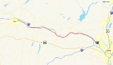
New York State Route 5S (NY 5S) is an east–west state highway
located in the Mohawk Valley
of New York
in the United States. It extends for 73.03 miles (117.53 km) from an interchange with NY 5
, NY 5A
, NY 8
, and NY 12
in Utica
to a smaller interchange with NY 890
in Rotterdam
. The route runs along the south side of the Mohawk River
for its entire length and parallels NY 5, which runs along the north side of the Mohawk River (hence the "S" in the route number of NY 5S). In some locations, NY 5S has been upgraded into a super two
or an expressway
, mostly in Utica and western Herkimer County
. It also runs concurrent with part of New York State Bicycle Route 5 until it reaches NY 103.
When NY 5S was assigned in 1930, the route stretched from Oneida
in the west to Schenectady
in the east. It was later truncated on both ends to eliminate overlaps with other state routes and to accommodate the construction of other roadways, most notably Interstate 890 (I-890) in western Schenectady.
 NY 5S begins at an interchange with I-790
in downtown Utica
, where Oriskany Street changes designations from NY 5A
to NY 5S. At this interchange, I-790 is concurrent
with NY 5
, NY 8
, and NY 12
along Utica's North–South Arterial. The freeway connects NY 5S to the New York State Thruway
. From this interchange, NY 5S travels east across Utica as an urban arterial roadway with at grade intersections. After it crosses Broad Street, it continues east as a limited-access highway with grade-separated intersections to the Herkimer County
line.
The highway meets Culver Avenue as it enters Herkimer County. Not far to the east is an interchange for Turner Street, a small connector road. Route 5S enters West Frankfort and has an exit for Dyke Road, which connects to the Thruway and NY 5
. In West Frankfort, it parallels one of its many old alignments. Route 5S continues southward, encountering Higby Road and Cemetery Street in Frankfort. Just past the Herkimer County Fairgrounds, Route 5S crosses under NY 171
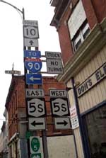
. In East Frankfort, Route 5S intersects with its old routing and turns to the east. Route 5S enters Ilion
, where it meets NY 51
. Route 5S passes to the south of Herkimer
and has junctions with local roads before intersecting NY 28
in Mohawk
. While in Mohawk, Route 5S also intersects with NY 922B, an unsigned reference route.
Past Mohawk, Route 5S begins to parallel the Mohawk River
and the Thruway as it continues eastward towards Rotterdam. Route 5S enters Little Falls and intersects with NY 167
. Route 5S passes through farmlands and parallels the Thruway even farther, passing through the villages of Fort Plain
and Canajoharie
along the way. In the latter, NY 5S is village-maintained in the immediate vicinity of its junction with NY 10
. This 0.19 mile (0.3057746 km) stretch is the only part of the route that is not maintained by the New York State Department of Transportation
(NYSDOT).
Route 5S enters Fultonville
and intersects with NY 30A
. Route 5S begins to make different turns in direction and continues to parallel the Thruway. Route 5S enters Amsterdam
and intersects with NY 30
. Route 5S enters the Rotterdam
area, paralleling Route 5 and the Mohawk River as it begins to head to the south. Route 5S comes to an end at an interchange with NY 890
.
that began in Buffalo
and proceeded eastward across New York
to Albany
. From Utica
to Schenectady
, Route 6 followed the banks of the Mohawk River
through the Mohawk Valley
. Initially, Route 6 used the modern NY 5S corridor from Utica to Mohawk
and from Fultonville
to Amsterdam
. By 1920, the piece of what is now NY 5S from Mohawk to Little Falls
became part of Route 26. On March 1, 1921, Route 26 was truncated to begin in Little Falls while Route 6 was realigned between Fultonville and Amsterdam to use NY 5
instead. When the first set of posted routes in New York
were assigned in 1924, the portion of legislative Route 6 between Utica and Mohawk was designated as the northernmost portion of NY 28
, a north–south route connecting Oneonta to Utica via Springfield
and Richfield Springs
.
In the 1930 renumbering of state highways in New York, NY 28 was rerouted north of Mohawk to follow its modern alignment toward Poland
. Its former routing between Utica and Mohawk became part of NY 5S, an alternate route of NY 5 between Oneida
and Schenectady
. As its suffix implies, NY 5S was mostly a southerly alternate route of NY 5; however, it actually followed a more northerly routing than NY 5 west of Utica. It continued west to Oneida on what is now NY 5A
, NY 69
, NY 365
, and NY 365A and east into Schenectady along Rice and River Roads. NY 5S was truncated eastward to Utica in the early 1940s, placing all of NY 5S south of NY 5 for the first time.
On its eastern end, NY 5S was gradually truncated to its current terminus in Rotterdam
as portions of I-890
was built over the former routing of NY 5S between Rotterdam and Schenectady. The first cutback occurred in the early 1970s following the completion of I-890 between downtown Schenectady and exit 4. The freeway was completed between the New York State Thruway
(I-90
) and Schenectady in the mid-1970s, resulting in the truncation of NY 5S to I-890 exit 2. It was truncated to its current eastern terminus at I-890 (now NY 890
) in the late 1980s after a reconfiguration of the interchange between the Thruway and I-890 resulted in the removal of River Road between I-890 and the current stub end of Rice Road.
From Utica to Mohawk, NY 5S was originally routed on "Old Route 5S" and Main Street. It was realigned in the early 1970s to follow a new freeway between Utica and Ilion
that bypassed Frankfort to the west. A super two
extension of the freeway east to Mohawk was completed sometime after 1982. On April 5, 1987, the bridge carrying the New York State Thruway over Schoharie Creek
collapsed. At the time, the creek was higher and flowing faster than normal due to excessive rains in the area. The segment of NY 5S near Fort Hunter
was reconfigured to carry westbound Thruway traffic while the bridge was rebuilt.
State highway
State highway, state road or state route can refer to one of three related concepts, two of them related to a state or provincial government in a country that is divided into states or provinces :#A...
located in the Mohawk Valley
Mohawk Valley
The Mohawk Valley region of the U.S. state of New York is the area surrounding the Mohawk River, sandwiched between the Adirondack Mountains and Catskill Mountains....
of New York
New York
New York is a state in the Northeastern region of the United States. It is the nation's third most populous state. New York is bordered by New Jersey and Pennsylvania to the south, and by Connecticut, Massachusetts and Vermont to the east...
in the United States. It extends for 73.03 miles (117.53 km) from an interchange with NY 5
New York State Route 5
New York State Route 5 is a state highway that extends for across the state of New York in the United States. It begins at the Pennsylvania state line in the Chautauqua County town of Ripley and passes through Buffalo, Syracuse, Utica, Schenectady, and several other smaller cities and...
, NY 5A
New York State Route 5A
New York State Route 5A is an east–west state highway contained within Oneida County, New York, in the United States. It is a alternate route of NY 5 between New Hartford and downtown Utica. At its eastern end, NY 5A becomes NY 5S. The route is four lanes wide and passes...
, NY 8
New York State Route 8
New York State Route 8 is a state highway in the central part of New York in the United States. It runs in a southwest-to-northeast direction from the Southern Tier to the northern part of Lake George. The southern terminus of the route is at an interchange with NY 17 in the town of...
, and NY 12
New York State Route 12
New York State Route 12 is a state highway extending for through central and northern New York in the United States. The southern terminus of the route is at U.S. Route 11 in the town of Chenango in the Southern Tier. The northern terminus is at NY 37 near the village of...
in Utica
Utica, New York
Utica is a city in and the county seat of Oneida County, New York, United States. The population was 62,235 at the 2010 census, an increase of 2.6% from the 2000 census....
to a smaller interchange with NY 890
New York State Route 890
New York State Route 890 is a long state highway located northwest of downtown Schenectady in the Capital District of New York. Although the route runs north–south, it is signed as east–west to match the posted direction of Interstate 890, of which NY 890 is an...
in Rotterdam
Rotterdam (town), New York
Rotterdam is a town in Schenectady County, New York, United States. The population was 28,316 at the 2000 census.The town of Rotterdam is in the south-central part of the county. It was founded by Dutch settlers, who named it after the port of Rotterdam in the Netherlands, where many emigrants last...
. The route runs along the south side of the Mohawk River
Mohawk River
The Mohawk River is a river in the U.S. state of New York. It is the largest tributary of the Hudson River. The Mohawk flows into the Hudson in the Capital District, a few miles north of the city of Albany. The river is named for the Mohawk Nation of the Iroquois Confederacy...
for its entire length and parallels NY 5, which runs along the north side of the Mohawk River (hence the "S" in the route number of NY 5S). In some locations, NY 5S has been upgraded into a super two
Super two
A super two, super two-lane highway or wide two lane is a two-lane surface road built to high standards, typically including partial control of access, occasional passing lanes and hard shoulders...
or an expressway
Limited-access road
A limited-access road known by various terms worldwide, including limited-access highway, dual-carriageway and expressway, is a highway or arterial road for high-speed traffic which has many or most characteristics of a controlled-access highway , including limited or no access to adjacent...
, mostly in Utica and western Herkimer County
Herkimer County, New York
Herkimer County is a county located in the U.S. state of New York. It was created in 1791 north of the Mohawk River out of part of Montgomery County. As of the 2010 census, the population was 64,519. It is named after General Nicholas Herkimer, who died from battle wounds in 1777 after taking part...
. It also runs concurrent with part of New York State Bicycle Route 5 until it reaches NY 103.
When NY 5S was assigned in 1930, the route stretched from Oneida
Oneida, New York
Oneida is a city in Madison County located west of Oneida Castle and east of Canastota, New York, United States. The population was 10,987 at the 2000 census. The city, like both Oneida County and the nearby silver and china maker, takes its name from the Oneida tribe...
in the west to Schenectady
Schenectady, New York
Schenectady is a city in Schenectady County, New York, United States, of which it is the county seat. As of the 2010 census, the city had a population of 66,135...
in the east. It was later truncated on both ends to eliminate overlaps with other state routes and to accommodate the construction of other roadways, most notably Interstate 890 (I-890) in western Schenectady.
Route description
Interstate 790
Interstate 790 is an auxiliary Interstate Highway in the city of Utica, New York, in the United States. It runs for from an interchange with NY 5A and NY 5S in downtown Utica to exit 31 of the New York State Thruway east of the city...
in downtown Utica
Utica, New York
Utica is a city in and the county seat of Oneida County, New York, United States. The population was 62,235 at the 2010 census, an increase of 2.6% from the 2000 census....
, where Oriskany Street changes designations from NY 5A
New York State Route 5A
New York State Route 5A is an east–west state highway contained within Oneida County, New York, in the United States. It is a alternate route of NY 5 between New Hartford and downtown Utica. At its eastern end, NY 5A becomes NY 5S. The route is four lanes wide and passes...
to NY 5S. At this interchange, I-790 is concurrent
Concurrency (road)
A concurrency, overlap, or coincidence in a road network is an instance of one physical road bearing two or more different highway, motorway, or other route numbers...
with NY 5
New York State Route 5
New York State Route 5 is a state highway that extends for across the state of New York in the United States. It begins at the Pennsylvania state line in the Chautauqua County town of Ripley and passes through Buffalo, Syracuse, Utica, Schenectady, and several other smaller cities and...
, NY 8
New York State Route 8
New York State Route 8 is a state highway in the central part of New York in the United States. It runs in a southwest-to-northeast direction from the Southern Tier to the northern part of Lake George. The southern terminus of the route is at an interchange with NY 17 in the town of...
, and NY 12
New York State Route 12
New York State Route 12 is a state highway extending for through central and northern New York in the United States. The southern terminus of the route is at U.S. Route 11 in the town of Chenango in the Southern Tier. The northern terminus is at NY 37 near the village of...
along Utica's North–South Arterial. The freeway connects NY 5S to the New York State Thruway
New York State Thruway
The New York State Thruway is a system of limited-access highways located within the state of New York in the United States. The system, known officially as the Governor Thomas E. Dewey Thruway for former New York Governor Thomas E. Dewey, is operated by the New York State Thruway Authority and...
. From this interchange, NY 5S travels east across Utica as an urban arterial roadway with at grade intersections. After it crosses Broad Street, it continues east as a limited-access highway with grade-separated intersections to the Herkimer County
Herkimer County, New York
Herkimer County is a county located in the U.S. state of New York. It was created in 1791 north of the Mohawk River out of part of Montgomery County. As of the 2010 census, the population was 64,519. It is named after General Nicholas Herkimer, who died from battle wounds in 1777 after taking part...
line.
The highway meets Culver Avenue as it enters Herkimer County. Not far to the east is an interchange for Turner Street, a small connector road. Route 5S enters West Frankfort and has an exit for Dyke Road, which connects to the Thruway and NY 5
New York State Route 5
New York State Route 5 is a state highway that extends for across the state of New York in the United States. It begins at the Pennsylvania state line in the Chautauqua County town of Ripley and passes through Buffalo, Syracuse, Utica, Schenectady, and several other smaller cities and...
. In West Frankfort, it parallels one of its many old alignments. Route 5S continues southward, encountering Higby Road and Cemetery Street in Frankfort. Just past the Herkimer County Fairgrounds, Route 5S crosses under NY 171
New York State Route 171
New York State Route 171 is an east–west state highway in Herkimer County, New York, in the United States. The route connects the hamlet of Gulph in the town of Frankfort to the village of Frankfort by way of the Frankfort Gorge. Its western terminus is at the junction of County...
. In East Frankfort, Route 5S intersects with its old routing and turns to the east. Route 5S enters Ilion
Ilion, New York
Ilion is a village in Herkimer County, New York, United States. The population was 8,610 at the 2000 census. Ilion is a name for the ancient city of Troy.The Village of Ilion is at the north town line of the Town of German Flatts...
, where it meets NY 51
New York State Route 51
New York State Route 51 is a state highway in the central part of New York state. The highway runs generally in a southwest to northeast direction from the hamlet of Mount Upton to the village of Ilion...
. Route 5S passes to the south of Herkimer
Herkimer (village), New York
Herkimer is a village in Herkimer County, New York, United States, about southeast of Utica. As of the 2000 census, it had a population of 7,498 people. The village is named after the Herkimers, Palatine German immigrants who settled in this area in 1723...
and has junctions with local roads before intersecting NY 28
New York State Route 28
New York State Route 28 is a state highway extending for in the shape of a "C" between the Hudson Valley city of Kingston and southern Warren County in the U.S. state of New York. Along the way, it intersects several major routes, including Interstate 88 , U.S. Route 20 , and the...
in Mohawk
Mohawk, Herkimer County, New York
----Mohawk is a village in Herkimer County, New York, United States. The population was 2,660 at the 2000 census. The village was named after the adjacent river....
. While in Mohawk, Route 5S also intersects with NY 922B, an unsigned reference route.
Past Mohawk, Route 5S begins to parallel the Mohawk River
Mohawk River
The Mohawk River is a river in the U.S. state of New York. It is the largest tributary of the Hudson River. The Mohawk flows into the Hudson in the Capital District, a few miles north of the city of Albany. The river is named for the Mohawk Nation of the Iroquois Confederacy...
and the Thruway as it continues eastward towards Rotterdam. Route 5S enters Little Falls and intersects with NY 167
New York State Route 167
New York State Route 167 is a north–south state highway located mostly within Herkimer County in eastern New York, United States. The southern terminus of the route is at an intersection with U.S. Route 20 in Richfield Springs, Otsego County. Its northern terminus is at a junction with...
. Route 5S passes through farmlands and parallels the Thruway even farther, passing through the villages of Fort Plain
Fort Plain, New York
Fort Plain is a village in Montgomery County, New York, United States. As of the 2000 census, the village population was 2,288. The village is named after a fort built during the American Revolution....
and Canajoharie
Canajoharie (village), New York
Canajoharie is a village in the town of Canajoharie in Montgomery County, New York, USA. As of the 2000 census, the village had a population of 2,257...
along the way. In the latter, NY 5S is village-maintained in the immediate vicinity of its junction with NY 10
New York State Route 10
New York State Route 10 is a north–south state highway in the Central New York and North Country regions of New York in the United States. It extends for from the Quickway in Deposit, Delaware County to NY 8 at Higgins Bay, a hamlet in the Hamilton County town of Arietta...
. This 0.19 mile (0.3057746 km) stretch is the only part of the route that is not maintained by the New York State Department of Transportation
New York State Department of Transportation
The New York State Department of Transportation is responsible for the development and operation of highways, railroads, mass transit systems, ports, waterways and aviation facilities in the U.S...
(NYSDOT).
Route 5S enters Fultonville
Fultonville, New York
Fultonville is a village in Montgomery County, New York, United States. The population was 710 at the 2000 census. The village is named after Robert Fulton, inventor of the steamboat....
and intersects with NY 30A
New York State Route 30A
New York State Route 30A is a state highway in the Capital District of New York in the United States. It serves as a westerly alternate route of NY 30 from near the Schoharie County village of Schoharie to the Fulton County hamlet of Riceville, south of the village of Mayfield...
. Route 5S begins to make different turns in direction and continues to parallel the Thruway. Route 5S enters Amsterdam
Amsterdam (city), New York
Amsterdam is a city located in Montgomery County, New York, USA. As of the 2010 census, the city had a total population of 18,620. The name is derived from the city of Amsterdam in the Netherlands....
and intersects with NY 30
New York State Route 30
New York State Route 30 is a state highway in the central part of New York in the United States. It extends for from an interchange with NY 17 in the Southern Tier to the Canadian border in the state's North Country, where it continues into Quebec as Route 138. On a regional level,...
. Route 5S enters the Rotterdam
Rotterdam (town), New York
Rotterdam is a town in Schenectady County, New York, United States. The population was 28,316 at the 2000 census.The town of Rotterdam is in the south-central part of the county. It was founded by Dutch settlers, who named it after the port of Rotterdam in the Netherlands, where many emigrants last...
area, paralleling Route 5 and the Mohawk River as it begins to head to the south. Route 5S comes to an end at an interchange with NY 890
New York State Route 890
New York State Route 890 is a long state highway located northwest of downtown Schenectady in the Capital District of New York. Although the route runs north–south, it is signed as east–west to match the posted direction of Interstate 890, of which NY 890 is an...
.
History
In 1908, the New York State Legislature created Route 6, an unsigned legislative routeLegislative route
In United States, a legislative route or legislative highway is a highway defined by laws passed in a state legislature. The numbering of such highways may or may not correspond to the numbers familiar to the public as part of the state, U.S. highway, and Interstate highway systems...
that began in Buffalo
Buffalo, New York
Buffalo is the second most populous city in the state of New York, after New York City. Located in Western New York on the eastern shores of Lake Erie and at the head of the Niagara River across from Fort Erie, Ontario, Buffalo is the seat of Erie County and the principal city of the...
and proceeded eastward across New York
New York
New York is a state in the Northeastern region of the United States. It is the nation's third most populous state. New York is bordered by New Jersey and Pennsylvania to the south, and by Connecticut, Massachusetts and Vermont to the east...
to Albany
Albany, New York
Albany is the capital city of the U.S. state of New York, the seat of Albany County, and the central city of New York's Capital District. Roughly north of New York City, Albany sits on the west bank of the Hudson River, about south of its confluence with the Mohawk River...
. From Utica
Utica, New York
Utica is a city in and the county seat of Oneida County, New York, United States. The population was 62,235 at the 2010 census, an increase of 2.6% from the 2000 census....
to Schenectady
Schenectady, New York
Schenectady is a city in Schenectady County, New York, United States, of which it is the county seat. As of the 2010 census, the city had a population of 66,135...
, Route 6 followed the banks of the Mohawk River
Mohawk River
The Mohawk River is a river in the U.S. state of New York. It is the largest tributary of the Hudson River. The Mohawk flows into the Hudson in the Capital District, a few miles north of the city of Albany. The river is named for the Mohawk Nation of the Iroquois Confederacy...
through the Mohawk Valley
Mohawk Valley
The Mohawk Valley region of the U.S. state of New York is the area surrounding the Mohawk River, sandwiched between the Adirondack Mountains and Catskill Mountains....
. Initially, Route 6 used the modern NY 5S corridor from Utica to Mohawk
Mohawk, Herkimer County, New York
----Mohawk is a village in Herkimer County, New York, United States. The population was 2,660 at the 2000 census. The village was named after the adjacent river....
and from Fultonville
Fultonville, New York
Fultonville is a village in Montgomery County, New York, United States. The population was 710 at the 2000 census. The village is named after Robert Fulton, inventor of the steamboat....
to Amsterdam
Amsterdam (city), New York
Amsterdam is a city located in Montgomery County, New York, USA. As of the 2010 census, the city had a total population of 18,620. The name is derived from the city of Amsterdam in the Netherlands....
. By 1920, the piece of what is now NY 5S from Mohawk to Little Falls
Little Falls (town), New York
Little Falls is a town in Herkimer County, New York, United States. The population was 1,544 at the 2000 census. The town is named after a waterfall located nearby.The Town of Little Falls has on its eastern end a small city called Little Falls...
became part of Route 26. On March 1, 1921, Route 26 was truncated to begin in Little Falls while Route 6 was realigned between Fultonville and Amsterdam to use NY 5
New York State Route 5
New York State Route 5 is a state highway that extends for across the state of New York in the United States. It begins at the Pennsylvania state line in the Chautauqua County town of Ripley and passes through Buffalo, Syracuse, Utica, Schenectady, and several other smaller cities and...
instead. When the first set of posted routes in New York
New York
New York is a state in the Northeastern region of the United States. It is the nation's third most populous state. New York is bordered by New Jersey and Pennsylvania to the south, and by Connecticut, Massachusetts and Vermont to the east...
were assigned in 1924, the portion of legislative Route 6 between Utica and Mohawk was designated as the northernmost portion of NY 28
New York State Route 28
New York State Route 28 is a state highway extending for in the shape of a "C" between the Hudson Valley city of Kingston and southern Warren County in the U.S. state of New York. Along the way, it intersects several major routes, including Interstate 88 , U.S. Route 20 , and the...
, a north–south route connecting Oneonta to Utica via Springfield
Springfield, New York
Springfield is a town in Otsego County, New York, USA. The population was 1,350 at the 2000 census.The Town of Springfield is located at the northern county line of Otsego County and is approximately west of Schenectady.- History :...
and Richfield Springs
Richfield Springs, New York
Richfield Springs is a village located in the Town of Richfield, on the north-central border of Otsego County, New York. The population was 1,255 at the 2000 census. The name is derived from some local sulfur springs....
.
In the 1930 renumbering of state highways in New York, NY 28 was rerouted north of Mohawk to follow its modern alignment toward Poland
Poland, Herkimer County, New York
----Poland is a village in Herkimer County, New York, United States. The population was 451 at the 2000 census.The Village of Poland is at the town line shared by the Town of Newport and the Town of Russia. The village is 16 miles north of the county seat in Herkimer and is northeast of Utica...
. Its former routing between Utica and Mohawk became part of NY 5S, an alternate route of NY 5 between Oneida
Oneida, New York
Oneida is a city in Madison County located west of Oneida Castle and east of Canastota, New York, United States. The population was 10,987 at the 2000 census. The city, like both Oneida County and the nearby silver and china maker, takes its name from the Oneida tribe...
and Schenectady
Schenectady, New York
Schenectady is a city in Schenectady County, New York, United States, of which it is the county seat. As of the 2010 census, the city had a population of 66,135...
. As its suffix implies, NY 5S was mostly a southerly alternate route of NY 5; however, it actually followed a more northerly routing than NY 5 west of Utica. It continued west to Oneida on what is now NY 5A
New York State Route 5A
New York State Route 5A is an east–west state highway contained within Oneida County, New York, in the United States. It is a alternate route of NY 5 between New Hartford and downtown Utica. At its eastern end, NY 5A becomes NY 5S. The route is four lanes wide and passes...
, NY 69
New York State Route 69
New York State Route 69 is a state highway extending for across the central portion of the U.S. state of New York. The western terminus of the route is at NY 104 in the Oswego County village of Mexico. The eastern terminus is at NY 5A in the Oneida County village of Yorkville, just...
, NY 365
New York State Route 365
New York State Route 365 is an east–west state highway in the central portion of New York in the United States. It extends for from an intersection with NY 5 east of the Oneida County city of Oneida to a junction with NY 8 in the Herkimer County town of Ohio...
, and NY 365A and east into Schenectady along Rice and River Roads. NY 5S was truncated eastward to Utica in the early 1940s, placing all of NY 5S south of NY 5 for the first time.
On its eastern end, NY 5S was gradually truncated to its current terminus in Rotterdam
Rotterdam (town), New York
Rotterdam is a town in Schenectady County, New York, United States. The population was 28,316 at the 2000 census.The town of Rotterdam is in the south-central part of the county. It was founded by Dutch settlers, who named it after the port of Rotterdam in the Netherlands, where many emigrants last...
as portions of I-890
Interstate 890
Interstate 890 is a long auxiliary Interstate Highway in the vicinity of Schenectady, New York, United States. The highway runs southeast–northwest from an interchange with the New York State Thruway northwest of Schenectady to another junction with the Thruway south of the city and passes...
was built over the former routing of NY 5S between Rotterdam and Schenectady. The first cutback occurred in the early 1970s following the completion of I-890 between downtown Schenectady and exit 4. The freeway was completed between the New York State Thruway
New York State Thruway
The New York State Thruway is a system of limited-access highways located within the state of New York in the United States. The system, known officially as the Governor Thomas E. Dewey Thruway for former New York Governor Thomas E. Dewey, is operated by the New York State Thruway Authority and...
(I-90
Interstate 90 in New York
Interstate 90 is a part of the Interstate Highway System that runs from Seattle, Washington, to Boston, Massachusetts. In the U.S. state of New York, I-90 extends from the Pennsylvania state line at Ripley to the Massachusetts state line at Canaan...
) and Schenectady in the mid-1970s, resulting in the truncation of NY 5S to I-890 exit 2. It was truncated to its current eastern terminus at I-890 (now NY 890
New York State Route 890
New York State Route 890 is a long state highway located northwest of downtown Schenectady in the Capital District of New York. Although the route runs north–south, it is signed as east–west to match the posted direction of Interstate 890, of which NY 890 is an...
) in the late 1980s after a reconfiguration of the interchange between the Thruway and I-890 resulted in the removal of River Road between I-890 and the current stub end of Rice Road.
From Utica to Mohawk, NY 5S was originally routed on "Old Route 5S" and Main Street. It was realigned in the early 1970s to follow a new freeway between Utica and Ilion
Ilion, New York
Ilion is a village in Herkimer County, New York, United States. The population was 8,610 at the 2000 census. Ilion is a name for the ancient city of Troy.The Village of Ilion is at the north town line of the Town of German Flatts...
that bypassed Frankfort to the west. A super two
Super two
A super two, super two-lane highway or wide two lane is a two-lane surface road built to high standards, typically including partial control of access, occasional passing lanes and hard shoulders...
extension of the freeway east to Mohawk was completed sometime after 1982. On April 5, 1987, the bridge carrying the New York State Thruway over Schoharie Creek
Schoharie Creek
Schoharie Creek in New York, USA flows north from the foot of Indian Head Mountain in the Catskill Mountains through the Schoharie Valley to the Mohawk River. It is twice impounded north of Prattsville to create New York City's Schoharie Reservoir and the Blenheim-Gilboa Power Project.Two notable...
collapsed. At the time, the creek was higher and flowing faster than normal due to excessive rains in the area. The segment of NY 5S near Fort Hunter
Fort Hunter, New York
Fort Hunter is a hamlet in the town of Florida in Montgomery County, New York, on the Mohawk River at Schoharie Creek.In the 18th century, Fort Hunter was built as a fort near the location of one of the two primary Mohawk settlements. The Mohawk name for the village was rendered variously in...
was reconfigured to carry westbound Thruway traffic while the bridge was rebuilt.