

New York State Route 5A
Encyclopedia
New York State Route 5A (NY 5A) is an east–west state highway
contained within Oneida County, New York
, in the United States. It is a 5.65 miles (9.1 km) alternate route
of NY 5
between New Hartford
and downtown Utica
. At its eastern end, NY 5A becomes NY 5S
. The route is four lanes wide and passes through mostly commercial areas. It was assigned to its current alignment in the mid-1930s.
 NY 5A begins at an intersection with NY 5
in New Hartford
only 120 yards (109.7 m) from the eastern terminus of NY 5B. The route heads northeast as the predominantly four-lane wide Commercial Drive, passing the Sangertown Square
shopping mall and paralleling Mud Creek as it progresses through New Hartford. Near the southwestern extent of New York Mills
, NY 5A meets NY 840
by way of a single-point urban interchange
.
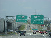
Past NY 840, NY 5A straddles the western village line of New York Mills as it crosses over and parallels Sauquoit Creek to a trumpet interchange with NY 69
(Oriskany Boulevard) in the adjacent village of Yorkville
. NY 69 ends here; however, NY 5S joins the four-lane Oriskany Boulevard eastward through Yorkville into Utica
. Within the Utica city limits, NY 5A closely parallels the CSX Transportation
-owned Mohawk Subdivision as it heads along the northern fringe of the city. After crossing the New York, Susquehanna and Western Railroad, NY 5A meets the North–South Arterial (Interstate 790, NY 5, NY 8
, and NY 12
) by way of an interchange. NY 5A becomes NY 5S
at the midpoint of the interchange.
extending from Maple View to Utica
via Rome
and Whitesboro
. Route 28 followed the north bank of the Mohawk River
from Rome to Marcy
, where it turned south toward Whitesboro on modern NY 291
. Once on the south bank, the route proceeded to Utica on Main and Whitesboro Streets. When the first set of posted routes in New York
were assigned in 1924, all of legislative Route 28 was designated as part of NY 11. Within Utica, NY 11 followed Whitesboro and Court Streets east to Genesee Street, where it ended at NY 5
and NY 12
. NY 11 was renumbered to NY 76 in 1927 to eliminate numerical duplication with the new U.S. Route 11
.
The NY 76 designation was reassigned elsewhere in the state as part of the 1930 renumbering of state highways in New York. From Whitesboro to downtown Utica, NY 76's former alignment was co-designated as part of NY 5S
and NY 12C. In the mid-1930s, a north–south connector between NY 5 in New Hartford
and NY 5S and NY 12C in Yorkville
was designated as NY 5A. NY 5S and NY 12C were realigned in the late 1930s to follow a new highway named Oriskany Boulevard through Whitesboro and Yorkville. In the early 1940s, NY 5S was truncated to begin in Utica while its former alignment between Rome and Utica became part of NY 69
.
By 1947, NY 12C and NY 69 were realigned to follow Oriskany Street through western Utica while NY 5A was extended eastward along Oriskany Street to a new terminus in downtown Utica, creating overlaps with both NY 12C and NY 69. The overlaps remained in place until January 1, 1970, when NY 12C was eliminated and NY 69 was truncated to end in Yorkville. The intersection between Commercial Drive and Oriskany Boulevard was converted into a trumpet interchange around the same time.
State highway
State highway, state road or state route can refer to one of three related concepts, two of them related to a state or provincial government in a country that is divided into states or provinces :#A...
contained within Oneida County, New York
Oneida County, New York
Oneida County is a county located in the U.S. state of New York. As of the 2010 census, the population was 234,878. The county seat is Utica. The name is in honor of the Oneida, an Iroquoian tribe that formerly occupied the region....
, in the United States. It is a 5.65 miles (9.1 km) alternate route
Alternate route
An official alternate route is a special route in the United States that provides an alternate alignment for a highway. They are loop roads and found in many road systems in the United States including the U.S. Route system and various state route systems...
of NY 5
New York State Route 5
New York State Route 5 is a state highway that extends for across the state of New York in the United States. It begins at the Pennsylvania state line in the Chautauqua County town of Ripley and passes through Buffalo, Syracuse, Utica, Schenectady, and several other smaller cities and...
between New Hartford
New Hartford (town), New York
.New Hartford is a town in Oneida County, New York, United States. As of the 2000 census, the town population was 21,172. The name of New Hartford was provided by a settler family from Hartford, Connecticut....
and downtown Utica
Utica, New York
Utica is a city in and the county seat of Oneida County, New York, United States. The population was 62,235 at the 2010 census, an increase of 2.6% from the 2000 census....
. At its eastern end, NY 5A becomes NY 5S
New York State Route 5S
New York State Route 5S is an east–west state highway located in the Mohawk Valley of New York in the United States. It extends for from an interchange with NY 5, NY 5A, NY 8, and NY 12 in Utica to a smaller interchange with NY 890 in Rotterdam...
. The route is four lanes wide and passes through mostly commercial areas. It was assigned to its current alignment in the mid-1930s.
Route description
New York State Route 5
New York State Route 5 is a state highway that extends for across the state of New York in the United States. It begins at the Pennsylvania state line in the Chautauqua County town of Ripley and passes through Buffalo, Syracuse, Utica, Schenectady, and several other smaller cities and...
in New Hartford
New Hartford (town), New York
.New Hartford is a town in Oneida County, New York, United States. As of the 2000 census, the town population was 21,172. The name of New Hartford was provided by a settler family from Hartford, Connecticut....
only 120 yards (109.7 m) from the eastern terminus of NY 5B. The route heads northeast as the predominantly four-lane wide Commercial Drive, passing the Sangertown Square
Sangertown Square
Sangertown Square is regional shopping mall located in New Hartford, New York off Rts. 5 and 5A near Utica, New York. The mall was built in 1980 and has about 70 stores and a central food court...
shopping mall and paralleling Mud Creek as it progresses through New Hartford. Near the southwestern extent of New York Mills
New York Mills, New York
New York Mills is a village in Oneida County, New York, USA. The population was 3,327 at the 2010 census.The Village of New York Mills is partly in the Town of Whitestown and partly in the Town of New Hartford. It is a western suburb of the City of Utica.-History:There were three mills which gave...
, NY 5A meets NY 840
New York State Route 840
New York State Route 840 is an east–west state highway in Oneida County, New York, United States. It is a superhighway extension of Judd Road , which ended at Halsey Road in Whitestown prior to the construction of NY 840...
by way of a single-point urban interchange
Single-point urban interchange
A single-point urban interchange , also called a single-point interchange or single-point diamond interchange , is a type of highway interchange...
.
Past NY 840, NY 5A straddles the western village line of New York Mills as it crosses over and parallels Sauquoit Creek to a trumpet interchange with NY 69
New York State Route 69
New York State Route 69 is a state highway extending for across the central portion of the U.S. state of New York. The western terminus of the route is at NY 104 in the Oswego County village of Mexico. The eastern terminus is at NY 5A in the Oneida County village of Yorkville, just...
(Oriskany Boulevard) in the adjacent village of Yorkville
Yorkville, Oneida County, New York
Yorkville is a village in Oneida County, New York, USA. The population was 2,675 at the 2000 census.The Village of Yorkville is in the southeast part of the Town of Whitestown adjacent to the City of Utica.- History :...
. NY 69 ends here; however, NY 5S joins the four-lane Oriskany Boulevard eastward through Yorkville into Utica
Utica, New York
Utica is a city in and the county seat of Oneida County, New York, United States. The population was 62,235 at the 2010 census, an increase of 2.6% from the 2000 census....
. Within the Utica city limits, NY 5A closely parallels the CSX Transportation
CSX Transportation
CSX Transportation operates a Class I railroad in the United States known as the CSX Railroad. It is the main subsidiary of the CSX Corporation. The company is headquartered in Jacksonville, Florida, and owns approximately 21,000 route miles...
-owned Mohawk Subdivision as it heads along the northern fringe of the city. After crossing the New York, Susquehanna and Western Railroad, NY 5A meets the North–South Arterial (Interstate 790, NY 5, NY 8
New York State Route 8
New York State Route 8 is a state highway in the central part of New York in the United States. It runs in a southwest-to-northeast direction from the Southern Tier to the northern part of Lake George. The southern terminus of the route is at an interchange with NY 17 in the town of...
, and NY 12
New York State Route 12
New York State Route 12 is a state highway extending for through central and northern New York in the United States. The southern terminus of the route is at U.S. Route 11 in the town of Chenango in the Southern Tier. The northern terminus is at NY 37 near the village of...
) by way of an interchange. NY 5A becomes NY 5S
New York State Route 5S
New York State Route 5S is an east–west state highway located in the Mohawk Valley of New York in the United States. It extends for from an interchange with NY 5, NY 5A, NY 8, and NY 12 in Utica to a smaller interchange with NY 890 in Rotterdam...
at the midpoint of the interchange.
History
In 1908, the New York State Legislature created Route 28, an unsigned legislative routeLegislative route
In United States, a legislative route or legislative highway is a highway defined by laws passed in a state legislature. The numbering of such highways may or may not correspond to the numbers familiar to the public as part of the state, U.S. highway, and Interstate highway systems...
extending from Maple View to Utica
Utica, New York
Utica is a city in and the county seat of Oneida County, New York, United States. The population was 62,235 at the 2010 census, an increase of 2.6% from the 2000 census....
via Rome
Rome, New York
Rome is a city in Oneida County, New York, United States. It is located in north-central or "upstate" New York. The population was 44,797 at the 2010 census. It is in New York's 24th congressional district. In 1758, British forces began construction of Fort Stanwix at this strategic location, but...
and Whitesboro
Whitesboro, New York
Whitesboro is a village in Oneida County, New York, United States. United States. The population was 3,943 at the 2000 census. The village is named after Hugh White, an early settler.The Village of Whitesboro is inside the Town of Whitestown....
. Route 28 followed the north bank of the Mohawk River
Mohawk River
The Mohawk River is a river in the U.S. state of New York. It is the largest tributary of the Hudson River. The Mohawk flows into the Hudson in the Capital District, a few miles north of the city of Albany. The river is named for the Mohawk Nation of the Iroquois Confederacy...
from Rome to Marcy
Marcy, New York
Marcy is a town in Oneida County, New York, United States. The population was 9,469 at the 2000 census. The town was named after Governor William L. Marcy....
, where it turned south toward Whitesboro on modern NY 291
New York State Route 291
New York State Route 291 is a state highway in Oneida County, New York, in the United States. The route extends from an intersection with NY 69 in the town of Whitestown to a junction with NY 365 in the extreme northern tip of the town of Marcy, near the hamlet of Stittville. It is...
. Once on the south bank, the route proceeded to Utica on Main and Whitesboro Streets. When the first set of posted routes in New York
New York
New York is a state in the Northeastern region of the United States. It is the nation's third most populous state. New York is bordered by New Jersey and Pennsylvania to the south, and by Connecticut, Massachusetts and Vermont to the east...
were assigned in 1924, all of legislative Route 28 was designated as part of NY 11. Within Utica, NY 11 followed Whitesboro and Court Streets east to Genesee Street, where it ended at NY 5
New York State Route 5
New York State Route 5 is a state highway that extends for across the state of New York in the United States. It begins at the Pennsylvania state line in the Chautauqua County town of Ripley and passes through Buffalo, Syracuse, Utica, Schenectady, and several other smaller cities and...
and NY 12
New York State Route 12
New York State Route 12 is a state highway extending for through central and northern New York in the United States. The southern terminus of the route is at U.S. Route 11 in the town of Chenango in the Southern Tier. The northern terminus is at NY 37 near the village of...
. NY 11 was renumbered to NY 76 in 1927 to eliminate numerical duplication with the new U.S. Route 11
U.S. Route 11 in New York
U.S. Route 11 is a part of the U.S. Highway System that runs from New Orleans, Louisiana, to the Canadian border at Rouses Point, New York...
.
The NY 76 designation was reassigned elsewhere in the state as part of the 1930 renumbering of state highways in New York. From Whitesboro to downtown Utica, NY 76's former alignment was co-designated as part of NY 5S
New York State Route 5S
New York State Route 5S is an east–west state highway located in the Mohawk Valley of New York in the United States. It extends for from an interchange with NY 5, NY 5A, NY 8, and NY 12 in Utica to a smaller interchange with NY 890 in Rotterdam...
and NY 12C. In the mid-1930s, a north–south connector between NY 5 in New Hartford
New Hartford (town), New York
.New Hartford is a town in Oneida County, New York, United States. As of the 2000 census, the town population was 21,172. The name of New Hartford was provided by a settler family from Hartford, Connecticut....
and NY 5S and NY 12C in Yorkville
Yorkville, Oneida County, New York
Yorkville is a village in Oneida County, New York, USA. The population was 2,675 at the 2000 census.The Village of Yorkville is in the southeast part of the Town of Whitestown adjacent to the City of Utica.- History :...
was designated as NY 5A. NY 5S and NY 12C were realigned in the late 1930s to follow a new highway named Oriskany Boulevard through Whitesboro and Yorkville. In the early 1940s, NY 5S was truncated to begin in Utica while its former alignment between Rome and Utica became part of NY 69
New York State Route 69
New York State Route 69 is a state highway extending for across the central portion of the U.S. state of New York. The western terminus of the route is at NY 104 in the Oswego County village of Mexico. The eastern terminus is at NY 5A in the Oneida County village of Yorkville, just...
.
By 1947, NY 12C and NY 69 were realigned to follow Oriskany Street through western Utica while NY 5A was extended eastward along Oriskany Street to a new terminus in downtown Utica, creating overlaps with both NY 12C and NY 69. The overlaps remained in place until January 1, 1970, when NY 12C was eliminated and NY 69 was truncated to end in Yorkville. The intersection between Commercial Drive and Oriskany Boulevard was converted into a trumpet interchange around the same time.