
New York State Route 840
Encyclopedia
New York State Route 840 (NY 840) is an east–west state highway
in Oneida County, New York
, United States
. It is a superhighway extension of Judd Road (County Route 840), which ended at Halsey Road in Whitestown
prior to the construction of NY 840. The western terminus of NY 840 is at the junction of Judd and Halsey Roads while the eastern terminus is at NY 5
, NY 8
, and NY 12
near the southern city line of Utica
.
NY 840 first opened to traffic in 2005. It was ceremoniously designated as the Officer Joseph D. Corr Memorial Highway in 2007. In 2008, part of Judd Road was redesignated as County Route 840 to match the designation of the state highway it connected to.
. North of this junction, NY 840 continues as Judd Road, designated as County Route 840. NY 840 initially heads south as a four-lane undivided highway through a rural portion of Oneida County
to a junction with Clark Mills Road, then turns southeast to parallel a set of high-voltage power lines through the town. Upon crossing into the town of New Hartford
, NY 840 becomes a limited-access highway and turns to follow a more easterly routing.
 As NY 840 approaches the residential outskirts of Utica
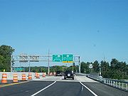
, it connects to Middle Settlement Road by way of a Partial cloverleaf interchange. East of the junction, NY 840 curves southeastward and enters a major commercial district, where it intersects NY 5A
by way of a single-point urban interchange
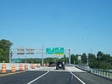
. The district is confined mostly to the vicinity of NY 5A, however, and NY 840 proceeds southeast through residential neighborhoods and around pockets of commercial development to a cloverleaf interchange
with the North–South Arterial (NY 5
, NY 8
, and NY 12
) near the southern city line of Utica
. NY 840 ends here; however, the highway continues southeast through the interchange as NY 8.
Although NY 840 is signed as an east–west route, the reference marker
s along NY 840 are sequenced from the arterial concurrency northward, ending at the Halsey Road intersection, in violation of standard New York State Department of Transportation
(NYSDOT) practice. NYSDOT also lists the mileposts along the route from east to west in its annual Traffic Volume Report, implying a north–south orientation; however, NY 840 is listed as an east–west route in the NYSDOT route log, listing its "beginning" terminus at CR 40 (Judd Road, now CR 840).
that would ceremoniously designate NY 840 as the "Officer Joseph D. Corr Memorial Highway". It was passed by both houses of the New York State Legislature and signed into law by Governor Eliot Spitzer
on July 18, 2007.
NY 840 is commonly known as Judd Road Extension in reference to Judd Road, the county-maintained road it connects to at its western end. Judd Road and Coleman Mills Road, the continuation of Judd Road north of the former Oneida County Airport
, were initially designated as County Route 40. Meanwhile, Sutliff Road, a road branching off of Coleman Mills Road near the airport, was originally County Route 90. In September 2008, legislation was introduced in Oneida County
that would redesignate the portion of Judd and Coleman Mills Roads from Halsey Road to Sutliff Road and all of Sutliff Road as County Route 840. The changes were proposed in an effort to bring the highways, which connect NY 840 to NY 233
, under one designation that would serve as a clear continuation of NY 840 through northwest Whitestown. The redesignation was approved by the county legislature on September 24, 2008.
|rowspan=3|Whitestown
|rowspan=2|0.00
|
|Continuation beyond Halsey Road
|-
| via Halsey Road
|At-grade intersection; Thruway access via Halsey Road west to Westmoreland (exit 32)
|-
|0.50
|Clark Mills Road
|At-grade intersection
|-
|New Hartford
|2.35
|Middle Settlement Road
|Parclo interchange
|-
|rowspan=3|Utica
|2.88
|
|Single-point urban interchange
|-
|rowspan=2|4.02
|
|Cloverleaf interchange
|-
|
|Continuation beyond NY 5 / NY 12
State highway
State highway, state road or state route can refer to one of three related concepts, two of them related to a state or provincial government in a country that is divided into states or provinces :#A...
in Oneida County, New York
Oneida County, New York
Oneida County is a county located in the U.S. state of New York. As of the 2010 census, the population was 234,878. The county seat is Utica. The name is in honor of the Oneida, an Iroquoian tribe that formerly occupied the region....
, United States
United States
The United States of America is a federal constitutional republic comprising fifty states and a federal district...
. It is a superhighway extension of Judd Road (County Route 840), which ended at Halsey Road in Whitestown
Whitestown, New York
Whitestown is a town in Oneida County, New York, USA. The population was 18,635 at the 2000 census. The name is derived from Judge Hugh White, an early settler.The Town of Whitestown is immediately west of Utica, New York...
prior to the construction of NY 840. The western terminus of NY 840 is at the junction of Judd and Halsey Roads while the eastern terminus is at NY 5
New York State Route 5
New York State Route 5 is a state highway that extends for across the state of New York in the United States. It begins at the Pennsylvania state line in the Chautauqua County town of Ripley and passes through Buffalo, Syracuse, Utica, Schenectady, and several other smaller cities and...
, NY 8
New York State Route 8
New York State Route 8 is a state highway in the central part of New York in the United States. It runs in a southwest-to-northeast direction from the Southern Tier to the northern part of Lake George. The southern terminus of the route is at an interchange with NY 17 in the town of...
, and NY 12
New York State Route 12
New York State Route 12 is a state highway extending for through central and northern New York in the United States. The southern terminus of the route is at U.S. Route 11 in the town of Chenango in the Southern Tier. The northern terminus is at NY 37 near the village of...
near the southern city line of Utica
Utica, New York
Utica is a city in and the county seat of Oneida County, New York, United States. The population was 62,235 at the 2010 census, an increase of 2.6% from the 2000 census....
.
NY 840 first opened to traffic in 2005. It was ceremoniously designated as the Officer Joseph D. Corr Memorial Highway in 2007. In 2008, part of Judd Road was redesignated as County Route 840 to match the designation of the state highway it connected to.
Route description
NY 840 begins at an intersection with Halsey Road and Judd Road in the town of WhitestownWhitestown, New York
Whitestown is a town in Oneida County, New York, USA. The population was 18,635 at the 2000 census. The name is derived from Judge Hugh White, an early settler.The Town of Whitestown is immediately west of Utica, New York...
. North of this junction, NY 840 continues as Judd Road, designated as County Route 840. NY 840 initially heads south as a four-lane undivided highway through a rural portion of Oneida County
Oneida County, New York
Oneida County is a county located in the U.S. state of New York. As of the 2010 census, the population was 234,878. The county seat is Utica. The name is in honor of the Oneida, an Iroquoian tribe that formerly occupied the region....
to a junction with Clark Mills Road, then turns southeast to parallel a set of high-voltage power lines through the town. Upon crossing into the town of New Hartford
New Hartford (town), New York
.New Hartford is a town in Oneida County, New York, United States. As of the 2000 census, the town population was 21,172. The name of New Hartford was provided by a settler family from Hartford, Connecticut....
, NY 840 becomes a limited-access highway and turns to follow a more easterly routing.
Utica, New York
Utica is a city in and the county seat of Oneida County, New York, United States. The population was 62,235 at the 2010 census, an increase of 2.6% from the 2000 census....
, it connects to Middle Settlement Road by way of a Partial cloverleaf interchange. East of the junction, NY 840 curves southeastward and enters a major commercial district, where it intersects NY 5A
New York State Route 5A
New York State Route 5A is an east–west state highway contained within Oneida County, New York, in the United States. It is a alternate route of NY 5 between New Hartford and downtown Utica. At its eastern end, NY 5A becomes NY 5S. The route is four lanes wide and passes...
by way of a single-point urban interchange
Single-point urban interchange
A single-point urban interchange , also called a single-point interchange or single-point diamond interchange , is a type of highway interchange...
. The district is confined mostly to the vicinity of NY 5A, however, and NY 840 proceeds southeast through residential neighborhoods and around pockets of commercial development to a cloverleaf interchange
Cloverleaf interchange
A cloverleaf interchange is a two-level interchange in which left turns, reverse direction in left-driving regions, are handled by ramp roads...
with the North–South Arterial (NY 5
New York State Route 5
New York State Route 5 is a state highway that extends for across the state of New York in the United States. It begins at the Pennsylvania state line in the Chautauqua County town of Ripley and passes through Buffalo, Syracuse, Utica, Schenectady, and several other smaller cities and...
, NY 8
New York State Route 8
New York State Route 8 is a state highway in the central part of New York in the United States. It runs in a southwest-to-northeast direction from the Southern Tier to the northern part of Lake George. The southern terminus of the route is at an interchange with NY 17 in the town of...
, and NY 12
New York State Route 12
New York State Route 12 is a state highway extending for through central and northern New York in the United States. The southern terminus of the route is at U.S. Route 11 in the town of Chenango in the Southern Tier. The northern terminus is at NY 37 near the village of...
) near the southern city line of Utica
Utica, New York
Utica is a city in and the county seat of Oneida County, New York, United States. The population was 62,235 at the 2010 census, an increase of 2.6% from the 2000 census....
. NY 840 ends here; however, the highway continues southeast through the interchange as NY 8.
Although NY 840 is signed as an east–west route, the reference marker
Reference marker (New York)
In New York, a reference marker is a small green sign mounted approximately every one-tenth mile on highways maintained by the New York State Department of Transportation. This was initiated in response to the Highway Safety Act of 1966 enacted by Congress, in an effort to monitor traffic and...
s along NY 840 are sequenced from the arterial concurrency northward, ending at the Halsey Road intersection, in violation of standard New York State Department of Transportation
New York State Department of Transportation
The New York State Department of Transportation is responsible for the development and operation of highways, railroads, mass transit systems, ports, waterways and aviation facilities in the U.S...
(NYSDOT) practice. NYSDOT also lists the mileposts along the route from east to west in its annual Traffic Volume Report, implying a north–south orientation; however, NY 840 is listed as an east–west route in the NYSDOT route log, listing its "beginning" terminus at CR 40 (Judd Road, now CR 840).
History
The first section of NY 840 opened to traffic in June 2005. The entirety of the highway opened on October 3, 2005. In April 2007, a bill was introduced in the New York State SenateNew York State Senate
The New York State Senate is one of two houses in the New York State Legislature and has members each elected to two-year terms. There are no limits on the number of terms one may serve...
that would ceremoniously designate NY 840 as the "Officer Joseph D. Corr Memorial Highway". It was passed by both houses of the New York State Legislature and signed into law by Governor Eliot Spitzer
Eliot Spitzer
Eliot Laurence Spitzer is an American lawyer, former Democratic Party politician, and political commentator. He was the co-host of In the Arena, a talk-show and punditry forum broadcast on CNN until CNN cancelled his show in July of 2011...
on July 18, 2007.
NY 840 is commonly known as Judd Road Extension in reference to Judd Road, the county-maintained road it connects to at its western end. Judd Road and Coleman Mills Road, the continuation of Judd Road north of the former Oneida County Airport
Oneida County Airport
Oneida County Airport was a public airport located inthe Town of Whitestown in Oneida County, New York, six miles northwest of the central business district of Utica...
, were initially designated as County Route 40. Meanwhile, Sutliff Road, a road branching off of Coleman Mills Road near the airport, was originally County Route 90. In September 2008, legislation was introduced in Oneida County
Oneida County, New York
Oneida County is a county located in the U.S. state of New York. As of the 2010 census, the population was 234,878. The county seat is Utica. The name is in honor of the Oneida, an Iroquoian tribe that formerly occupied the region....
that would redesignate the portion of Judd and Coleman Mills Roads from Halsey Road to Sutliff Road and all of Sutliff Road as County Route 840. The changes were proposed in an effort to bring the highways, which connect NY 840 to NY 233
New York State Route 233
New York State Route 233 is a state highway in Oneida County, New York, United States. The southern terminus of the route is at an intersection with NY 12B southwest of the Clinton. Its northern terminus is at an interchange with the Utica–Rome Expressway within the Rome city limits but...
, under one designation that would serve as a clear continuation of NY 840 through northwest Whitestown. The redesignation was approved by the county legislature on September 24, 2008.
Exit list
|-|rowspan=3|Whitestown
Whitestown, New York
Whitestown is a town in Oneida County, New York, USA. The population was 18,635 at the 2000 census. The name is derived from Judge Hugh White, an early settler.The Town of Whitestown is immediately west of Utica, New York...
|rowspan=2|0.00
|
|Continuation beyond Halsey Road
|-
| via Halsey Road
|At-grade intersection; Thruway access via Halsey Road west to Westmoreland (exit 32)
|-
|0.50
|Clark Mills Road
|At-grade intersection
|-
|New Hartford
New Hartford (town), New York
.New Hartford is a town in Oneida County, New York, United States. As of the 2000 census, the town population was 21,172. The name of New Hartford was provided by a settler family from Hartford, Connecticut....
|2.35
|Middle Settlement Road
|Parclo interchange
Parclo interchange
A partial cloverleaf interchange or parclo is a modification of a cloverleaf interchange. The parclo interchange was developed by the Ontario Ministry of Transportation as a replacement for the cloverleaf on 400-Series Highways, removing the dangerous weaving patterns and allowing for more...
|-
|rowspan=3|Utica
Utica, New York
Utica is a city in and the county seat of Oneida County, New York, United States. The population was 62,235 at the 2010 census, an increase of 2.6% from the 2000 census....
|2.88
|
|Single-point urban interchange
Single-point urban interchange
A single-point urban interchange , also called a single-point interchange or single-point diamond interchange , is a type of highway interchange...
|-
|rowspan=2|4.02
|
|Cloverleaf interchange
Cloverleaf interchange
A cloverleaf interchange is a two-level interchange in which left turns, reverse direction in left-driving regions, are handled by ramp roads...
|-
|
|Continuation beyond NY 5 / NY 12