
Vermont Route 17
Encyclopedia
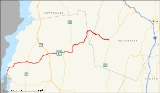
Vermont Route 17 is a 40.409 miles (65.032 km) long state highway
in western Vermont
, United States
. The temporary western terminus is at the Lake Champlain
shoreline in Addison
just west of its junction with VT 125
. The eastern terminus is at VT 100
in Waitsfield
. VT 17 was initially much shorter than it is today, extending from the Champlain Bridge
to Addison upon assignment. It was extended in the late 1960s through the Green Mountains
to Waitsfield.
town center. West of Bristol, the route passes through generally level terrain and connects multiple communities. East of Bristol, VT 17 is more mountainous and more rural in nature.
shoreline at the former site of the Champlain Bridge
in Addison
, Addison County
. The route heads northeastward, intersecting VT 125
adjacent to the Chimney Point State Historical Site at Chimney Point
. It continues northward along the lakeshore for roughly 2 miles (3 km) (passing D.A.R. State Park) before turning eastward toward Addison
.
 In the center of Addison, situated 6 miles (10 km) from Lake Champlain, VT 17 intersects VT 22A
. VT 17 continues east from Addison, crossing over the Otter Creek and intersecting VT 23
near Weybridge
prior to curving to the northeast toward Waltham
. Midway between Waltham and New Haven
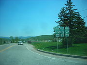
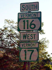
, VT 17 briefly overlaps U.S. Route 7, then continues eastward through New Haven to Bristol
. Prior to entering the town center, VT 17 intersects VT 116
. VT 116 turns east onto VT 17, joining the route through Bristol along Main Street.
. The roadway and waterway head east, following a winding route through the Green Mountains
. When New Haven splits off to the southeast shortly afterward, VT 17 and VT 116 continue north along Baldwin Creek up to the point where VT 17 and VT 116 diverge. While VT 116 continues north along Beaver Brook, VT 17 remains in the vicinity of Baldwin Creek as it heads northeast through the Green Mountains.
 Midway between Bristol and Waitsfield
, VT 17 intersects Gore Road, a local road that leads to eastern Burlington
15 miles (24 km) to the north. The route crosses into Chittenden County
, as well as the Camel's Hump State Park, shortly afterward. The route leaves Chittenden County and passes into Washington County
2 miles (3 km) later upon traversing the Appalachian Gap
, a mountain pass located to the north of Mount Ellen. East of the gap, VT 17 continues through the eastern Green Mountains for 6 miles (10 km) to Waitsfield, where it terminates at VT 100
.
 The road connecting the ferry landing at Chimney Point
to the town center of Addison
was designated as VT F-7 ca. 1927. The ferry crossed Lake Champlain
into Port Henry
. VT F-7 was extended eastward to U.S. Route 7 in New Haven
by 1929. In 1929, the Champlain Bridge
opened, connecting Chimney Point to Crown Point
. By the following year, the segment of Route F-7 west of Route 30A (now VT 22A
) in Addison was renumbered to Route 17, which now began on the Champlain Bridge at the New York state line. In 1933, all of VT 17 and the portion of VT F-7's former routing between Addison and New Haven were added to the state highway system. Prior to this time, maintenance of both roads was performed by the towns through which they passed. VT 17 was subsequently extended eastward to New Haven along VT F-7's former routing. As part of the 1935 state highway expansion, additional mileage was added to VT 17, which was extended 4.3 miles (6.9 km) to Vermont Route 116
in Bristol
.
In 1936, a 2.7 miles (4.3 km) portion of the McCullough Turnpike in Fayston
, which was chartered in 1933 but proved unprofitable, was deeded back to the state of Vermont and renamed to McCullough State Highway. The road was paved during the period of 1936 and 1940. The rest of the McCullough Turnpike to Vermont Route 100
in Waitsfield
became part of the state highway system in 1956. In 1965, the state legislature authorized the extension of Vermont Route 17 from Bristol to Starksboro
to connect with McCullough State Highway. The VT 17 designation was extended east along McCullough State Highway by 1972. In October 2009, the Champlain Bridge
was closed due to safety concerns. It was demolished two months later, temporarily truncating VT 17 to the eastern shoreline of Lake Champlain
. The replacement bridge reopened on November 7, 2011.
State highway
State highway, state road or state route can refer to one of three related concepts, two of them related to a state or provincial government in a country that is divided into states or provinces :#A...
in western Vermont
Vermont
Vermont is a state in the New England region of the northeastern United States of America. The state ranks 43rd in land area, , and 45th in total area. Its population according to the 2010 census, 630,337, is the second smallest in the country, larger only than Wyoming. It is the only New England...
, United States
United States
The United States of America is a federal constitutional republic comprising fifty states and a federal district...
. The temporary western terminus is at the Lake Champlain
Lake Champlain
Lake Champlain is a natural, freshwater lake in North America, located mainly within the borders of the United States but partially situated across the Canada—United States border in the Canadian province of Quebec.The New York portion of the Champlain Valley includes the eastern portions of...
shoreline in Addison
Addison, Vermont
Addison is a town in Addison County, Vermont, United States. It was founded October 14, 1761. The population was 1,393 at the 2000 census.-History:Addison was chartered on October 14, 1761...
just west of its junction with VT 125
Vermont Route 125
Vermont Route 125 is a state highway in Addison County, Vermont, United States. It runs east from VT 17 in Addison, near Lake Champlain, to VT 100 in Hancock. It passes through the Green Mountain National Forest and over Middlebury Gap. This route was once VT 19.-Major intersections:...
. The eastern terminus is at VT 100
Vermont Route 100
Vermont Route 100 is a north–south state highway in Vermont, United States. Running through the center of the state, it travels nearly the entire length of Vermont and is long...
in Waitsfield
Waitsfield, Vermont
Waitsfield is a town in Washington County, Vermont, United States. The population was 1,659 at the 2000 census. It was created by Vermont charter on February 25, 1782...
. VT 17 was initially much shorter than it is today, extending from the Champlain Bridge
Champlain Bridge (United States)
The Champlain Bridge was a long vehicular bridge in the United States that traversed Lake Champlain between Crown Point, New York and Chimney Point, Vermont. It was opened to traffic in 1929 as a toll bridge; the tolls were removed in 1987...
to Addison upon assignment. It was extended in the late 1960s through the Green Mountains
Green Mountains
The Green Mountains are a mountain range in the U.S. state of Vermont. The range extends approximately .-Peaks:The most notable mountains in the range include:*Mount Mansfield, , the highest point in Vermont*Killington Peak, *Mount Ellen,...
to Waitsfield.
Route description
The routing of VT 17 varies greatly on opposite sides of the BristolBristol, Vermont
Bristol is a town in Addison County, Vermont, United States. The town was founded June 26, 1762. The population was 3,788 at the 2000 census. Main Street is home to most of the businesses of the town...
town center. West of Bristol, the route passes through generally level terrain and connects multiple communities. East of Bristol, VT 17 is more mountainous and more rural in nature.
West of Bristol
As of December 2009, VT 17 begins at the Lake ChamplainLake Champlain
Lake Champlain is a natural, freshwater lake in North America, located mainly within the borders of the United States but partially situated across the Canada—United States border in the Canadian province of Quebec.The New York portion of the Champlain Valley includes the eastern portions of...
shoreline at the former site of the Champlain Bridge
Champlain Bridge (United States)
The Champlain Bridge was a long vehicular bridge in the United States that traversed Lake Champlain between Crown Point, New York and Chimney Point, Vermont. It was opened to traffic in 1929 as a toll bridge; the tolls were removed in 1987...
in Addison
Addison, Vermont
Addison is a town in Addison County, Vermont, United States. It was founded October 14, 1761. The population was 1,393 at the 2000 census.-History:Addison was chartered on October 14, 1761...
, Addison County
Addison County, Vermont
Addison County is a county located in the U.S. state of Vermont. In 2010, the population was 36,821. Its shire town is Middlebury.-Geography:...
. The route heads northeastward, intersecting VT 125
Vermont Route 125
Vermont Route 125 is a state highway in Addison County, Vermont, United States. It runs east from VT 17 in Addison, near Lake Champlain, to VT 100 in Hancock. It passes through the Green Mountain National Forest and over Middlebury Gap. This route was once VT 19.-Major intersections:...
adjacent to the Chimney Point State Historical Site at Chimney Point
Chimney Point, Vermont
Chimney Point is an unincorporated community in the town of Addison in Addison County, Vermont, United States. It lies across Lake Champlain from Crown Point, New York. French settlers established the community of Hocquart near modern-day Chimney Point in 1730. This first settlement in Vermont...
. It continues northward along the lakeshore for roughly 2 miles (3 km) (passing D.A.R. State Park) before turning eastward toward Addison
Addison, Vermont
Addison is a town in Addison County, Vermont, United States. It was founded October 14, 1761. The population was 1,393 at the 2000 census.-History:Addison was chartered on October 14, 1761...
.
Vermont Route 22A
Vermont Route 22A is a state highway in western Vermont, United States. It is the northward continuation of New York State Route 22A. Its southern end is at the New York state line in Fair Haven and its northern end is in Ferrisburgh at U.S. Route 7...
. VT 17 continues east from Addison, crossing over the Otter Creek and intersecting VT 23
Vermont Route 23
Vermont Route 23 is a state highway in Addison County, Vermont, United States. It is maintained by the towns of Middlebury and Weybridge and runs north from VT 125 in Middlebury to VT 17 in Weybridge.-Route description:...
near Weybridge
Weybridge, Vermont
Weybridge is a town in Addison County, Vermont, United States. The population was 824 at the 2000 census.-Geography:According to the United States Census Bureau, the town has a total area of 17.6 square miles , of which 17.0 square miles is land and 0.6 square mile is...
prior to curving to the northeast toward Waltham
Waltham, Vermont
Waltham is a town in Addison County, Vermont, United States. The population was 479 at the 2000 census.-Geography:According to the United States Census Bureau, the town has a total area of 8.9 square miles , of which 8.7 square miles is land and 0.2 square mile is...
. Midway between Waltham and New Haven
New Haven, Vermont
New Haven is a town in Addison County, Vermont, United States. The population was 1,666 at the 2000 census. New Haven contains the village of Belden as well as Brooksville, New Haven Junction and New Haven Mills.-Geography:...
, VT 17 briefly overlaps U.S. Route 7, then continues eastward through New Haven to Bristol
Bristol, Vermont
Bristol is a town in Addison County, Vermont, United States. The town was founded June 26, 1762. The population was 3,788 at the 2000 census. Main Street is home to most of the businesses of the town...
. Prior to entering the town center, VT 17 intersects VT 116
Vermont Route 116
Vermont Route 116 is a state highway in Vermont. It travels north from U.S. Route 7 in Middlebury, where it almost immediately intersects Vermont Route 125, then runs concurrently with Vermont Route 17 through much of the town of Bristol...
. VT 116 turns east onto VT 17, joining the route through Bristol along Main Street.
East of Bristol
Outside of Bristol, VT 17 and VT 116 are joined by the New Haven River, here marking the northern boundary of the Green Mountain National ForestGreen Mountain National Forest
Green Mountain National Forest is a national forest located in Vermontwhich supports a variety of wildlife, including beaver, moose, black bear, and white tailed deer. It also supports an abundant variety of bird species. The forest has been referred to as the 'granite backbone' of the state...
. The roadway and waterway head east, following a winding route through the Green Mountains
Green Mountains
The Green Mountains are a mountain range in the U.S. state of Vermont. The range extends approximately .-Peaks:The most notable mountains in the range include:*Mount Mansfield, , the highest point in Vermont*Killington Peak, *Mount Ellen,...
. When New Haven splits off to the southeast shortly afterward, VT 17 and VT 116 continue north along Baldwin Creek up to the point where VT 17 and VT 116 diverge. While VT 116 continues north along Beaver Brook, VT 17 remains in the vicinity of Baldwin Creek as it heads northeast through the Green Mountains.
Waitsfield, Vermont
Waitsfield is a town in Washington County, Vermont, United States. The population was 1,659 at the 2000 census. It was created by Vermont charter on February 25, 1782...
, VT 17 intersects Gore Road, a local road that leads to eastern Burlington
Burlington, Vermont
Burlington is the largest city in the U.S. state of Vermont and the shire town of Chittenden County. Burlington lies south of the U.S.-Canadian border and some south of Montreal....
15 miles (24 km) to the north. The route crosses into Chittenden County
Chittenden County, Vermont
Chittenden County is a county located in the U.S. state of Vermont. As of 2010, the population was 156,545. Its shire town is Burlington. Chittenden is the most populous county in the state, with more than twice as many residents as Vermont's second-most populous county, Rutland.Chittenden County...
, as well as the Camel's Hump State Park, shortly afterward. The route leaves Chittenden County and passes into Washington County
Washington County, Vermont
Washington County is a county located in the U.S. state of Vermont. As of 2010, the population was 59,534; Vermont's third-most populous county after Chittenden County and Rutland County. Its shire town is Montpelier, the state capital. The center of population of Vermont is located in Washington...
2 miles (3 km) later upon traversing the Appalachian Gap
Appalachian Gap
Appalachian Gap, is a mountain pass in the Green Mountains of Vermont.The highest point of the pass is located in Chittenden County, about east of the boundary between Chittenden and Washington County.The pass is in the Camel's Hump State Park....
, a mountain pass located to the north of Mount Ellen. East of the gap, VT 17 continues through the eastern Green Mountains for 6 miles (10 km) to Waitsfield, where it terminates at VT 100
Vermont Route 100
Vermont Route 100 is a north–south state highway in Vermont, United States. Running through the center of the state, it travels nearly the entire length of Vermont and is long...
.
History
Chimney Point, Vermont
Chimney Point is an unincorporated community in the town of Addison in Addison County, Vermont, United States. It lies across Lake Champlain from Crown Point, New York. French settlers established the community of Hocquart near modern-day Chimney Point in 1730. This first settlement in Vermont...
to the town center of Addison
Addison, Vermont
Addison is a town in Addison County, Vermont, United States. It was founded October 14, 1761. The population was 1,393 at the 2000 census.-History:Addison was chartered on October 14, 1761...
was designated as VT F-7 ca. 1927. The ferry crossed Lake Champlain
Lake Champlain
Lake Champlain is a natural, freshwater lake in North America, located mainly within the borders of the United States but partially situated across the Canada—United States border in the Canadian province of Quebec.The New York portion of the Champlain Valley includes the eastern portions of...
into Port Henry
Port Henry, New York
Port Henry is a village in Essex County, New York, United States. The population was 1,152 at the 2000 census.The Village of Port Henry lies on the east side of the Town of Moriah and is approximately one hour's drive south of Plattsburgh...
. VT F-7 was extended eastward to U.S. Route 7 in New Haven
New Haven, Vermont
New Haven is a town in Addison County, Vermont, United States. The population was 1,666 at the 2000 census. New Haven contains the village of Belden as well as Brooksville, New Haven Junction and New Haven Mills.-Geography:...
by 1929. In 1929, the Champlain Bridge
Champlain Bridge (United States)
The Champlain Bridge was a long vehicular bridge in the United States that traversed Lake Champlain between Crown Point, New York and Chimney Point, Vermont. It was opened to traffic in 1929 as a toll bridge; the tolls were removed in 1987...
opened, connecting Chimney Point to Crown Point
Crown Point, New York
Crown Point is a town in Essex County, New York, USA. The population was 2,119 at the 2000 census. The name of the town is a direct translation of the original French name, "Point au Chevalure."...
. By the following year, the segment of Route F-7 west of Route 30A (now VT 22A
Vermont Route 22A
Vermont Route 22A is a state highway in western Vermont, United States. It is the northward continuation of New York State Route 22A. Its southern end is at the New York state line in Fair Haven and its northern end is in Ferrisburgh at U.S. Route 7...
) in Addison was renumbered to Route 17, which now began on the Champlain Bridge at the New York state line. In 1933, all of VT 17 and the portion of VT F-7's former routing between Addison and New Haven were added to the state highway system. Prior to this time, maintenance of both roads was performed by the towns through which they passed. VT 17 was subsequently extended eastward to New Haven along VT F-7's former routing. As part of the 1935 state highway expansion, additional mileage was added to VT 17, which was extended 4.3 miles (6.9 km) to Vermont Route 116
Vermont Route 116
Vermont Route 116 is a state highway in Vermont. It travels north from U.S. Route 7 in Middlebury, where it almost immediately intersects Vermont Route 125, then runs concurrently with Vermont Route 17 through much of the town of Bristol...
in Bristol
Bristol, Vermont
Bristol is a town in Addison County, Vermont, United States. The town was founded June 26, 1762. The population was 3,788 at the 2000 census. Main Street is home to most of the businesses of the town...
.
In 1936, a 2.7 miles (4.3 km) portion of the McCullough Turnpike in Fayston
Fayston, Vermont
Fayston is a town in Washington County, Vermont, United States. The population was 1,141 at the 2000 census.-History:The town was chartered in 1788 and sold to a speculator. The town was organized in 1805. This town has produced many greats such as Sir Samuel Luke Brown...
, which was chartered in 1933 but proved unprofitable, was deeded back to the state of Vermont and renamed to McCullough State Highway. The road was paved during the period of 1936 and 1940. The rest of the McCullough Turnpike to Vermont Route 100
Vermont Route 100
Vermont Route 100 is a north–south state highway in Vermont, United States. Running through the center of the state, it travels nearly the entire length of Vermont and is long...
in Waitsfield
Waitsfield, Vermont
Waitsfield is a town in Washington County, Vermont, United States. The population was 1,659 at the 2000 census. It was created by Vermont charter on February 25, 1782...
became part of the state highway system in 1956. In 1965, the state legislature authorized the extension of Vermont Route 17 from Bristol to Starksboro
Starksboro, Vermont
Starksboro is a town in Addison County, Vermont, United States. The population was 1,898 at the 2000 census.-Geography:According to the United States Census Bureau, the town has a total area of 45.5 square miles , of which 45.5 square miles is land and 0.1 square mile is...
to connect with McCullough State Highway. The VT 17 designation was extended east along McCullough State Highway by 1972. In October 2009, the Champlain Bridge
Champlain Bridge (United States)
The Champlain Bridge was a long vehicular bridge in the United States that traversed Lake Champlain between Crown Point, New York and Chimney Point, Vermont. It was opened to traffic in 1929 as a toll bridge; the tolls were removed in 1987...
was closed due to safety concerns. It was demolished two months later, temporarily truncating VT 17 to the eastern shoreline of Lake Champlain
Lake Champlain
Lake Champlain is a natural, freshwater lake in North America, located mainly within the borders of the United States but partially situated across the Canada—United States border in the Canadian province of Quebec.The New York portion of the Champlain Valley includes the eastern portions of...
. The replacement bridge reopened on November 7, 2011.