
New York State Route 51
Encyclopedia
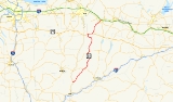
New York State Route 51 (NY 51) is a state highway
in the central part of New York state. The highway runs generally in a southwest to northeast direction from the hamlet of Mount Upton
to the village of Ilion
. NY 51 is a two-lane highway its entire length.
As NY 51 approaches the northern border of Otsego County
, it makes a sharp left before descending to US 20
to the west in West Winfield. A 2.8 miles (4.5 km) concurrency carries it back to the original path where it again heads northward. Then, at Cedarville, it turns left and then right to use a different route, from thence it descends through the winding Ilion Gorge until it reaches Ilion
, where it is known as Otsego Street.
After crossing the Mohawk River
/Erie Canal
, NY 51 ends at NY 5
at a trumpet interchange.
in Mount Upton
as Bridge St, just inside the Chenango County
line. The route heads east from the intersection and enters Otsego County
a mere 0.12 mile (0.1931208 km) later upon crossing the Unadilla River
.
 Once in Otsego County, NY 51 enters the town of Butternuts
. NY 51 continues through Copes Corners, passing by the Gilbertsville-Mount Upton Central School. NY 51 continues to the northeast, eventually heading into the village of Gilbertsville
as Marian Ave. NY 51 soon leaves Gilbertsville, continuing its northeasterly direction. About 2 miles (3.2 km) later, NY 51 enters the town of Morris
. NY 51 continues for a few more miles through rural areas, eventually entering the village of Morris
as Main St. NY 51 intersects with NY 23
in the village of Morris. NY 51 then continues northeast as it leaves the village of Morris. NY 51 soon enters the town of New Lisbon
. NY 51 travels through mostly rural land. It passes through the hamlet of Garrattsville, where it bends to a more northerly direction.
NY 51 then soon enters the town of Burlington
and the hamlet of West Burlington
. At this point, NY 51 joins NY 80
northeastward to Barrett Corners. Here, NY 51 returns to the north and passes through the hamlets of Burlington Flats
and West Exeter on its way northward into Herkimer County
.
, NY 51 meets U.S. Route 20. The two routes join here, overlapping for about 3 miles (5 km) to East Winfield, where NY 51 forks from US 20 and continues northward once more. It passes through the hamlet of Cedarville and Ilion Gorge on its way into the village of Ilion
. Here, NY 51 intersects with NY 5S
before crossing the Mohawk River
(Erie Canal
) into the town of Herkimer
, where it ends at an interchange with NY 5
.
extending from Ilion
to the North Country
via West Winfield
and Utica
. The route began at Route 6 (later NY 5S
and now Clark Street) in Ilion and followed what is now NY 51 southwest to West Winfield. At the center of the village, Route 23 continued west toward Utica on modern U.S. Route 20. In 1912, Route 23 was truncated to begin at the western village line of West Winfield while the portion of the route east of that point became Route 23-a. The change was reverted on March 1, 1921, moving the start of Route 23 back to Ilion.
In the mid-1920s, the segment of modern NY 51 between West Burlington
and West Winfield was designated as part of NY 44, a route that extended south from West Burlington to Sidney
and north from West Winfield to Utica. At the time, this was the only substantial segment of what is now NY 51 to have a route number even though all of modern NY 51 south of Ilion was state-maintained. In the 1930 renumbering of state highways in New York, most of NY 44 became part of NY 8
. The section from West Burlington to West Winfield, however, became part of the new NY 51, which utilized all of its modern routing from Mount Upton
to Ilion upon assignment. It was extended across the Mohawk River
to NY 5
in North Ilion in the mid-1960s.
State highway
State highway, state road or state route can refer to one of three related concepts, two of them related to a state or provincial government in a country that is divided into states or provinces :#A...
in the central part of New York state. The highway runs generally in a southwest to northeast direction from the hamlet of Mount Upton
Mount Upton, New York
Mount Upton is a hamlet on the Unadilla River in the town of Guilford in Chenango County, New York, United States....
to the village of Ilion
Ilion, New York
Ilion is a village in Herkimer County, New York, United States. The population was 8,610 at the 2000 census. Ilion is a name for the ancient city of Troy.The Village of Ilion is at the north town line of the Town of German Flatts...
. NY 51 is a two-lane highway its entire length.
As NY 51 approaches the northern border of Otsego County
Otsego County, New York
Otsego County is a county located in the U.S. state of New York. The 2010 population was 62,259. The county seat is Cooperstown. The name Otsego is from a Mohawk word meaning "place of the rock."-History:...
, it makes a sharp left before descending to US 20
U.S. Route 20
U.S. Route 20 is an east–west United States highway. As the "0" in its route number implies, US 20 is a coast-to-coast route. Spanning , it is the longest road in the United States, and the route sparsely parallels Interstate 90...
to the west in West Winfield. A 2.8 miles (4.5 km) concurrency carries it back to the original path where it again heads northward. Then, at Cedarville, it turns left and then right to use a different route, from thence it descends through the winding Ilion Gorge until it reaches Ilion
Ilion, New York
Ilion is a village in Herkimer County, New York, United States. The population was 8,610 at the 2000 census. Ilion is a name for the ancient city of Troy.The Village of Ilion is at the north town line of the Town of German Flatts...
, where it is known as Otsego Street.
After crossing the Mohawk River
Mohawk River
The Mohawk River is a river in the U.S. state of New York. It is the largest tributary of the Hudson River. The Mohawk flows into the Hudson in the Capital District, a few miles north of the city of Albany. The river is named for the Mohawk Nation of the Iroquois Confederacy...
/Erie Canal
Erie Canal
The Erie Canal is a waterway in New York that runs about from Albany, New York, on the Hudson River to Buffalo, New York, at Lake Erie, completing a navigable water route from the Atlantic Ocean to the Great Lakes. The canal contains 36 locks and encompasses a total elevation differential of...
, NY 51 ends at NY 5
New York State Route 5
New York State Route 5 is a state highway that extends for across the state of New York in the United States. It begins at the Pennsylvania state line in the Chautauqua County town of Ripley and passes through Buffalo, Syracuse, Utica, Schenectady, and several other smaller cities and...
at a trumpet interchange.
Chenango and Otsego Counties
NY 51 begins at an intersection with NY 8New York State Route 8
New York State Route 8 is a state highway in the central part of New York in the United States. It runs in a southwest-to-northeast direction from the Southern Tier to the northern part of Lake George. The southern terminus of the route is at an interchange with NY 17 in the town of...
in Mount Upton
Mount Upton, New York
Mount Upton is a hamlet on the Unadilla River in the town of Guilford in Chenango County, New York, United States....
as Bridge St, just inside the Chenango County
Chenango County, New York
Chenango County is a county located in the U.S. state of New York. As of the 2010 census, the population was 50,477. The county's name originates from an Oneida word meaning "large bull-thistle." Its county seat is Norwich.-History:...
line. The route heads east from the intersection and enters Otsego County
Otsego County, New York
Otsego County is a county located in the U.S. state of New York. The 2010 population was 62,259. The county seat is Cooperstown. The name Otsego is from a Mohawk word meaning "place of the rock."-History:...
a mere 0.12 mile (0.1931208 km) later upon crossing the Unadilla River
Unadilla River
The Unadilla River in New York State flows from south of Utica to the village of Sidney, where it flows into the Susquehanna River, which eventually empties into the Chesapeake Bay, an arm of the Atlantic Ocean....
.
Butternuts, New York
Butternuts is a town located in Otsego County, New York, USA. As of the 2000 census, the town had a population of 1,792. The town name is derived from a stream flowing through the town....
. NY 51 continues through Copes Corners, passing by the Gilbertsville-Mount Upton Central School. NY 51 continues to the northeast, eventually heading into the village of Gilbertsville
Gilbertsville, New York
Gilbertsville is a village in Otsego County, New York, United States. The population was 375 at the 2000 census. The village is named after its founder, and early landowner Abijah Gilbert of Nuneaton, England, father of the eponymous United States Senator from Florida.The Village of Gilbertsville...
as Marian Ave. NY 51 soon leaves Gilbertsville, continuing its northeasterly direction. About 2 miles (3.2 km) later, NY 51 enters the town of Morris
Morris (town), New York
The town of Morris is located in Otsego County, New York, USA. As of the 2000 census, the town had a population of 1,867. The town is named after General Jacob Morris....
. NY 51 continues for a few more miles through rural areas, eventually entering the village of Morris
Morris (village), New York
Morris is a village in Otsego County, New York, United States. The population was 591 at the 2000 census.The Village of Morris is centrally located in the Town of Morris and is northwest of the City of Oneonta.- History :...
as Main St. NY 51 intersects with NY 23
New York State Route 23
New York State Route 23 is an east–west state highway in the eastern portion New York in the United States. It extends for from an intersection with NY 26 in the Central New York town of Cincinnatus to the Massachusetts state line in the Berkshire Mountains, where it continues east as...
in the village of Morris. NY 51 then continues northeast as it leaves the village of Morris. NY 51 soon enters the town of New Lisbon
New Lisbon, New York
New Lisbon is a town in Otsego County, New York, United States. The population was 1,116 at the 2000 census.The Town of New Lisbon is in the west-central part of the county. It is north of the City of Oneonta.- History :...
. NY 51 travels through mostly rural land. It passes through the hamlet of Garrattsville, where it bends to a more northerly direction.
NY 51 then soon enters the town of Burlington
Burlington, New York
Burlington is a town in Otsego County, New York, USA. The population was 1,085 at the 2000 census.The Town of Burlington is in the northwest part of the county and is north of Oneonta.-Geography:...
and the hamlet of West Burlington
West Burlington, New York
West Burlington is a hamlet in the western part of the Town of Burlington in Otsego County, New York. It is located at , three miles east of the town of Edmeston on New York State Route 51 and New York State Route 80....
. At this point, NY 51 joins NY 80
New York State Route 80
New York State Route 80 is a west–east New York State Route located within Onondaga, Madison, Chenango, Otsego, Herkimer, and Montgomery Counties in New York. Its western terminus is located at a junction with NY 175 in the city of Syracuse in Onondaga County, from which it...
northeastward to Barrett Corners. Here, NY 51 returns to the north and passes through the hamlets of Burlington Flats
Burlington Flats, New York
Burlington Flats is a hamlet in the Town of Burlington in Otsego County, New York. It is located at coordinates . Originally named Walbridge Flats for the owner of the mill which still stands on the Wharton Creek....
and West Exeter on its way northward into Herkimer County
Herkimer County, New York
Herkimer County is a county located in the U.S. state of New York. It was created in 1791 north of the Mohawk River out of part of Montgomery County. As of the 2010 census, the population was 64,519. It is named after General Nicholas Herkimer, who died from battle wounds in 1777 after taking part...
.
Herkimer County
North of the county line in the village of West WinfieldWest Winfield, New York
West Winfield is a village in the town of Winfield in Herkimer County, New York, United States. The population was 862 at the 2000 census. The village is indirectly named after General Winfield Scott, for whom the town is named...
, NY 51 meets U.S. Route 20. The two routes join here, overlapping for about 3 miles (5 km) to East Winfield, where NY 51 forks from US 20 and continues northward once more. It passes through the hamlet of Cedarville and Ilion Gorge on its way into the village of Ilion
Ilion, New York
Ilion is a village in Herkimer County, New York, United States. The population was 8,610 at the 2000 census. Ilion is a name for the ancient city of Troy.The Village of Ilion is at the north town line of the Town of German Flatts...
. Here, NY 51 intersects with NY 5S
New York State Route 5S
New York State Route 5S is an east–west state highway located in the Mohawk Valley of New York in the United States. It extends for from an interchange with NY 5, NY 5A, NY 8, and NY 12 in Utica to a smaller interchange with NY 890 in Rotterdam...
before crossing the Mohawk River
Mohawk River
The Mohawk River is a river in the U.S. state of New York. It is the largest tributary of the Hudson River. The Mohawk flows into the Hudson in the Capital District, a few miles north of the city of Albany. The river is named for the Mohawk Nation of the Iroquois Confederacy...
(Erie Canal
Erie Canal
The Erie Canal is a waterway in New York that runs about from Albany, New York, on the Hudson River to Buffalo, New York, at Lake Erie, completing a navigable water route from the Atlantic Ocean to the Great Lakes. The canal contains 36 locks and encompasses a total elevation differential of...
) into the town of Herkimer
Herkimer (town), New York
Herkimer is a town in Herkimer County, New York, United States, southeast of Utica. It is named after Nicholas Herkimer. The population was 9,962 at the 2000 census.The town contains a village also called Herkimer...
, where it ends at an interchange with NY 5
New York State Route 5
New York State Route 5 is a state highway that extends for across the state of New York in the United States. It begins at the Pennsylvania state line in the Chautauqua County town of Ripley and passes through Buffalo, Syracuse, Utica, Schenectady, and several other smaller cities and...
.
History
In 1908, the New York State Legislature created Route 23, an unsigned legislative routeLegislative route
In United States, a legislative route or legislative highway is a highway defined by laws passed in a state legislature. The numbering of such highways may or may not correspond to the numbers familiar to the public as part of the state, U.S. highway, and Interstate highway systems...
extending from Ilion
Ilion, New York
Ilion is a village in Herkimer County, New York, United States. The population was 8,610 at the 2000 census. Ilion is a name for the ancient city of Troy.The Village of Ilion is at the north town line of the Town of German Flatts...
to the North Country
North Country, New York
The North Country is a region of the U.S. state of New York that encompasses the state's extreme northern frontier, bordering Lake Ontario on the west, the Saint Lawrence River and the Canadian provinces of Ontario and Quebec on the north and northwest, and Lake Champlain and Vermont on the east...
via West Winfield
West Winfield, New York
West Winfield is a village in the town of Winfield in Herkimer County, New York, United States. The population was 862 at the 2000 census. The village is indirectly named after General Winfield Scott, for whom the town is named...
and Utica
Utica, New York
Utica is a city in and the county seat of Oneida County, New York, United States. The population was 62,235 at the 2010 census, an increase of 2.6% from the 2000 census....
. The route began at Route 6 (later NY 5S
New York State Route 5S
New York State Route 5S is an east–west state highway located in the Mohawk Valley of New York in the United States. It extends for from an interchange with NY 5, NY 5A, NY 8, and NY 12 in Utica to a smaller interchange with NY 890 in Rotterdam...
and now Clark Street) in Ilion and followed what is now NY 51 southwest to West Winfield. At the center of the village, Route 23 continued west toward Utica on modern U.S. Route 20. In 1912, Route 23 was truncated to begin at the western village line of West Winfield while the portion of the route east of that point became Route 23-a. The change was reverted on March 1, 1921, moving the start of Route 23 back to Ilion.
In the mid-1920s, the segment of modern NY 51 between West Burlington
West Burlington, New York
West Burlington is a hamlet in the western part of the Town of Burlington in Otsego County, New York. It is located at , three miles east of the town of Edmeston on New York State Route 51 and New York State Route 80....
and West Winfield was designated as part of NY 44, a route that extended south from West Burlington to Sidney
Sidney (village), New York
Sidney is a village in Delaware County, New York, USA. The population was 4,068 at the 2000 census.The Village of Sidney is in west part of the Town of Sidney.-History:The village was named for Admiral Sir Sidney Smith.-Geography:...
and north from West Winfield to Utica. At the time, this was the only substantial segment of what is now NY 51 to have a route number even though all of modern NY 51 south of Ilion was state-maintained. In the 1930 renumbering of state highways in New York, most of NY 44 became part of NY 8
New York State Route 8
New York State Route 8 is a state highway in the central part of New York in the United States. It runs in a southwest-to-northeast direction from the Southern Tier to the northern part of Lake George. The southern terminus of the route is at an interchange with NY 17 in the town of...
. The section from West Burlington to West Winfield, however, became part of the new NY 51, which utilized all of its modern routing from Mount Upton
Mount Upton, New York
Mount Upton is a hamlet on the Unadilla River in the town of Guilford in Chenango County, New York, United States....
to Ilion upon assignment. It was extended across the Mohawk River
Mohawk River
The Mohawk River is a river in the U.S. state of New York. It is the largest tributary of the Hudson River. The Mohawk flows into the Hudson in the Capital District, a few miles north of the city of Albany. The river is named for the Mohawk Nation of the Iroquois Confederacy...
to NY 5
New York State Route 5
New York State Route 5 is a state highway that extends for across the state of New York in the United States. It begins at the Pennsylvania state line in the Chautauqua County town of Ripley and passes through Buffalo, Syracuse, Utica, Schenectady, and several other smaller cities and...
in North Ilion in the mid-1960s.