

Prattsville, New York
Encyclopedia
Prattsville is a town
in Greene County
, New York
, United States
. The Town of Prattsville is in the northwest part of the county. As of the 2010 census, the city population was 700.

 The town was first settled around 1763, and the region was then called "Schoharie Kill." An attempt during the American Revolution
by the British and their Tory allies to drive the settlers out was thwarted when they were defeated by the settlers.
Prattsville was established in 1824 from the Town of Windham. Some of the town was lost to form the Town of Ashland
in 1848.
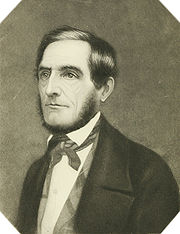
Prattsville was later named after Zadock Pratt
, a congressman and prominent citizen. Pratt built a tannery larger than any other in the world at the time, helping it become a major town in Upstate New York. His life is depicted through as series of stone carvings called Pratt Rock
which he commissioned during his lifetime.
The 1830 population of the town was 830. When Pratt built his tannery, it created a vast number of jobs and the population grew to 1989 by 1850. However, by 1845 all of the Hemlock bark had been extracted from the forests for 10 miles around, and Pratt was forced to close the tannery. The jobs that were lost could not be replaced, and the town's population dwindled to 1,314 by 1875. The Old Episcopal Manse
was added to the National Register of Historic Places
in 2000.
It is paradoxical that both the great American naturalist, John Burroughs
, and Jay Gould
, one of the richest men of history were both born and raised in Roxbury,New York
, practically a stone's throw from Prattsville.
On August, 28. 2011, Hurricane Irene
caused record flooding in the town by the Schoharie Creek
, causing major damage and destroying large areas of the town. It received widespread national news coverage because the town had nearly been washed away.
, the town has a total area of 19.7 square miles (51 km²), of which, 19.6 square miles (50.8 km²) of it is land and 0.1 square mile (0.258998811 km²) of it (0.51%) is water.
The town is in the Catskill Mountains
. The north town line is the border of Schoharie County
, New York
, and the west town line is the border of Delaware County
, New York
.
The Schoharie Creek
flows through the town past the community of Prattsville.
of 2000, there were 665 people, 253 households, and 182 families residing in the town. The population density
was 33.9 people per square mile (13.1/km²). There were 406 housing units at an average density of 20.7 per square mile (8.0/km²). The racial makeup of the town was 98.95% White, 0.30% Native American, 0.15% Asian, and 0.60% from two or more races. Hispanic or Latino of any race were 1.35% of the population.
There were 253 households out of which 36.4% had children under the age of 18 living with them, 56.9% were married couples
living together, 9.9% had a female householder with no husband present, and 27.7% were non-families. 22.1% of all households were made up of individuals and 13.0% had someone living alone who was 65 years of age or older. The average household size was 2.61 and the average family size was 3.04.
In the town the population was spread out with 25.9% under the age of 18, 5.7% from 18 to 24, 27.8% from 25 to 44, 22.0% from 45 to 64, and 18.6% who were 65 years of age or older. The median age was 36 years. For every 100 females there were 92.8 males. For every 100 females age 18 and over, there were 94.9 males.
The median income for a household in the town was $30,655, and the median income for a family was $33,571. Males had a median income of $35,313 versus $17,917 for females. The per capita income
for the town was $14,962. About 4.9% of families and 11.5% of the population were below the poverty line, including 16.3% of those under age 18 and 7.4% of those age 65 or over.
A number of homes in the area are second/vacation homes owned by those wealthier than the average Prattsville resident.
Town
A town is a human settlement larger than a village but smaller than a city. The size a settlement must be in order to be called a "town" varies considerably in different parts of the world, so that, for example, many American "small towns" seem to British people to be no more than villages, while...
in Greene County
Greene County, New York
Greene County is a county located in the U.S. state of New York. Its name is in honor of the American Revolutionary War general Nathanael Greene. Its county seat is Catskill...
, New York
New York
New York is a state in the Northeastern region of the United States. It is the nation's third most populous state. New York is bordered by New Jersey and Pennsylvania to the south, and by Connecticut, Massachusetts and Vermont to the east...
, United States
United States
The United States of America is a federal constitutional republic comprising fifty states and a federal district...
. The Town of Prattsville is in the northwest part of the county. As of the 2010 census, the city population was 700.
History
American Revolution
The American Revolution was the political upheaval during the last half of the 18th century in which thirteen colonies in North America joined together to break free from the British Empire, combining to become the United States of America...
by the British and their Tory allies to drive the settlers out was thwarted when they were defeated by the settlers.
Prattsville was established in 1824 from the Town of Windham. Some of the town was lost to form the Town of Ashland
Ashland, New York
Ashland is the name of some places in the U.S. state of New York:*Ashland, Chemung County, New York*Ashland, Greene County, New York...
in 1848.
Prattsville was later named after Zadock Pratt
Zadock Pratt
Zadock Pratt Jr. was a tanner, banker, soldier, and member of the United States House of Representatives...
, a congressman and prominent citizen. Pratt built a tannery larger than any other in the world at the time, helping it become a major town in Upstate New York. His life is depicted through as series of stone carvings called Pratt Rock
Pratt Rock
Pratt Rock, also known as Pratt's Rock, is a rockface or other landform that includes a series of stone carvings in Prattsville, New York depicting the life of Zadock Pratt...
which he commissioned during his lifetime.
The 1830 population of the town was 830. When Pratt built his tannery, it created a vast number of jobs and the population grew to 1989 by 1850. However, by 1845 all of the Hemlock bark had been extracted from the forests for 10 miles around, and Pratt was forced to close the tannery. The jobs that were lost could not be replaced, and the town's population dwindled to 1,314 by 1875. The Old Episcopal Manse
Old Episcopal Manse
Old Episcopal Manse is a historic Episcopal manse building on New York State Route 23, Main Street in Prattsville, Greene County, New York. It was built about 1845 and is a -story, cross-gable house type with Gothic Revival style features. It features board and batten siding and a steeply pitched...
was added to the National Register of Historic Places
National Register of Historic Places
The National Register of Historic Places is the United States government's official list of districts, sites, buildings, structures, and objects deemed worthy of preservation...
in 2000.
It is paradoxical that both the great American naturalist, John Burroughs
John Burroughs
John Burroughs was an American naturalist and essayist important in the evolution of the U.S. conservation movement. According to biographers at the American Memory project at the Library of Congress,...
, and Jay Gould
Jay Gould
Jason "Jay" Gould was a leading American railroad developer and speculator. He has long been vilified as an archetypal robber baron, whose successes made him the ninth richest American in history. Condé Nast Portfolio ranked Gould as the 8th worst American CEO of all time...
, one of the richest men of history were both born and raised in Roxbury,New York
Roxbury, New York
Roxbury is a town in Delaware County, New York, United States. The population was 2,509 at the 2000 census.The Town of Roxbury is at the eastern end of the county.- History :...
, practically a stone's throw from Prattsville.
On August, 28. 2011, Hurricane Irene
Hurricane Irene (2011)
Hurricane Irene was a large and powerful Atlantic hurricane that left extensive flood and wind damage along its path through the Caribbean, the United States East Coast and as far north as Atlantic Canada in 2011...
caused record flooding in the town by the Schoharie Creek
Schoharie Creek
Schoharie Creek in New York, USA flows north from the foot of Indian Head Mountain in the Catskill Mountains through the Schoharie Valley to the Mohawk River. It is twice impounded north of Prattsville to create New York City's Schoharie Reservoir and the Blenheim-Gilboa Power Project.Two notable...
, causing major damage and destroying large areas of the town. It received widespread national news coverage because the town had nearly been washed away.
Geography
According to the United States Census BureauUnited States Census Bureau
The United States Census Bureau is the government agency that is responsible for the United States Census. It also gathers other national demographic and economic data...
, the town has a total area of 19.7 square miles (51 km²), of which, 19.6 square miles (50.8 km²) of it is land and 0.1 square mile (0.258998811 km²) of it (0.51%) is water.
The town is in the Catskill Mountains
Catskill Mountains
The Catskill Mountains, an area in New York State northwest of New York City and southwest of Albany, are a mature dissected plateau, an uplifted region that was subsequently eroded into sharp relief. They are an eastward continuation, and the highest representation, of the Allegheny Plateau...
. The north town line is the border of Schoharie County
Schoharie County, New York
As of the census of 2000, there were 31,582 people, 11,991 households and 8,177 families residing in the county. The population density was 51 people per square mile . There were 15,915 housing units at an average density of 26 per square mile...
, New York
New York
New York is a state in the Northeastern region of the United States. It is the nation's third most populous state. New York is bordered by New Jersey and Pennsylvania to the south, and by Connecticut, Massachusetts and Vermont to the east...
, and the west town line is the border of Delaware County
Delaware County, New York
Delaware County is a county located in the U.S. state of New York. As of 2010 the population was 47,980. The county seat is Delhi. It is named after the Delaware River, which was named in honor of Thomas West, 3rd Baron De La Warr, appointed governor of Virginia in 1609.-History:When counties...
, New York
New York
New York is a state in the Northeastern region of the United States. It is the nation's third most populous state. New York is bordered by New Jersey and Pennsylvania to the south, and by Connecticut, Massachusetts and Vermont to the east...
.
The Schoharie Creek
Schoharie Creek
Schoharie Creek in New York, USA flows north from the foot of Indian Head Mountain in the Catskill Mountains through the Schoharie Valley to the Mohawk River. It is twice impounded north of Prattsville to create New York City's Schoharie Reservoir and the Blenheim-Gilboa Power Project.Two notable...
flows through the town past the community of Prattsville.
Demographics
As of the censusCensus
A census is the procedure of systematically acquiring and recording information about the members of a given population. It is a regularly occurring and official count of a particular population. The term is used mostly in connection with national population and housing censuses; other common...
of 2000, there were 665 people, 253 households, and 182 families residing in the town. The population density
Population density
Population density is a measurement of population per unit area or unit volume. It is frequently applied to living organisms, and particularly to humans...
was 33.9 people per square mile (13.1/km²). There were 406 housing units at an average density of 20.7 per square mile (8.0/km²). The racial makeup of the town was 98.95% White, 0.30% Native American, 0.15% Asian, and 0.60% from two or more races. Hispanic or Latino of any race were 1.35% of the population.
There were 253 households out of which 36.4% had children under the age of 18 living with them, 56.9% were married couples
Marriage
Marriage is a social union or legal contract between people that creates kinship. It is an institution in which interpersonal relationships, usually intimate and sexual, are acknowledged in a variety of ways, depending on the culture or subculture in which it is found...
living together, 9.9% had a female householder with no husband present, and 27.7% were non-families. 22.1% of all households were made up of individuals and 13.0% had someone living alone who was 65 years of age or older. The average household size was 2.61 and the average family size was 3.04.
In the town the population was spread out with 25.9% under the age of 18, 5.7% from 18 to 24, 27.8% from 25 to 44, 22.0% from 45 to 64, and 18.6% who were 65 years of age or older. The median age was 36 years. For every 100 females there were 92.8 males. For every 100 females age 18 and over, there were 94.9 males.
The median income for a household in the town was $30,655, and the median income for a family was $33,571. Males had a median income of $35,313 versus $17,917 for females. The per capita income
Per capita income
Per capita income or income per person is a measure of mean income within an economic aggregate, such as a country or city. It is calculated by taking a measure of all sources of income in the aggregate and dividing it by the total population...
for the town was $14,962. About 4.9% of families and 11.5% of the population were below the poverty line, including 16.3% of those under age 18 and 7.4% of those age 65 or over.
A number of homes in the area are second/vacation homes owned by those wealthier than the average Prattsville resident.
Climate
Communities and locations in Prattsville
- Four Corners – A hamletHamlet (place)A hamlet is usually a rural settlement which is too small to be considered a village, though sometimes the word is used for a different sort of community. Historically, when a hamlet became large enough to justify building a church, it was then classified as a village...
on the east town line, northeast of Prattsville village. - Pratt Rocks – A collection of rock carvings east of Prattsville village.
- Prattsville – The hamlet of Prattsville is in the south part of the town on Route 23A. It was incorporated as a village in 1883, but later abandoned that status.
- Red Falls – A hamlet in the southeast part of the town on Route 23.