
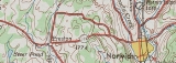
New York State Route 319
Encyclopedia
New York State Route 319 (NY 319) was a state highway
in Chenango County, New York
, in the United States
. It was 5.47 miles (8.8 km) long and connected the hamlet of Preston to the nearby city of Norwich
. The route began in Preston hamlet at an intersection with three county-maintained highways and proceeded eastward through the town of Preston
to downtown Norwich, where it terminated at an intersection with NY 12
.
What became NY 319 was originally built during the early 19th century as the Norwich and Preston Turnpike, one of many privately-maintained turnpikes in the state of New York
. The state of New York assumed ownership of the turnpike's routing in the early 20th century. The Preston–Norwich state highway was designated as NY 319 as part of the 1930 renumbering of state highways in New York. Maintenance of NY 319 was handled by the New York State Department of Transportation
west of the Norwich city limits and by the city of Norwich within the city.
Ownership and maintenance of the state-maintained section of NY 319 was slated to be transferred from New York to Chenango County as part of a highway maintenance swap approved by the New York State Legislature. The swap was contingent on the completion of a new alignment for NY 23
in northwestern Chenango County. The new highway was completed in July 1984, at which time maintenance of NY 319's routing west of Norwich became the responsibility of Chenango County and the NY 319 designation was completely removed. The Chenango County-owned section of NY 319's former routing was subsequently redesignated as County Route 10A (CR 10A).
. The highway proceeded northeastward, climbing the side of a hill approximately 1560 feet (475.5 m) in elevation at its peak. Continuing eastward, NY 319 continued to climb in elevation, reaching 1760 feet (536.4 m) near Packer–Mason Cemetery. From here, the route descended into a valley separating two large hills with peaks approximately 1800 feet (548.6 m) above sea level
. East of the hills, NY 319 entered the town of Norwich
and intersected CR 19 once again.
Past its junction with CR 19, NY 319 turned southeastward and descended the western edge of a large valley surrounding the Chenango River
. At the base of the valley, the route turned eastward and crossed over Canasawacta Creek, a tributary of the Chenango River, as it entered the city of Norwich
and became West Main Street. Here, maintenance of NY 319 shifted from the New York State Department of Transportation
(NYSDOT) to the city of Norwich. In Norwich, NY 319 passed a mixture of residential and commercial establishments before intersecting with NY 12
(Broad Street) in the city's downtown district. NY 319 ended here; however, Main Street continued east of NY 12 as NY 990L
, a partially unsigned reference route maintained by NYSDOT.
 The town of Norwich
was created on January 19, 1793, and was originally much larger than it is today. On April 2, 1806, part of the town was split off to form a new town named Preston
. A charter on April 8, 1808, established the Norwich and Preston Turnpike, a turnpike
connecting the town of Preston in the west to the town of Norwich in the east. The Norwich and Preston Turnpike was privately owned and maintained, as most turnpikes in New York were at the time.
The routing of the Norwich and Preston Turnpike was taken over by the state of New York
in the early 20th century. On December 14, 1907, a contract was let to improve a 4.86 miles (7.82 km) long portion of the former turnpike. Construction cost $57,714 (equivalent to $ in ) and was completed by late 1908. The improved highway was added to the state highway system on November 16, 1908. A second contract to improve an additional 0.22 mile (0.3540548 km) of the turnpike was let on April 9, 1910. Work on this segment cost approximately $6,000 (equivalent to $ in ) and was completed by mid-1911. This section of the turnpike was accepted into the state highway system on July 22, 1911. The first set of posted routes in New York were assigned in 1924; however, none of the former Norwich and Preston Turnpike was assigned a designation at that time.
west of the Norwich
city limits and by the city of Norwich within the city. The alignment of NY 319 remained unchanged for the next half-century.
 Ownership and maintenance of NY 319 west of the Norwich city limits was slated to be transferred from the state of New York to Chenango County
as part of a highway maintenance swap approved by the New York State Legislature. However, the swap in maintenance was contingent on the construction and completion of a new alignment for NY 23
in northwestern Chenango County between the Chenango–Cortland County
border and the hamlet of Scotts Corners. At the time, NY 23 began at NY 26
in northwest Pharsalia
and followed an easterly and southerly routing to Scotts Corners. From there, it continued east on its modern alignment. The portion of the exchange describing the roads that would be transferred to Chenango County is written in New York State Highway Law as follows, with annotations in parentheses:
The new highway in the towns of Pitcher
and Pharsalia was completed in July 1984, at which time NY 23 was rerouted to follow the highway and the entirety of the pre-approved highway maintenance swap went into effect. Thus, ownership and maintenance of NY 23's old alignment through Pharsalia and the entirety of NY 319 west of Norwich was transferred to Chenango County. The former alignment of NY 23 became CR 42 while the now county-maintained section of NY 319 was redesignated as CR 10A, a spur of the pre-existing CR 10. The NY 319 designation was also removed from West Main Street in the city of Norwich at this time.
_in_norwich.jpg) In 1997, the bridge that had carried NY 319 over Gilmore Brook in the town of Preston was replaced. The 29.1 feet (8.9 m) long structure handles an average
In 1997, the bridge that had carried NY 319 over Gilmore Brook in the town of Preston was replaced. The 29.1 feet (8.9 m) long structure handles an average
of 1,154 vehicles per day. Farther east, the 74.1 feet (22.6 m) long bridge over Canasawacta Creek was also reconstructed in 1997. It was built in 1937 and carries an average of 2,093 cars per day.
State highway
State highway, state road or state route can refer to one of three related concepts, two of them related to a state or provincial government in a country that is divided into states or provinces :#A...
in Chenango County, New York
Chenango County, New York
Chenango County is a county located in the U.S. state of New York. As of the 2010 census, the population was 50,477. The county's name originates from an Oneida word meaning "large bull-thistle." Its county seat is Norwich.-History:...
, in the United States
United States
The United States of America is a federal constitutional republic comprising fifty states and a federal district...
. It was 5.47 miles (8.8 km) long and connected the hamlet of Preston to the nearby city of Norwich
Norwich (city), New York
Norwich is a city in Chenango County, New York, United States. Surrounded on all sides by the Town of Norwich, the city is the county seat of Chenango County. The name is taken from Norwich, Connecticut. Its population was 7,355 at the 2000 census.Lt...
. The route began in Preston hamlet at an intersection with three county-maintained highways and proceeded eastward through the town of Preston
Preston, New York
Preston is a town in Chenango County, New York, United States. The population was 928 at the 2000 census.The Town of Preston is an interior town of Chenango County. The town is west of the City of Norwich.- History :...
to downtown Norwich, where it terminated at an intersection with NY 12
New York State Route 12
New York State Route 12 is a state highway extending for through central and northern New York in the United States. The southern terminus of the route is at U.S. Route 11 in the town of Chenango in the Southern Tier. The northern terminus is at NY 37 near the village of...
.
What became NY 319 was originally built during the early 19th century as the Norwich and Preston Turnpike, one of many privately-maintained turnpikes in the state of New York
New York
New York is a state in the Northeastern region of the United States. It is the nation's third most populous state. New York is bordered by New Jersey and Pennsylvania to the south, and by Connecticut, Massachusetts and Vermont to the east...
. The state of New York assumed ownership of the turnpike's routing in the early 20th century. The Preston–Norwich state highway was designated as NY 319 as part of the 1930 renumbering of state highways in New York. Maintenance of NY 319 was handled by the New York State Department of Transportation
New York State Department of Transportation
The New York State Department of Transportation is responsible for the development and operation of highways, railroads, mass transit systems, ports, waterways and aviation facilities in the U.S...
west of the Norwich city limits and by the city of Norwich within the city.
Ownership and maintenance of the state-maintained section of NY 319 was slated to be transferred from New York to Chenango County as part of a highway maintenance swap approved by the New York State Legislature. The swap was contingent on the completion of a new alignment for NY 23
New York State Route 23
New York State Route 23 is an east–west state highway in the eastern portion New York in the United States. It extends for from an intersection with NY 26 in the Central New York town of Cincinnatus to the Massachusetts state line in the Berkshire Mountains, where it continues east as...
in northwestern Chenango County. The new highway was completed in July 1984, at which time maintenance of NY 319's routing west of Norwich became the responsibility of Chenango County and the NY 319 designation was completely removed. The Chenango County-owned section of NY 319's former routing was subsequently redesignated as County Route 10A (CR 10A).
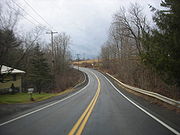
Route description
NY 319 began at an intersection with three county routes (CR 4, CR 10, and CR 19) in the hamlet of Preston, a small community in the northern portion of the town of the same namePreston, New York
Preston is a town in Chenango County, New York, United States. The population was 928 at the 2000 census.The Town of Preston is an interior town of Chenango County. The town is west of the City of Norwich.- History :...
. The highway proceeded northeastward, climbing the side of a hill approximately 1560 feet (475.5 m) in elevation at its peak. Continuing eastward, NY 319 continued to climb in elevation, reaching 1760 feet (536.4 m) near Packer–Mason Cemetery. From here, the route descended into a valley separating two large hills with peaks approximately 1800 feet (548.6 m) above sea level
Sea level
Mean sea level is a measure of the average height of the ocean's surface ; used as a standard in reckoning land elevation...
. East of the hills, NY 319 entered the town of Norwich
Norwich (town), New York
Norwich is a town in Chenango County, New York, United States. The population was 3,836 at the 2000 census. The town was named after Norwich, Connecticut.The Town of Norwich is located near the center of the county...
and intersected CR 19 once again.
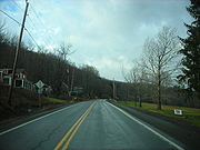
Past its junction with CR 19, NY 319 turned southeastward and descended the western edge of a large valley surrounding the Chenango River
Chenango River
The Chenango River is a tributary of the Susquehanna River in central New York in the United States. It drains a dissected plateau area in upstate New York at the northern end of the Susquehanna watershed....
. At the base of the valley, the route turned eastward and crossed over Canasawacta Creek, a tributary of the Chenango River, as it entered the city of Norwich
Norwich (city), New York
Norwich is a city in Chenango County, New York, United States. Surrounded on all sides by the Town of Norwich, the city is the county seat of Chenango County. The name is taken from Norwich, Connecticut. Its population was 7,355 at the 2000 census.Lt...
and became West Main Street. Here, maintenance of NY 319 shifted from the New York State Department of Transportation
New York State Department of Transportation
The New York State Department of Transportation is responsible for the development and operation of highways, railroads, mass transit systems, ports, waterways and aviation facilities in the U.S...
(NYSDOT) to the city of Norwich. In Norwich, NY 319 passed a mixture of residential and commercial establishments before intersecting with NY 12
New York State Route 12
New York State Route 12 is a state highway extending for through central and northern New York in the United States. The southern terminus of the route is at U.S. Route 11 in the town of Chenango in the Southern Tier. The northern terminus is at NY 37 near the village of...
(Broad Street) in the city's downtown district. NY 319 ended here; however, Main Street continued east of NY 12 as NY 990L
New York State Route 990L
New York State Route 990L is a reference route in Chenango County, New York, United States. The western terminus of the route is at an intersection with NY 12 in the city of Norwich. Its eastern terminus is at a junction with NY 23 in the town of Norwich...
, a partially unsigned reference route maintained by NYSDOT.
Norwich and Preston Turnpike
Norwich (town), New York
Norwich is a town in Chenango County, New York, United States. The population was 3,836 at the 2000 census. The town was named after Norwich, Connecticut.The Town of Norwich is located near the center of the county...
was created on January 19, 1793, and was originally much larger than it is today. On April 2, 1806, part of the town was split off to form a new town named Preston
Preston, New York
Preston is a town in Chenango County, New York, United States. The population was 928 at the 2000 census.The Town of Preston is an interior town of Chenango County. The town is west of the City of Norwich.- History :...
. A charter on April 8, 1808, established the Norwich and Preston Turnpike, a turnpike
Toll road
A toll road is a privately or publicly built road for which a driver pays a toll for use. Structures for which tolls are charged include toll bridges and toll tunnels. Non-toll roads are financed using other sources of revenue, most typically fuel tax or general tax funds...
connecting the town of Preston in the west to the town of Norwich in the east. The Norwich and Preston Turnpike was privately owned and maintained, as most turnpikes in New York were at the time.
The routing of the Norwich and Preston Turnpike was taken over by the state of New York
New York
New York is a state in the Northeastern region of the United States. It is the nation's third most populous state. New York is bordered by New Jersey and Pennsylvania to the south, and by Connecticut, Massachusetts and Vermont to the east...
in the early 20th century. On December 14, 1907, a contract was let to improve a 4.86 miles (7.82 km) long portion of the former turnpike. Construction cost $57,714 (equivalent to $ in ) and was completed by late 1908. The improved highway was added to the state highway system on November 16, 1908. A second contract to improve an additional 0.22 mile (0.3540548 km) of the turnpike was let on April 9, 1910. Work on this segment cost approximately $6,000 (equivalent to $ in ) and was completed by mid-1911. This section of the turnpike was accepted into the state highway system on July 22, 1911. The first set of posted routes in New York were assigned in 1924; however, none of the former Norwich and Preston Turnpike was assigned a designation at that time.
Designation and removal
In the 1930 renumbering of state highways in New York, several of the routes assigned during the 1920s were renumbered or modified. At the same time, hundreds of state-maintained highways that did not yet have a route number were assigned one. One of these highways was the Preston–Norwich state highway, which was designated as NY 319. Maintenance of NY 319 was handled by the New York State Department of TransportationNew York State Department of Transportation
The New York State Department of Transportation is responsible for the development and operation of highways, railroads, mass transit systems, ports, waterways and aviation facilities in the U.S...
west of the Norwich
Norwich (city), New York
Norwich is a city in Chenango County, New York, United States. Surrounded on all sides by the Town of Norwich, the city is the county seat of Chenango County. The name is taken from Norwich, Connecticut. Its population was 7,355 at the 2000 census.Lt...
city limits and by the city of Norwich within the city. The alignment of NY 319 remained unchanged for the next half-century.
Chenango County, New York
Chenango County is a county located in the U.S. state of New York. As of the 2010 census, the population was 50,477. The county's name originates from an Oneida word meaning "large bull-thistle." Its county seat is Norwich.-History:...
as part of a highway maintenance swap approved by the New York State Legislature. However, the swap in maintenance was contingent on the construction and completion of a new alignment for NY 23
New York State Route 23
New York State Route 23 is an east–west state highway in the eastern portion New York in the United States. It extends for from an intersection with NY 26 in the Central New York town of Cincinnatus to the Massachusetts state line in the Berkshire Mountains, where it continues east as...
in northwestern Chenango County between the Chenango–Cortland County
Cortland County, New York
Cortland County is a county located in the U.S. state of New York, named after Federico Van Cortlandt, president of the convention at Kingston that wrote the first New York State Constitution in 1777, and first lieutenant governor of the state. The county seat is Cortland...
border and the hamlet of Scotts Corners. At the time, NY 23 began at NY 26
New York State Route 26
New York State Route 26 is a north–south state highway that runs for through Central New York in the United States. Its southern terminus is located at the Pennsylvania state line south of the town of Vestal in Broome County, where it becomes Pennsylvania Route 267...
in northwest Pharsalia
Pharsalia, New York
Pharsalia is a town in Chenango County, New York, United States. The population was 542 at the 2000 census. Pharsalia is a name related to the location of Julius Caesar's victory over Pompey....
and followed an easterly and southerly routing to Scotts Corners. From there, it continued east on its modern alignment. The portion of the exchange describing the roads that would be transferred to Chenango County is written in New York State Highway Law as follows, with annotations in parentheses:
... to enter an official order of abandonment to the county of Chenango of that portion of state highway eight hundred seven (NY 23) easterly and southeasterly from state highways eight thousand one hundred sixty-one and six hundred sixty-three (NY 26) to its intersection with the [new alignment of NY 23], all of state highways five hundred ninety-eight-a and five hundred ninety-eight (NY 319) ...
The new highway in the towns of Pitcher
Pitcher, New York
Pitcher is a town in Chenango County, New York, United States. The population was 848 at the 2000 census. The town is named after Nathaniel Pitcher, a Lt...
and Pharsalia was completed in July 1984, at which time NY 23 was rerouted to follow the highway and the entirety of the pre-approved highway maintenance swap went into effect. Thus, ownership and maintenance of NY 23's old alignment through Pharsalia and the entirety of NY 319 west of Norwich was transferred to Chenango County. The former alignment of NY 23 became CR 42 while the now county-maintained section of NY 319 was redesignated as CR 10A, a spur of the pre-existing CR 10. The NY 319 designation was also removed from West Main Street in the city of Norwich at this time.
Post-designation
Annual average daily traffic
Average Annual daily traffic, abbreviated AADT, is a measure used primarily in transportation planning and transportation engineering. It is the total volume of vehicle traffic of a highway or road for a year divided by 365 days. AADT is a useful and simple measurement of how busy the road is...
of 1,154 vehicles per day. Farther east, the 74.1 feet (22.6 m) long bridge over Canasawacta Creek was also reconstructed in 1997. It was built in 1937 and carries an average of 2,093 cars per day.