

Mountain peaks of the United States
Encyclopedia
Summit (topography)
In topography, a summit is a point on a surface that is higher in elevation than all points immediately adjacent to it. Mathematically, a summit is a local maximum in elevation...
of the United States of America
United States
The United States of America is a federal constitutional republic comprising fifty states and a federal district...
.
Topographic elevation is the vertical distance above the reference geoid
Geoid
The geoid is that equipotential surface which would coincide exactly with the mean ocean surface of the Earth, if the oceans were in equilibrium, at rest , and extended through the continents . According to C.F...
, a precise mathematical model of the Earth's sea level
Sea level
Mean sea level is a measure of the average height of the ocean's surface ; used as a standard in reckoning land elevation...
as an equipotential
Equipotential
Equipotential or isopotential in mathematics and physics refers to a region in space where every point in it is at the same potential. This usually refers to a scalar potential , although it can also be applied to vector potentials...
gravitational surface. Topographic prominence
Topographic prominence
In topography, prominence, also known as autonomous height, relative height, shoulder drop , or prime factor , categorizes the height of the mountain's or hill's summit by the elevation between it and the lowest contour line encircling it and no higher summit...
is the elevation difference between the summit and the highest or key col to a higher summit. Topographic isolation
Topographic isolation
The topographic isolation of a summit is the minimum horizontal distance to the nearest point of higher elevation. Topographic isolation represents a radius of dominance in which the summit is the highest point. Topographic isolation can be calculated for small hills and islands as well as for...
is the minimum great circle
Great circle
A great circle, also known as a Riemannian circle, of a sphere is the intersection of the sphere and a plane which passes through the center point of the sphere, as opposed to a general circle of a sphere where the plane is not required to pass through the center...
distance to a point of higher elevation.
This article defines a significant summit as a summit with at least 100 meters (328.1 feet) of topographic prominence, and a major summit as a summit with at least 500 meters (1640.4 feet) of topographic prominence. An ultra-prominent summit is a summit with at least 1500 meters (4921.3 feet) of topographic prominence. There are 129 ultra-prominent summits in the United States.
All elevations in the 48 states
U.S. state
A U.S. state is any one of the 50 federated states of the United States of America that share sovereignty with the federal government. Because of this shared sovereignty, an American is a citizen both of the federal entity and of his or her state of domicile. Four states use the official title of...
of the contiguous United States
Contiguous United States
The contiguous United States are the 48 U.S. states on the continent of North America that are south of Canada and north of Mexico, plus the District of Columbia....
include an elevation adjustment from the National Geodetic Vertical Datum of 1929 (NGVD 29) to the North American Vertical Datum of 1988
North American Vertical Datum of 1988
The North American Vertical Datum of 1988 is the vertical control datum of orthometric height established for vertical control surveying in the United States of America based upon the General Adjustment of the North American Datum of 1988....
(NAVD 88). For further information, please see this United States National Geodetic Survey note.
Highest major summits
The following sortable table lists the 50 highest mountain peaksSummit (topography)
In topography, a summit is a point on a surface that is higher in elevation than all points immediately adjacent to it. Mathematically, a summit is a local maximum in elevation...
of the United States
United States
The United States of America is a federal constitutional republic comprising fifty states and a federal district...
with at least 500 meters (1640.4 feet) of topographic prominence
Topographic prominence
In topography, prominence, also known as autonomous height, relative height, shoulder drop , or prime factor , categorizes the height of the mountain's or hill's summit by the elevation between it and the lowest contour line encircling it and no higher summit...
. Of these 50 highest major peaks, 28 are located in Colorado
Colorado
Colorado is a U.S. state that encompasses much of the Rocky Mountains as well as the northeastern portion of the Colorado Plateau and the western edge of the Great Plains...
, 14 in Alaska
Alaska
Alaska is the largest state in the United States by area. It is situated in the northwest extremity of the North American continent, with Canada to the east, the Arctic Ocean to the north, and the Pacific Ocean to the west and south, with Russia further west across the Bering Strait...
, 7 in California
California
California is a state located on the West Coast of the United States. It is by far the most populous U.S. state, and the third-largest by land area...
, and 1 in Washington.
| Rank Ranking A ranking is a relationship between a set of items such that, for any two items, the first is either 'ranked higher than', 'ranked lower than' or 'ranked equal to' the second.... |
Mountain Peak Summit (topography) In topography, a summit is a point on a surface that is higher in elevation than all points immediately adjacent to it. Mathematically, a summit is a local maximum in elevation... |
State U.S. state A U.S. state is any one of the 50 federated states of the United States of America that share sovereignty with the federal government. Because of this shared sovereignty, an American is a citizen both of the federal entity and of his or her state of domicile. Four states use the official title of... |
Mountain Range Mountain range A mountain range is a single, large mass consisting of a succession of mountains or narrowly spaced mountain ridges, with or without peaks, closely related in position, direction, formation, and age; a component part of a mountain system or of a mountain chain... |
Elevation | Prominence Topographic prominence In topography, prominence, also known as autonomous height, relative height, shoulder drop , or prime factor , categorizes the height of the mountain's or hill's summit by the elevation between it and the lowest contour line encircling it and no higher summit... |
Isolation Topographic isolation The topographic isolation of a summit is the minimum horizontal distance to the nearest point of higher elevation. Topographic isolation represents a radius of dominance in which the summit is the highest point. Topographic isolation can be calculated for small hills and islands as well as for... |
Location Geographic coordinate system A geographic coordinate system is a coordinate system that enables every location on the Earth to be specified by a set of numbers. The coordinates are often chosen such that one of the numbers represent vertical position, and two or three of the numbers represent horizontal position... |
|---|---|---|---|
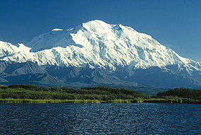
| 1 |
 Alaska Alaska |
Alaska Range Alaska Range The Alaska Range is a relatively narrow, 650-km-long mountain range in the southcentral region of the U.S. state of Alaska, from Lake Clark at its southwest end to the White River in Canada's Yukon Territory in the southeast... |
63.0690°N 151.0063°W |
| 2 |
Alaska Yukon Yukon |
Saint Elias Mountains Saint Elias Mountains The Saint Elias Mountains are a subgroup of the Pacific Coast Ranges, located in southeastern Alaska in the United States, southwestern Yukon and the very far northwestern part of British Columbia in Canada. The range spans Wrangell-St. Elias National Park and Preserve in the USA and Kluane... |
60.2927°N 140.9307°W |
| 3 |
Alaska |
Alaska Range Alaska Range The Alaska Range is a relatively narrow, 650-km-long mountain range in the southcentral region of the U.S. state of Alaska, from Lake Clark at its southwest end to the White River in Canada's Yukon Territory in the southeast... |
62.9605°N 151.3992°W |
| 4 |
Alaska |
Saint Elias Mountains Saint Elias Mountains The Saint Elias Mountains are a subgroup of the Pacific Coast Ranges, located in southeastern Alaska in the United States, southwestern Yukon and the very far northwestern part of British Columbia in Canada. The range spans Wrangell-St. Elias National Park and Preserve in the USA and Kluane... |
61.3845°N 141.7529°W |
| 5 |
Alaska |
Wrangell Mountains Wrangell Mountains The Wrangell Mountains are a high mountain range of eastern Alaska in the United States. Much of the range is included in Wrangell-Saint Elias National Park and Preserve. The Wrangell Mountains are almost entirely volcanic in origin, and they include the second and third highest volcanoes in the... |
61.7305°N 143.4031°W |
| 6 |
Alaska |
Wrangell Mountains Wrangell Mountains The Wrangell Mountains are a high mountain range of eastern Alaska in the United States. Much of the range is included in Wrangell-Saint Elias National Park and Preserve. The Wrangell Mountains are almost entirely volcanic in origin, and they include the second and third highest volcanoes in the... |
62.2132°N 144.1292°W |
| 7 |
Alaska British Columbia British Columbia |
Saint Elias Mountains Saint Elias Mountains The Saint Elias Mountains are a subgroup of the Pacific Coast Ranges, located in southeastern Alaska in the United States, southwestern Yukon and the very far northwestern part of British Columbia in Canada. The range spans Wrangell-St. Elias National Park and Preserve in the USA and Kluane... |
58.9064°N 137.5265°W |
| 8 |
Alaska Yukon |
Saint Elias Mountains Saint Elias Mountains The Saint Elias Mountains are a subgroup of the Pacific Coast Ranges, located in southeastern Alaska in the United States, southwestern Yukon and the very far northwestern part of British Columbia in Canada. The range spans Wrangell-St. Elias National Park and Preserve in the USA and Kluane... |
60.3194°N 139.0726°W |
| 9 |
Alaska |
Saint Elias Mountains Saint Elias Mountains The Saint Elias Mountains are a subgroup of the Pacific Coast Ranges, located in southeastern Alaska in the United States, southwestern Yukon and the very far northwestern part of British Columbia in Canada. The range spans Wrangell-St. Elias National Park and Preserve in the USA and Kluane... |
61.2834°N 141.1433°W |
| 10 |
Alaska |
Alaska Range Alaska Range The Alaska Range is a relatively narrow, 650-km-long mountain range in the southcentral region of the U.S. state of Alaska, from Lake Clark at its southwest end to the White River in Canada's Yukon Territory in the southeast... |
62.9496°N 151.0921°W |
| 11 |
 California California |
Sierra Nevada |
36.5786°N 118.2920°W |
| 12 |
Alaska Yukon |
Saint Elias Mountains Saint Elias Mountains The Saint Elias Mountains are a subgroup of the Pacific Coast Ranges, located in southeastern Alaska in the United States, southwestern Yukon and the very far northwestern part of British Columbia in Canada. The range spans Wrangell-St. Elias National Park and Preserve in the USA and Kluane... |
60.3519°N 139.0752°W |
| 13 |
Alaska |
Saint Elias Mountains Saint Elias Mountains The Saint Elias Mountains are a subgroup of the Pacific Coast Ranges, located in southeastern Alaska in the United States, southwestern Yukon and the very far northwestern part of British Columbia in Canada. The range spans Wrangell-St. Elias National Park and Preserve in the USA and Kluane... |
61.3272°N 141.7867°W |
| 14 |
 Colorado Colorado |
Sawatch Range Sawatch Range The Sawatch Range is a mountain range in central Colorado which includes eight of the twenty highest peaks in the Rocky Mountains, including Mount Elbert, at elevation, the highest peak in the Rockies.... |
39.1178°N 106.4454°W |
| 15 |
Colorado |
Sawatch Range Sawatch Range The Sawatch Range is a mountain range in central Colorado which includes eight of the twenty highest peaks in the Rocky Mountains, including Mount Elbert, at elevation, the highest peak in the Rockies.... |
39.1875°N 106.4757°W |
| 16 |
Colorado |
Collegiate Peaks Collegiate Peaks The Collegiate Peaks is a name given to a section of the Sawatch Range of the Rocky Mountains located in central Colorado. The Collegiate Peaks include some of the highest mountains in the Rockies... |
38.9244°N 106.3207°W |
| 17 |
 Washington Washington |
Cascade Range Cascade Range The Cascade Range is a major mountain range of western North America, extending from southern British Columbia through Washington and Oregon to Northern California. It includes both non-volcanic mountains, such as the North Cascades, and the notable volcanoes known as the High Cascades... |
46.8521°N 121.7579°W |
| 18 |
California |
Sierra Nevada |
36.6559°N 118.3111°W |
| 19 |
Colorado |
Collegiate Peaks Collegiate Peaks The Collegiate Peaks is a name given to a section of the Sawatch Range of the Rocky Mountains located in central Colorado. The Collegiate Peaks include some of the highest mountains in the Rockies... |
39.0294°N 106.4729°W |
| 20 |
Colorado |
Sangre de Cristo Range Sangre de Cristo Range The Sangre de Cristo Range, called the East Range locally in the San Luis Valley, is a narrow mountain range of the Rocky Mountains running north and south along the east side of the Rio Grande Rift in southern Colorado in the United States... |
37.5775°N 105.4857°W |
| 21 |
Colorado |
San Juan Mountains San Juan Mountains The San Juan Mountains are a high and rugged mountain range in the Rocky Mountains in southwestern Colorado. The area is highly mineralized and figured in the gold and silver mining industry of early Colorado. Major towns, all old mining camps, include Creede, Lake City, Silverton, Ouray, and... |
38.0717°N 107.4621°W |
| 22 |
Colorado |
Sangre de Cristo Range Sangre de Cristo Range The Sangre de Cristo Range, called the East Range locally in the San Luis Valley, is a narrow mountain range of the Rocky Mountains running north and south along the east side of the Rio Grande Rift in southern Colorado in the United States... |
37.9668°N 105.5855°W |
| 23 |
Colorado |
Mosquito Range Mosquito Range The Mosquito Range is a high mountain range in the Rocky Mountains of central Colorado in the United States. The peaks of the range form a ridge running north-south for approximately 40 miles from southern Summit County on the north end, then along the boundary between Lake and Park counties... |
39.3515°N 106.1116°W |
| 24 |
Colorado |
Elk Mountains Elk Mountains (Colorado) The Elk Mountains are a high, rugged mountain range in the Rocky Mountains of west-central Colorado in the United States. The mountains sit on the western side of the Continental Divide, largely in southern Pitkin and northern Gunnison counties, in the area southwest of Aspen, south of the Roaring... |
39.0097°N 106.8614°W |
| 25 |
Colorado |
Front Range Front Range The Front Range is a mountain range of the Southern Rocky Mountains of North America located in the north-central portion of the U.S. State of Colorado and southeastern portion of the U.S. State of Wyoming. It is the first mountain range encountered moving west along the 40th parallel north across... |
39.6339°N 105.8176°W |
| 26 |
Colorado |
Sawatch Range Sawatch Range The Sawatch Range is a mountain range in central Colorado which includes eight of the twenty highest peaks in the Rocky Mountains, including Mount Elbert, at elevation, the highest peak in the Rockies.... |
38.6741°N 106.2462°W |
| 27 |
Colorado |
Front Range Front Range The Front Range is a mountain range of the Southern Rocky Mountains of North America located in the north-central portion of the U.S. State of Colorado and southeastern portion of the U.S. State of Wyoming. It is the first mountain range encountered moving west along the 40th parallel north across... |
39.5883°N 105.6438°W |
| 28 |
Colorado |
Front Range Front Range The Front Range is a mountain range of the Southern Rocky Mountains of North America located in the north-central portion of the U.S. State of Colorado and southeastern portion of the U.S. State of Wyoming. It is the first mountain range encountered moving west along the 40th parallel north across... |
40.2550°N 105.6151°W |
| 29 |
Colorado |
San Miguel Mountains San Juan Mountains The San Juan Mountains are a high and rugged mountain range in the Rocky Mountains in southwestern Colorado. The area is highly mineralized and figured in the gold and silver mining industry of early Colorado. Major towns, all old mining camps, include Creede, Lake City, Silverton, Ouray, and... |
37.8391°N 107.9916°W |
| 30 |
California |
White Mountains White Mountains (California) The White Mountains of California are a triangular fault block mountain range facing the Sierra Nevada across the upper Owens Valley. They extend for approximately as a greatly elevated plateau about wide on the south, narrowing to a point at the north, with elevations generally increasing... |
37.6341°N 118.2557°W |
| 31 |
California |
Sierra Nevada |
37.0943°N 118.5147°W |
| 32 |
Colorado |
Collegiate Peaks Collegiate Peaks The Collegiate Peaks is a name given to a section of the Sawatch Range of the Rocky Mountains located in central Colorado. The Collegiate Peaks include some of the highest mountains in the Rockies... |
38.7492°N 106.2424°W |
| 33 |
Colorado |
Collegiate Peaks Collegiate Peaks The Collegiate Peaks is a name given to a section of the Sawatch Range of the Rocky Mountains located in central Colorado. The Collegiate Peaks include some of the highest mountains in the Rockies... |
38.8442°N 106.3138°W |
| 34 |
California |
Cascade Range Cascade Range The Cascade Range is a major mountain range of western North America, extending from southern British Columbia through Washington and Oregon to Northern California. It includes both non-volcanic mountains, such as the North Cascades, and the notable volcanoes known as the High Cascades... |
41.4092°N 122.1949°W |
| 35 |
Colorado |
Elk Mountains Elk Mountains (Colorado) The Elk Mountains are a high, rugged mountain range in the Rocky Mountains of west-central Colorado in the United States. The mountains sit on the western side of the Continental Divide, largely in southern Pitkin and northern Gunnison counties, in the area southwest of Aspen, south of the Roaring... |
39.0708°N 106.9890°W |
| 36 |
Alaska |
Wrangell Mountains Wrangell Mountains The Wrangell Mountains are a high mountain range of eastern Alaska in the United States. Much of the range is included in Wrangell-Saint Elias National Park and Preserve. The Wrangell Mountains are almost entirely volcanic in origin, and they include the second and third highest volcanoes in the... |
62.0059°N 144.0187°W |
| 37 |
Colorado |
Sneffels Range San Juan Mountains The San Juan Mountains are a high and rugged mountain range in the Rocky Mountains in southwestern Colorado. The area is highly mineralized and figured in the gold and silver mining industry of early Colorado. Major towns, all old mining camps, include Creede, Lake City, Silverton, Ouray, and... |
38.0038°N 107.7923°W |
| 38 |
Colorado |
Elk Mountains Elk Mountains (Colorado) The Elk Mountains are a high, rugged mountain range in the Rocky Mountains of west-central Colorado in the United States. The mountains sit on the western side of the Continental Divide, largely in southern Pitkin and northern Gunnison counties, in the area southwest of Aspen, south of the Roaring... |
39.1503°N 107.0829°W |
| 39 |
Colorado |
Pikes Peak Massif Pikes Peak Pikes Peak is a mountain in the Front Range of the Rocky Mountains, west of Colorado Springs, Colorado, in El Paso County in the United States of America.... |
38.8405°N 105.0442°W |
| 40 |
Colorado |
Needle Mountains Needle Mountains (Colorado) The Needle Mountains are a subrange of the San Juan Mountains of the Rocky Mountains located in the southwestern part of the U.S. State of Colorado. Much of the range is protected in the Weminuche Wilderness of the San Juan National Forest. The range is notable for having some of the most rugged... |
37.6218°N 107.6227°W |
| 41 |
Alaska Yukon |
Saint Elias Mountains Saint Elias Mountains The Saint Elias Mountains are a subgroup of the Pacific Coast Ranges, located in southeastern Alaska in the United States, southwestern Yukon and the very far northwestern part of British Columbia in Canada. The range spans Wrangell-St. Elias National Park and Preserve in the USA and Kluane... |
60.3074°N 140.4584°W |
| 42 |
Colorado |
San Juan Mountains San Juan Mountains The San Juan Mountains are a high and rugged mountain range in the Rocky Mountains in southwestern Colorado. The area is highly mineralized and figured in the gold and silver mining industry of early Colorado. Major towns, all old mining camps, include Creede, Lake City, Silverton, Ouray, and... |
37.9130°N 107.5044°W |
| 43 |
Colorado |
Culebra Range |
37.1224°N 105.1858°W |
| 44 |
Colorado |
La Garita Mountains La Garita Mountains During the Oligocene epoch, a series of caldera building eruptions of titanic proportions, some as large as VEI-8, devastated what is now Colorado and raised up the mountain chain, part of the San Juan Mountains. The La Garita supervolcano's mega-colossal eruption created 5000 km3 of tephra,... |
37.9868°N 106.9313°W |
| 45 |
Colorado |
Sawatch Range Sawatch Range The Sawatch Range is a mountain range in central Colorado which includes eight of the twenty highest peaks in the Rocky Mountains, including Mount Elbert, at elevation, the highest peak in the Rockies.... |
39.4668°N 106.4817°W |
| 46 |
Colorado |
Collegiate Peaks Collegiate Peaks The Collegiate Peaks is a name given to a section of the Sawatch Range of the Rocky Mountains located in central Colorado. The Collegiate Peaks include some of the highest mountains in the Rockies... |
39.0425°N 106.5976°W |
| 47 |
California |
Sierra Nevada |
37.2705°N 118.6730°W |
| 48 |
California |
Sierra Nevada |
36.7001°N 118.3436°W |
| 49 |
Colorado |
Sawatch Range Sawatch Range The Sawatch Range is a mountain range in central Colorado which includes eight of the twenty highest peaks in the Rocky Mountains, including Mount Elbert, at elevation, the highest peak in the Rockies.... |
38.4227°N 106.2247°W |
| 50 |
Colorado |
San Juan Mountains San Juan Mountains The San Juan Mountains are a high and rugged mountain range in the Rocky Mountains in southwestern Colorado. The area is highly mineralized and figured in the gold and silver mining industry of early Colorado. Major towns, all old mining camps, include Creede, Lake City, Silverton, Ouray, and... |
37.7993°N 107.8285°W |
Most prominent summits
The following sortable table lists the 50 most topographically prominentTopographic prominence
In topography, prominence, also known as autonomous height, relative height, shoulder drop , or prime factor , categorizes the height of the mountain's or hill's summit by the elevation between it and the lowest contour line encircling it and no higher summit...
mountain peaks
Summit (topography)
In topography, a summit is a point on a surface that is higher in elevation than all points immediately adjacent to it. Mathematically, a summit is a local maximum in elevation...
of the United States
United States
The United States of America is a federal constitutional republic comprising fifty states and a federal district...
. Of these 50 most prominent summits, 27 are located in Alaska
Alaska
Alaska is the largest state in the United States by area. It is situated in the northwest extremity of the North American continent, with Canada to the east, the Arctic Ocean to the north, and the Pacific Ocean to the west and south, with Russia further west across the Bering Strait...
, 5 in Washington, 5 in California
California
California is a state located on the West Coast of the United States. It is by far the most populous U.S. state, and the third-largest by land area...
, 3 in Hawaiʻi, 3 in Wyoming
Wyoming
Wyoming is a state in the mountain region of the Western United States. The western two thirds of the state is covered mostly with the mountain ranges and rangelands in the foothills of the Eastern Rocky Mountains, while the eastern third of the state is high elevation prairie known as the High...
, 2 in Nevada
Nevada
Nevada is a state in the western, mountain west, and southwestern regions of the United States. With an area of and a population of about 2.7 million, it is the 7th-largest and 35th-most populous state. Over two-thirds of Nevada's people live in the Las Vegas metropolitan area, which contains its...
, 2 in Oregon
Oregon
Oregon is a state in the Pacific Northwest region of the United States. It is located on the Pacific coast, with Washington to the north, California to the south, Nevada on the southeast and Idaho to the east. The Columbia and Snake rivers delineate much of Oregon's northern and eastern...
, and one each in Colorado
Colorado
Colorado is a U.S. state that encompasses much of the Rocky Mountains as well as the northeastern portion of the Colorado Plateau and the western edge of the Great Plains...
, Utah
Utah
Utah is a state in the Western United States. It was the 45th state to join the Union, on January 4, 1896. Approximately 80% of Utah's 2,763,885 people live along the Wasatch Front, centering on Salt Lake City. This leaves vast expanses of the state nearly uninhabited, making the population the...
, and Arizona
Arizona
Arizona ; is a state located in the southwestern region of the United States. It is also part of the western United States and the mountain west. The capital and largest city is Phoenix...
.
| Rank Ranking A ranking is a relationship between a set of items such that, for any two items, the first is either 'ranked higher than', 'ranked lower than' or 'ranked equal to' the second.... |
Mountain Peak Summit (topography) In topography, a summit is a point on a surface that is higher in elevation than all points immediately adjacent to it. Mathematically, a summit is a local maximum in elevation... |
State U.S. state A U.S. state is any one of the 50 federated states of the United States of America that share sovereignty with the federal government. Because of this shared sovereignty, an American is a citizen both of the federal entity and of his or her state of domicile. Four states use the official title of... |
Mountain Range Mountain range A mountain range is a single, large mass consisting of a succession of mountains or narrowly spaced mountain ridges, with or without peaks, closely related in position, direction, formation, and age; a component part of a mountain system or of a mountain chain... |
Elevation | Prominence Topographic prominence In topography, prominence, also known as autonomous height, relative height, shoulder drop , or prime factor , categorizes the height of the mountain's or hill's summit by the elevation between it and the lowest contour line encircling it and no higher summit... |
Isolation Topographic isolation The topographic isolation of a summit is the minimum horizontal distance to the nearest point of higher elevation. Topographic isolation represents a radius of dominance in which the summit is the highest point. Topographic isolation can be calculated for small hills and islands as well as for... |
Location Geographic coordinate system A geographic coordinate system is a coordinate system that enables every location on the Earth to be specified by a set of numbers. The coordinates are often chosen such that one of the numbers represent vertical position, and two or three of the numbers represent horizontal position... |
|---|---|---|---|
| 1 |
Alaska |
Alaska Range Alaska Range The Alaska Range is a relatively narrow, 650-km-long mountain range in the southcentral region of the U.S. state of Alaska, from Lake Clark at its southwest end to the White River in Canada's Yukon Territory in the southeast... |
63.0690°N 151.0063°W |
| 2 |
 Hawaii Hawaii |
Island of Hawaii Hawaii (island) The Island of Hawaii, also called the Big Island or Hawaii Island , is a volcanic island in the North Pacific Ocean... |
19.8207°N 155.4681°W |
| 3 |
Washington |
Cascade Range Cascade Range The Cascade Range is a major mountain range of western North America, extending from southern British Columbia through Washington and Oregon to Northern California. It includes both non-volcanic mountains, such as the North Cascades, and the notable volcanoes known as the High Cascades... |
46.8521°N 121.7579°W |
| 4 |
Alaska British Columbia |
Saint Elias Mountains Saint Elias Mountains The Saint Elias Mountains are a subgroup of the Pacific Coast Ranges, located in southeastern Alaska in the United States, southwestern Yukon and the very far northwestern part of British Columbia in Canada. The range spans Wrangell-St. Elias National Park and Preserve in the USA and Kluane... |
58.9064°N 137.5265°W |
| 5 |
Alaska |
Wrangell Mountains Wrangell Mountains The Wrangell Mountains are a high mountain range of eastern Alaska in the United States. Much of the range is included in Wrangell-Saint Elias National Park and Preserve. The Wrangell Mountains are almost entirely volcanic in origin, and they include the second and third highest volcanoes in the... |
61.7305°N 143.4031°W |
| 6 |
Alaska |
Alaska Range Alaska Range The Alaska Range is a relatively narrow, 650-km-long mountain range in the southcentral region of the U.S. state of Alaska, from Lake Clark at its southwest end to the White River in Canada's Yukon Territory in the southeast... |
63.6199°N 146.7174°W |
| 7 |
Alaska Yukon |
Saint Elias Mountains Saint Elias Mountains The Saint Elias Mountains are a subgroup of the Pacific Coast Ranges, located in southeastern Alaska in the United States, southwestern Yukon and the very far northwestern part of British Columbia in Canada. The range spans Wrangell-St. Elias National Park and Preserve in the USA and Kluane... |
60.2927°N 140.9307°W |
| 8 |
Alaska |
Chugach Mountains Chugach Mountains The Chugach Mountains of southern Alaska are the northernmost of the several mountain ranges that make up the Pacific Coast Ranges of the western edge of North America. The range is about 500 km long, running generally east-west. Its highest point is Mount Marcus Baker, at , but most of its... |
61.4374°N 147.7525°W |
| 9 |
California |
Sierra Nevada |
36.5786°N 118.2920°W |
| 10 |
Hawaii |
Island of Maui Maui The island of Maui is the second-largest of the Hawaiian Islands at and is the 17th largest island in the United States. Maui is part of the state of Hawaii and is the largest of Maui County's four islands, bigger than Lānai, Kahoolawe, and Molokai. In 2010, Maui had a population of 144,444,... |
20.7097°N 156.2533°W |
| 11 |
California |
Cascade Range Cascade Range The Cascade Range is a major mountain range of western North America, extending from southern British Columbia through Washington and Oregon to Northern California. It includes both non-volcanic mountains, such as the North Cascades, and the notable volcanoes known as the High Cascades... |
41.4092°N 122.1949°W |
| 12 |
Alaska |
Unimak Island Unimak Island Unimak Island is the largest island in the Aleutian Islands chain of the U.S. state of Alaska. It is the easternmost island in the Aleutians and, with an area of 1,571.41 mi² , the ninth largest island in the United States and the 134th largest island in the world. It is home to Mount... |
54.7554°N 163.9709°W |
| 13 |
Alaska |
Aleutian Range Aleutian Range The Aleutian Range is a major mountain range of southwest Alaska, extending from Chakachamna Lake to Unimak Island, at the tip of the Alaska Peninsula. It includes all of the mountains of the Peninsula. It is especially notable for its large number of active volcanoes, which are also part of the... |
60.4851°N 152.7439°W |
| 14 |
Colorado |
Sawatch Range Sawatch Range The Sawatch Range is a mountain range in central Colorado which includes eight of the twenty highest peaks in the Rocky Mountains, including Mount Elbert, at elevation, the highest peak in the Rockies.... |
39.1178°N 106.4454°W |
| 15 |
Washington |
Cascade Range Cascade Range The Cascade Range is a major mountain range of western North America, extending from southern British Columbia through Washington and Oregon to Northern California. It includes both non-volcanic mountains, such as the North Cascades, and the notable volcanoes known as the High Cascades... |
48.7768°N 121.8145°W |
| 16 |
Alaska |
Alaska Range Alaska Range The Alaska Range is a relatively narrow, 650-km-long mountain range in the southcentral region of the U.S. state of Alaska, from Lake Clark at its southwest end to the White River in Canada's Yukon Territory in the southeast... |
61.4086°N 152.4125°W |
| 17 |
California |
San Jacinto Mountains San Jacinto Mountains The San Jacinto Mountains are a mountain range east of Los Angeles in southern California in the United States. The mountains are named for Saint Hyacinth . The Pacific Crest Trail runs along the spine of the range.The range extends for approximately from the San Bernardino Mountains southeast to... |
33.8147°N 116.6794°W |
| 18 |
California |
San Bernardino Mountains San Bernardino Mountains The San Bernardino Mountains are a short transverse mountain range north and east of San Bernardino in Southern California in the United States. The mountains run for approximately 60 miles east-west on the southern edge of the Mojave Desert in southwestern San Bernardino County, north of the... |
34.0992°N 116.8249°W |
| 19 |
 Nevada Nevada |
Spring Mountains Spring Mountains The Spring Mountains are a mountain range of southern Nevada in the United States, running generally northwest-southeast along the west side of Las Vegas and down to the border with California... |
36.2716°N 115.6956°W |
| 20 |
Alaska |
Aleutian Range Aleutian Range The Aleutian Range is a major mountain range of southwest Alaska, extending from Chakachamna Lake to Unimak Island, at the tip of the Alaska Peninsula. It includes all of the mountains of the Peninsula. It is especially notable for its large number of active volcanoes, which are also part of the... |
55.4175°N 161.8932°W |
| 21 |
Alaska |
Aleutian Range Aleutian Range The Aleutian Range is a major mountain range of southwest Alaska, extending from Chakachamna Lake to Unimak Island, at the tip of the Alaska Peninsula. It includes all of the mountains of the Peninsula. It is especially notable for its large number of active volcanoes, which are also part of the... |
56.2191°N 159.2980°W |
| 22 |
Washington |
Cascade Range Cascade Range The Cascade Range is a major mountain range of western North America, extending from southern British Columbia through Washington and Oregon to Northern California. It includes both non-volcanic mountains, such as the North Cascades, and the notable volcanoes known as the High Cascades... |
46.2024°N 121.4909°W |
| 23 |
Alaska Yukon |
Saint Elias Mountains Saint Elias Mountains The Saint Elias Mountains are a subgroup of the Pacific Coast Ranges, located in southeastern Alaska in the United States, southwestern Yukon and the very far northwestern part of British Columbia in Canada. The range spans Wrangell-St. Elias National Park and Preserve in the USA and Kluane... |
60.3194°N 139.0726°W |
| 24 |
Alaska |
Brooks Range Brooks Range The Brooks Range is a mountain range in far northern North America. It stretches from west to east across northern Alaska and into Canada's Yukon Territory, a total distance of about 1100 km . The mountains top out at over 2,700 m . The range is believed to be approximately 126 million years old... |
69.2820°N 144.8996°W |
| 25 |
Alaska |
Aleutian Range Aleutian Range The Aleutian Range is a major mountain range of southwest Alaska, extending from Chakachamna Lake to Unimak Island, at the tip of the Alaska Peninsula. It includes all of the mountains of the Peninsula. It is especially notable for its large number of active volcanoes, which are also part of the... |
60.0321°N 153.0915°W |
| 26 |
Washington |
Olympic Mountains Olympic Mountains The Olympic Mountains is a mountain range on the Olympic Peninsula of western Washington in the United States. The mountains, part of the Pacific Coast Ranges, are not especially high - Mount Olympus is the highest at - but the western slopes of the Olympics rise directly out of the Pacific... |
47.8013°N 123.7108°W |
| 27 |
Alaska Yukon |
Saint Elias Mountains Saint Elias Mountains The Saint Elias Mountains are a subgroup of the Pacific Coast Ranges, located in southeastern Alaska in the United States, southwestern Yukon and the very far northwestern part of British Columbia in Canada. The range spans Wrangell-St. Elias National Park and Preserve in the USA and Kluane... |
60.1816°N 139.9811°W |
| 28 |
 Oregon Oregon |
Cascade Range Cascade Range The Cascade Range is a major mountain range of western North America, extending from southern British Columbia through Washington and Oregon to Northern California. It includes both non-volcanic mountains, such as the North Cascades, and the notable volcanoes known as the High Cascades... |
45.3735°N 121.6959°W |
| 29 |
Alaska |
Wrangell Mountains Wrangell Mountains The Wrangell Mountains are a high mountain range of eastern Alaska in the United States. Much of the range is included in Wrangell-Saint Elias National Park and Preserve. The Wrangell Mountains are almost entirely volcanic in origin, and they include the second and third highest volcanoes in the... |
62.2132°N 144.1292°W |
| 30 |
Alaska |
Chugach Mountains Chugach Mountains The Chugach Mountains of southern Alaska are the northernmost of the several mountain ranges that make up the Pacific Coast Ranges of the western edge of North America. The range is about 500 km long, running generally east-west. Its highest point is Mount Marcus Baker, at , but most of its... |
60.6512°N 143.6970°W |
| 31 |
Nevada |
Snake Range Snake Range The Snake Range is a line of high mountains in eastern White Pine County, in east-central Nevada in the western United States. Typical of other ranges in the Basin and Range Province, it runs in a north-south direction, in this case for approximately... |
38.9858°N 114.3139°W |
| 32 |
Washington |
Cascade Range Cascade Range The Cascade Range is a major mountain range of western North America, extending from southern British Columbia through Washington and Oregon to Northern California. It includes both non-volcanic mountains, such as the North Cascades, and the notable volcanoes known as the High Cascades... |
48.1125°N 121.1138°W |
| 33 |
Alaska |
Alaska Range Alaska Range The Alaska Range is a relatively narrow, 650-km-long mountain range in the southcentral region of the U.S. state of Alaska, from Lake Clark at its southwest end to the White River in Canada's Yukon Territory in the southeast... |
63.2390°N 144.6419°W |
| 34 |
Alaska |
Aleutian Range Aleutian Range The Aleutian Range is a major mountain range of southwest Alaska, extending from Chakachamna Lake to Unimak Island, at the tip of the Alaska Peninsula. It includes all of the mountains of the Peninsula. It is especially notable for its large number of active volcanoes, which are also part of the... |
58.3534°N 155.0958°W |
| 35 |
Alaska |
Alaska Range Alaska Range The Alaska Range is a relatively narrow, 650-km-long mountain range in the southcentral region of the U.S. state of Alaska, from Lake Clark at its southwest end to the White River in Canada's Yukon Territory in the southeast... |
62.9605°N 151.3992°W |
| 36 |
California |
White Mountains White Mountains (California) The White Mountains of California are a triangular fault block mountain range facing the Sierra Nevada across the upper Owens Valley. They extend for approximately as a greatly elevated plateau about wide on the south, narrowing to a point at the north, with elevations generally increasing... |
37.6341°N 118.2557°W |
| 37 |
Alaska |
Saint Elias Mountains Saint Elias Mountains The Saint Elias Mountains are a subgroup of the Pacific Coast Ranges, located in southeastern Alaska in the United States, southwestern Yukon and the very far northwestern part of British Columbia in Canada. The range spans Wrangell-St. Elias National Park and Preserve in the USA and Kluane... |
58.6625°N 137.1716°W |
| 38 |
Hawaii |
Island of Hawaii Hawaii (island) The Island of Hawaii, also called the Big Island or Hawaii Island , is a volcanic island in the North Pacific Ocean... |
19.4747°N 155.6058°W |
| 39 |
 Wyoming Wyoming |
Bighorn Mountains |
44.3821°N 107.1739°W |
| 40 |
Wyoming |
Wind River Range Wind River Range The Wind River Range , is a mountain range of the Rocky Mountains in western Wyoming in the United States. The range runs roughly NW-SE for approximately 100 miles . The Continental Divide follows the crest of the range and includes Gannett Peak, which at 13,804 feet , is the highest peak... |
43.1842°N 109.6542°W |
| 41 |
Alaska |
Umnak Island Umnak Umnak is one of the Fox Islands of the Aleutian Islands. With of land area, it is the third largest island in the Aleutian archipelago and the 19th largest island in the United States. The island is home to a large volcanic caldera on Mount Okmok and is separated from Unalaska Island by Umnak Pass... |
53.1251°N 168.6947°W |
| 42 |
Alaska |
Alaska Range Alaska Range The Alaska Range is a relatively narrow, 650-km-long mountain range in the southcentral region of the U.S. state of Alaska, from Lake Clark at its southwest end to the White River in Canada's Yukon Territory in the southeast... |
61.8036°N 154.1469°W |
| 43 |
Alaska |
Saint Elias Mountains Saint Elias Mountains The Saint Elias Mountains are a subgroup of the Pacific Coast Ranges, located in southeastern Alaska in the United States, southwestern Yukon and the very far northwestern part of British Columbia in Canada. The range spans Wrangell-St. Elias National Park and Preserve in the USA and Kluane... |
61.3845°N 141.7529°W |
| 44 |
Alaska |
Wrangell Mountains Wrangell Mountains The Wrangell Mountains are a high mountain range of eastern Alaska in the United States. Much of the range is included in Wrangell-Saint Elias National Park and Preserve. The Wrangell Mountains are almost entirely volcanic in origin, and they include the second and third highest volcanoes in the... |
62.1159°N 144.6394°W |
| 45 |
Alaska |
Aleutian Range Aleutian Range The Aleutian Range is a major mountain range of southwest Alaska, extending from Chakachamna Lake to Unimak Island, at the tip of the Alaska Peninsula. It includes all of the mountains of the Peninsula. It is especially notable for its large number of active volcanoes, which are also part of the... |
57.1312°N 156.9836°W |
| 46 |
Wyoming |
Teton Range Teton Range The Teton Range is a mountain range of the Rocky Mountains in North America. A north-south range, it is on the Wyoming side of the state's border with Idaho, just south of Yellowstone National Park. Most of the range is in Grand Teton National Park.... |
43.7412°N 110.8024°W |
| 47 |
Oregon |
Wallowa Mountains Wallowa Mountains The Wallowa Mountains are a mountain range located in the Columbia Plateau of northeastern Oregon in the United States. The range runs approximately 40 mi northwest to southeast in southwestern Wallowa County between the Blue Mountains to the west and the Snake River to the east. The range is... |
45.2450°N 117.2929°W |
| 48 |
Alaska |
Aleutian Range Aleutian Range The Aleutian Range is a major mountain range of southwest Alaska, extending from Chakachamna Lake to Unimak Island, at the tip of the Alaska Peninsula. It includes all of the mountains of the Peninsula. It is especially notable for its large number of active volcanoes, which are also part of the... |
60.7981°N 153.3959°W |
| 49 |
 Utah Utah |
Uinta Mountains Uinta Mountains The Uinta Mountains are a high chain of mountains in northeastern Utah and extreme northwestern Colorado in the United States. A subrange of the Rocky Mountains, they are unusual for being the highest range in the contiguous United States running east to west, and lie approximately east of Salt... |
40.7659°N 110.3779°W |
| 50 |
 Arizona Arizona |
Pinaleño Mountains Pinaleno Mountains The Pinaleño Mountains, or the Pinal Mountains, are a remote mountain range in southeastern Arizona. They have over of vertical relief, more than any other range in the state. The mountains are surrounded by the Sonoran-Chihuahuan Desert. Subalpine forests cover the higher elevations... |
32.7017°N 109.8714°W |
Most isolated major summits
The following sortable table lists the 50 most topographically isolatedTopographic isolation
The topographic isolation of a summit is the minimum horizontal distance to the nearest point of higher elevation. Topographic isolation represents a radius of dominance in which the summit is the highest point. Topographic isolation can be calculated for small hills and islands as well as for...
mountain peaks
Summit (topography)
In topography, a summit is a point on a surface that is higher in elevation than all points immediately adjacent to it. Mathematically, a summit is a local maximum in elevation...
of the United States
United States
The United States of America is a federal constitutional republic comprising fifty states and a federal district...
with at least 500 meters (1640.4 feet) of topographic prominence
Topographic prominence
In topography, prominence, also known as autonomous height, relative height, shoulder drop , or prime factor , categorizes the height of the mountain's or hill's summit by the elevation between it and the lowest contour line encircling it and no higher summit...
. Of these 50 most isolated major summits, 19 are located in Alaska
Alaska
Alaska is the largest state in the United States by area. It is situated in the northwest extremity of the North American continent, with Canada to the east, the Arctic Ocean to the north, and the Pacific Ocean to the west and south, with Russia further west across the Bering Strait...
, 4 in California
California
California is a state located on the West Coast of the United States. It is by far the most populous U.S. state, and the third-largest by land area...
, 3 in Washington, 2 in Hawaiʻi, 2 in Colorado
Colorado
Colorado is a U.S. state that encompasses much of the Rocky Mountains as well as the northeastern portion of the Colorado Plateau and the western edge of the Great Plains...
, 2 in Wyoming
Wyoming
Wyoming is a state in the mountain region of the Western United States. The western two thirds of the state is covered mostly with the mountain ranges and rangelands in the foothills of the Eastern Rocky Mountains, while the eastern third of the state is high elevation prairie known as the High...
, 2 in Arizona
Arizona
Arizona ; is a state located in the southwestern region of the United States. It is also part of the western United States and the mountain west. The capital and largest city is Phoenix...
, 2 in Nevada
Nevada
Nevada is a state in the western, mountain west, and southwestern regions of the United States. With an area of and a population of about 2.7 million, it is the 7th-largest and 35th-most populous state. Over two-thirds of Nevada's people live in the Las Vegas metropolitan area, which contains its...
, 2 in Utah
Utah
Utah is a state in the Western United States. It was the 45th state to join the Union, on January 4, 1896. Approximately 80% of Utah's 2,763,885 people live along the Wasatch Front, centering on Salt Lake City. This leaves vast expanses of the state nearly uninhabited, making the population the...
, 2 in New York
New York
New York is a state in the Northeastern region of the United States. It is the nation's third most populous state. New York is bordered by New Jersey and Pennsylvania to the south, and by Connecticut, Massachusetts and Vermont to the east...
, 2 in Oregon
Oregon
Oregon is a state in the Pacific Northwest region of the United States. It is located on the Pacific coast, with Washington to the north, California to the south, Nevada on the southeast and Idaho to the east. The Columbia and Snake rivers delineate much of Oregon's northern and eastern...
, and one each in North Carolina
North Carolina
North Carolina is a state located in the southeastern United States. The state borders South Carolina and Georgia to the south, Tennessee to the west and Virginia to the north. North Carolina contains 100 counties. Its capital is Raleigh, and its largest city is Charlotte...
, New Hampshire
New Hampshire
New Hampshire is a state in the New England region of the northeastern United States of America. The state was named after the southern English county of Hampshire. It is bordered by Massachusetts to the south, Vermont to the west, Maine and the Atlantic Ocean to the east, and the Canadian...
, Arkansas
Arkansas
Arkansas is a state located in the southern region of the United States. Its name is an Algonquian name of the Quapaw Indians. Arkansas shares borders with six states , and its eastern border is largely defined by the Mississippi River...
, West Virginia
West Virginia
West Virginia is a state in the Appalachian and Southeastern regions of the United States, bordered by Virginia to the southeast, Kentucky to the southwest, Ohio to the northwest, Pennsylvania to the northeast and Maryland to the east...
, New Mexico
New Mexico
New Mexico is a state located in the southwest and western regions of the United States. New Mexico is also usually considered one of the Mountain States. With a population density of 16 per square mile, New Mexico is the sixth-most sparsely inhabited U.S...
, Maine
Maine
Maine is a state in the New England region of the northeastern United States, bordered by the Atlantic Ocean to the east and south, New Hampshire to the west, and the Canadian provinces of Quebec to the northwest and New Brunswick to the northeast. Maine is both the northernmost and easternmost...
, Idaho
Idaho
Idaho is a state in the Rocky Mountain area of the United States. The state's largest city and capital is Boise. Residents are called "Idahoans". Idaho was admitted to the Union on July 3, 1890, as the 43rd state....
, and South Dakota
South Dakota
South Dakota is a state located in the Midwestern region of the United States. It is named after the Lakota and Dakota Sioux American Indian tribes. Once a part of Dakota Territory, South Dakota became a state on November 2, 1889. The state has an area of and an estimated population of just over...
.
| Rank Ranking A ranking is a relationship between a set of items such that, for any two items, the first is either 'ranked higher than', 'ranked lower than' or 'ranked equal to' the second.... |
Mountain Peak Summit (topography) In topography, a summit is a point on a surface that is higher in elevation than all points immediately adjacent to it. Mathematically, a summit is a local maximum in elevation... |
State U.S. state A U.S. state is any one of the 50 federated states of the United States of America that share sovereignty with the federal government. Because of this shared sovereignty, an American is a citizen both of the federal entity and of his or her state of domicile. Four states use the official title of... |
Mountain Range Mountain range A mountain range is a single, large mass consisting of a succession of mountains or narrowly spaced mountain ridges, with or without peaks, closely related in position, direction, formation, and age; a component part of a mountain system or of a mountain chain... |
Elevation | Prominence Topographic prominence In topography, prominence, also known as autonomous height, relative height, shoulder drop , or prime factor , categorizes the height of the mountain's or hill's summit by the elevation between it and the lowest contour line encircling it and no higher summit... |
Isolation Topographic isolation The topographic isolation of a summit is the minimum horizontal distance to the nearest point of higher elevation. Topographic isolation represents a radius of dominance in which the summit is the highest point. Topographic isolation can be calculated for small hills and islands as well as for... |
Location Geographic coordinate system A geographic coordinate system is a coordinate system that enables every location on the Earth to be specified by a set of numbers. The coordinates are often chosen such that one of the numbers represent vertical position, and two or three of the numbers represent horizontal position... |
|---|---|---|---|
| 1 |
Alaska |
Alaska Range Alaska Range The Alaska Range is a relatively narrow, 650-km-long mountain range in the southcentral region of the U.S. state of Alaska, from Lake Clark at its southwest end to the White River in Canada's Yukon Territory in the southeast... |
63.0690°N 151.0063°W |
| 2 |
Hawaii |
Island of Hawaii Hawaii (island) The Island of Hawaii, also called the Big Island or Hawaii Island , is a volcanic island in the North Pacific Ocean... |
19.8207°N 155.4681°W |
| 3 |
California |
Sierra Nevada |
36.5786°N 118.2920°W |
| 4 |
 North Carolina North Carolina |
Blue Ridge Mountains Blue Ridge Mountains The Blue Ridge Mountains are a physiographic province of the larger Appalachian Mountains range. This province consists of northern and southern physiographic regions, which divide near the Roanoke River gap. The mountain range is located in the eastern United States, starting at its southern-most... |
35.7650°N 82.2652°W |
| 5 |
 New Hampshire New Hampshire |
White Mountains White Mountains (New Hampshire) The White Mountains are a mountain range covering about a quarter of the state of New Hampshire and a small portion of western Maine in the United States. Part of the Appalachian Mountains, they are considered the most rugged mountains in New England... |
44.2705°N 71.3032°W |
| 6 |
Washington |
Cascade Range Cascade Range The Cascade Range is a major mountain range of western North America, extending from southern British Columbia through Washington and Oregon to Northern California. It includes both non-volcanic mountains, such as the North Cascades, and the notable volcanoes known as the High Cascades... |
46.8521°N 121.7579°W |
| 7 |
Colorado |
Sawatch Range Sawatch Range The Sawatch Range is a mountain range in central Colorado which includes eight of the twenty highest peaks in the Rocky Mountains, including Mount Elbert, at elevation, the highest peak in the Rockies.... |
39.1178°N 106.4454°W |
| 8 |
Alaska |
Unimak Island Unimak Island Unimak Island is the largest island in the Aleutian Islands chain of the U.S. state of Alaska. It is the easternmost island in the Aleutians and, with an area of 1,571.41 mi² , the ninth largest island in the United States and the 134th largest island in the world. It is home to Mount... |
54.7554°N 163.9709°W |
| 9 |
Alaska |
Tanaga Island Tanaga Island Tanaga Island is an island in the western Andreanof Islands, in the southwest part of the Aleutian Islands, Alaska. The island has a land area of , making it the 33rd largest island in the United States. Its highest point is volcano Mount Tanaga at .... |
51.8833°N 178.1333°W |
| 10 |
Alaska |
Brooks Range Brooks Range The Brooks Range is a mountain range in far northern North America. It stretches from west to east across northern Alaska and into Canada's Yukon Territory, a total distance of about 1100 km . The mountains top out at over 2,700 m . The range is believed to be approximately 126 million years old... |
69.2820°N 144.8996°W |
| 11 |
 Arkansas Arkansas |
Ouachita Mountains Ouachita Mountains The Ouachita Mountains are a mountain range in west central Arkansas and southeastern Oklahoma. The range's subterranean roots may extend as far as central Texas, or beyond it to the current location of the Marathon Uplift. Along with the Ozark Mountains, the Ouachita Mountains form the U.S... |
35.1670°N 93.6447°W |
| 12 |
California |
Cascade Range Cascade Range The Cascade Range is a major mountain range of western North America, extending from southern British Columbia through Washington and Oregon to Northern California. It includes both non-volcanic mountains, such as the North Cascades, and the notable volcanoes known as the High Cascades... |
41.4092°N 122.1949°W |
| 13 |
Wyoming |
Wind River Range Wind River Range The Wind River Range , is a mountain range of the Rocky Mountains in western Wyoming in the United States. The range runs roughly NW-SE for approximately 100 miles . The Continental Divide follows the crest of the range and includes Gannett Peak, which at 13,804 feet , is the highest peak... |
43.1842°N 109.6542°W |
| 14 |
Alaska |
Seward Peninsula Seward Peninsula The Seward Peninsula is a large peninsula on the western coast of the U.S. state of Alaska. It projects about into the Bering Sea between Norton Sound, the Bering Strait, the Chukchi Sea, and Kotzebue Sound, just below the Arctic Circle... |
64.9922°N 165.3294°W |
| 15 |
Alaska |
Brooks Range Brooks Range The Brooks Range is a mountain range in far northern North America. It stretches from west to east across northern Alaska and into Canada's Yukon Territory, a total distance of about 1100 km . The mountains top out at over 2,700 m . The range is believed to be approximately 126 million years old... |
67.4129°N 154.9656°W |
| 16 |
Arizona |
San Francisco Peaks San Francisco Peaks The San Francisco Peaks are a volcanic mountain range located in north central Arizona, just north of Flagstaff.The highest summit in the range, Humphreys Peak, is the highest point in the state of Arizona at in elevation. The San Francisco Peaks are the remains of an eroded stratovolcano... |
35.3463°N 111.6779°W |
| 17 |
Nevada |
Snake Range Snake Range The Snake Range is a line of high mountains in eastern White Pine County, in east-central Nevada in the western United States. Typical of other ranges in the Basin and Range Province, it runs in a north-south direction, in this case for approximately... |
38.9858°N 114.3139°W |
| 18 |
Alaska |
Umnak Island Umnak Umnak is one of the Fox Islands of the Aleutian Islands. With of land area, it is the third largest island in the Aleutian archipelago and the 19th largest island in the United States. The island is home to a large volcanic caldera on Mount Okmok and is separated from Unalaska Island by Umnak Pass... |
53.1251°N 168.6947°W |
| 19 |
Alaska |
Aleutian Range Aleutian Range The Aleutian Range is a major mountain range of southwest Alaska, extending from Chakachamna Lake to Unimak Island, at the tip of the Alaska Peninsula. It includes all of the mountains of the Peninsula. It is especially notable for its large number of active volcanoes, which are also part of the... |
56.2191°N 159.2980°W |
| 20 |
Hawaii |
Island of Kauai Kauai Kauai or Kauai, known as Tauai in the ancient Kaua'i dialect, is geologically the oldest of the main Hawaiian Islands. With an area of , it is the fourth largest of the main islands in the Hawaiian archipelago, and the 21st largest island in the United States. Known also as the "Garden Isle",... |
22.0586°N 159.4973°W |
| 21 |
Alaska |
Kuskokwim Mountains Kuskokwim Mountains The Kuskokwim Mountains is a range of mountains in the Yukon-Koyukuk Census Area, Alaska, United States, west of the Alaska Range and southeast of the Yukon River, at about . The Kuskokwim Mountains begin in the interior west of Fairbanks... |
60.1159°N 159.3241°W |
| 22 |
Alaska |
Hall Island Hall Island (Alaska) Hall Island is a small island located to the northwest of St. Matthew Island in the Bering Sea in Alaska, USA. It serves as a haulout site for Pacific walrus. It is in length and has a land area of . The highest point is . Hall Island is uninhabited. It is part of the Bering Sea unit of the... |
60.6647°N 173.0887°W |
| 23 |
Alaska |
Saint Lawrence Island |
63.5920°N 170.3804°W |
| 24 |
 West Virginia West Virginia |
Allegheny Mountains Allegheny Mountains The Allegheny Mountain Range , also spelled Alleghany, Allegany and, informally, the Alleghenies, is part of the vast Appalachian Mountain Range of the eastern United States and Canada... |
38.7008°N 79.5319°W |
| 25 |
Alaska |
Nunivak Island Nunivak Island Nunivak Island , the second largest island in the Bering Sea, is a permafrost-covered volcanic island lying about 30 miles offshore from the delta of the Yukon and Kuskokwim rivers in the state of Alaska, at about 60° North latitude... |
60.0280°N 166.2627°W |
| 26 |
Utah |
Uinta Mountains Uinta Mountains The Uinta Mountains are a high chain of mountains in northeastern Utah and extreme northwestern Colorado in the United States. A subrange of the Rocky Mountains, they are unusual for being the highest range in the contiguous United States running east to west, and lie approximately east of Salt... |
40.7659°N 110.3779°W |
| 27 |
 New Mexico New Mexico |
Sierra Blanca |
33.3743°N 105.8087°W |
| 28 |
California |
San Bernardino Mountains San Bernardino Mountains The San Bernardino Mountains are a short transverse mountain range north and east of San Bernardino in Southern California in the United States. The mountains run for approximately 60 miles east-west on the southern edge of the Mojave Desert in southwestern San Bernardino County, north of the... |
34.0992°N 116.8249°W |
| 29 |
 Maine Maine |
Longfellow Mountains Longfellow Mountains In 1959, the Maine Legislature voted to give the various mountains and ranges in Maine the collective name of the Longfellow Mountains, in honor of the Maine-born poet Henry Wadsworth Longfellow . Despite its official status, the term has very little currency... |
45.9044°N 68.9213°W |
| 30 |
Alaska |
Nulato Hills |
64.4535°N 159.4152°W |
| 31 |
Arizona |
White Mountains White Mountains (Arizona) The White Mountains of Arizona are a mountain range and mountainous region in the eastern part of the state, near the border with New Mexico; it is a continuation from the west of the Arizona transition zone–Mogollon Rim, with the Rim ending in western New Mexico... |
33.9059°N 109.5626°W |
| 32 |
 Idaho Idaho |
Lost River Range Lost River Range The Lost River Range is a group of high mountains located in central Idaho, in the northwestern United States. It runs southeast for approximately 75 miles from the Salmon River near the community of Challis to the Snake River Valley near Arco... |
44.1374°N 113.7811°W |
| 33 |
Wyoming |
Bighorn Mountains |
44.3821°N 107.1739°W |
| 34 |
 South Dakota South Dakota |
Black Hills Black Hills The Black Hills are a small, isolated mountain range rising from the Great Plains of North America in western South Dakota and extending into Wyoming, USA. Set off from the main body of the Rocky Mountains, the region is something of a geological anomaly—accurately described as an "island of... |
43.8658°N 103.5324°W |
| 35 |
 New York New York |
Catskill Mountains Catskill Mountains The Catskill Mountains, an area in New York State northwest of New York City and southwest of Albany, are a mature dissected plateau, an uplifted region that was subsequently eroded into sharp relief. They are an eastward continuation, and the highest representation, of the Allegheny Plateau... |
41.9992°N 74.3859°W |
| 36 |
Alaska |
Aleutian Range Aleutian Range The Aleutian Range is a major mountain range of southwest Alaska, extending from Chakachamna Lake to Unimak Island, at the tip of the Alaska Peninsula. It includes all of the mountains of the Peninsula. It is especially notable for its large number of active volcanoes, which are also part of the... |
58.3534°N 155.0958°W |
| 37 |
Nevada |
Spring Mountains Spring Mountains The Spring Mountains are a mountain range of southern Nevada in the United States, running generally northwest-southeast along the west side of Las Vegas and down to the border with California... |
36.2716°N 115.6956°W |
| 38 |
California |
Santa Lucia Range |
36.1456°N 121.4190°W |
| 39 |
Washington |
Cascade Range Cascade Range The Cascade Range is a major mountain range of western North America, extending from southern British Columbia through Washington and Oregon to Northern California. It includes both non-volcanic mountains, such as the North Cascades, and the notable volcanoes known as the High Cascades... |
48.7768°N 121.8145°W |
| 40 |
New York |
Adirondack Mountains Adirondack Mountains The Adirondack Mountains are a mountain range located in the northeastern part of New York, that runs through Clinton, Essex, Franklin, Fulton, Hamilton, Herkimer, Lewis, Saint Lawrence, Saratoga, Warren, and Washington counties.... |
44.1127°N 73.9237°W |
| 41 |
Alaska |
Alaska Range Alaska Range The Alaska Range is a relatively narrow, 650-km-long mountain range in the southcentral region of the U.S. state of Alaska, from Lake Clark at its southwest end to the White River in Canada's Yukon Territory in the southeast... |
63.6199°N 146.7174°W |
| 42 |
Alaska |
Chugach Mountains Chugach Mountains The Chugach Mountains of southern Alaska are the northernmost of the several mountain ranges that make up the Pacific Coast Ranges of the western edge of North America. The range is about 500 km long, running generally east-west. Its highest point is Mount Marcus Baker, at , but most of its... |
61.4374°N 147.7525°W |
| 43 |
Oregon |
Wallowa Mountains Wallowa Mountains The Wallowa Mountains are a mountain range located in the Columbia Plateau of northeastern Oregon in the United States. The range runs approximately 40 mi northwest to southeast in southwestern Wallowa County between the Blue Mountains to the west and the Snake River to the east. The range is... |
45.2450°N 117.2929°W |
| 44 |
Oregon |
Steens Mountain Steens Mountain Steens Mountain is a large fault-block mountain in the southeastern part of the U.S. state of Oregon. Located in Harney County, it stretches some and rises from an elevation of about above the Alvord Desert to its peak at... |
42.6378°N 118.5785°W |
| 45 |
Alaska British Columbia |
Saint Elias Mountains Saint Elias Mountains The Saint Elias Mountains are a subgroup of the Pacific Coast Ranges, located in southeastern Alaska in the United States, southwestern Yukon and the very far northwestern part of British Columbia in Canada. The range spans Wrangell-St. Elias National Park and Preserve in the USA and Kluane... |
58.9064°N 137.5265°W |
| 46 |
Utah |
Tushar Mountains Tushar Mountains The Tushar Mountains are the third highest mountain range in Utah after the Uinta Mountains and the La Sal Range. Located in the Fishlake National Forest, Delano Peak, 12,174 ft NAVD 88, is the highest point in both Beaver and Piute counties and has a prominence of 4,689 ft... |
38.3692°N 112.3714°W |
| 47 |
Alaska |
Brooks Range Brooks Range The Brooks Range is a mountain range in far northern North America. It stretches from west to east across northern Alaska and into Canada's Yukon Territory, a total distance of about 1100 km . The mountains top out at over 2,700 m . The range is believed to be approximately 126 million years old... |
68.5598°N 160.3281°W |
| 48 |
Alaska |
Ray Mountains Ray Mountains The Ray Mountains is a mountain range in central Alaska named for the Ray River, itself named for U.S. Navy Captain Patrick Henry Ray, who established a meteorological station in Barrow, Alaska in 1881. The mountains are located within the Yukon-Tanana Uplands, an area of low mountain ranges that... |
65.6863°N 150.9496°W |
| 49 |
Washington |
Olympic Mountains Olympic Mountains The Olympic Mountains is a mountain range on the Olympic Peninsula of western Washington in the United States. The mountains, part of the Pacific Coast Ranges, are not especially high - Mount Olympus is the highest at - but the western slopes of the Olympics rise directly out of the Pacific... |
47.8013°N 123.7108°W |
| 50 |
Colorado |
Sangre de Cristo Range Sangre de Cristo Range The Sangre de Cristo Range, called the East Range locally in the San Luis Valley, is a narrow mountain range of the Rocky Mountains running north and south along the east side of the Rio Grande Rift in southern Colorado in the United States... |
37.5775°N 105.4857°W |
See also
- Lists of mountains
- Mountain peaks of North AmericaMountain peaks of North AmericaThis article comprises three sortable tables of major mountain peaks of greater North America.This article defines greater North America as the portion of the continental landmass of the Americas extending northward from Panama plus the islands surrounding that landmass...
- Mountain peaks of GreenlandMountain peaks of GreenlandThis article comprises three sortable tables of major mountain peaks of Greenland. For this article, Greenland includes all of Kalaallit Nunaat including the Island of Greenland and surrounding islands....
- Mountain peaks of CanadaMountain peaks of CanadaThis article comprises three sortable tables of major mountain peaks of Canada.Topographic elevation is the vertical distance above the reference geoid, a precise mathematical model of the Earth's sea level as an equipotential gravitational surface. Topographic prominence is the elevation...
- Mountain peaks of the Rocky MountainsMountain peaks of the Rocky MountainsThis article comprises three sortable tables of major mountain peaks of the Rocky Mountains of North America.Topographic elevation is the vertical distance above the reference geoid, a precise mathematical model of the Earth's sea level as an equipotential gravitational surface...
- Mountain peaks of the United States
- Table of the highest major summits of the United States
- Table of the most prominent summits of the United StatesTable of the most prominent summits of the United StatesThe following sortable table lists the 180 most topographically prominent mountain peaks of the United States.Topographic elevation is the vertical distance above the reference geoid, a precise mathematical model of the Earth's sea level as an equipotential gravitational surface...
- Table of the most isolated major summits of the United States
- Mountain peaks of AlaskaMountain peaks of AlaskaThis article comprises three sortable tables of mountain peaks of the U.S. State of Alaska.Topographic elevation is the vertical distance above the reference geoid, a precise mathematical model of the Earth's sea level as an equipotential gravitational surface. Topographic prominence is the...
- Mountain peaks of CaliforniaMountain peaks of CaliforniaThis article comprises three sortable tables of major mountain peaks of the U.S. State of California.Topographic elevation is the vertical distance above the reference geoid, a precise mathematical model of the Earth's sea level as an equipotential gravitational surface...
- Mountain peaks of ColoradoMountain peaks of ColoradoThis article comprises three sortable tables of the major mountain peaks of the U.S. State of Colorado.Topographic elevation is the vertical distance above the reference geoid, a precise mathematical model of the Earth's sea level as an equipotential gravitational surface...
- Mountain peaks of MéxicoMountain peaks of MexicoThis article comprises three sortable tables of the major mountain peaks of Mexico.Topographic elevation is the vertical distance above the reference geoid, a precise mathematical model of the Earth's sea level as an equipotential gravitational surface. Topographic prominence is the elevation...
- Mountain peaks of Central AmericaMountain peaks of Central AmericaThis article comprises three sortable tables of major mountain peaks of Central America. This article defines Central America as the seven nations of Belize, Costa Rica, El Salvador, Guatemala, Honduras, Nicaragua, and Panama....
- Mountain peaks of the CaribbeanMountain peaks of the CaribbeanThis article comprises three sortable tables of major mountain peaks of the islands of the Caribbean Sea.Topographic elevation is the vertical distance above the reference geoid, a precise mathematical model of the Earth's sea level as an equipotential gravitational surface...
- Mountain peaks of Greenland
- Physical geographyPhysical geographyPhysical geography is one of the two major subfields of geography. Physical geography is that branch of natural science which deals with the study of processes and patterns in the natural environment like the atmosphere, biosphere and geosphere, as opposed to the cultural or built environment, the...
- TopographyTopographyTopography is the study of Earth's surface shape and features or those ofplanets, moons, and asteroids...
- Topographic elevation
- Topographic isolationTopographic isolationThe topographic isolation of a summit is the minimum horizontal distance to the nearest point of higher elevation. Topographic isolation represents a radius of dominance in which the summit is the highest point. Topographic isolation can be calculated for small hills and islands as well as for...
- Topographic prominenceTopographic prominenceIn topography, prominence, also known as autonomous height, relative height, shoulder drop , or prime factor , categorizes the height of the mountain's or hill's summit by the elevation between it and the lowest contour line encircling it and no higher summit...
- Topographic summit
- Topography
- United States of America
- Geography of the United StatesGeography of the United StatesThe United States is a country in the Western Hemisphere. It consists of forty-eight contiguous states in North America, Alaska, a peninsula which forms the northwestern most part of North America, and Hawaii, an archipelago in the Pacific Ocean. There are several United States territories in the...
- :Category:Mountains of the United States
- commons:Category:Mountains of the United States
- :Category:Mountains of the United States
- Geography of the United States