
Pinaleno Mountains
Encyclopedia
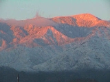
The Pinaleño Mountains, or the Pinal Mountains, are a remote mountain range in southeastern Arizona
. They have over 7000 feet (2,133.6 m) of vertical relief, more than any other range in the state. The mountains are surrounded by the Sonoran
-Chihuahuan Desert
. Subalpine forests cover the higher elevations. According to The Nature Conservancy
, they traverse five ecological communities and contain "the highest diversity of habitats of any mountain range in North America." The highest point is Mount Graham
at 10720 feet (3,267 m). Locals often refer to the whole mountain range as "Mount Graham", in which case the peak is referred to as "High Peak". The mountains cover 300 mi2 and are part of the Coronado National Forest
, Safford ranger district.
The mountains are a Madrean
sky island
range that is typical of southern Arizona, specifically south-central Arizona, and especially the complete southeastern quadrant of Arizona, from Tucson, and Globe
to Nogales
, Douglas
, and the Chiricahua
s. Sky island ranges are mountains isolated by desert valleys. The deserts, as well as differences in elevation, prevent flora and fauna from traveling to or from nearby ecosystems. As a result, the mountain ecosystems are isolated, and distinct sub-species can develop. This is similar to what Charles Darwin
discovered with species he collected from different islands in the Galápagos
, a discovery that played a major role in his theory of natural selection
. The Mount Graham red squirrel
is an isolated population of red squirrels and possibly a sub-species as well.
Safford
and Willcox, Arizona are the nearest towns to the Pinaleños.
, quaking aspen, Ponderosa pine
, silverleaf oaks (south-facing slopes), box elder
, and bigtooth maple
. Frequently seen animals include mule deer
, Coue's white tail deer, hawks, and black bear
. For a comprehensive list of the flora and fauna of these biodiverse mountains see the University of Arizona's Mount Graham Biology Program.
Laboratory have discovered living trees that date back to 1257 and 1270 AD. Botanists say the Douglas firs have survived because the rocky cliffs of the mountains have served as a fire barrier for them. The scientists also found dead firs that dated as far back as 1102 AD."
station. "During General Nelson Miles’ mid-1880’s campaign against the Apaches led by Geronimo, a U.S. Signal Corps officer named Colonel William A. Glassford established an innovative signal system. Atop mountain peaks throughout southeastern Arizona and southwestern New Mexico, soldiers manned stations using mirrors, or heliographs, to flash messages across great distances. Heliograph Peak, as one of the highest mountains in southeast Arizona, served as one of the peaks in that system. Miles cornered Geronimo in 1886 and had him sent into exile in Florida. As a reward for their efforts, the Apache scouts that had helped defeat Geronimo were sent into exile along with him. Shortly thereafter, the heliograph system was abandoned along with a number of forts used in the Apache campaign."
(CCC) completed many projects in the 1930s. "Men from all over the country came to the area to work in numerous camps, several located on Mount Graham." Treasure Park and Columbine were used during the summer months, and Arcadia, Noon Creek and other sites were used during the winter months. "Many of the improvements at campgrounds, as well as hiking trails, roads and other facilities now enjoyed by many visitors to Mount Graham, were built by the CCC personnel."
One of their projects included the construction of a 99 feet (30.2 m) steel framed lookout tower on Heliograph Peak to watch for fires in the Pinaleños and nearby mountain ranges including the Galiuro
s, Dos Cabezas, White Mountains
, Gila
s, Rincon
s and Santa Catalinas
. The tower still stands as of 2006, however, most fire watching efforts in Arizona are conducted from the ground or by airplane.
 In the summer of 2004 the Nuttall-Gibson complex burned over 30,000 acres (120 km²) in the Pinaleños. Monsoon rains helped firefighters in their efforts. The firefighting cost over $8.5 million and engaged over 800 firefighters. "Crews were able to prevent the fire from damaging the Mount Graham International Observatory
and the cabins. There were only two structures damaged by the fires. A historic fire lookout was partially burned, and an electronic equipment storage shack was damaged Tuesday when the Gibson fire hit Heliograph
Peak."
Arizona's Governor Janet Napolitano
visited the area at the time of the fire. "This is a big, major fire, and it concerns us all," she said. Regarding her aerial tour, the governor said, "The fire looks a lot better today than it did a week ago. I flew over Mount Graham on July 4 and all I could see was smoke. Now, I can clearly see the perimeters the firefighters have been burning." Napolitano provided for inmate wildland fire crews to provide fire suppression and forest thinning services.
mountain range, they are by definition unique. The U.S. Forest Services claims that "prior to about 1870, the Pinaleños maintained healthy, resilient ecosystems that were adapted to naturally occurring fire regimes (primarily frequent, low-intensity wildfires)." They go on to explain that "After European settlement, the natural ecosystem processes were interrupted by passive (overgrazing) and active fire suppression, and harvest of large-diameter trees. The result is that today the forests are composed of overly dense, small-diameter trees and snags with excessive amounts of downed wood. The composition of the mixed-conifer forest between about 8,500 and 10000 feet (3,048 m) elevation has shifted from fire-adapted to fire-intolerant tree species."
primarily maintained by the University of Arizona
. The observatory is home to some of the most sophisticated astronomical instruments
and telescopes in the world.
(LBT) will peer deeper into space than ever before, and with ten times the clarity of the Hubble Space Telescope
. With unparalleled observational capability, astronomers will be able to view planets in distant solar systems, and detect and measure objects dating back to the beginning of time (14 billion years ago). The LBT is already partially operational.
in 1988. There were two sources of controversy related to the observatory.
First, some Native Americans
, consider the site to be sacred
. They argued that it was unacceptable to deface the sacred mountains with an observatory.
Second, some environmentalists worried that construction of the site would adversely affect the endangered
population of the Mount Graham Red Squirrel
. The Mount Graham subspecies was thought to have been extinct in the 1950s, but small numbers of squirrels were "rediscovered" in the 1970s. The squirrel was added to the federal endangered species list in 1987 by the U.S. Fish and Wildlife Service, when the estimated population in 1986 was fewer than 400. The Mount Graham subspecies has been isolated from other subspecies of red squirrels since the end of the Pleistocene
glacial periods. It is still rather unclear if the Mt. Graham red squirrel is distinct or not from red squirrels elsewhere. Studies on genetic data are in progress.
Astronomers and other personnel working at the site have faced protests, threats of physical violence, and attempts at sabotage on the mountain. As a result of this conflict, a "squirrel permit" must be obtained by anyone visiting the observatory at a facility towards the base of the mountain.
10,720 feet (3,267 m) Some sources say Mount Graham is 10713 feet (3,265.3 m) high.
2. Hawk Peak 10,627 feet (3,239 m)
3. Plain View Peak 10,370 feet (3,161 m)
4. Heliograph Peak 10,022 feet (3,056 m)
5. Merrill Peak 9,288 feet (2,831 m)
6. Ladybug Peak 8,780 feet (2,676 m)
7. Greasewood Mountain 7,094 feet (2,162 m)
Arizona
Arizona ; is a state located in the southwestern region of the United States. It is also part of the western United States and the mountain west. The capital and largest city is Phoenix...
. They have over 7000 feet (2,133.6 m) of vertical relief, more than any other range in the state. The mountains are surrounded by the Sonoran
Sonoran Desert
The Sonoran Desert is a North American desert which straddles part of the United States-Mexico border and covers large parts of the U.S. states of Arizona and California and the northwest Mexican states of Sonora, Baja California, and Baja California Sur. It is one of the largest and hottest...
-Chihuahuan Desert
Chihuahuan Desert
The Chihuahuan Desert is a desert, and an ecoregion designation, that straddles the U.S.-Mexico border in the central and northern portions of the Mexican Plateau, bordered on the west by the extensive Sierra Madre Occidental range, and overlaying northern portions of the east range, the Sierra...
. Subalpine forests cover the higher elevations. According to The Nature Conservancy
The Nature Conservancy
The Nature Conservancy is a US charitable environmental organization that works to preserve the plants, animals, and natural communities that represent the diversity of life on Earth by protecting the lands and waters they need to survive....
, they traverse five ecological communities and contain "the highest diversity of habitats of any mountain range in North America." The highest point is Mount Graham
Mount Graham
Mount Graham is a mountain in southeastern Arizona in the United States, in the Coronado National Forest. It is the highest mountain in the Pinaleño Mountains. As the name "Mount Graham" is often used by locals to refer to the entire mountain range, the peak itself is frequently referred to as...
at 10720 feet (3,267 m). Locals often refer to the whole mountain range as "Mount Graham", in which case the peak is referred to as "High Peak". The mountains cover 300 mi2 and are part of the Coronado National Forest
Coronado National Forest
The Coronado National Forest includes an area of about 1.78 million acres spread throughout mountain ranges in southeastern Arizona and southwestern New Mexico....
, Safford ranger district.
The mountains are a Madrean
Madrean sky islands
The Madrean Sky Islands are enclaves of Madrean pine-oak woodlands, found at higher elevations in a complex of small mountain ranges in southern and southeastern Arizona, southwestern New Mexico, and northwestern Mexico. The sky islands are surrounded at lower elevations by the Sonoran and...
sky island
Sky island
Sky islands are mountains that are isolated by surrounding lowlands of a dramatically different environment, a situation which, in combination with the altitudinal zonation of ecosystems, has significant implications for natural habitats. Endemism, vertical migration, and relict populations are...
range that is typical of southern Arizona, specifically south-central Arizona, and especially the complete southeastern quadrant of Arizona, from Tucson, and Globe
Globe, Arizona
Globe has an arid climate, characterized by hot summers and moderate to warm winters. Globe's arid climate is somewhat tempered by its elevation, however, leading to slightly cooler temperatures and slightly more precipitation than Phoenix or Yuma....
to Nogales
Nogales, Arizona
Nogales is a city in Santa Cruz County, Arizona, United States. The population was 21,017 at the 2010 census. According to 2005 Census Bureau estimates, the population of the city is 20,833. The city is the county seat of Santa Cruz County....
, Douglas
Douglas, Arizona
Douglas is a city in Cochise County, Arizona, United States. Douglas has a border crossing with Mexico and a history of mining.The population was 14,312 at the 2000 census...
, and the Chiricahua
Chiricahua Mountains
The Chiricahua Mountains are a mountain range in southeastern Arizona which are part of the Basin and Range province of the southwest, and part of the Coronado National Forest...
s. Sky island ranges are mountains isolated by desert valleys. The deserts, as well as differences in elevation, prevent flora and fauna from traveling to or from nearby ecosystems. As a result, the mountain ecosystems are isolated, and distinct sub-species can develop. This is similar to what Charles Darwin
Charles Darwin
Charles Robert Darwin FRS was an English naturalist. He established that all species of life have descended over time from common ancestry, and proposed the scientific theory that this branching pattern of evolution resulted from a process that he called natural selection.He published his theory...
discovered with species he collected from different islands in the Galápagos
Galápagos Islands
The Galápagos Islands are an archipelago of volcanic islands distributed around the equator in the Pacific Ocean, west of continental Ecuador, of which they are a part.The Galápagos Islands and its surrounding waters form an Ecuadorian province, a national park, and a...
, a discovery that played a major role in his theory of natural selection
Natural selection
Natural selection is the nonrandom process by which biologic traits become either more or less common in a population as a function of differential reproduction of their bearers. It is a key mechanism of evolution....
. The Mount Graham red squirrel
Mount Graham Red Squirrel
The Mount Graham Red Squirrel is an endangered subspecies of the American Red Squirrel native to the Pinaleño Mountains of Arizona. It is smaller than most other subspecies of Red Squirrel, and also does not have the white-fringed tail that is common to the species...
is an isolated population of red squirrels and possibly a sub-species as well.
Safford
Safford, Arizona
- History :Safford was founded by Joshua Eaton Bailey, Hiram Kennedy and Edward Tuttle, who came from Gila Bend, in southwestern Arizona. They left Gila Bend in the winter of 1873-74; their work on canals and dams having been destroyed by high water the previous summer...
and Willcox, Arizona are the nearest towns to the Pinaleños.
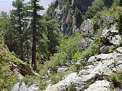
Flora and fauna
The diversity of the flora and fauna in the Pinaleños make them an especially notable range. Trees that grow there include: Douglas fir, Engelmann spruceEngelmann Spruce
Picea engelmannii is a species of spruce native to western North America, from central British Columbia and southwest Alberta, southwest to northern California and southeast to Arizona and New Mexico; there are also two isolated populations in northern Mexico...
, quaking aspen, Ponderosa pine
Ponderosa Pine
Pinus ponderosa, commonly known as the Ponderosa Pine, Bull Pine, Blackjack Pine, or Western Yellow Pine, is a widespread and variable pine native to western North America. It was first described by David Douglas in 1826, from eastern Washington near present-day Spokane...
, silverleaf oaks (south-facing slopes), box elder
Box Elder
Box Elder may refer to:*The Box elder, Acer negundo, a species of maple*The Box elder bug, an insect which feeds on maple trees*Box Elders, a punk band from Omaha, Nebraska*Places named "Box Elder" include:*Box Elder, Montana, United States of America...
, and bigtooth maple
Bigtooth Maple
Acer grandidentatum is a species of maple native to interior western North America, occurring in scattered populations from western Montana in the United States south to Coahuila in northern Mexico. It is closely related to Acer saccharum , and is treated as a subspecies of it by some botanists,...
. Frequently seen animals include mule deer
Mule Deer
The mule deer is a deer indigenous to western North America. The Mule Deer gets its name from its large mule-like ears. There are believed to be several subspecies, including the black-tailed deer...
, Coue's white tail deer, hawks, and black bear
American black bear
The American black bear is a medium-sized bear native to North America. It is the continent's smallest and most common bear species. Black bears are omnivores, with their diets varying greatly depending on season and location. They typically live in largely forested areas, but do leave forests in...
. For a comprehensive list of the flora and fauna of these biodiverse mountains see the University of Arizona's Mount Graham Biology Program.
Pre-Columbian flora
Unlike many of the other mountains in the area, the Pinaleños have no lava deposits. The lava-based mountains found throughout Arizona tend to be barren, whereas the Pinaleños (and others) have a large number of trees, including many that pre-date Columbus's arrival in the Americas. "Researchers from the University of Arizona Tree RingDendrochronology
Dendrochronology or tree-ring dating is the scientific method of dating based on the analysis of patterns of tree-rings. Dendrochronology can date the time at which tree rings were formed, in many types of wood, to the exact calendar year...
Laboratory have discovered living trees that date back to 1257 and 1270 AD. Botanists say the Douglas firs have survived because the rocky cliffs of the mountains have served as a fire barrier for them. The scientists also found dead firs that dated as far back as 1102 AD."
Heliograph station
Heliograph Peak was home to a nineteenth century heliographHeliograph
A heliograph is a wireless solar telegraph that signals by flashes of sunlight reflected by a mirror. The flashes are produced by momentarily pivoting the mirror, or by interrupting the beam with a shutter...
station. "During General Nelson Miles’ mid-1880’s campaign against the Apaches led by Geronimo, a U.S. Signal Corps officer named Colonel William A. Glassford established an innovative signal system. Atop mountain peaks throughout southeastern Arizona and southwestern New Mexico, soldiers manned stations using mirrors, or heliographs, to flash messages across great distances. Heliograph Peak, as one of the highest mountains in southeast Arizona, served as one of the peaks in that system. Miles cornered Geronimo in 1886 and had him sent into exile in Florida. As a reward for their efforts, the Apache scouts that had helped defeat Geronimo were sent into exile along with him. Shortly thereafter, the heliograph system was abandoned along with a number of forts used in the Apache campaign."
CCC
The Civilian Conservation CorpsCivilian Conservation Corps
The Civilian Conservation Corps was a public work relief program that operated from 1933 to 1942 in the United States for unemployed, unmarried men from relief families, ages 18–25. A part of the New Deal of President Franklin D...
(CCC) completed many projects in the 1930s. "Men from all over the country came to the area to work in numerous camps, several located on Mount Graham." Treasure Park and Columbine were used during the summer months, and Arcadia, Noon Creek and other sites were used during the winter months. "Many of the improvements at campgrounds, as well as hiking trails, roads and other facilities now enjoyed by many visitors to Mount Graham, were built by the CCC personnel."
One of their projects included the construction of a 99 feet (30.2 m) steel framed lookout tower on Heliograph Peak to watch for fires in the Pinaleños and nearby mountain ranges including the Galiuro
Galiuro Mountains
The Galiuro Mountains are a large sky island mountain range of southeast Arizona, USA. It is a northerly mountain range in the Madrean Sky Islands region of southeast Arizona, northern Sonora, Northern Mexico, and extreme southwest, bootheel New Mexico....
s, Dos Cabezas, White Mountains
White Mountains (Arizona)
The White Mountains of Arizona are a mountain range and mountainous region in the eastern part of the state, near the border with New Mexico; it is a continuation from the west of the Arizona transition zone–Mogollon Rim, with the Rim ending in western New Mexico...
, Gila
Gila Mountains (Graham County)
The Gila Mountains is a mountain range in central-east Arizona. It borders the Gila River and Gila Valley on the valley's northeast in north-central Graham County; also the San Carlos Indian Reservation...
s, Rincon
Rincon Mountains
The Rincon Mountains are a significant mountain range east of Tucson, Pima County, Arizona, in the United States. The Rincon Mountains are one of five mountain ranges surrounding the Tucson valley...
s and Santa Catalinas
Santa Catalina Mountains
The Santa Catalina Mountains, commonly referred to as the Catalina Mountains, are located north, and northeast of Tucson, Arizona, United States, on Tucson's north perimeter. The mountain range is the most prominent in the Tucson area, with the highest average elevation...
. The tower still stands as of 2006, however, most fire watching efforts in Arizona are conducted from the ground or by airplane.
2004 fire
Mount Graham International Observatory
Mount Graham International Observatory is a division of Steward Observatory the research arm for the Department of Astronomy at The University of Arizona. It is located in southeast Arizona's Pinaleno Mountains near Mount Graham....
and the cabins. There were only two structures damaged by the fires. A historic fire lookout was partially burned, and an electronic equipment storage shack was damaged Tuesday when the Gibson fire hit Heliograph
Heliograph
A heliograph is a wireless solar telegraph that signals by flashes of sunlight reflected by a mirror. The flashes are produced by momentarily pivoting the mirror, or by interrupting the beam with a shutter...
Peak."
Arizona's Governor Janet Napolitano
Janet Napolitano
Janet Napolitano is the third and current United States Secretary of Homeland Security, serving in the administration of President Barack Obama. She is the fourth person to hold the position, which was created after the 9/11 terrorist attacks. A member of the Democratic Party, she was the 21st...
visited the area at the time of the fire. "This is a big, major fire, and it concerns us all," she said. Regarding her aerial tour, the governor said, "The fire looks a lot better today than it did a week ago. I flew over Mount Graham on July 4 and all I could see was smoke. Now, I can clearly see the perimeters the firefighters have been burning." Napolitano provided for inmate wildland fire crews to provide fire suppression and forest thinning services.
Fragile ecosystem
Because the Pinaleños are a sky islandSky island
Sky islands are mountains that are isolated by surrounding lowlands of a dramatically different environment, a situation which, in combination with the altitudinal zonation of ecosystems, has significant implications for natural habitats. Endemism, vertical migration, and relict populations are...
mountain range, they are by definition unique. The U.S. Forest Services claims that "prior to about 1870, the Pinaleños maintained healthy, resilient ecosystems that were adapted to naturally occurring fire regimes (primarily frequent, low-intensity wildfires)." They go on to explain that "After European settlement, the natural ecosystem processes were interrupted by passive (overgrazing) and active fire suppression, and harvest of large-diameter trees. The result is that today the forests are composed of overly dense, small-diameter trees and snags with excessive amounts of downed wood. The composition of the mixed-conifer forest between about 8,500 and 10000 feet (3,048 m) elevation has shifted from fire-adapted to fire-intolerant tree species."
Potential threats from global climate change
Because they are a fragile eco-system, even small climate changes can have a profound effect. With potentially larger climate changes underway, the ecology of the Pinaleños could be threatened. This is the interpretation of the Forest Service. In particular some view the fires of 2004 as an event possibly driven in part by global warming. The agency states that "global climate change and drought are helping to poise the Pinaleños for epidemic insect or disease outbreaks and catastrophic, stand-replacing fires. Indeed, both of these events have taken place in recent years. The flora and fauna have not evolved to tolerate these new conditions or catastrophic events, so there is a need to use silvicultural management and prescribed burning to begin to restore the natural balance in the remaining forests and woodlands."Mount Graham Observatory
Sitting atop the highest mountain in the Pinaleños is Mount Graham International Observatory (MGIO), a division of the Steward ObservatorySteward Observatory
The University of Arizona's Steward Observatorys main office is located on the University's campus and is closely tied to the Department of Astronomy. Established in 1916 by its first director, Andrew Ellicott Douglass, and a $60,000 bequest made by Lavinia Steward in memory of her late husband...
primarily maintained by the University of Arizona
University of Arizona
The University of Arizona is a land-grant and space-grant public institution of higher education and research located in Tucson, Arizona, United States. The University of Arizona was the first university in the state of Arizona, founded in 1885...
. The observatory is home to some of the most sophisticated astronomical instruments
Astronomy
Astronomy is a natural science that deals with the study of celestial objects and phenomena that originate outside the atmosphere of Earth...
and telescopes in the world.
Home of world's most advanced telescope
Upon completion (fall 2006) the Large Binocular TelescopeLarge Binocular Telescope
Large Binocular Telescope is an optical telescope for astronomy located on Mount Graham in the Pinaleno Mountains of southeastern Arizona, and is a part of the Mount Graham International Observatory...
(LBT) will peer deeper into space than ever before, and with ten times the clarity of the Hubble Space Telescope
Hubble Space Telescope
The Hubble Space Telescope is a space telescope that was carried into orbit by a Space Shuttle in 1990 and remains in operation. A 2.4 meter aperture telescope in low Earth orbit, Hubble's four main instruments observe in the near ultraviolet, visible, and near infrared...
. With unparalleled observational capability, astronomers will be able to view planets in distant solar systems, and detect and measure objects dating back to the beginning of time (14 billion years ago). The LBT is already partially operational.
Controversy
Construction of the observatory was authorized by the United States CongressUnited States Congress
The United States Congress is the bicameral legislature of the federal government of the United States, consisting of the Senate and the House of Representatives. The Congress meets in the United States Capitol in Washington, D.C....
in 1988. There were two sources of controversy related to the observatory.
First, some Native Americans
Native Americans in the United States
Native Americans in the United States are the indigenous peoples in North America within the boundaries of the present-day continental United States, parts of Alaska, and the island state of Hawaii. They are composed of numerous, distinct tribes, states, and ethnic groups, many of which survive as...
, consider the site to be sacred
Sacred
Holiness, or sanctity, is in general the state of being holy or sacred...
. They argued that it was unacceptable to deface the sacred mountains with an observatory.
Second, some environmentalists worried that construction of the site would adversely affect the endangered
Endangered species
An endangered species is a population of organisms which is at risk of becoming extinct because it is either few in numbers, or threatened by changing environmental or predation parameters...
population of the Mount Graham Red Squirrel
Mount Graham Red Squirrel
The Mount Graham Red Squirrel is an endangered subspecies of the American Red Squirrel native to the Pinaleño Mountains of Arizona. It is smaller than most other subspecies of Red Squirrel, and also does not have the white-fringed tail that is common to the species...
. The Mount Graham subspecies was thought to have been extinct in the 1950s, but small numbers of squirrels were "rediscovered" in the 1970s. The squirrel was added to the federal endangered species list in 1987 by the U.S. Fish and Wildlife Service, when the estimated population in 1986 was fewer than 400. The Mount Graham subspecies has been isolated from other subspecies of red squirrels since the end of the Pleistocene
Pleistocene
The Pleistocene is the epoch from 2,588,000 to 11,700 years BP that spans the world's recent period of repeated glaciations. The name pleistocene is derived from the Greek and ....
glacial periods. It is still rather unclear if the Mt. Graham red squirrel is distinct or not from red squirrels elsewhere. Studies on genetic data are in progress.
Astronomers and other personnel working at the site have faced protests, threats of physical violence, and attempts at sabotage on the mountain. As a result of this conflict, a "squirrel permit" must be obtained by anyone visiting the observatory at a facility towards the base of the mountain.
The Swift trail
The Swift Trail (Arizona Route 366) is a modern highway making the Pinaleños very accessible. The road is 36 miles (57.9 km) long with 23 paved miles plus 13 miles (20.9 km) of graded dirt. In the course of an afternoon you can experience climate zones you would see in a drive from Mexico to Canada. This switchbacking mountain road was named for T. T. Swift, the first supervisor of the Coronado National Forest. Initially just a trail, the route has been improved many times. Two notable eras of improvent came in the 1930s and the 1990s. The Arizona Department of Transportation celebrated the latest improvements on June 30, 1992.Peaks of the Pinaleños
1. Mount GrahamMount Graham
Mount Graham is a mountain in southeastern Arizona in the United States, in the Coronado National Forest. It is the highest mountain in the Pinaleño Mountains. As the name "Mount Graham" is often used by locals to refer to the entire mountain range, the peak itself is frequently referred to as...
10,720 feet (3,267 m) Some sources say Mount Graham is 10713 feet (3,265.3 m) high.
2. Hawk Peak 10,627 feet (3,239 m)
3. Plain View Peak 10,370 feet (3,161 m)
4. Heliograph Peak 10,022 feet (3,056 m)
5. Merrill Peak 9,288 feet (2,831 m)
6. Ladybug Peak 8,780 feet (2,676 m)
7. Greasewood Mountain 7,094 feet (2,162 m)