
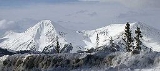
Sawatch Range
Encyclopedia
The Sawatch Range is a mountain range
in central Colorado
which includes eight of the twenty highest peaks in the Rocky Mountains
, including Mount Elbert
, at 14440 feet (4,401 m) elevation, the highest peak in the Rockies.
The range is oriented along a northwest-southeast axis, extending approximately 70 miles (112.7 km) from 39°37′36"N 106°32′13"W in the north to 38°33′19"N 106°17′32"W in the south. The range contains 15 peaks topping 14000 feet (4,267.2 m). The range forms a portion of the Continental Divide
, and its eastern flanks are drained by the headwaters of the Arkansas River
. The western side of the range feeds the headwaters of the Roaring Fork River
, the Eagle River
, and the Gunnison River
.
The Sawatch mountains in general are high, massive, and relatively gentle in contour. While some peaks are rugged enough to require technical climbing, most can be climbed by a simple, if arduous, hike. Notable summits include Mount Elbert
, Mount Massive
, La Plata Peak
, Mount of the Holy Cross
, and the Collegiate Peaks (Mounts Columbia
, Harvard
, Princeton
, and Yale
).
The town of Leadville, Colorado
is located about 10 miles (16.1 km) to the east. State Highway 82
traverses the range at Independence Pass
, which is typically open only from late spring to mid autumn. It is also traversed by Hagerman Pass
to the north, connecting the Arkansas Headwaters near Leadville with the upper valley of the Fryingpan River
. Hagerman pass is traversable with four-wheel drive
vehicles and on foot during summer and early autumn months. The range contains numerous hiking trails within the White River National Forest
and the Hunter-Fryingpan Wilderness
.
Mountain range
A mountain range is a single, large mass consisting of a succession of mountains or narrowly spaced mountain ridges, with or without peaks, closely related in position, direction, formation, and age; a component part of a mountain system or of a mountain chain...
in central Colorado
Colorado
Colorado is a U.S. state that encompasses much of the Rocky Mountains as well as the northeastern portion of the Colorado Plateau and the western edge of the Great Plains...
which includes eight of the twenty highest peaks in the Rocky Mountains
Rocky Mountains
The Rocky Mountains are a major mountain range in western North America. The Rocky Mountains stretch more than from the northernmost part of British Columbia, in western Canada, to New Mexico, in the southwestern United States...
, including Mount Elbert
Mount Elbert
Mount Elbert is the highest peak in the Rocky Mountains of North America, at , the highest of the fourteeners in Colorado, and the high point of the Sawatch Range. It is located in Lake County, approximately southwest of Leadville...
, at 14440 feet (4,401 m) elevation, the highest peak in the Rockies.
The range is oriented along a northwest-southeast axis, extending approximately 70 miles (112.7 km) from 39°37′36"N 106°32′13"W in the north to 38°33′19"N 106°17′32"W in the south. The range contains 15 peaks topping 14000 feet (4,267.2 m). The range forms a portion of the Continental Divide
Continental Divide
The Continental Divide of the Americas, or merely the Continental Gulf of Division or Great Divide, is the name given to the principal, and largely mountainous, hydrological divide of the Americas that separates the watersheds that drain into the Pacific Ocean from those river systems that drain...
, and its eastern flanks are drained by the headwaters of the Arkansas River
Arkansas River
The Arkansas River is a major tributary of the Mississippi River. The Arkansas generally flows to the east and southeast as it traverses the U.S. states of Colorado, Kansas, Oklahoma, and Arkansas. The river's initial basin starts in the Western United States in Colorado, specifically the Arkansas...
. The western side of the range feeds the headwaters of the Roaring Fork River
Roaring Fork River
Roaring Fork River is a tributary of the Colorado River, approximately long, in west central Colorado in the United States. The river drains a populated and economically vital area of the Colorado Western Slope called the Roaring Fork Valley or Roaring Fork Watershed, which includes the resort...
, the Eagle River
Eagle River (Colorado)
The Eagle River is a tributary of the Colorado River, approximately long, in west central Colorado in the United States.It rises in southeastern Eagle County, at the continental divide, and flows northwest past Gilman, Minturn, Avon...
, and the Gunnison River
Gunnison River
The Gunnison River is a tributary of the Colorado River, long, in the Southwest state of Colorado. It is the fifth largest tributary of the Colorado River, with a mean flow of 4320 ft³/s .-Description:...
.
The Sawatch mountains in general are high, massive, and relatively gentle in contour. While some peaks are rugged enough to require technical climbing, most can be climbed by a simple, if arduous, hike. Notable summits include Mount Elbert
Mount Elbert
Mount Elbert is the highest peak in the Rocky Mountains of North America, at , the highest of the fourteeners in Colorado, and the high point of the Sawatch Range. It is located in Lake County, approximately southwest of Leadville...
, Mount Massive
Mount Massive
Mount Massive is a fourteener in the Sawatch Range of the US State of Colorado. It is the second tallest peak in Colorado, edging out the third highest, Mount Harvard, by seven feet, and lower than Mount Elbert by . It is the third highest peak in the contiguous United States...
, La Plata Peak
La Plata Peak
La Plata Peak is over fourteen thousand feet in elevation and the fifth highest mountain in the U.S. state of Colorado. It is located in the Sawatch Range in northwestern Chaffee County, approximately southwest of Leadville, Colorado, just south of Twin Lakes and State Highway 82 on the east side...
, Mount of the Holy Cross
Mount of the Holy Cross
Mount of the Holy Cross is the northernmost 14,000-foot mountain in the Sawatch Range, part of the Rocky Mountains in Colorado. It is located in the Holy Cross Wilderness near the ghost town of Holy Cross City and in Eagle County. It was named for the distinctive cross-shaped snowfield on the...
, and the Collegiate Peaks (Mounts Columbia
Mount Columbia (Colorado)
Mount Columbia is a mountain in the Collegiate Peaks Wilderness, in Chaffee County, Colorado, United States. At 14,077 feet, it is one of Colorado's fourteeners...
, Harvard
Mount Harvard
Mount Harvard is a fourteener in the U.S. state of Colorado. It is the third highest mountain in Colorado, and also the fourth highest mountain in the Contiguous United States...
, Princeton
Mount Princeton
Mount Princeton is one of the fourteeners of the US state of Colorado. It lies in the Collegiate Peaks, in the central part of the Sawatch Range, just west of the Arkansas River. While not one of the highest peaks of the Sawatch, it is one of the most dramatic, as it rises over 6,500 feet from the...
, and Yale
Mount Yale
Mount Yale is one of nine fourteeners in the Collegiate Peaks, in the central part of the Sawatch Range near Buena Vista, Colorado. It is the 21st tallest peak in Colorado and the 5th highest in the Collegiate Peaks.-Geography:...
).
The town of Leadville, Colorado
Leadville, Colorado
Leadville is a Statutory City that is the county seat of, and the only municipality in, Lake County, Colorado, United States. Situated at an elevation of , Leadville is the highest incorporated city and the second highest incorporated municipality in the United States...
is located about 10 miles (16.1 km) to the east. State Highway 82
Colorado State Highway 82
State Highway 82 is an 85.29 mile long state highway in the U.S. state of Colorado.-Route description:SH 82 provides the principal transportation artery of the Roaring Fork Valley on the Colorado Western Slope, running from Interstate 70 at Glenwood Springs southeast past Carbondale, Basalt...
traverses the range at Independence Pass
Independence Pass (Colorado)
Independence Pass, elevation , is a high mountain pass in the Rocky Mountains of central Colorado in the United States.The pass crosses the ridge of the Sawatch Range between Aspen and Leadville, on the border between Pitkin and Lake counties, and is within the White River National Forest...
, which is typically open only from late spring to mid autumn. It is also traversed by Hagerman Pass
Hagerman Pass
Hagerman Pass, elevation , is a high mountain pass that crosses the continental divide in the Rocky Mountains of central Colorado in the United States.The pass was named for James J. Hagerman, builder of the Colorado Midland Railroad...
to the north, connecting the Arkansas Headwaters near Leadville with the upper valley of the Fryingpan River
Fryingpan River
The Fryingpan River is a tributary of the Roaring Fork River, approximately long, in west central Colorado in the United States.It rises in northeastern Pitkin County, in the White River National Forest in the Sawatch Mountains along the western side of the continental divide. It flows westward...
. Hagerman pass is traversable with four-wheel drive
Four-wheel drive
Four-wheel drive, 4WD, or 4×4 is a four-wheeled vehicle with a drivetrain that allows all four wheels to receive torque from the engine simultaneously...
vehicles and on foot during summer and early autumn months. The range contains numerous hiking trails within the White River National Forest
White River National Forest
White River National Forest is a National Forest in northwest Colorado. It is named after the White River that passes through it. It also contains the Flat Tops Wilderness Area, largely considered the birthplace of the U.S...
and the Hunter-Fryingpan Wilderness
Hunter-Fryingpan Wilderness
The Hunter-Fryingpan Wilderness is a U.S. Wilderness Area located in White River National Forest east of Aspen, Colorado. The wilderness established in 1978 includes the headwaters of Hunter Creek and the Fryingpan River plus many peaks of the Williams Mountains. It borders on the Mount Massive...
.
Prominent peaks
| Rank Ranking A ranking is a relationship between a set of items such that, for any two items, the first is either 'ranked higher than', 'ranked lower than' or 'ranked equal to' the second.... |
Mountain Peak Summit (topography) In topography, a summit is a point on a surface that is higher in elevation than all points immediately adjacent to it. Mathematically, a summit is a local maximum in elevation... |
Elevation | Prominence Topographic prominence In topography, prominence, also known as autonomous height, relative height, shoulder drop , or prime factor , categorizes the height of the mountain's or hill's summit by the elevation between it and the lowest contour line encircling it and no higher summit... |
Isolation Topographic isolation The topographic isolation of a summit is the minimum horizontal distance to the nearest point of higher elevation. Topographic isolation represents a radius of dominance in which the summit is the highest point. Topographic isolation can be calculated for small hills and islands as well as for... |
|---|---|---|---|---|
| 1 | Mount Elbert Mount Elbert Mount Elbert is the highest peak in the Rocky Mountains of North America, at , the highest of the fourteeners in Colorado, and the high point of the Sawatch Range. It is located in Lake County, approximately southwest of Leadville... NGS |
14,440 feet 4401 m |
9,093 feet 2772 m |
670.6 miles 1079.2 km |
| 2 | Mount Massive Mount Massive Mount Massive is a fourteener in the Sawatch Range of the US State of Colorado. It is the second tallest peak in Colorado, edging out the third highest, Mount Harvard, by seven feet, and lower than Mount Elbert by . It is the third highest peak in the contiguous United States... |
14,428 feet 4398 m |
1,941 feet 592 m |
5.1 miles 8.2 km |
| 3 | Mount Harvard Mount Harvard Mount Harvard is a fourteener in the U.S. state of Colorado. It is the third highest mountain in Colorado, and also the fourth highest mountain in the Contiguous United States... NGS |
14,421 feet 4395 m |
2,327 feet 709 m |
14.9 miles 24.0 km |
| 4 | La Plata Peak La Plata Peak La Plata Peak is over fourteen thousand feet in elevation and the fifth highest mountain in the U.S. state of Colorado. It is located in the Sawatch Range in northwestern Chaffee County, approximately southwest of Leadville, Colorado, just south of Twin Lakes and State Highway 82 on the east side... |
14,368 feet 4379 m |
1,841 feet 561 m |
6.3 miles 10.1 km |
| 5 | Mount Antero Mount Antero Mount Antero is the eleventh highest peak in Colorado, with an elevation of . Also known as Antero Peak, it is named for Chief Antero of the Uintah band of Utes. It is located in the central Sawatch Range in Chaffee County between the towns of Buena Vista and Salida... NGS |
14,276 feet 4351 m |
2,503 feet 763 m |
17.7 miles 28.6 km |
| 6 | Mount Princeton Mount Princeton Mount Princeton is one of the fourteeners of the US state of Colorado. It lies in the Collegiate Peaks, in the central part of the Sawatch Range, just west of the Arkansas River. While not one of the highest peaks of the Sawatch, it is one of the most dramatic, as it rises over 6,500 feet from the... NGS |
14,204 feet 4329 m |
2,177 feet 664 m |
5.2 miles 8.4 km |
| 7 | Mount Yale Mount Yale Mount Yale is one of nine fourteeners in the Collegiate Peaks, in the central part of the Sawatch Range near Buena Vista, Colorado. It is the 21st tallest peak in Colorado and the 5th highest in the Collegiate Peaks.-Geography:... NGS |
14,202 feet 4329 m |
1,876 feet 572 m |
5.5 miles 8.9 km |
| 8 | Mount of the Holy Cross Mount of the Holy Cross Mount of the Holy Cross is the northernmost 14,000-foot mountain in the Sawatch Range, part of the Rocky Mountains in Colorado. It is located in the Holy Cross Wilderness near the ghost town of Holy Cross City and in Eagle County. It was named for the distinctive cross-shaped snowfield on the... NGS |
14,011 feet 4271 m |
2,111 feet 643 m |
18.5 miles 29.8 km |
| 9 | Grizzly Peak Grizzly Peak (Colorado) Grizzly Peak is a mountain in Colorado, the highest thirteener in the state. The mountain is composed of andesite lava flows and breccias of Oligocene age. It is located in the Sawatch Range on the Continental Divide, on the border between Pitkin County and Chaffee County... NGS |
13,995 feet 4266 m |
1,908 feet 582 m |
6.8 miles 10.9 km |
| 10 | Mount Ouray Mount Ouray Mount Ouray is a peak located in the central part of the U.S. state of Colorado. It is 18 miles southwest of the town of Salida, in northern Saguache County, the northern base of the peak stretches into to southern Chaffee County. The peak makes up the southern tip of Sawatch Mountains... NGS |
13,961 feet 4255 m |
2,659 feet 810 m |
13.6 miles 21.9 km |
| 11 | Mount Jackson Mount Jackson (Colorado) Mount Jackson, elevation , is a summit in Eagle County, Colorado. The peak was named after photographer William Henry Jackson, who accompanied the Hayden Survey in the 1870s.-See also:* Colorado 4000 meter peaks* Mountain peaks of Colorado... PB |
13,676 feet 4169 m |
1,810 feet 552 m |
3.2 miles 5.2 km |
| 12 | Williams Mountains High Point PB | 13,389 feet 4081 m |
1,682 feet 513 m |
4.0 miles 6.5 km |
| 13 | Antora Peak PB | 13,275 feet 4046 m |
2,409 feet 734 m |
6.7 miles 10.9 km |
| 14 | Henry Mountain PB | 13,261 feet 4042 m |
1,674 feet 510 m |
11.5 miles 18.6 km |
| 15 | Park Cone PB | 12,106 feet 3690 m |
2,040 feet 622 m |
3.4 miles 5.5 km |
| 16 | Red Table Mountain PB | 12,043 feet 3671 m |
2,017 feet 615 m |
10.3 miles 16.6 km |
| 17 | Tomichi Dome PB | 11,471 feet 3496 m |
2,325 feet 709 m |
13.3 miles 21.4 km |
| 18 | Castle Peak PB | 11,285 feet 3440 m |
3,040 feet 927 m |
18.9 miles 30.5 km |
See also
- Collegiate PeaksCollegiate PeaksThe Collegiate Peaks is a name given to a section of the Sawatch Range of the Rocky Mountains located in central Colorado. The Collegiate Peaks include some of the highest mountains in the Rockies...
- Geography of ColoradoGeography of ColoradoThe geography of the state of Colorado is diverse, encompassing both rugged mountainous terrain, vast plains, desert lands, desert canyons, and mesas. The state of Colorado is defined as the geospherical rectangle that stretches from 37°N to 41°N latitude and from 102°03'W to 109°03'W longitude . ...
- Mountain peaks of ColoradoMountain peaks of ColoradoThis article comprises three sortable tables of the major mountain peaks of the U.S. State of Colorado.Topographic elevation is the vertical distance above the reference geoid, a precise mathematical model of the Earth's sea level as an equipotential gravitational surface...
- Mountain ranges of ColoradoMountain ranges of ColoradoThe following table lists the major mountain ranges of the U.S. State of Colorado.-Mountain Ranges:-See also:*4000 meter peaks of Colorado*Colorado mountain passes*Geography of Colorado*Lists of mountains*Mountain peaks of Colorado...