
.gif)
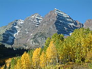
Elk Mountains (Colorado)
Encyclopedia
Mountain range
A mountain range is a single, large mass consisting of a succession of mountains or narrowly spaced mountain ridges, with or without peaks, closely related in position, direction, formation, and age; a component part of a mountain system or of a mountain chain...
in the Rocky Mountains
Rocky Mountains
The Rocky Mountains are a major mountain range in western North America. The Rocky Mountains stretch more than from the northernmost part of British Columbia, in western Canada, to New Mexico, in the southwestern United States...
of west-central Colorado
Colorado
Colorado is a U.S. state that encompasses much of the Rocky Mountains as well as the northeastern portion of the Colorado Plateau and the western edge of the Great Plains...
in the United States
United States
The United States of America is a federal constitutional republic comprising fifty states and a federal district...
. The mountains sit on the western side of the Continental Divide
Continental Divide
The Continental Divide of the Americas, or merely the Continental Gulf of Division or Great Divide, is the name given to the principal, and largely mountainous, hydrological divide of the Americas that separates the watersheds that drain into the Pacific Ocean from those river systems that drain...
, largely in southern Pitkin
Pitkin County, Colorado
Pitkin County is one of the 64 counties of the State of Colorado of the United States. The county is named in honor of the late Colorado Governor Frederick Walker Pitkin. The county population was 14,872 at U.S. Census 2000. The county seat is Aspen...
and northern Gunnison
Gunnison County, Colorado
Gunnison County is the fifth most extensive of the 64 counties of the state of Colorado in the United States. The county population was 15,324 at the 2010 census. The county was named for John W. Gunnison, a United States Army officer and captain in the Army Topographical Engineers, who surveyed...
counties, in the area southwest of Aspen
Aspen, Colorado
The City of Aspen is a Home Rule Municipality that is the county seat and the most populous city of Pitkin County, Colorado, United States. The United States Census Bureau estimates that the city population was 5,804 in 2005...
, south of the Roaring Fork River
Roaring Fork River
Roaring Fork River is a tributary of the Colorado River, approximately long, in west central Colorado in the United States. The river drains a populated and economically vital area of the Colorado Western Slope called the Roaring Fork Valley or Roaring Fork Watershed, which includes the resort...
valley, and east of the Crystal River
Crystal River (Colorado)
The Crystal River is a tributary of the Roaring Fork River, approximately 40 mi long, in western Colorado in the United States. It drains a glacial valley, called the Valley of the Coal Miners, south of Carbondale which was historically known as a center of coal mining in southwestern Colorado...
. The range sits west of the Sawatch Range
Sawatch Range
The Sawatch Range is a mountain range in central Colorado which includes eight of the twenty highest peaks in the Rocky Mountains, including Mount Elbert, at elevation, the highest peak in the Rockies....
and northeast of the West Elk Mountains
West Elk Mountains
The West Elk Mountains are a mountain range in the west-central part of the US state of Colorado. They lie primarily within the Gunnison National Forest, and part of the range is protected as the West Elk Wilderness...
. Much of the range is located within the White River National Forest
White River National Forest
White River National Forest is a National Forest in northwest Colorado. It is named after the White River that passes through it. It also contains the Flat Tops Wilderness Area, largely considered the birthplace of the U.S...
and the Gunnison National Forest
Gunnison National Forest
The Gunnison National Forest is a U.S. National Forest covering 1,672,136 acres in Mesa, Gunnison, Hinsdale and Saguache Counties in Western part of the U.S. state of Colorado...
, as well as the Maroon Bells-Snowmass Wilderness
Maroon Bells-Snowmass Wilderness
The Maroon Bells-Snowmass Wilderness is a U.S. Wilderness Area located in the Elk Mountains of central Colorado. The wilderness was established in 1980 in the Gunnison and White River national forests. Within its boundaries are of trails, 6 of Colorado's fourteeners and 9 passes over ....
and Raggeds Wilderness
Raggeds Wilderness
The Raggeds Wilderness is a U.S. Wilderness Area located northwest of Crested Butte, Colorado. The wilderness established in 1980 in the White River and Gunnison national forests has of trails....
.
The highest peaks in the range are its fourteeners, Castle Peak
Castle Peak (Colorado)
Castle Peak is a fourteener in the Elk Mountains in the US state of Colorado. It is the highest peak in the Elks and the twelfth highest in Colorado. The peak is in Pitkin County near the Gunnison County line and about south of Aspen. The best climbing months are June, July, August, September...
(14,265 ft), Maroon Peak
Maroon Bells
The Maroon Bells are two peaks in the Elk Mountains, Maroon Peak and North Maroon Peak, separated by about a third of a mile. The mountain is on the border between Pitkin County and Gunnison County, Colorado, United States, about 12 miles southwest of Aspen. Both peaks are counted as fourteeners...
(14,156 ft), Capitol Peak
Capitol Peak (Colorado)
Capitol Peak is the thirty-second highest mountain in the U.S. state of Colorado. It is located in the Elk Mountains in southern Pitkin County west of Aspen, within the Maroon Bells-Snowmass Wilderness. It lies on the long ridge connecting the heart of the Elk Mountains with Mount Sopris to the...
(14,130 ft), Snowmass Mountain
Snowmass Mountain
Snowmass Mountain is a fourteen thousand foot mountain in the U.S. state of Colorado. It is the thirty-fourth highest mountain peak in the state. It is located in the Elk Mountains, within the Maroon Bells-Snowmass Wilderness of the White River National Forest...
(14,092 ft), Pyramid Peak
Pyramid Peak (Colorado)
Pyramid Peak is a fourteen thousand foot mountain in the US state of Colorado. It is the 47th highest mountain peak in Colorado, and 78th highest peak in the United States. It is located in the Elk Mountains in southeastern Pitkin County, approximately southwest of Aspen...
(14,018 ft), and North Maroon Peak
Maroon Bells
The Maroon Bells are two peaks in the Elk Mountains, Maroon Peak and North Maroon Peak, separated by about a third of a mile. The mountain is on the border between Pitkin County and Gunnison County, Colorado, United States, about 12 miles southwest of Aspen. Both peaks are counted as fourteeners...
(14,014 ft). Maroon Peak and North Maroon Peak are collectively known as the Maroon Bells
Maroon Bells
The Maroon Bells are two peaks in the Elk Mountains, Maroon Peak and North Maroon Peak, separated by about a third of a mile. The mountain is on the border between Pitkin County and Gunnison County, Colorado, United States, about 12 miles southwest of Aspen. Both peaks are counted as fourteeners...
, a popular destination for recreation alpinism. Mount Sopris
Mount Sopris
Mount Sopris is a high, twin-summitted mountain peak located at the northwest end of the Elk Mountains in western Colorado in the United States. The mountain is located in western Pitkin County, south of Carbondale and southwest of the confluence of the Crystal and Roaring Fork rivers. It lies in...
(12,953 ft) sits at the northwest end of the range and dominates the skyline of the lower Roaring Fork Valley and the town of Carbondale
Carbondale, Colorado
Carbondale is a Home Rule Municipality in Garfield County, Colorado, United States. The population was 5,196 at the 2000 census. The town is located in the mid valley of the Roaring Fork River, downstream from Aspen and upstream from the mouth of the Roaring Fork at Glenwood Springs. The town...
, serving as an unofficial symbol of the area.
Additional notable peaks in the range include:
- Cathedral Peak, 13,943 ft (4,250 m), near Pyramid PeakPyramid Peak (Colorado)Pyramid Peak is a fourteen thousand foot mountain in the US state of Colorado. It is the 47th highest mountain peak in Colorado, and 78th highest peak in the United States. It is located in the Elk Mountains in southeastern Pitkin County, approximately southwest of Aspen...
- Hagerman Peak, 13,841 ft (4,219 m), near Snowmass MountainSnowmass MountainSnowmass Mountain is a fourteen thousand foot mountain in the U.S. state of Colorado. It is the thirty-fourth highest mountain peak in the state. It is located in the Elk Mountains, within the Maroon Bells-Snowmass Wilderness of the White River National Forest...
- Snowmass PeakSnowmass PeakSnowmass Peak in the U.S. state of Colorado dominates the view from Snowmass Lake. It is often mistaken for Snowmass Mountain the thirty-fourth highest mountain peak in the state, as well as for Hagerman Peak. Snowmass Peak is not really a peak but the lower end of Hagerman Peak's east ridge...
, 13,620 ft (4,151 m), near Hagerman Peak - Clark Peak, 13,580 ft (4,139 m), near Capitol PeakCapitol Peak (Colorado)Capitol Peak is the thirty-second highest mountain in the U.S. state of Colorado. It is located in the Elk Mountains in southern Pitkin County west of Aspen, within the Maroon Bells-Snowmass Wilderness. It lies on the long ridge connecting the heart of the Elk Mountains with Mount Sopris to the...
- Treasure Mountain, 13,528 ft (4,123 m), southwest of the Maroon BellsMaroon BellsThe Maroon Bells are two peaks in the Elk Mountains, Maroon Peak and North Maroon Peak, separated by about a third of a mile. The mountain is on the border between Pitkin County and Gunnison County, Colorado, United States, about 12 miles southwest of Aspen. Both peaks are counted as fourteeners...
- Mount Owen, 13,058 ft (3,980 m), high point of the Ruby Range
- Chair Mountain, 12,721 ft (3,877 m), high point of The Raggeds
- Crested ButteCrested ButteCrested Butte is a mountain peak butte of the Elk Mountains in the U.S. State of Colorado. It is also a town with a population of about 2000 people. The greater area includes Crested Butte, Mt. Crested Butte, Riverland, Riverbend, and Crested Butte South....
, 12,162 ft (3,706 m), home of Crested ButteCrested Butte, ColoradoCrested Butte is a Home Rule Municipality in Gunnison County, Colorado, United States. A former coal mining town now called "the last great Colorado ski town," Crested Butte is a destination for skiing, mountain biking, and a variety of other outdoor activities...
Mountain Resort - Whitehouse Mountain, 11,975 ft (3,650 m), northwest of Treasure Mountain
The range provides a formidable barrier to travel and is traversed only by backroad passes and trails, including Schofield Pass
Schofield Pass (Colorado)
Schofield Pass is a high mountain pass located near Crested Butte CO and is one of the most popular ways to get to Snowmass Mountain. It is the high point on Gothic Road, which connects the towns of Marble and Crested Butte. The road to the summit is suitable for a passenger car if traveling from...
, Pearl Pass, and Taylor Pass. State Highway 133
Colorado State Highway 133
State Highway 133 is a long north–south byway connecting State Highway 82 to the north and State Highway 92 to the south, and travels through the towns of Hotchkiss, Somerset, Redstone, and Carbondale. Highway 133 travels over a significant mountain pass on the northern end, called McClure Pass,...
traverses McClure Pass
McClure Pass
McClure Pass is a high mountain pass in the Rocky Mountains of western Colorado in the United States.- Overview :...
, at the western end of the range. The range has been the site of mining activity since the days of the Colorado Silver Boom
Colorado Silver Boom
The Colorado Silver Boom was a dramatic expansionist period of silver mining activity in the U.S. state of Colorado in the late 19th century. The boom started in 1879 with the discovery of silver at Leadville...
, which saw the founding of mining towns such as Aspen and Ashcroft
Ashcroft, Colorado
Ashcroft originally known as Castle Forks City and then Chloride until 1882, was a mining town located ten miles south of Aspen near Castle Creek, in Pitkin County, Colorado, United States. A few buildings remain standing as a testament to the town's past.-The early years:In the spring of 1880 two...
. In the late 19th century, the western and southern flank of the range became the site of intense coal
Coal
Coal is a combustible black or brownish-black sedimentary rock usually occurring in rock strata in layers or veins called coal beds or coal seams. The harder forms, such as anthracite coal, can be regarded as metamorphic rock because of later exposure to elevated temperature and pressure...
mining activity which continues to the present day. Treasure Mountain, overlooking the town of Marble, is home to the famous Yule Marble Quarry. Quarried marble was used to create The Tomb of the Unknowns, the Lincoln Memorial, Denver Post Office and other buildings. The range receives a great deal of snowfall due to its position to the west of the continental divide and the westerly origin of many winter storms. This is exploited by the ski
Skiing
Skiing is a recreational activity using skis as equipment for traveling over snow. Skis are used in conjunction with boots that connect to the ski with use of a binding....
areas in the vinicity of Aspen, which are located on the flanks of smaller mountains alongside the Roaring Fork Valley.
Prominent peaks
| Rank Ranking A ranking is a relationship between a set of items such that, for any two items, the first is either 'ranked higher than', 'ranked lower than' or 'ranked equal to' the second.... |
Mountain Peak Summit (topography) In topography, a summit is a point on a surface that is higher in elevation than all points immediately adjacent to it. Mathematically, a summit is a local maximum in elevation... |
Subrange Mountain range A mountain range is a single, large mass consisting of a succession of mountains or narrowly spaced mountain ridges, with or without peaks, closely related in position, direction, formation, and age; a component part of a mountain system or of a mountain chain... |
Elevation | Prominence Topographic prominence In topography, prominence, also known as autonomous height, relative height, shoulder drop , or prime factor , categorizes the height of the mountain's or hill's summit by the elevation between it and the lowest contour line encircling it and no higher summit... |
Isolation Topographic isolation The topographic isolation of a summit is the minimum horizontal distance to the nearest point of higher elevation. Topographic isolation represents a radius of dominance in which the summit is the highest point. Topographic isolation can be calculated for small hills and islands as well as for... |
|---|---|---|---|---|---|
| 1 | Castle Peak Castle Peak (Colorado) Castle Peak is a fourteener in the Elk Mountains in the US state of Colorado. It is the highest peak in the Elks and the twelfth highest in Colorado. The peak is in Pitkin County near the Gunnison County line and about south of Aspen. The best climbing months are June, July, August, September... |
Elk Mountains | 14,279 feet 4352 m |
2,365 feet 721 m |
20.9 miles 33.7 km |
| 2 | Maroon Peak | Elk Mountains | 14,163 feet 4317 m |
2,336 feet 712 m |
8.1 miles 13.0 km |
| 3 | Capitol Peak Capitol Peak (Colorado) Capitol Peak is the thirty-second highest mountain in the U.S. state of Colorado. It is located in the Elk Mountains in southern Pitkin County west of Aspen, within the Maroon Bells-Snowmass Wilderness. It lies on the long ridge connecting the heart of the Elk Mountains with Mount Sopris to the... |
Elk Mountains | 14,137 feet 4309 m |
1,730 feet 527 m |
7.4 miles 12.0 km |
| 4 | Snowmass Mountain Snowmass Mountain Snowmass Mountain is a fourteen thousand foot mountain in the U.S. state of Colorado. It is the thirty-fourth highest mountain peak in the state. It is located in the Elk Mountains, within the Maroon Bells-Snowmass Wilderness of the White River National Forest... |
Elk Mountains | 14,099 feet 4297 m |
1,132 feet 345 m |
2.3 miles 3.8 km |
| 5 | Pyramid Peak Pyramid Peak (Colorado) Pyramid Peak is a fourteen thousand foot mountain in the US state of Colorado. It is the 47th highest mountain peak in Colorado, and 78th highest peak in the United States. It is located in the Elk Mountains in southeastern Pitkin County, approximately southwest of Aspen... |
Elk Mountains | 14,025 feet 4275 m |
1,618 feet 493 m |
2.1 miles 3.4 km |
| 6 | Cathedral Peak | Elk Mountains | 13,950 feet 4252 m |
503 feet 153 m |
1.3 miles 2.1 km |
| 7 | Treasure Mountain | Elk Mountains | 13,535 feet 4125 m |
2,821 feet 860 m |
6.9 miles 11.1 km |
| 8 | Mount Owen | Ruby Range | 13,070 feet 3984 m |
1,358 feet 414 m |
8.0 miles 12.8 km |
| 9 | West Elk Peak | West Elk Mountains West Elk Mountains The West Elk Mountains are a mountain range in the west-central part of the US state of Colorado. They lie primarily within the Gunnison National Forest, and part of the range is protected as the West Elk Wilderness... |
13,042 feet 3975 m |
3,095 feet 943 m |
13.8 miles 22.2 km |
| 10 | Chair Mountain | Elk Mountains | 12,727 feet 3879 m |
2,461 feet 750 m |
8.9 miles 14.3 km |
| 11 | Mount Gunnison | West Elk Mountains West Elk Mountains The West Elk Mountains are a mountain range in the west-central part of the US state of Colorado. They lie primarily within the Gunnison National Forest, and part of the range is protected as the West Elk Wilderness... |
12,725 feet 3879 m |
3,549 feet 1082 m |
11.8 miles 19.1 km |
| 12 | Gothic Mountain | Elk Mountains | 12,631 feet 3850 m |
1,645 feet 501 m |
3.2 miles 5.2 km |
| 13 | Whetstone Mountain | West Elk Mountains West Elk Mountains The West Elk Mountains are a mountain range in the west-central part of the US state of Colorado. They lie primarily within the Gunnison National Forest, and part of the range is protected as the West Elk Wilderness... |
12,527 feet 3818 m |
2,456 feet 749 m |
9.4 miles 15.1 km |
| 14 | East Beckwith Mountain | West Elk Mountains West Elk Mountains The West Elk Mountains are a mountain range in the west-central part of the US state of Colorado. They lie primarily within the Gunnison National Forest, and part of the range is protected as the West Elk Wilderness... |
12,441 feet 3792 m |
2,492 feet 760 m |
6.8 miles 11.0 km |
| 15 | Anthracite Peak | West Elk Mountains West Elk Mountains The West Elk Mountains are a mountain range in the west-central part of the US state of Colorado. They lie primarily within the Gunnison National Forest, and part of the range is protected as the West Elk Wilderness... |
12,394 feet 3778 m |
2,125 feet 648 m |
4.8 miles 7.7 km |
| 16 | Matchless Mountain Matchless Mountain Matchless Mountain is a mountain which rises to 1,140 m on the south margin of the Fry Glacier, at the juncture of Atka Glacier, in Convoy Range, Victoria Land. The name was suggested by New Zealand geologist Christopher J... |
Elk Mountains | 12,389 feet 3776 m |
1,763 feet 537 m |
9.6 miles 15.5 km |
| 17 | Crested Butte Crested Butte Crested Butte is a mountain peak butte of the Elk Mountains in the U.S. State of Colorado. It is also a town with a population of about 2000 people. The greater area includes Crested Butte, Mt. Crested Butte, Riverland, Riverbend, and Crested Butte South.... |
Elk Mountains | 12,168 feet 3709 m |
2,582 feet 787 m |
4.7 miles 7.5 km |
| 18 | Carbon Peak | West Elk Mountains West Elk Mountains The West Elk Mountains are a mountain range in the west-central part of the US state of Colorado. They lie primarily within the Gunnison National Forest, and part of the range is protected as the West Elk Wilderness... |
12,088 feet 3684 m |
2,179 feet 664 m |
3.9 miles 6.3 km |
| 19 | Mount Guero | West Elk Mountains West Elk Mountains The West Elk Mountains are a mountain range in the west-central part of the US state of Colorado. They lie primarily within the Gunnison National Forest, and part of the range is protected as the West Elk Wilderness... |
12,058 feet 3675 m |
2,432 feet 741 m |
6.4 miles 10.3 km |
| 20 | Huntsman Mountain Northwest | Elk Mountains | 11,858 feet 3614 m |
3,072 feet 936 m |
10.3 miles 16.6 km |
| 21 | Marcellina Mountain | West Elk Mountains West Elk Mountains The West Elk Mountains are a mountain range in the west-central part of the US state of Colorado. They lie primarily within the Gunnison National Forest, and part of the range is protected as the West Elk Wilderness... |
11,353 feet 3461 m |
2,728 feet 831 m |
5.1 miles 8.2 km |
See also
- Geography of ColoradoGeography of ColoradoThe geography of the state of Colorado is diverse, encompassing both rugged mountainous terrain, vast plains, desert lands, desert canyons, and mesas. The state of Colorado is defined as the geospherical rectangle that stretches from 37°N to 41°N latitude and from 102°03'W to 109°03'W longitude . ...
- Mountain peaks of ColoradoMountain peaks of ColoradoThis article comprises three sortable tables of the major mountain peaks of the U.S. State of Colorado.Topographic elevation is the vertical distance above the reference geoid, a precise mathematical model of the Earth's sea level as an equipotential gravitational surface...
- Mountain ranges of ColoradoMountain ranges of ColoradoThe following table lists the major mountain ranges of the U.S. State of Colorado.-Mountain Ranges:-See also:*4000 meter peaks of Colorado*Colorado mountain passes*Geography of Colorado*Lists of mountains*Mountain peaks of Colorado...
- State of Colorado