
Mount Greylock
Encyclopedia
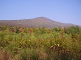
Mount Greylock is the highest natural point in Massachusetts
at 3489 feet (1,063.4 m). Its peak is located in the northwest corner of the state in the western part of the town of Adams
(near its border with Williamstown
) in Berkshire County
. Although geologically part of the Taconic Mountains
, Mount Greylock is commonly associated with the abutting Berkshire Hills to the east. The mountain is known for its expansive views encompassing five states and the only taiga
-boreal
forest in the state. A seasonal automobile road (open annually from late May through November 1) climbs to the summit, where stands the iconic 93 feet (28.3 m) lighthouse-like Massachusetts Veterans War Memorial Tower. A network of hiking trails traverse the mountain, including the 2179 miles (3,506.8 km) Appalachian Trail
. Mount Greylock State Reservation
was created in 1898 as Massachusetts' first public land for the purpose of forest preservation.
to the east, the Green Mountains
to the north, the Berkshires to both the south and east, and the Taconic Mountains
to the west with which it is geologically associated; all ranges are associated with the Appalachian mountain chain
. The summit of Mount Greylock is located in Adams, Massachusetts
, but the mountain also extends into Cheshire
, Lanesborough
, New Ashford
, North Adams
and Williamstown
. The range includes peaks with elevation less than Greylock, such as Saddle Ball Mountain and Mount Fitch
.
On average, Mount Greylock rises 2000 ft (609.6 m) above surrounding river valleys and 1000 ft (304.8 m) above the Berkshires and Taconic Mountains. From the summit, views of up to 70–135 mi (112.7–217.3 km) are possible into five different states: Massachusetts, New York
, Connecticut
, Vermont
, and New Hampshire
.
The northwest side of Mount Greylock drains into the Green River, then into the Hoosic River
, Hudson River
, and New York Harbor. The south side of the mountain drains into Town Brook, then into the Housatonic River
and Long Island Sound. The rest of the mountain drains into the Hoosic River
.
 Mount Greylock and the neighboring Taconic Mountains are comprised predominately of Ordovician
phyllite
, a metamorphic rock
, overlain on younger layers of metamorphized sedimentary rock, especially marble
. Mount Greylock is the product of thrust fault
ing, a tectonic process by which older rock is thrust up and above younger rock during periods of intense mountain building. The younger, underlying marble bedrock layers have been quarried in the lower foothills of the mountain in nearby Adams
and North Adams, Massachusetts
. During the Pleistocene
, 18,000 years ago, Mount Greylock and the surrounding region were covered by ice sheets up to 1 kilometre (0.621372736649807 mi) in thickness. Glaciation rounded and wore down the mountain, carving out U-shaped valleys and leaving glacial erratics such as the balanced rock on the west side of Greylock. The Hopper, a cirque
, also located on the west side of Greylock, is the southernmost such glacial feature in New England.
species while upper summits are dominated by boreal balsam fir
and red spruce
. The ridgeline of Greylock, between Mount Fitch on the north and Saddle Ball on the south, is the only place in Massachusetts where a taiga
-boreal or sub-alpine forest flourishes. Researchers have identified 555 acres (2.2 km²) of old growth forest on the mountain. The steep western slopes (which include The Hopper) contain northern hardwood forest biome
species up to 350 years old, including a 120 feet (36.6 m) red spruce. Because of its extensive stands of red spruce old growth, The Hopper has been designated a National Natural Landmark
.
the Mahican
people were closely associated with this region. The traditional trade route connecting the tribes of the Hudson
and Connecticut River
valleys (today, Route 2, known as the Mohawk Trail
) passes beneath the northern flank of Mount Greylock.
The mountain was known to 18th century English settlers as Grand Hoosuc(k). In the early 19th century it was called Saddleback Mountain because of its appearance (Saddle Ball, the name of the peak to the south, still reflects this).
The origin of the present name of Greylock and its association with the mountain is unclear. It first appeared in print about 1819, and came into popular use by the 1830s. It may be in reference to its appearance, as it often has a gray cloud, or lock of gray mist upon his head, or in tribute to a legendary Native American
chief, Gray Lock
. Gray Lock (c. 1670-1750) was a Western Abenaki Missisquoi chief of Woronoco-Pocomtuc
ancestry, born near Westfield, Massachusetts
. Gray Lock distinguished himself by conducting guerrilla raids into Vermont and western Massachusetts.
 Timothy Dwight IV
, President of Yale University, along with Williams College President Ebenezer Fitch, climbed Greylock in 1799, probably over a rough route cut by a local pioneer farmer Jeremiah Wilbur (in that time more land had been cleared on the slopes for farming than today). His account in Travels in New England and New York describes the experience, although he noted the summit vegetation was so thick he and Fitch had to climb a balsam fir
tree to get a better view:
Williams College
, founded in 1793 in nearby Williamstown, has always been closely associated with Greylock and the study of its natural history. On May 12, 1830, a group of students directed by college President Edward Dorr Griffin improved and further cut a trail from the end of the Hopper Road to the summit. Today this route is the Hopper Trail, traditionally climbed by students once a year on Mountain Day
.
In May 1831 the first wooden meteorological
observatory, "Griffin's Tower", was built on the summit by students. Nine years later, it was replaced by a more substantial 60-foot (20 m) tall wooden observatory tower, from which Donati's Comet was photographed in 1858. In 1863 the first organized hiking and nature study club in the United States, the Alpine Club, was founded by Professor Albert Hopkins. The club frequently camped
on the mountain.
 By the mid-19th century improved transportation into the region attracted many visitors to Greylock. Among them were writers and artists inspired by the mountain scene: Nathaniel Hawthorne
, William Cullen Bryant
, Oliver Wendell Holmes
, Herman Melville
, and Henry David Thoreau
.
In the summer of 1838, Hawthorne had visited North Adams, Massachusetts
and climbed Mount Greylock several times. His experiences there, specifically a walk he took at midnight where he saw a burning lime kiln, inspired his story, originally titled "The Unpardonable Sin". Hawthorne had not written tales since 1844 when he wrote "Ethan Brand
" in the winter of 1848–1849.
Melville is said to have taken part of his inspiration for Moby-Dick
from the view of the mountain from his house Arrowhead
in Pittsfield
, since its snow-covered profile reminded him of a great white Sperm Whale
's back breaking the ocean's surface. Melville dedicated his next novel, Pierre
, to "Greylock's Most Excellent Majesty", calling the mountain "my own... sovereign lord and king". Thoreau summited and spent a night in July 1844. His account of this event in A Week on the Concord and Merrimack Rivers
described his approach up what is today the Bellows Pipe Trail. Scholars contend that this Greylock experience transformed him, affirming his ability to do these excursions on his own, following his brother John's death; and served as a prelude to his experiment of rugged individualism at Walden Pond
the following year in 1845.
By the late 19th century, clear-cutting logging
practices had stripped much of the mountain for local industries that produced wood products, paper
and charcoal
. Along with this came devastating forest fires and landslide
s. Following a fire on the summit, a group of local businessmen concerned about the mountain incorporated
the Greylock Park Association (GPA) on July 20, 1885, and purchased 400 acre (1.6 km²) on the summit. The GPA also undertook long-needed repairs to the Notch Road so that carriages could access the top. Aside from shares to fund its operation, the GPA charged a 25-cent toll for the carriage road and a 10-cent fee to ascend the iron observation tower
(built 1889). These fees are equivalent to $ in present day dollars.
By early 1897, with the GPA venture in debt, conservation interests in the state sought to protect the mountain through other means. Legislation was filed by William H. Chase, editor of the Berkshire Sunday Democrat of North Adams, under the auspices of the Board of Trade of North Adams to transfer the GPA land holdings on the mountain to the Commonwealth of Massachusetts for a state reservation. This included supporting testimony from Williams College geology professor T. Nelson Dale, and a $25,000 appropriation bill filed through Judge Arthur M. Robinson. Additional support came from the Massachusetts Forestry Association's initiative to advocate for the establishment of a state park system, and to make the case point, fight inappropriate development of the state's highest peak, Mount Greylock. The principal argument for making the mountain a public reservation was to protect the Hoosic
and Housatonic River
watersheds from erosion due to recent trends of deforestation (particularly noted on the Adams side). Another concern was to preserve it for the public rather than private and exclusive enjoyment. On June 20, 1898 Mount Greylock State Reservation was created, with the stipulation that the state add to the original land (to ultimately total 10000 acre (40.5 km²)). With this acquisition the first public land in Massachusetts for the purpose of forest preservation was created, later to become the state park system. A three-person, governor-appointed Greylock Reservation Commission, a body of Berkshire County government, was entrusted with the care and maintenance of the reservation. The title "Reservation" refers to county management of state land, since there was only one state forester and a handful of state fire wardens in service at the time; similarly other early State Reservation properties in Massachusetts were previously managed and operated by county commissions for the state.
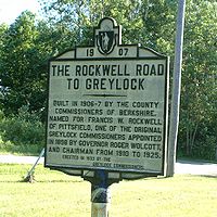
 In 1906, Berkshire County began survey and construction of another approach, the first direct route from the south to the summit. It was opened to the public on September 16, 1907, running "through six farms ... passing Round’s Rock, a fine view point, and throughout its entire distance affords unsurpassed views of Berkshire hills and valleys lying to the south and west of the reservation". Afterwards the Commission turned its attention to the foot trail development, and by 1913 it was able to boast that 17 trails existed on the mountain.
By 1929, the Appalachian Trail
route up Mount Greylock was first cut, and most of the Massachusetts section route was complete by 1931. Due to disputes between the local Berkshire Hills Conference trail group and both the Appalachian Trail Conference and the Appalachian Mountain Club
Berkshire Chapter, the trail was in jeopardy of growing back in until the local Mount Greylock Ski Club assumed maintenance in 1937.
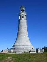
The greatest period of development on Mount Greylock occurred in the 1930s. The Massachusetts (Veterans) War Memorial Tower on the summit was constructed (1931–32). The Civilian Conservation Corps
(CCC) 107th Company, MA camp SP-7, from 1933-1941 made extensive improvements on roads, trails, scenic vistas, firebreaks, forest health improvement, and recreation area development. Some of the more significant CCC features included development of the road system (gravel surfaced) to accommodate automobiles, Adirondack lean-to shelters, the Thunderbolt Ski Shelter, and completion of Bascom Lodge. As a result of increased popularity of winter recreation and downhill skiing, the Mount Greylock Ski Club initiated a plan to create a challenging ski run on Mount Greylock. The planning skills of Dwight J. Francis and Western Massachusetts Winter Sports Council, including input from Williams, Amherst, Smith, Mount Holyoke, and Massachusetts State Colleges, Greenfield Outing Club, and the Green Mountain Club, resulted in the CCC building the Thunderbolt Ski Trail in 1934 (named for its resemblance to a Revere Beach
, MA, roller coaster). The lower section of the Thunderbolt Trail was relocated in 1936 by Charles L. Parker. This ski trail was rated Expert-Class A by the United States Eastern Amateur Ski Association (USEASA, today the United States Ski and Snowboard Association
) and later host site for the USEASA Championship Races in 1938 and 1940. The trail was used for numerous competitive downhill ski races up until 1959.
Based on the popular response to winter recreation at Mount Greylock, a New York-based group expressed interest to the Greylock Commission to develop a cable tramway and downhill ski area on southwest portion of mountain in 1941. The proposal, though defeated, initiated an ongoing debate between the use of Mount Greylock (State) Reservation for commercial development and open hunting versus conservation purposes.
In October 1966, following years of legal disputes over the Greylock Commission's perceived abuses of allowing public land for commercial use, a conservation group called the Mount Greylock Protective Association led a campaign that transferred ultimate responsibility for management and operation the mountain from Berkshire County to the state park system.
) and provides orientation, trail maps, informational brochures, exhibits, and accessible rest rooms. Five lean-to
shelters and Mount Greylock Campground are available for backpacking
. About 70 mi (112.7 km) of trails are located on the mountain, including the Appalachian Trail
.
 Prominent features on the summit are the Massachusetts Veterans War Memorial Tower, Bascom Lodge, the Thunderbolt Ski Shelter, and a television and radio tower. Because of the cultural significance of the mountain and excellent examples CCC period park structures, the Mount Greylock Summit Historic District was added to the National Register of Historic Places
in on April 20, 1998, reference number 98000349.
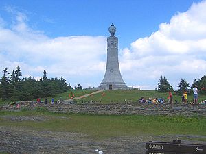
The Veterans War Memorial Tower was approved by the state legislature in October 1930, supported by Senator Theodore Plunkett of Adams and Governor Frank G. Allen
. The memorial was originally intended to be erected in Boston
's Charles River Basin, before plans were changed to build it on Mount Greylock. It was designed by Boston-based architects Maginnis & Walsh
, and built by contractors John G. Roy & Son of Springfield in 1931-32 at a cost of $200,000. It takes the form of a perpetually lighted beacon to honor the state's dead from World War I
(and subsequent conflicts). The light used to be the strongest beacon in Massachusetts, with a nighttime visible range of up to 70 miles.
The architectural design of the tower, a 93 feet (28 m) tall shaft with eight frieze-framed observation openings, was intended to have no suggestion of Utilitarianism
but instead to display classic austerity. It includes some minor Art Deco
details such as the decorative eagle
on the base which were designed in part by John Bizzozero of Quincy, Massachusetts [Bizzozero also designed details on the Vermont Capitol building]. Inside it is a domed chamber for a reverential shine that was intended to store tablets and war relicts from wartime units in the state's history.
Although local legislators and residents advocated for local stone to be used, it was ultimately quarried
from Quincy
Granite. In part, it bears the inscription "they were faithful even unto death." One of the inscriptions inside the monument is, "Of those immortal dead who live again in the minds made better by their presence", which is a line from a poem by George Eliot
. The translucent globe
of light on top, originally illuminated by twelve 1,500 watt lights (now six), is said to be visible at night for 70 mi (112.7 km). The formal dedication ceremony on June 30, 1933 by Governor Joseph B. Ely
was attended by about 1,500 and broadcast nationally over NBC
radio
.
 Bascom Lodge was built between 1932-1938 using native materials of Greylock schist
and red spruce
. Designed by Pittsfield architect, Joseph McArthur Vance, it displays the rustic architectural design of period park structures. The Greylock Commission had desired to rebuild a more substantial shelter for visitors and hikers to the summit after the previous summit house (built c.1902) burned down in 1929. The initial west wing was constructed in 1932 by Jules Emil Deloye, Jr. The main-central and east wings were completed later 1935-38 by the CCC
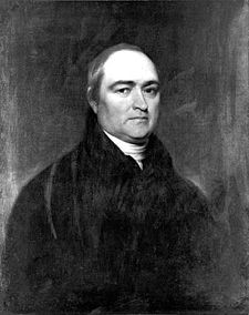
, supervised by Deloye. The lodge was named in honor of John Bascom
, a Greylock Reservation Commissioner and Williams College professor, who had a strong association with the mountain during his lifetime.
Today, Bascom Lodge is run by the Bascom Lodge Group, in partnership with the Massachusetts Department of Conservation and Recreation's Historic Curatorship Program.
The Thunderbolt Ski Shelter, also designed by Joseph McArthur Vance, was built in 1940 by the CCC to principally serve as a warming hut for skiers using the Thunderbolt Trail. Also rustic in design and built of stone and wood beams, the interior has four wooden benches built into a large four hearth fireplace in the center.
Greylock Glen, site of a former proposed tramway/ski/resort development from 1953–1977, is a 1063 acre (4.3 km²) state park located in the town of Adams, adjoining Mount Greylock State Reservation. It was acquired by the state in 1985 to create a regional economic facility in the form of a joint public-private development.
Three radio and television stations transmit from a broadcast tower below the summit on the west side: WAMC
(90.3 Albany, New York
); WCDC-TV
(19/36 Adams, Massachusetts
); and W38DL (38 Adams, Massachusetts
(Repeater of WNYT-TV). A NOAA Weather Radio station (WWF-48, 162.525 MHz) broadcasts from a different tower on the mountain.
Massachusetts
The Commonwealth of Massachusetts is a state in the New England region of the northeastern United States of America. It is bordered by Rhode Island and Connecticut to the south, New York to the west, and Vermont and New Hampshire to the north; at its east lies the Atlantic Ocean. As of the 2010...
at 3489 feet (1,063.4 m). Its peak is located in the northwest corner of the state in the western part of the town of Adams
Adams, Massachusetts
Adams is a town in Berkshire County, Massachusetts, United States. It is part of the Pittsfield, Massachusetts Metropolitan Statistical Area. The population was 8,485 at the 2010 census.-History:...
(near its border with Williamstown
Williamstown, Massachusetts
Williamstown is a town in Berkshire County, in the northwest corner of Massachusetts. It shares a border with Vermont to the north and New York to the west. It is part of the Pittsfield, Massachusetts Metropolitan Statistical Area. The population was 7,754 at the 2010 census...
) in Berkshire County
Berkshire County, Massachusetts
Berkshire County is a non-governmental county located on the western edge of the U.S. state of Massachusetts. As of the 2010 census, the population was 131,219. Its largest city and traditional county seat is Pittsfield...
. Although geologically part of the Taconic Mountains
Taconic Mountains
The Taconic Mountains or Taconic Range are a physiographic section of the larger New England province and part of the Appalachian Mountains, running along the eastern border of New York State and adjacent New England from northwest Connecticut to western Massachusetts, north to central western...
, Mount Greylock is commonly associated with the abutting Berkshire Hills to the east. The mountain is known for its expansive views encompassing five states and the only taiga
Taiga
Taiga , also known as the boreal forest, is a biome characterized by coniferous forests.Taiga is the world's largest terrestrial biome. In North America it covers most of inland Canada and Alaska as well as parts of the extreme northern continental United States and is known as the Northwoods...
-boreal
Boreal ecosystem
The term boreal is usually applied to ecosystems localized in subarctic and subantarctic zones, although Austral is also used for the latter....
forest in the state. A seasonal automobile road (open annually from late May through November 1) climbs to the summit, where stands the iconic 93 feet (28.3 m) lighthouse-like Massachusetts Veterans War Memorial Tower. A network of hiking trails traverse the mountain, including the 2179 miles (3,506.8 km) Appalachian Trail
Appalachian Trail
The Appalachian National Scenic Trail, generally known as the Appalachian Trail or simply the AT, is a marked hiking trail in the eastern United States extending between Springer Mountain in Georgia and Mount Katahdin in Maine. It is approximately long...
. Mount Greylock State Reservation
Mount Greylock State Reservation
Mount Greylock State Reservation is a Massachusetts state park that was created in 1898 as Massachusetts' first public land for the purpose of forest preservation. It is located on its namesake Mount Greylock.-History:...
was created in 1898 as Massachusetts' first public land for the purpose of forest preservation.
Geography
Geographically, Mount Greylock is part of a 11 miles (17.7 km) by 4.5 miles (7.2 km) island-like range that runs north-south between the Hoosac RangeHoosac Range
The Hoosac Range is part of both the Berkshires of western Massachusetts and the southern Green Mountains of Vermont; it is part of the greater Appalachian Mountain chain...
to the east, the Green Mountains
Green Mountains
The Green Mountains are a mountain range in the U.S. state of Vermont. The range extends approximately .-Peaks:The most notable mountains in the range include:*Mount Mansfield, , the highest point in Vermont*Killington Peak, *Mount Ellen,...
to the north, the Berkshires to both the south and east, and the Taconic Mountains
Taconic Mountains
The Taconic Mountains or Taconic Range are a physiographic section of the larger New England province and part of the Appalachian Mountains, running along the eastern border of New York State and adjacent New England from northwest Connecticut to western Massachusetts, north to central western...
to the west with which it is geologically associated; all ranges are associated with the Appalachian mountain chain
Appalachian Mountains
The Appalachian Mountains #Whether the stressed vowel is or ,#Whether the "ch" is pronounced as a fricative or an affricate , and#Whether the final vowel is the monophthong or the diphthong .), often called the Appalachians, are a system of mountains in eastern North America. The Appalachians...
. The summit of Mount Greylock is located in Adams, Massachusetts
Adams, Massachusetts
Adams is a town in Berkshire County, Massachusetts, United States. It is part of the Pittsfield, Massachusetts Metropolitan Statistical Area. The population was 8,485 at the 2010 census.-History:...
, but the mountain also extends into Cheshire
Cheshire, Massachusetts
Cheshire is a town in Berkshire County, Massachusetts, United States. It is part of the Pittsfield, Massachusetts Metropolitan Statistical Area. The population was 3,401 at the 2000 census.-History:...
, Lanesborough
Lanesborough, Massachusetts
Lanesborough is a town in Berkshire County, Massachusetts, United States. It is part of the Pittsfield, Massachusetts Metropolitan Statistical Area. The population was 2,990 at the 2000 census.-History:...
, New Ashford
New Ashford, Massachusetts
New Ashford is a town in Berkshire County, Massachusetts, United States. It is part of the Pittsfield, Massachusetts Metropolitan Statistical Area. The population was 247 at the 2000 census.- History :...
, North Adams
North Adams, Massachusetts
North Adams is a city in Berkshire County, Massachusetts, United States. It is part of the Pittsfield, Massachusetts Metropolitan Statistical Area. The population was 13,708 as of the 2010 census, making it the least populous city in the state...
and Williamstown
Williamstown, Massachusetts
Williamstown is a town in Berkshire County, in the northwest corner of Massachusetts. It shares a border with Vermont to the north and New York to the west. It is part of the Pittsfield, Massachusetts Metropolitan Statistical Area. The population was 7,754 at the 2010 census...
. The range includes peaks with elevation less than Greylock, such as Saddle Ball Mountain and Mount Fitch
Mount Fitch
Mount Fitch can refer to* Mount Fitch, a subordinate peak of Mount Greylock, located in Massachusetts.*Mount Fitch, Northern Territory, a mountain of approximately 70 m in Australia, part of the old Rum Jungle, Northern Territory uranium mines near Batchelor, 64 km south of Darwin, Northern...
.
On average, Mount Greylock rises 2000 ft (609.6 m) above surrounding river valleys and 1000 ft (304.8 m) above the Berkshires and Taconic Mountains. From the summit, views of up to 70–135 mi (112.7–217.3 km) are possible into five different states: Massachusetts, New York
New York
New York is a state in the Northeastern region of the United States. It is the nation's third most populous state. New York is bordered by New Jersey and Pennsylvania to the south, and by Connecticut, Massachusetts and Vermont to the east...
, Connecticut
Connecticut
Connecticut is a state in the New England region of the northeastern United States. It is bordered by Rhode Island to the east, Massachusetts to the north, and the state of New York to the west and the south .Connecticut is named for the Connecticut River, the major U.S. river that approximately...
, Vermont
Vermont
Vermont is a state in the New England region of the northeastern United States of America. The state ranks 43rd in land area, , and 45th in total area. Its population according to the 2010 census, 630,337, is the second smallest in the country, larger only than Wyoming. It is the only New England...
, and New Hampshire
New Hampshire
New Hampshire is a state in the New England region of the northeastern United States of America. The state was named after the southern English county of Hampshire. It is bordered by Massachusetts to the south, Vermont to the west, Maine and the Atlantic Ocean to the east, and the Canadian...
.
The northwest side of Mount Greylock drains into the Green River, then into the Hoosic River
Hoosic River
The Hoosic River, also known as the Hoosac, the Hoosick and the Hoosuck , is a tributary of the Hudson River in the northeastern United States. The different spellings are the result of varying transliterations of the river's original Algonquian name...
, Hudson River
Hudson River
The Hudson is a river that flows from north to south through eastern New York. The highest official source is at Lake Tear of the Clouds, on the slopes of Mount Marcy in the Adirondack Mountains. The river itself officially begins in Henderson Lake in Newcomb, New York...
, and New York Harbor. The south side of the mountain drains into Town Brook, then into the Housatonic River
Housatonic River
The Housatonic River is a river, approximately long, in western Massachusetts and western Connecticut in the United States. It flows south to southeast, and drains about of southwestern New England into Long Island Sound...
and Long Island Sound. The rest of the mountain drains into the Hoosic River
Hoosic River
The Hoosic River, also known as the Hoosac, the Hoosick and the Hoosuck , is a tributary of the Hudson River in the northeastern United States. The different spellings are the result of varying transliterations of the river's original Algonquian name...
.
Geology and ecosystem
Ordovician
The Ordovician is a geologic period and system, the second of six of the Paleozoic Era, and covers the time between 488.3±1.7 to 443.7±1.5 million years ago . It follows the Cambrian Period and is followed by the Silurian Period...
phyllite
Phyllite
Phyllite is a type of foliated metamorphic rock primarily composed of quartz, sericite mica, and chlorite; the rock represents a gradation in the degree of metamorphism between slate and mica schist. Minute crystals of graphite, sericite, or chlorite impart a silky, sometimes golden sheen to the...
, a metamorphic rock
Metamorphic rock
Metamorphic rock is the transformation of an existing rock type, the protolith, in a process called metamorphism, which means "change in form". The protolith is subjected to heat and pressure causing profound physical and/or chemical change...
, overlain on younger layers of metamorphized sedimentary rock, especially marble
Marble
Marble is a metamorphic rock composed of recrystallized carbonate minerals, most commonly calcite or dolomite.Geologists use the term "marble" to refer to metamorphosed limestone; however stonemasons use the term more broadly to encompass unmetamorphosed limestone.Marble is commonly used for...
. Mount Greylock is the product of thrust fault
Thrust fault
A thrust fault is a type of fault, or break in the Earth's crust across which there has been relative movement, in which rocks of lower stratigraphic position are pushed up and over higher strata. They are often recognized because they place older rocks above younger...
ing, a tectonic process by which older rock is thrust up and above younger rock during periods of intense mountain building. The younger, underlying marble bedrock layers have been quarried in the lower foothills of the mountain in nearby Adams
Adams, Massachusetts
Adams is a town in Berkshire County, Massachusetts, United States. It is part of the Pittsfield, Massachusetts Metropolitan Statistical Area. The population was 8,485 at the 2010 census.-History:...
and North Adams, Massachusetts
North Adams, Massachusetts
North Adams is a city in Berkshire County, Massachusetts, United States. It is part of the Pittsfield, Massachusetts Metropolitan Statistical Area. The population was 13,708 as of the 2010 census, making it the least populous city in the state...
. During the Pleistocene
Pleistocene
The Pleistocene is the epoch from 2,588,000 to 11,700 years BP that spans the world's recent period of repeated glaciations. The name pleistocene is derived from the Greek and ....
, 18,000 years ago, Mount Greylock and the surrounding region were covered by ice sheets up to 1 kilometre (0.621372736649807 mi) in thickness. Glaciation rounded and wore down the mountain, carving out U-shaped valleys and leaving glacial erratics such as the balanced rock on the west side of Greylock. The Hopper, a cirque
Cirque
Cirque may refer to:* Cirque, a geological formation* Makhtesh, an erosional landform found in the Negev desert of Israel and Sinai of Egypt*Cirque , an album by Biosphere* Cirque Corporation, a company that makes touchpads...
, also located on the west side of Greylock, is the southernmost such glacial feature in New England.
Forests and old growth
During the 19th century, much of the mountain was denuded by logging, fires, and grazing. Forests have since reclaimed the mountain. Several forest communities exist on Mount Greylock. Lower slopes are inhabited by northern hardwood forestNorthern hardwood forest
The northern hardwood forest is a general type of North American forest ecosystem found over much of southeastern and south central Canada, extending south into the United States in northern New England and New York, and west along the Great Lakes to Minnesota and western Ontario...
species while upper summits are dominated by boreal balsam fir
Balsam Fir
The balsam fir is a North American fir, native to most of eastern and central Canada and the northeastern United States .-Growth:It is a small to medium-size evergreen tree typically tall, rarely to tall, with a narrow conic crown...
and red spruce
Red Spruce
Picea rubens is a species of spruce native to eastern North America, ranging from eastern Quebec to Nova Scotia, and from New England south in the Adirondack Mountains and Appalachians to western North Carolina.-Physical description:...
. The ridgeline of Greylock, between Mount Fitch on the north and Saddle Ball on the south, is the only place in Massachusetts where a taiga
Taiga
Taiga , also known as the boreal forest, is a biome characterized by coniferous forests.Taiga is the world's largest terrestrial biome. In North America it covers most of inland Canada and Alaska as well as parts of the extreme northern continental United States and is known as the Northwoods...
-boreal or sub-alpine forest flourishes. Researchers have identified 555 acres (2.2 km²) of old growth forest on the mountain. The steep western slopes (which include The Hopper) contain northern hardwood forest biome
Biome
Biomes are climatically and geographically defined as similar climatic conditions on the Earth, such as communities of plants, animals, and soil organisms, and are often referred to as ecosystems. Some parts of the earth have more or less the same kind of abiotic and biotic factors spread over a...
species up to 350 years old, including a 120 feet (36.6 m) red spruce. Because of its extensive stands of red spruce old growth, The Hopper has been designated a National Natural Landmark
National Natural Landmark
The National Natural Landmark program recognizes and encourages the conservation of outstanding examples of the natural history of the United States. It is the only natural areas program of national scope that identifies and recognizes the best examples of biological and geological features in...
.
Early history and naming
Prior to the arrival of EuropeansEuropean colonization of the Americas
The start of the European colonization of the Americas is typically dated to 1492. The first Europeans to reach the Americas were the Vikings during the 11th century, who established several colonies in Greenland and one short-lived settlement in present day Newfoundland...
the Mahican
Mahican
The Mahican are an Eastern Algonquian Native American tribe, originally settling in the Hudson River Valley . After 1680, many moved to Stockbridge, Massachusetts. During the early 1820s and 1830s, most of the Mahican descendants migrated westward to northeastern Wisconsin...
people were closely associated with this region. The traditional trade route connecting the tribes of the Hudson
Hudson River
The Hudson is a river that flows from north to south through eastern New York. The highest official source is at Lake Tear of the Clouds, on the slopes of Mount Marcy in the Adirondack Mountains. The river itself officially begins in Henderson Lake in Newcomb, New York...
and Connecticut River
Connecticut River
The Connecticut River is the largest and longest river in New England, and also an American Heritage River. It flows roughly south, starting from the Fourth Connecticut Lake in New Hampshire. After flowing through the remaining Connecticut Lakes and Lake Francis, it defines the border between the...
valleys (today, Route 2, known as the Mohawk Trail
Mohawk Trail
- External links :* *...
) passes beneath the northern flank of Mount Greylock.
The mountain was known to 18th century English settlers as Grand Hoosuc(k). In the early 19th century it was called Saddleback Mountain because of its appearance (Saddle Ball, the name of the peak to the south, still reflects this).
The origin of the present name of Greylock and its association with the mountain is unclear. It first appeared in print about 1819, and came into popular use by the 1830s. It may be in reference to its appearance, as it often has a gray cloud, or lock of gray mist upon his head, or in tribute to a legendary Native American
Native Americans in the United States
Native Americans in the United States are the indigenous peoples in North America within the boundaries of the present-day continental United States, parts of Alaska, and the island state of Hawaii. They are composed of numerous, distinct tribes, states, and ethnic groups, many of which survive as...
chief, Gray Lock
Gray Lock
Chief Gray Lock , was a Western Abenaki Missisquoi chief of Woronoco/Pocumtuck ancestry. Gray Lock was born near Westfield, Massachusetts, around 1670...
. Gray Lock (c. 1670-1750) was a Western Abenaki Missisquoi chief of Woronoco-Pocomtuc
Pocomtuc
The Pocumtuck, also Pocomtuc or Deerfield Indians, were a Native American tribe formerly inhabiting western Massachusetts, especially around the confluence of the Deerfield and Connecticut Rivers in Franklin County. Their territory also included parts of Hampden and Hampshire County, as well as...
ancestry, born near Westfield, Massachusetts
Westfield, Massachusetts
Westfield is a city in Hampden County, in the Pioneer Valley of western Massachusetts, United States. It is part of the Springfield, Massachusetts Metropolitan Statistical Area. The population was 41,094 at the 2010 census. The ZIP Code is 01085 for homes and businesses, 01086 for Westfield State...
. Gray Lock distinguished himself by conducting guerrilla raids into Vermont and western Massachusetts.
The 1800s
Timothy Dwight IV
Timothy Dwight was an American academic and educator, a Congregationalist minister, theologian, and author...
, President of Yale University, along with Williams College President Ebenezer Fitch, climbed Greylock in 1799, probably over a rough route cut by a local pioneer farmer Jeremiah Wilbur (in that time more land had been cleared on the slopes for farming than today). His account in Travels in New England and New York describes the experience, although he noted the summit vegetation was so thick he and Fitch had to climb a balsam fir
Balsam Fir
The balsam fir is a North American fir, native to most of eastern and central Canada and the northeastern United States .-Growth:It is a small to medium-size evergreen tree typically tall, rarely to tall, with a narrow conic crown...
tree to get a better view:
Williams College
Williams College
Williams College is a private liberal arts college located in Williamstown, Massachusetts, United States. It was established in 1793 with funds from the estate of Ephraim Williams. Originally a men's college, Williams became co-educational in 1970. Fraternities were also phased out during this...
, founded in 1793 in nearby Williamstown, has always been closely associated with Greylock and the study of its natural history. On May 12, 1830, a group of students directed by college President Edward Dorr Griffin improved and further cut a trail from the end of the Hopper Road to the summit. Today this route is the Hopper Trail, traditionally climbed by students once a year on Mountain Day
Mountain Day
Mountain Day is a traditional student celebration in which classes are cancelled without prior notice, and the student body heads to the mountains or a park.The day chosen is often a beautiful, crisp day when the fall foliage is in full color...
.
In May 1831 the first wooden meteorological
Meteorology
Meteorology is the interdisciplinary scientific study of the atmosphere. Studies in the field stretch back millennia, though significant progress in meteorology did not occur until the 18th century. The 19th century saw breakthroughs occur after observing networks developed across several countries...
observatory, "Griffin's Tower", was built on the summit by students. Nine years later, it was replaced by a more substantial 60-foot (20 m) tall wooden observatory tower, from which Donati's Comet was photographed in 1858. In 1863 the first organized hiking and nature study club in the United States, the Alpine Club, was founded by Professor Albert Hopkins. The club frequently camped
Camping
Camping is an outdoor recreational activity. The participants leave urban areas, their home region, or civilization and enjoy nature while spending one or several nights outdoors, usually at a campsite. Camping may involve the use of a tent, caravan, motorhome, cabin, a primitive structure, or no...
on the mountain.
Nathaniel Hawthorne
Nathaniel Hawthorne was an American novelist and short story writer.Nathaniel Hawthorne was born in 1804 in the city of Salem, Massachusetts to Nathaniel Hathorne and the former Elizabeth Clarke Manning. His ancestors include John Hathorne, a judge during the Salem Witch Trials...
, William Cullen Bryant
William Cullen Bryant
William Cullen Bryant was an American romantic poet, journalist, and long-time editor of the New York Evening Post.-Youth and education:...
, Oliver Wendell Holmes
Oliver Wendell Holmes, Sr.
Oliver Wendell Holmes, Sr. was an American physician, professor, lecturer, and author. Regarded by his peers as one of the best writers of the 19th century, he is considered a member of the Fireside Poets. His most famous prose works are the "Breakfast-Table" series, which began with The Autocrat...
, Herman Melville
Herman Melville
Herman Melville was an American novelist, short story writer, essayist, and poet. He is best known for his novel Moby-Dick and the posthumous novella Billy Budd....
, and Henry David Thoreau
Henry David Thoreau
Henry David Thoreau was an American author, poet, philosopher, abolitionist, naturalist, tax resister, development critic, surveyor, historian, and leading transcendentalist...
.
In the summer of 1838, Hawthorne had visited North Adams, Massachusetts
North Adams, Massachusetts
North Adams is a city in Berkshire County, Massachusetts, United States. It is part of the Pittsfield, Massachusetts Metropolitan Statistical Area. The population was 13,708 as of the 2010 census, making it the least populous city in the state...
and climbed Mount Greylock several times. His experiences there, specifically a walk he took at midnight where he saw a burning lime kiln, inspired his story, originally titled "The Unpardonable Sin". Hawthorne had not written tales since 1844 when he wrote "Ethan Brand
Ethan Brand
"Ethan Brand—A Chapter from an Abortive Romance" is a short story written by Nathaniel Hawthorne in 1850 and first published by Ticknor, Reed, and Fields in 1852 in The Snow-Image, and Other Twice-Told Tales, the author's final collection of short stories...
" in the winter of 1848–1849.
Melville is said to have taken part of his inspiration for Moby-Dick
Moby-Dick
Moby-Dick; or, The Whale, was written by American author Herman Melville and first published in 1851. It is considered by some to be a Great American Novel and a treasure of world literature. The story tells the adventures of wandering sailor Ishmael, and his voyage on the whaleship Pequod,...
from the view of the mountain from his house Arrowhead
Arrowhead (Herman Melville)
Arrowhead , also known as Herman Melville House, was the home of American author Herman Melville during his most productive years from 1850-1863...
in Pittsfield
Pittsfield, Massachusetts
Pittsfield is the largest city and the county seat of Berkshire County, Massachusetts, United States. It is the principal city of the Pittsfield, Massachusetts Metropolitan Statistical Area which encompasses all of Berkshire County. Its area code is 413. Its ZIP code is 01201...
, since its snow-covered profile reminded him of a great white Sperm Whale
Sperm Whale
The sperm whale, Physeter macrocephalus, is a marine mammal species, order Cetacea, a toothed whale having the largest brain of any animal. The name comes from the milky-white waxy substance, spermaceti, found in the animal's head. The sperm whale is the only living member of genus Physeter...
's back breaking the ocean's surface. Melville dedicated his next novel, Pierre
Pierre: or, The Ambiguities
Pierre: or, The Ambiguities is a novel written by Herman Melville, and published in 1852 by Harper & Brothers.The publication of Pierre was a critical and financial disaster for Melville. It was universally condemned for both its morals and its style...
, to "Greylock's Most Excellent Majesty", calling the mountain "my own... sovereign lord and king". Thoreau summited and spent a night in July 1844. His account of this event in A Week on the Concord and Merrimack Rivers
A Week on the Concord and Merrimack Rivers
A Week on the Concord and Merrimack Rivers is a book by Henry David Thoreau, first published in 1849. The book is ostensibly the narrative of a boat trip from Concord, Massachusetts to Concord, New Hampshire and back Thoreau had taken with his brother John in 1839...
described his approach up what is today the Bellows Pipe Trail. Scholars contend that this Greylock experience transformed him, affirming his ability to do these excursions on his own, following his brother John's death; and served as a prelude to his experiment of rugged individualism at Walden Pond
Walden Pond
Walden Pond is a 31-metre-deep lake in Massachusetts . It is in area and around, located in Concord, Massachusetts, in the United States...
the following year in 1845.
By the late 19th century, clear-cutting logging
Logging
Logging is the cutting, skidding, on-site processing, and loading of trees or logs onto trucks.In forestry, the term logging is sometimes used in a narrow sense concerning the logistics of moving wood from the stump to somewhere outside the forest, usually a sawmill or a lumber yard...
practices had stripped much of the mountain for local industries that produced wood products, paper
Paper
Paper is a thin material mainly used for writing upon, printing upon, drawing or for packaging. It is produced by pressing together moist fibers, typically cellulose pulp derived from wood, rags or grasses, and drying them into flexible sheets....
and charcoal
Charcoal
Charcoal is the dark grey residue consisting of carbon, and any remaining ash, obtained by removing water and other volatile constituents from animal and vegetation substances. Charcoal is usually produced by slow pyrolysis, the heating of wood or other substances in the absence of oxygen...
. Along with this came devastating forest fires and landslide
Landslide
A landslide or landslip is a geological phenomenon which includes a wide range of ground movement, such as rockfalls, deep failure of slopes and shallow debris flows, which can occur in offshore, coastal and onshore environments...
s. Following a fire on the summit, a group of local businessmen concerned about the mountain incorporated
Incorporation (business)
Incorporation is the forming of a new corporation . The corporation may be a business, a non-profit organisation, sports club, or a government of a new city or town...
the Greylock Park Association (GPA) on July 20, 1885, and purchased 400 acre (1.6 km²) on the summit. The GPA also undertook long-needed repairs to the Notch Road so that carriages could access the top. Aside from shares to fund its operation, the GPA charged a 25-cent toll for the carriage road and a 10-cent fee to ascend the iron observation tower
Observation tower
An observation tower is a structure used to view events from a long distance and to create a full 360 degree range of vision. They are usually at least tall and made from stone, iron, and wood. Many modern towers are also used as TV towers, restaurants, or churches...
(built 1889). These fees are equivalent to $ in present day dollars.
By early 1897, with the GPA venture in debt, conservation interests in the state sought to protect the mountain through other means. Legislation was filed by William H. Chase, editor of the Berkshire Sunday Democrat of North Adams, under the auspices of the Board of Trade of North Adams to transfer the GPA land holdings on the mountain to the Commonwealth of Massachusetts for a state reservation. This included supporting testimony from Williams College geology professor T. Nelson Dale, and a $25,000 appropriation bill filed through Judge Arthur M. Robinson. Additional support came from the Massachusetts Forestry Association's initiative to advocate for the establishment of a state park system, and to make the case point, fight inappropriate development of the state's highest peak, Mount Greylock. The principal argument for making the mountain a public reservation was to protect the Hoosic
Hoosic River
The Hoosic River, also known as the Hoosac, the Hoosick and the Hoosuck , is a tributary of the Hudson River in the northeastern United States. The different spellings are the result of varying transliterations of the river's original Algonquian name...
and Housatonic River
Housatonic River
The Housatonic River is a river, approximately long, in western Massachusetts and western Connecticut in the United States. It flows south to southeast, and drains about of southwestern New England into Long Island Sound...
watersheds from erosion due to recent trends of deforestation (particularly noted on the Adams side). Another concern was to preserve it for the public rather than private and exclusive enjoyment. On June 20, 1898 Mount Greylock State Reservation was created, with the stipulation that the state add to the original land (to ultimately total 10000 acre (40.5 km²)). With this acquisition the first public land in Massachusetts for the purpose of forest preservation was created, later to become the state park system. A three-person, governor-appointed Greylock Reservation Commission, a body of Berkshire County government, was entrusted with the care and maintenance of the reservation. The title "Reservation" refers to county management of state land, since there was only one state forester and a handful of state fire wardens in service at the time; similarly other early State Reservation properties in Massachusetts were previously managed and operated by county commissions for the state.
The 1900s
By 1929, the Appalachian Trail
Appalachian Trail
The Appalachian National Scenic Trail, generally known as the Appalachian Trail or simply the AT, is a marked hiking trail in the eastern United States extending between Springer Mountain in Georgia and Mount Katahdin in Maine. It is approximately long...
route up Mount Greylock was first cut, and most of the Massachusetts section route was complete by 1931. Due to disputes between the local Berkshire Hills Conference trail group and both the Appalachian Trail Conference and the Appalachian Mountain Club
Appalachian Mountain Club
The Appalachian Mountain Club is one of the United States' oldest outdoor groups. Created in 1876 to explore and preserve the White Mountains in New Hampshire, it has expanded throughout the northeastern U.S., with 12 chapters stretching from Maine to Washington, D.C...
Berkshire Chapter, the trail was in jeopardy of growing back in until the local Mount Greylock Ski Club assumed maintenance in 1937.
The greatest period of development on Mount Greylock occurred in the 1930s. The Massachusetts (Veterans) War Memorial Tower on the summit was constructed (1931–32). The Civilian Conservation Corps
Civilian Conservation Corps
The Civilian Conservation Corps was a public work relief program that operated from 1933 to 1942 in the United States for unemployed, unmarried men from relief families, ages 18–25. A part of the New Deal of President Franklin D...
(CCC) 107th Company, MA camp SP-7, from 1933-1941 made extensive improvements on roads, trails, scenic vistas, firebreaks, forest health improvement, and recreation area development. Some of the more significant CCC features included development of the road system (gravel surfaced) to accommodate automobiles, Adirondack lean-to shelters, the Thunderbolt Ski Shelter, and completion of Bascom Lodge. As a result of increased popularity of winter recreation and downhill skiing, the Mount Greylock Ski Club initiated a plan to create a challenging ski run on Mount Greylock. The planning skills of Dwight J. Francis and Western Massachusetts Winter Sports Council, including input from Williams, Amherst, Smith, Mount Holyoke, and Massachusetts State Colleges, Greenfield Outing Club, and the Green Mountain Club, resulted in the CCC building the Thunderbolt Ski Trail in 1934 (named for its resemblance to a Revere Beach
Revere Beach
Revere Beach is a public beach in Revere, Massachusetts. Located about 4 miles north of downtown Boston, the beach, founded in 1895, is the first public beach in the country. In the past, it was known as the Coney Island of New England...
, MA, roller coaster). The lower section of the Thunderbolt Trail was relocated in 1936 by Charles L. Parker. This ski trail was rated Expert-Class A by the United States Eastern Amateur Ski Association (USEASA, today the United States Ski and Snowboard Association
United States Ski and Snowboard Association
The U.S. Ski and Snowboard Association is the national governing body for Olympic skiing and snowboarding. Founded in 1905, the century-old organization provides leadership and direction for tens of thousands of young skiers and snowboarders from over 400 member clubs who share an Olympic...
) and later host site for the USEASA Championship Races in 1938 and 1940. The trail was used for numerous competitive downhill ski races up until 1959.
Based on the popular response to winter recreation at Mount Greylock, a New York-based group expressed interest to the Greylock Commission to develop a cable tramway and downhill ski area on southwest portion of mountain in 1941. The proposal, though defeated, initiated an ongoing debate between the use of Mount Greylock (State) Reservation for commercial development and open hunting versus conservation purposes.
In October 1966, following years of legal disputes over the Greylock Commission's perceived abuses of allowing public land for commercial use, a conservation group called the Mount Greylock Protective Association led a campaign that transferred ultimate responsibility for management and operation the mountain from Berkshire County to the state park system.
Structures on the mountain
Today, the 12500 acre (50.6 km²) is managed and operated by the Massachusetts Department of Conservation and Recreation, Division of State Parks and Recreation. The staffed Visitors Center in Lanesborough is open year-round (1.5 miles off Route 7U.S. Route 7
U.S. Route 7 is a north–south United States highway in western New England that runs for from Norwalk, Connecticut, to Highgate, Vermont. The highway's southern terminus is at Interstate 95 in Norwalk, Connecticut...
) and provides orientation, trail maps, informational brochures, exhibits, and accessible rest rooms. Five lean-to
Lean-to
A lean-to is a term used to describe a roof with a single slope. The term also applies to a variety of structures that are built using a lean-to roof....
shelters and Mount Greylock Campground are available for backpacking
Backpacking (wilderness)
Backpacking combines the activities of hiking and camping for an overnight stay in backcountry wilderness...
. About 70 mi (112.7 km) of trails are located on the mountain, including the Appalachian Trail
Appalachian Trail
The Appalachian National Scenic Trail, generally known as the Appalachian Trail or simply the AT, is a marked hiking trail in the eastern United States extending between Springer Mountain in Georgia and Mount Katahdin in Maine. It is approximately long...
.
National Register of Historic Places
The National Register of Historic Places is the United States government's official list of districts, sites, buildings, structures, and objects deemed worthy of preservation...
in on April 20, 1998, reference number 98000349.
The Veterans War Memorial Tower was approved by the state legislature in October 1930, supported by Senator Theodore Plunkett of Adams and Governor Frank G. Allen
Frank G. Allen
Frank G. Allen was a Governor of Massachusetts.Allen was born in Lynn, Massachusetts on October 6, 1874. A businessman and executive with the Winslow Brothers & Smith Company from 1893, he rose to become the company's president from 1912 to 1929, and was married to Clara Winslow in 1897.He entered...
. The memorial was originally intended to be erected in Boston
Boston
Boston is the capital of and largest city in Massachusetts, and is one of the oldest cities in the United States. The largest city in New England, Boston is regarded as the unofficial "Capital of New England" for its economic and cultural impact on the entire New England region. The city proper had...
's Charles River Basin, before plans were changed to build it on Mount Greylock. It was designed by Boston-based architects Maginnis & Walsh
Maginnis & Walsh
Maginnis & Walsh was an architecture firm started by Charles Donagh Maginnis and Timothy Walsh in 1905. It was known for its innovative design of churches in Boston in the first half of the twentieth century....
, and built by contractors John G. Roy & Son of Springfield in 1931-32 at a cost of $200,000. It takes the form of a perpetually lighted beacon to honor the state's dead from World War I
World War I
World War I , which was predominantly called the World War or the Great War from its occurrence until 1939, and the First World War or World War I thereafter, was a major war centred in Europe that began on 28 July 1914 and lasted until 11 November 1918...
(and subsequent conflicts). The light used to be the strongest beacon in Massachusetts, with a nighttime visible range of up to 70 miles.
The architectural design of the tower, a 93 feet (28 m) tall shaft with eight frieze-framed observation openings, was intended to have no suggestion of Utilitarianism
Utilitarianism
Utilitarianism is an ethical theory holding that the proper course of action is the one that maximizes the overall "happiness", by whatever means necessary. It is thus a form of consequentialism, meaning that the moral worth of an action is determined only by its resulting outcome, and that one can...
but instead to display classic austerity. It includes some minor Art Deco
Art Deco
Art deco , or deco, is an eclectic artistic and design style that began in Paris in the 1920s and flourished internationally throughout the 1930s, into the World War II era. The style influenced all areas of design, including architecture and interior design, industrial design, fashion and...
details such as the decorative eagle
Eagle
Eagles are members of the bird family Accipitridae, and belong to several genera which are not necessarily closely related to each other. Most of the more than 60 species occur in Eurasia and Africa. Outside this area, just two species can be found in the United States and Canada, nine more in...
on the base which were designed in part by John Bizzozero of Quincy, Massachusetts [Bizzozero also designed details on the Vermont Capitol building]. Inside it is a domed chamber for a reverential shine that was intended to store tablets and war relicts from wartime units in the state's history.
Although local legislators and residents advocated for local stone to be used, it was ultimately quarried
Quarry
A quarry is a type of open-pit mine from which rock or minerals are extracted. Quarries are generally used for extracting building materials, such as dimension stone, construction aggregate, riprap, sand, and gravel. They are often collocated with concrete and asphalt plants due to the requirement...
from Quincy
Quincy, Massachusetts
Quincy is a city in Norfolk County, Massachusetts, United States. Its nicknames are "City of Presidents", "City of Legends", and "Birthplace of the American Dream". As a major part of Metropolitan Boston, Quincy is a member of Boston's Inner Core Committee for the Metropolitan Area Planning Council...
Granite. In part, it bears the inscription "they were faithful even unto death." One of the inscriptions inside the monument is, "Of those immortal dead who live again in the minds made better by their presence", which is a line from a poem by George Eliot
George Eliot
Mary Anne Evans , better known by her pen name George Eliot, was an English novelist, journalist and translator, and one of the leading writers of the Victorian era...
. The translucent globe
Sphere
A sphere is a perfectly round geometrical object in three-dimensional space, such as the shape of a round ball. Like a circle in two dimensions, a perfect sphere is completely symmetrical around its center, with all points on the surface lying the same distance r from the center point...
of light on top, originally illuminated by twelve 1,500 watt lights (now six), is said to be visible at night for 70 mi (112.7 km). The formal dedication ceremony on June 30, 1933 by Governor Joseph B. Ely
Joseph B. Ely
Joseph Buell Ely was the 52nd Governor of the U.S. state of Massachusetts.Born in Westfield, Massachusetts, Joseph B. Ely graduated from Williams College in 1902, before earning a degree from Harvard Law School in 1905. He returned to Westfield and practiced law as a partner of Ely & Ely and...
was attended by about 1,500 and broadcast nationally over NBC
NBC
The National Broadcasting Company is an American commercial broadcasting television network and former radio network headquartered in the GE Building in New York City's Rockefeller Center with additional major offices near Los Angeles and in Chicago...
radio
Radio
Radio is the transmission of signals through free space by modulation of electromagnetic waves with frequencies below those of visible light. Electromagnetic radiation travels by means of oscillating electromagnetic fields that pass through the air and the vacuum of space...
.
Schist
The schists constitute a group of medium-grade metamorphic rocks, chiefly notable for the preponderance of lamellar minerals such as micas, chlorite, talc, hornblende, graphite, and others. Quartz often occurs in drawn-out grains to such an extent that a particular form called quartz schist is...
and red spruce
Red Spruce
Picea rubens is a species of spruce native to eastern North America, ranging from eastern Quebec to Nova Scotia, and from New England south in the Adirondack Mountains and Appalachians to western North Carolina.-Physical description:...
. Designed by Pittsfield architect, Joseph McArthur Vance, it displays the rustic architectural design of period park structures. The Greylock Commission had desired to rebuild a more substantial shelter for visitors and hikers to the summit after the previous summit house (built c.1902) burned down in 1929. The initial west wing was constructed in 1932 by Jules Emil Deloye, Jr. The main-central and east wings were completed later 1935-38 by the CCC
Civilian Conservation Corps
The Civilian Conservation Corps was a public work relief program that operated from 1933 to 1942 in the United States for unemployed, unmarried men from relief families, ages 18–25. A part of the New Deal of President Franklin D...
, supervised by Deloye. The lodge was named in honor of John Bascom
John Bascom
John Bascom was born on May 1, 1827 in Genoa, New York and was a graduate of Williams College with the class of 1849. He graduated from the Andover Theological Seminary in 1855. Besides the degrees he got in those places, he held many other scholarly and honorary degrees...
, a Greylock Reservation Commissioner and Williams College professor, who had a strong association with the mountain during his lifetime.
Today, Bascom Lodge is run by the Bascom Lodge Group, in partnership with the Massachusetts Department of Conservation and Recreation's Historic Curatorship Program.
The Thunderbolt Ski Shelter, also designed by Joseph McArthur Vance, was built in 1940 by the CCC to principally serve as a warming hut for skiers using the Thunderbolt Trail. Also rustic in design and built of stone and wood beams, the interior has four wooden benches built into a large four hearth fireplace in the center.
Greylock Glen, site of a former proposed tramway/ski/resort development from 1953–1977, is a 1063 acre (4.3 km²) state park located in the town of Adams, adjoining Mount Greylock State Reservation. It was acquired by the state in 1985 to create a regional economic facility in the form of a joint public-private development.
Three radio and television stations transmit from a broadcast tower below the summit on the west side: WAMC
WAMC
WAMC is a public radio network headquartered in Albany, New York. As of April, 2011, the network comprised 11 transmitters and 11 translators. The organization's legal name is "WAMC" and it is also known as "WAMC Public Radio" or "WAMC Northeast Public Radio Network."In addition, the station...
(90.3 Albany, New York
Albany, New York
Albany is the capital city of the U.S. state of New York, the seat of Albany County, and the central city of New York's Capital District. Roughly north of New York City, Albany sits on the west bank of the Hudson River, about south of its confluence with the Mohawk River...
); WCDC-TV
WTEN
WTEN is the ABC-affiliated television station for the Capital District of New York State and Western New England that is licensed to Albany. It broadcasts a high definition digital signal on UHF channel 26 from a transmitter southwest of the Voorheesville section of New Scotland...
(19/36 Adams, Massachusetts
Adams, Massachusetts
Adams is a town in Berkshire County, Massachusetts, United States. It is part of the Pittsfield, Massachusetts Metropolitan Statistical Area. The population was 8,485 at the 2010 census.-History:...
); and W38DL (38 Adams, Massachusetts
Adams, Massachusetts
Adams is a town in Berkshire County, Massachusetts, United States. It is part of the Pittsfield, Massachusetts Metropolitan Statistical Area. The population was 8,485 at the 2010 census.-History:...
(Repeater of WNYT-TV). A NOAA Weather Radio station (WWF-48, 162.525 MHz) broadcasts from a different tower on the mountain.
External links
- Mount Greylock Expeditionary Force, Amateur Radio Club
- Bascom Lodge, Operated by Bascom Lodge Group
- Hiking Trail Mileages, Mount Greylock State Reservation
- Birds of Mount Greylock
- Wildflowers of Mount Greylock
- Thunderbolt Ski Run, an alpine racing trail from the 1930s still used recreationally today
- Mount Greylock Scenic Byway
- Mt. Greylock - New England Lost Ski Areas Project - Details on abandoned ski area on east face