

Little Ice Age
Encyclopedia
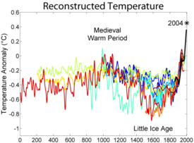
Medieval Warm Period
The Medieval Warm Period , Medieval Climate Optimum, or Medieval Climatic Anomaly was a time of warm climate in the North Atlantic region, that may also have been related to other climate events around the world during that time, including in China, New Zealand, and other countries lasting from...
(Medieval Climate Optimum). While not a true ice age
Ice age
An ice age or, more precisely, glacial age, is a generic geological period of long-term reduction in the temperature of the Earth's surface and atmosphere, resulting in the presence or expansion of continental ice sheets, polar ice sheets and alpine glaciers...
, the term was introduced into the scientific literature by François E. Matthes in 1939. It is conventionally defined as a period extending from the 16th to the 19th centuries, though climatologists and historians working with local records no longer expect to agree on either the start or end dates of this period, which varied according to local conditions. NASA
NASA
The National Aeronautics and Space Administration is the agency of the United States government that is responsible for the nation's civilian space program and for aeronautics and aerospace research...
defines the term as a cold period between 1550 AD and 1850 AD and notes three particularly cold intervals: one beginning about 1650, another about 1770, and the last in 1850, each separated by intervals of slight warming. The Intergovernmental Panel on Climate Change
Intergovernmental Panel on Climate Change
The Intergovernmental Panel on Climate Change is a scientific intergovernmental body which provides comprehensive assessments of current scientific, technical and socio-economic information worldwide about the risk of climate change caused by human activity, its potential environmental and...
(IPCC) describes areas affected by the LIA:
Several causes have been proposed: cyclical lows in solar radiation
Solar variation
Solar variation is the change in the amount of radiation emitted by the Sun and in its spectral distribution over years to millennia. These variations have periodic components, the main one being the approximately 11-year solar cycle . The changes also have aperiodic fluctuations...
, heightened volcanic activity, changes in the ocean circulation, an inherent variability in global climate, or decreases in the human population.
Dating
There is no agreed beginning year of the Little Ice Age, although there is a frequently referenced series of events preceding the known climatic minima. Starting in the 13th century, pack ice began advancing southwards in the North Atlantic, as did glaciers in GreenlandGreenland
Greenland is an autonomous country within the Kingdom of Denmark, located between the Arctic and Atlantic Oceans, east of the Canadian Arctic Archipelago. Though physiographically a part of the continent of North America, Greenland has been politically and culturally associated with Europe for...
. The three years of torrential rains beginning in 1315 ushered in an era of unpredictable weather in Northern Europe
Northern Europe
Northern Europe is the northern part or region of Europe. Northern Europe typically refers to the seven countries in the northern part of the European subcontinent which includes Denmark, Estonia, Latvia, Lithuania, Norway, Finland and Sweden...
, which did not lift until the 19th century. There is anecdotal evidence of expanding glacier
Glacier
A glacier is a large persistent body of ice that forms where the accumulation of snow exceeds its ablation over many years, often centuries. At least 0.1 km² in area and 50 m thick, but often much larger, a glacier slowly deforms and flows due to stresses induced by its weight...
s almost worldwide. In contrast, a climate reconstruction based on glacial length shows no great variation from 1600 to 1850, though it shows strong retreat thereafter.
For this reason, any of several dates ranging over 400 years may indicate the beginning of the Little Ice Age:
- 1250 for when Atlantic pack ice began to grow
- 1300 for when warm summers stopped being dependable in Northern Europe
- 1315 for the rains and Great Famine of 1315-1317
- 1550 for theorized beginning of worldwide glacial expansion
- 1650 for the first climatic minimum.
The prevailing scientific view is that the Little Ice Age ended in the latter half of the 19th century or early in the 20th century. Timothy Ball and Syun-Ichi Akasofu
Syun-Ichi Akasofu
is the Founding Director of the International Arctic Research Center of the University of Alaska Fairbanks , serving in that position from the center's establishment in 1998 until January 2007. Previously he had been director of the university's Geophysical Institute from 1986.-Background:Akasofu...
, founder of the International Arctic Research Center
International Arctic Research Center
The International Arctic Research Center, or IARC, established in 1999, is a research institution focused on integrating and coordinating study of climate change in the Arctic. The primary partners in IARC are Japan and the United States...
at the University of Alaska, believe that Earth's climate is still recovering from the Little Ice Age.
Northern Hemisphere
Europe and North America
The Little Ice Age brought colder winters to parts of EuropeEurope
Europe is, by convention, one of the world's seven continents. Comprising the westernmost peninsula of Eurasia, Europe is generally 'divided' from Asia to its east by the watershed divides of the Ural and Caucasus Mountains, the Ural River, the Caspian and Black Seas, and the waterways connecting...
and North America
North America
North America is a continent wholly within the Northern Hemisphere and almost wholly within the Western Hemisphere. It is also considered a northern subcontinent of the Americas...
. Farms and villages in the Swiss Alps
Swiss Alps
The Swiss Alps are the portion of the Alps mountain range that lies within Switzerland. Because of their central position within the entire Alpine range, they are also known as the Central Alps....
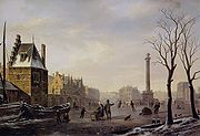
were destroyed by encroaching glaciers during the mid-17th century. Canals and rivers in Great Britain
Great Britain
Great Britain or Britain is an island situated to the northwest of Continental Europe. It is the ninth largest island in the world, and the largest European island, as well as the largest of the British Isles...
and the Netherlands
Netherlands
The Netherlands is a constituent country of the Kingdom of the Netherlands, located mainly in North-West Europe and with several islands in the Caribbean. Mainland Netherlands borders the North Sea to the north and west, Belgium to the south, and Germany to the east, and shares maritime borders...
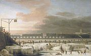
were frequently frozen deeply enough to support ice skating and winter festivals. The first River Thames
River Thames
The River Thames flows through southern England. It is the longest river entirely in England and the second longest in the United Kingdom. While it is best known because its lower reaches flow through central London, the river flows alongside several other towns and cities, including Oxford,...
frost fair was in 1607; the last in 1814, although changes to the bridges and the addition of an embankment
Thames Embankment
The Thames Embankment is a major feat of 19th century civil engineering designed to reclaim marshy land next to the River Thames in central London. It consists of the Victoria and Chelsea Embankment....
affected the river flow and depth, hence diminishing the possibility of freezes. Freezing of the Golden Horn
Golden Horn
The Golden Horn is a historic inlet of the Bosphorus dividing the city of Istanbul and forming the natural harbor that has sheltered Greek, Roman, Byzantine, Ottoman and other ships for thousands of...
and the southern section of the Bosphorus took place in 1622. In 1658, a Swedish
Sweden
Sweden , officially the Kingdom of Sweden , is a Nordic country on the Scandinavian Peninsula in Northern Europe. Sweden borders with Norway and Finland and is connected to Denmark by a bridge-tunnel across the Öresund....
army marched across the Great Belt
March across the Belts
The March across the Belts was a campaign between 30 January and 8 February 1658 during the Second Northern War where Swedish king Karl X Gustav led the Swedish army from Jutland across the ice of the Little Belt and the Great Belt to reach Zealand...
to Denmark
Denmark
Denmark is a Scandinavian country in Northern Europe. The countries of Denmark and Greenland, as well as the Faroe Islands, constitute the Kingdom of Denmark . It is the southernmost of the Nordic countries, southwest of Sweden and south of Norway, and bordered to the south by Germany. Denmark...
to invade Copenhagen
Copenhagen
Copenhagen is the capital and largest city of Denmark, with an urban population of 1,199,224 and a metropolitan population of 1,930,260 . With the completion of the transnational Øresund Bridge in 2000, Copenhagen has become the centre of the increasingly integrating Øresund Region...
. The Baltic Sea
Baltic Sea
The Baltic Sea is a brackish mediterranean sea located in Northern Europe, from 53°N to 66°N latitude and from 20°E to 26°E longitude. It is bounded by the Scandinavian Peninsula, the mainland of Europe, and the Danish islands. It drains into the Kattegat by way of the Øresund, the Great Belt and...
froze over, enabling sledge rides from Poland
Polish-Lithuanian Commonwealth
The Polish–Lithuanian Commonwealth was a dualistic state of Poland and Lithuania ruled by a common monarch. It was the largest and one of the most populous countries of 16th- and 17th‑century Europe with some and a multi-ethnic population of 11 million at its peak in the early 17th century...
to Sweden, with seasonal inns built on the way. The winter of 1794-1795 was particularly harsh, when the French invasion army under Pichegru could march on the frozen rivers of the Netherlands, while the Dutch fleet was fixed in the ice in Den Helder harbour. In the winter of 1780, New York Harbor
New York Harbor
New York Harbor refers to the waterways of the estuary near the mouth of the Hudson River that empty into New York Bay. It is one of the largest natural harbors in the world. Although the U.S. Board of Geographic Names does not use the term, New York Harbor has important historical, governmental,...
froze, allowing people to walk from Manhattan
Manhattan
Manhattan is the oldest and the most densely populated of the five boroughs of New York City. Located primarily on the island of Manhattan at the mouth of the Hudson River, the boundaries of the borough are identical to those of New York County, an original county of the state of New York...
to Staten Island. Sea ice surrounding Iceland
Iceland
Iceland , described as the Republic of Iceland, is a Nordic and European island country in the North Atlantic Ocean, on the Mid-Atlantic Ridge. Iceland also refers to the main island of the country, which contains almost all the population and almost all the land area. The country has a population...
extended for miles in every direction, closing harbors to shipping.

Skeletal fluorosis
Skeletal fluorosis is a bone disease caused by excessive consumption of fluoride. In advanced cases, skeletal fluorosis causes pain and damage to bones and joints.-Forms:...
after the eruption of the volcano Laki
Laki
Łąki may refer to the following places in Poland:*Łąki, Lower Silesian Voivodeship *Łąki, West Pomeranian Voivodeship *Łąki, Lublin Voivodeship...
in 1783. Iceland also suffered failures of cereal crops, and people moved away from a grain-based diet.
The Norse colonies
Norse colonization of the Americas
The Norse colonization of the Americas began as early as the 10th century, when Norse sailors explored and settled areas of the North Atlantic, including the northeastern fringes of North America....
in Greenland
Greenland
Greenland is an autonomous country within the Kingdom of Denmark, located between the Arctic and Atlantic Oceans, east of the Canadian Arctic Archipelago. Though physiographically a part of the continent of North America, Greenland has been politically and culturally associated with Europe for...
starved and vanished (by the 15th century), as crops failed and livestock could not be maintained through increasingly harsh winters, though Jared Diamond
Jared Diamond
Jared Mason Diamond is an American scientist and author whose work draws from a variety of fields. He is currently Professor of Geography and Physiology at UCLA...
noted that they had exceeded the agricultural carrying capacity before then. In North America, American Indians formed leagues in response to food shortages.
In Portugal
Portugal
Portugal , officially the Portuguese Republic is a country situated in southwestern Europe on the Iberian Peninsula. Portugal is the westernmost country of Europe, and is bordered by the Atlantic Ocean to the West and South and by Spain to the North and East. The Atlantic archipelagos of the...
, snowstorms were much more frequent than today. There are reports of heavy snowfalls in the winters of 1665, 1744 and 1886.
Great Famine of 1315–1317
The Great Famine of 1315–1317 was the first of a series of large scale crises that struck Northern Europe early in the fourteenth century...
, although this may have been before the LIA proper). According to Elizabeth Ewan and Janay Nugent, "Famine
Famine
A famine is a widespread scarcity of food, caused by several factors including crop failure, overpopulation, or government policies. This phenomenon is usually accompanied or followed by regional malnutrition, starvation, epidemic, and increased mortality. Every continent in the world has...
s in France 1693-94, Norway 1695-96 and Sweden 1696-97 claimed roughly 10% of the population of each country. In Estonia and Finland in 1696-97, losses have been estimated at a fifth and a third of the national populations, respectively." Viticulture
Viticulture
Viticulture is the science, production and study of grapes which deals with the series of events that occur in the vineyard. When the grapes are used for winemaking, it is also known as viniculture...
disappeared from some northern regions. Violent storms caused massive flooding and loss of life. Some of these resulted in permanent loss of large areas of land from the Danish, German and Dutch coasts.
The extent of mountain glaciers had been mapped by the late 19th century. In both the north and the south temperate zones, snowlines (the boundaries separating zones of net accumulation from those of net ablation) were about 100 m lower than they were in 1975. In Glacier National Park, the last episode of glacier advance came in the late 18th and early 19th centuries. In Chesapeake Bay
Chesapeake Bay
The Chesapeake Bay is the largest estuary in the United States. It lies off the Atlantic Ocean, surrounded by Maryland and Virginia. The Chesapeake Bay's drainage basin covers in the District of Columbia and parts of six states: New York, Pennsylvania, Delaware, Maryland, Virginia, and West...
, Maryland
Maryland
Maryland is a U.S. state located in the Mid Atlantic region of the United States, bordering Virginia, West Virginia, and the District of Columbia to its south and west; Pennsylvania to its north; and Delaware to its east...
, large temperature excursions were possibly related to changes in the strength of North Atlantic thermohaline circulation
Thermohaline circulation
The term thermohaline circulation refers to a part of the large-scale ocean circulation that is driven by global density gradients created by surface heat and freshwater fluxes....
.
In Ethiopia
Ethiopia
Ethiopia , officially known as the Federal Democratic Republic of Ethiopia, is a country located in the Horn of Africa. It is the second-most populous nation in Africa, with over 82 million inhabitants, and the tenth-largest by area, occupying 1,100,000 km2...
and Mauritania
Mauritania
Mauritania is a country in the Maghreb and West Africa. It is bordered by the Atlantic Ocean in the west, by Western Sahara in the north, by Algeria in the northeast, by Mali in the east and southeast, and by Senegal in the southwest...
, permanent snow was reported on mountain peaks at levels where it does not occur today. Timbuktu
Timbuktu
Timbuktu , formerly also spelled Timbuctoo, is a town in the West African nation of Mali situated north of the River Niger on the southern edge of the Sahara Desert. The town is the capital of the Timbuktu Region, one of the eight administrative regions of Mali...
, an important city on the trans-Sahara
Sahara
The Sahara is the world's second largest desert, after Antarctica. At over , it covers most of Northern Africa, making it almost as large as Europe or the United States. The Sahara stretches from the Red Sea, including parts of the Mediterranean coasts, to the outskirts of the Atlantic Ocean...
n caravan route, was flooded at least 13 times by the Niger River
Niger River
The Niger River is the principal river of western Africa, extending about . Its drainage basin is in area. Its source is in the Guinea Highlands in southeastern Guinea...
; there are no records of similar flooding before or since. In China
China
Chinese civilization may refer to:* China for more general discussion of the country.* Chinese culture* Greater China, the transnational community of ethnic Chinese.* History of China* Sinosphere, the area historically affected by Chinese culture...
, warm weather crops such as oranges were abandoned in Jiangxi Province, where they had been grown for centuries. Also, two periods of most frequent typhoon strikes in Guangdong
Guangdong
Guangdong is a province on the South China Sea coast of the People's Republic of China. The province was previously often written with the alternative English name Kwangtung Province...
coincide with two of the coldest and driest periods in northern and central China (AD 1660-1680, 1850–1880). In North America, the early European settlers reported exceptionally severe winters. For example, in 1607-1608, ice persisted on Lake Superior
Lake Superior
Lake Superior is the largest of the five traditionally-demarcated Great Lakes of North America. It is bounded to the north by the Canadian province of Ontario and the U.S. state of Minnesota, and to the south by the U.S. states of Wisconsin and Michigan. It is the largest freshwater lake in the...
until June. The journal of Pierre de Troyes, Chevalier de Troyes
Pierre de Troyes, Chevalier de Troyes
Pierre de Troyes, Chevalier de Troyes , a captain in the French army arrived at Quebec in August 1685 with reinforcements for the colony...
, who led an expedition to James Bay
James Bay
James Bay is a large body of water on the southern end of Hudson Bay in Canada. Both bodies of water extend from the Arctic Ocean. James Bay borders the provinces of Quebec and Ontario; islands within the bay are part of Nunavut...
in 1686, recorded that James Bay was still littered with so much floating ice that he could hide behind it in his canoe on July 1.
Antonio Stradivari
Antonio Stradivari
Antonio Stradivari was an Italian luthier and a crafter of string instruments such as violins, cellos, guitars, violas, and harps. Stradivari is generally considered the most significant artisan in this field. The Latinized form of his surname, Stradivarius, as well as the colloquial, "Strad", is...
, the famous violin maker, produced his instruments during the Little Ice Age. It has been proposed that the colder climate caused the wood used in his violins to be denser than in warmer periods, contributing to the tone of Stradivari's instruments.
The Little Ice Age by anthropology professor Brian Fagan
Brian Fagan
Brian Murray Fagan is a prolific author of popular archaeology books and a professor emeritus of Anthropology at the University of California, Santa Barbara, California, USA.-Biography:...
of the University of California at Santa Barbara tells of the plight of European peasants during the 1300 to 1850 chill: famine
Famine
A famine is a widespread scarcity of food, caused by several factors including crop failure, overpopulation, or government policies. This phenomenon is usually accompanied or followed by regional malnutrition, starvation, epidemic, and increased mortality. Every continent in the world has...
s, hypothermia
Hypothermia
Hypothermia is a condition in which core temperature drops below the required temperature for normal metabolism and body functions which is defined as . Body temperature is usually maintained near a constant level of through biologic homeostasis or thermoregulation...
, bread riots, and the rise of despotic leaders brutalizing an increasingly dispirited peasantry. In the late 17th century, writes Fagan, agriculture had dropped off so dramatically that "Alpine villagers lived on bread made from ground nutshells mixed with barley and oat flour." Historian Wolfgang Behringer has linked intensive witch-hunting episodes in Europe to agricultural failures during the Little Ice Age.
Depictions of winter in European painting
Burroughs analyzes the depiction of winter in paintings, as does Hans NeubergerHans Neuberger
Hans Hermann Neuberger was head of Pennsylvania State University's Department of Meteorology.Born in Mannheim, Germany, he received a doctorate from the University of Hamburg in 1936 and emigrated to the US in 1937, beginning his career as an instructor of geophysics. His skills in the creation...
. Burroughs asserts that this occurred almost entirely from 1565 to 1665 and was associated with the climatic decline from 1550 onwards. Before this, there were almost no depictions of winter in art, and he hypothesizes that the unusually harsh winter of 1565 inspired great artists to depict highly original images and that the decline in such paintings was a combination of the "theme" having been fully explored and mild winters interrupting the flow of painting.
The famous winter paintings by Pieter Brueghel the Elder
Pieter Brueghel the Elder
Pieter Bruegel the Elder was a Flemish renaissance painter and printmaker known for his landscapes and peasant scenes . He is sometimes referred to as the "Peasant Bruegel" to distinguish him from other members of the Brueghel dynasty, but he is also the one generally meant when the context does...
(e.g. Hunters in the Snow) all appear to have been painted in 1565. Snow also dominates many village-scapes by Pieter Brueghel the Younger
Pieter Brueghel the Younger
Pieter Brueghel the Younger /ˈpitəɾ ˈbɾøːxəl/ was a Flemish painter, known for numerous copies after his father Pieter Brueghel the Elder's paintings and nicknamed "Hell Brueghel" for his fantastic treatments of fire and grotesque imagery.-Life:Pieter Brueghel the Younger was the oldest son of the...
, who lived from 1564 to 1638. Burroughs states that Pieter Brueghel the Younger "slavishly copied his father's designs. The derivative nature of so much of this work makes it difficult to draw any definite conclusions about the influence of the winters between 1570 and 1600..."

Hendrick Avercamp
Hendrick Avercamp was a Dutch painter.Avercamp was born in Amsterdam, where he studied with the Danish-born portrait painter Pieter Isaacks , and perhaps also with David Vinckboons. In 1608 he moved from Amsterdam to Kampen in the province of Overijssel...
after the winter of 1608. There is then an interruption of the theme between 1627 and 1640, with a sudden return thereafter; this hints at a milder interlude in the 1630s. The 1640s to the 1660s cover the major period of Dutch winter painting, which fits with the known proportion of cold winters then. The final decline in winter painting, around 1660, does not coincide with an amelioration of the climate; Burroughs therefore cautions against trying to read too much into artistic output, since fashion plays a part. He notes that winter painting recurs around the 1780s and 1810s, which again marked a colder period.
Neuberger analyzed 12,000 paintings, held in American and European museums and dated between 1400 and 1967, for cloudiness and darkness. His 1970 publication shows an increase in such depictions that corresponds to the LIA, peaking between 1600 and 1649.
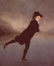
Paintings and contemporary records in Scotland
Scotland
Scotland is a country that is part of the United Kingdom. Occupying the northern third of the island of Great Britain, it shares a border with England to the south and is bounded by the North Sea to the east, the Atlantic Ocean to the north and west, and the North Channel and Irish Sea to the...
demonstrate that curling
Curling
Curling is a sport in which players slide stones across a sheet of ice towards a target area. It is related to bowls, boule and shuffleboard. Two teams, each of four players, take turns sliding heavy, polished granite stones, also called "rocks", across the ice curling sheet towards the house, a...
and ice skating
Ice skating
Ice skating is moving on ice by using ice skates. It can be done for a variety of reasons, including leisure, traveling, and various sports. Ice skating occurs both on specially prepared indoor and outdoor tracks, as well as on naturally occurring bodies of frozen water, such as lakes and...
were popular outdoor winter sports, with curling dating back to the 16th century and becoming widely popular in the mid-19th century. As an example, an outdoor curling pond constructed in Gourock
Gourock
Gourock is a town falling within the Inverclyde council area and formerly forming a burgh of the historic county of Renfrewshire in the west central Lowlands of Scotland. It has in the past functioned as a seaside resort on the Firth of Clyde...
in the 1860s remained in use for almost a century, but increasing use of indoor facilities, problems of vandalism, and milder winters led to the pond being abandoned in 1963.
Central America
An analysis of several proxies undertaken in Mexico's Yucatan PeninsulaYucatán Peninsula
The Yucatán Peninsula, in southeastern Mexico, separates the Caribbean Sea from the Gulf of Mexico, with the northern coastline on the Yucatán Channel...
, linked by its authors to Maya
Maya civilization
The Maya is a Mesoamerican civilization, noted for the only known fully developed written language of the pre-Columbian Americas, as well as for its art, architecture, and mathematical and astronomical systems. Initially established during the Pre-Classic period The Maya is a Mesoamerican...
n and Aztec
Aztec
The Aztec people were certain ethnic groups of central Mexico, particularly those groups who spoke the Nahuatl language and who dominated large parts of Mesoamerica in the 14th, 15th and 16th centuries, a period referred to as the late post-classic period in Mesoamerican chronology.Aztec is the...
chronicles relating periods of cold and drought, supports the existence of the Little Ice Age in the region.
Southern Hemisphere
Since the discovery of the Little Ice Age, there have been doubts about whether it was a global phenomenon or a cold spell restricted to the Northern Hemisphere. In recent years, several scientific works have pointed out the existence of cold spells and climate changes in areas of the Southern Hemisphere and their correlation to the Little Ice Age.Africa
In Southern AfricaSouthern Africa
Southern Africa is the southernmost region of the African continent, variably defined by geography or geopolitics. Within the region are numerous territories, including the Republic of South Africa ; nowadays, the simpler term South Africa is generally reserved for the country in English.-UN...
, sediment cores retrieved from Lake Malawi
Lake Malawi
Lake Malawi , is an African Great Lake and the southernmost lake in the Great Rift Valley system of East Africa. This lake, the third largest in Africa and the eighth largest lake in the world, is located between Malawi, Mozambique, and Tanzania...
show colder conditions between 1570 and 1820, suggesting the Lake Malawi records "further support, and extend, the global expanse of the Little Ice Age."
A novel 3,000-year temperature reconstruction method based on the rate of stalagmite
Stalagmite
A stalagmite is a type of speleothem that rises from the floor of a limestone cave due to the dripping of mineralized solutions and the deposition of calcium carbonate. This stalagmite formation occurs only under certain pH conditions within the underground cavern. The corresponding formation on...
growth in a cold cave in South Africa
South Africa
The Republic of South Africa is a country in southern Africa. Located at the southern tip of Africa, it is divided into nine provinces, with of coastline on the Atlantic and Indian oceans...
suggests a cold period from 1500 to 1800 "characterizing the South African Little Ice age."
Antarctica
Kreutz et al. (1997) compared results from studies of West Antarctic ice cores with the Greenland Ice Sheet Project Two (GISP2) and suggested a synchronous global Little Ice Age.An ocean sediment core from the eastern Bransfield Basin in the Antarctic Peninsula
Antarctic Peninsula
The Antarctic Peninsula is the northernmost part of the mainland of Antarctica. It extends from a line between Cape Adams and a point on the mainland south of Eklund Islands....
shows centennial events that the authors link to the Little Ice Age and Medieval Warm Period. The authors note "other unexplained climatic events comparable in duration and amplitude to the LIA and MWP events also appear."
The Siple Dome
Siple Dome
Siple Dome is an ice dome approximately 100 km wide and 100 km long, located 130 km east of Siple Coast. Charles Bentley and Robert Thomas established a "strain rosette" on this feature to determine ice movement in 1973-74. They referred to the feature as Siple Dome because of its...
(SD) has a climate event with an onset time that is coincident with that of the LIA in the North Atlantic based on a correlation with the GISP2 record. This event is the most dramatic climate event seen in the SD Holocene glaciochemical record. The Siple Dome ice core also contained its highest rate of melt layers (up to 8%) between 1550 and 1700, most likely because of warm summers during the LIA.
Law Dome
Law Dome
Law Dome is a large ice dome which rises to 1,395 m directly south of Cape Poinsett, Antarctica. The feature was roughly mapped by the United States Geological Survey from aerial photographs taken by USN Operation Highjump, 1946-47...
ice cores show lower levels of CO2 mixing ratios during 1550-1800 AD, leading investigators Etheridge and Steele to conjecture "probably as a result of colder global climate."
Sediment cores in Bransfield Basin, Antarctic Peninsula, have neoglacial indicators by diatom
Diatom
Diatoms are a major group of algae, and are one of the most common types of phytoplankton. Most diatoms are unicellular, although they can exist as colonies in the shape of filaments or ribbons , fans , zigzags , or stellate colonies . Diatoms are producers within the food chain...
and sea-ice taxa variations during the period of the LIA.
Australia, New Zealand and Pacific Islands
There is limited evidence about conditions in AustraliaClimate change in Australia
Climate change has become a major issue in Australia due to drastic climate events since the turn of the 21st century that have focused government and public attention. Rainfall in Australia has increased slightly over the past century, although there is little or no trend in rainfall in northeast...
, though lake records in Victoria
Victoria (Australia)
Victoria is the second most populous state in Australia. Geographically the smallest mainland state, Victoria is bordered by New South Wales, South Australia, and Tasmania on Boundary Islet to the north, west and south respectively....
suggest that conditions, at least in the south of the state, were wet and/or unusually cool. In the north of the continent, the limited evidence suggests fairly dry conditions, while coral cores from the Great Barrier Reef
Great Barrier Reef
The Great Barrier Reef is the world'slargest reef system composed of over 2,900 individual reefs and 900 islands stretching for over 2,600 kilometres over an area of approximately...
show similar rainfall as today but with less variability. A study that analyzed isotope
Isotope
Isotopes are variants of atoms of a particular chemical element, which have differing numbers of neutrons. Atoms of a particular element by definition must contain the same number of protons but may have a distinct number of neutrons which differs from atom to atom, without changing the designation...
s in Great Barrier Reef corals suggested that increased water vapor transport from southern tropical oceans to the poles contributed to the LIA.
Sea-level data for the Pacific Islands suggest that sea level in the region fell, possibly in two stages, between AD 1270-1475. This was associated with a 1.5°C fall in temperature (determined from oxygen-isotope analysis) and an observed increase in El Niño frequency.
Borehole reconstructions from Australia suggest that, over the last 500 years, the 17th century was the coldest in that continent, although the borehole temperature reconstruction method does not show good agreement between the Northern and Southern Hemispheres.
On the west coast of the Southern Alps
Southern Alps
The Southern Alps is a mountain range extending along much of the length of New Zealand's South Island, reaching its greatest elevations near the island's western side...
of New Zealand
New Zealand
New Zealand is an island country in the south-western Pacific Ocean comprising two main landmasses and numerous smaller islands. The country is situated some east of Australia across the Tasman Sea, and roughly south of the Pacific island nations of New Caledonia, Fiji, and Tonga...
, the Franz Josef glacier
Franz Josef Glacier
The Franz Josef is a long glacier located in Westland Tai Poutini National Park on the West Coast of New Zealand's South Island...
advanced rapidly during the Little Ice Age, reaching its maximum extent in the early 18th century, in one of the few places where a glacier thrust into a rain forest. Based on dating of a yellow-green lichen of the Rhizocarpon subgenus, the Mueller Glacier
Mueller Glacier
The Mueller Glacier is a long glacier flowing through Aoraki/Mount Cook National Park in the South Island of New Zealand. It lies to the south of Aoraki/Mount Cook, high in the Southern Alps, and flows north...
, on the eastern flank of the Southern Alps within Aoraki/Mount Cook National Park
Aoraki/Mount Cook National Park
Aoraki/Mount Cook National Park is in the South Island of New Zealand near the town of Twizel. Aoraki/Mount Cook, New Zealand's highest mountain and Aoraki/Mount Cook village lie within the park...
, is considered to have been at its maximum extent between 1725 and 1730.
South America
Tree-ring data from PatagoniaPatagonia
Patagonia is a region located in Argentina and Chile, integrating the southernmost section of the Andes mountains to the southwest towards the Pacific ocean and from the east of the cordillera to the valleys it follows south through Colorado River towards Carmen de Patagones in the Atlantic Ocean...
show cold episodes between 1270 and 1380 and from 1520 to 1670, periods contemporary with LIA events in the Northern Hemisphere. Eight sediment cores taken from Puyehue Lake
Puyehue Lake
Puyehue Lake is an Andean piedmont lake located in the border of Los Lagos Region with Los Ríos Region of Chile...
have been interpreted as showing a humid period from 1470 to 1700, which the authors describe as a regional marker of LIA onset. A 2009 paper details cooler and wetter conditions in southeastern South America between 1550 and 1800 AD, citing evidence obtained via several proxies and models.
Although it only provides anecdotal evidence, in 1675, the Spanish explorer Antonio de Vea entered San Rafael Lagoon
San Rafael Lagoon
San Rafael Lagoon is an arc-shaped coastal lake located in the Aisén Region of Chile, within the national park that bears its name. To the north the lagoon is connected to the Moraleda Channel, to the south lies the Ofqui Isthmus...
through Río Témpanos (Spanish for "Ice Floe River") without mentioning any ice floe and stated that the San Rafael Glacier
San Rafael Glacier
The San Rafael Glacier is one of the major outlet glaciers of the Northern Patagonian Ice Field in southern Chile and is the tidewater glacier nearest the equator. It calves into the Laguna San Rafael and is contained within Laguna San Rafael National Park....
did not reach far into the lagoon. In 1766, another expedition noticed that the glacier did reach the lagoon and calved
Ice calving
Ice calving, also known as glacier calving or iceberg calving, is a form of ice ablation or ice disruption. It is the sudden release and breaking away of a mass of ice from a glacier, iceberg, ice front, ice shelf, or crevasse...
into large icebergs. Hans Steffen
Hans Steffen
right|thumb|200px|Picture of Hans Steffen in 1916Hans Steffen Hoffman was a German geographer and explorer of Aysén Region in western Patagonia. Steffen did also work as teacher, encyclopedist and historian...
visited the area in 1898, noticing that the glacier penetrated far into the lagoon. Such historical records indicate a general cooling in the area between 1675 and 1898, and "The recognition of the LIA in northern Patagonia, through the use of documentary sources, provides important, independent evidence for the occurrence of this phenomenon in the region." As of 2001, the border of the glacier has significantly retreated compared to the borders of 1675.
Climate patterns
In the North Atlantic, sediments accumulated since the end of the last ice age, nearly 12,000 years ago, show regular increases in the amount of coarse sediment grains deposited from icebergs melting in the now open ocean, indicating a series of 1-2°C (2-4°F) cooling events recurring every 1,500 years or so. The most recent of these cooling events was the Little Ice Age. These same cooling events are detected in sediments accumulating off Africa, but the cooling events appear to be larger, ranging between 3-8°C (6-14°F).Causes
Scientists have tentatively identified these possible causes of the Little Ice Age: orbital cyclesOrbital forcing
Orbital forcing is the effect on climate of slow changes in the tilt of the Earth's axis and shape of the orbit . These orbital changes change the total amount of sunlight reaching the Earth by up to 25% at mid-latitudes...
, decreased solar activity
Solar variation
Solar variation is the change in the amount of radiation emitted by the Sun and in its spectral distribution over years to millennia. These variations have periodic components, the main one being the approximately 11-year solar cycle . The changes also have aperiodic fluctuations...
, increased volcanic activity, altered ocean current flows, the inherent variability of global climate, and reforestation following decreases in the human population.
Orbital cycles
Orbital forcingOrbital forcing
Orbital forcing is the effect on climate of slow changes in the tilt of the Earth's axis and shape of the orbit . These orbital changes change the total amount of sunlight reaching the Earth by up to 25% at mid-latitudes...
due to cycles in the earth's orbit around the sun has, for the past 2,000 years, caused a long-term cooling trend that continued through the Medieval period and the Little Ice Age. The rate of Arctic
Arctic
The Arctic is a region located at the northern-most part of the Earth. The Arctic consists of the Arctic Ocean and parts of Canada, Russia, Greenland, the United States, Norway, Sweden, Finland, and Iceland. The Arctic region consists of a vast, ice-covered ocean, surrounded by treeless permafrost...
cooling is roughly 0.02 degrees Celsius per century. This trend would be expected to continue for a further 4,000 years and lead to a full ice age
Ice age
An ice age or, more precisely, glacial age, is a generic geological period of long-term reduction in the temperature of the Earth's surface and atmosphere, resulting in the presence or expansion of continental ice sheets, polar ice sheets and alpine glaciers...
, but the 20th-century instrumental temperature record
Instrumental temperature record
The instrumental temperature record shows fluctuations of the temperature of the global land surface and oceans. This data is collected from several thousand meteorological stations, Antarctic research stations and satellite observations of sea-surface temperature. Currently, the longest-running...
shows a sudden rise in global temperatures attributed to greenhouse gas
Greenhouse gas
A greenhouse gas is a gas in an atmosphere that absorbs and emits radiation within the thermal infrared range. This process is the fundamental cause of the greenhouse effect. The primary greenhouse gases in the Earth's atmosphere are water vapor, carbon dioxide, methane, nitrous oxide, and ozone...
emissions.
Solar activity

Sunspot
Sunspots are temporary phenomena on the photosphere of the Sun that appear visibly as dark spots compared to surrounding regions. They are caused by intense magnetic activity, which inhibits convection by an effect comparable to the eddy current brake, forming areas of reduced surface temperature....
activity and cooling temperatures.
During the period 1645–1715, in the middle of the Little Ice Age, there was a period of low solar activity known as the Maunder Minimum
Maunder Minimum
The Maunder Minimum is the name used for the period roughly spanning 1645 to 1715 when sunspots became exceedingly rare, as noted by solar observers of the time....
.
The Spörer Minimum
Spörer Minimum
The Spörer Minimum was a 90-year span of low solar activity, from about 1460 until 1550, which was identified and named by John A. Eddy in a landmark 1976 paper published in Science titled "The Maunder Minimum"...
has also been identified with a significant cooling period between 1460 and 1550.
Other indicators of low solar activity during this period are levels of the isotopes carbon-14
Carbon-14
Carbon-14, 14C, or radiocarbon, is a radioactive isotope of carbon with a nucleus containing 6 protons and 8 neutrons. Its presence in organic materials is the basis of the radiocarbon dating method pioneered by Willard Libby and colleagues , to date archaeological, geological, and hydrogeological...
and beryllium-10
Ice core
An ice core is a core sample that is typically removed from an ice sheet, most commonly from the polar ice caps of Antarctica, Greenland or from high mountain glaciers elsewhere. As the ice forms from the incremental build up of annual layers of snow, lower layers are older than upper, and an ice...
.
Volcanic activity
Throughout the Little Ice Age, the world experienced heightened volcanic activity. When a volcanoVolcano
2. Bedrock3. Conduit 4. Base5. Sill6. Dike7. Layers of ash emitted by the volcano8. Flank| 9. Layers of lava emitted by the volcano10. Throat11. Parasitic cone12. Lava flow13. Vent14. Crater15...
erupts, its ash reaches high into the atmosphere and can spread to cover the whole earth. This ash cloud blocks out some of the incoming solar radiation, leading to worldwide cooling that can last up to two years after an eruption. Also emitted by eruptions is sulfur
Sulfur
Sulfur or sulphur is the chemical element with atomic number 16. In the periodic table it is represented by the symbol S. It is an abundant, multivalent non-metal. Under normal conditions, sulfur atoms form cyclic octatomic molecules with chemical formula S8. Elemental sulfur is a bright yellow...
in the form of SO2 gas. When this gas reaches the stratosphere
Stratosphere
The stratosphere is the second major layer of Earth's atmosphere, just above the troposphere, and below the mesosphere. It is stratified in temperature, with warmer layers higher up and cooler layers farther down. This is in contrast to the troposphere near the Earth's surface, which is cooler...
, it turns into sulfuric acid
Sulfuric acid
Sulfuric acid is a strong mineral acid with the molecular formula . Its historical name is oil of vitriol. Pure sulfuric acid is a highly corrosive, colorless, viscous liquid. The salts of sulfuric acid are called sulfates...
particles, which reflect the sun's rays, further reducing the amount of radiation reaching Earth's surface. The 1815 eruption of Tambora
Mount Tambora
Mount Tambora is an active stratovolcano, also known as a composite volcano, on the island of Sumbawa, Indonesia. Sumbawa is flanked both to the north and south by oceanic crust, and Tambora was formed by the active subduction zone beneath it. This raised Mount Tambora as high as , making it...
in Indonesia
Indonesia
Indonesia , officially the Republic of Indonesia , is a country in Southeast Asia and Oceania. Indonesia is an archipelago comprising approximately 13,000 islands. It has 33 provinces with over 238 million people, and is the world's fourth most populous country. Indonesia is a republic, with an...
blanketed the atmosphere with ash; the following year, 1816, came to be known as the Year Without a Summer
Year Without a Summer
The Year Without a Summer was 1816, in which severe summer climate abnormalities caused average global temperatures to decrease by about 0.4–0.7 °C , resulting in major food shortages across the Northern Hemisphere...
, when frost
Frost
Frost is the solid deposition of water vapor from saturated air. It is formed when solid surfaces are cooled to below the dew point of the adjacent air as well as below the freezing point of water. Frost crystals' size differ depending on time and water vapour available. Frost is also usually...
and snow were reported in June and July in both New England
New England
New England is a region in the northeastern corner of the United States consisting of the six states of Maine, New Hampshire, Vermont, Massachusetts, Rhode Island, and Connecticut...
and Northern Europe. Other volcanoes that erupted during the era and may have contributed to the cooling include Billy Mitchell
Billy Mitchell (volcano)
Billy Mitchell is a volcano located in the central part of the island of Bougainville, just northeast of the Bagana Volcano, in Papua New Guinea. It is a small, pyroclastic shield truncated by a 2 km wide caldera filled by a crater lake....
(ca. 1580), Mount Parker
Mount Parker (Cotabato)
Mount Parker, locally known as Melibengoy, is a stratovolcano on Mindanao island in the Philippines . It is located in the province of South Cotabato, 30 kilometers west of General Santos City and 44 kilometers south of Koronadal City.The volcano's English name is taken from an American...
(1641), Long Island (Papua New Guinea) (ca. 1660), and Huaynaputina
Huaynaputina
Huaynaputina is a stratovolcano located in a volcanic upland in southern Peru. The volcano does not have an identifiable mountain profile, but instead has the form of a large volcanic crater. It has produced high-potassium andesite and dacite...
(1600).
Ocean Conveyor slowdown
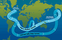
Thermohaline circulation
The term thermohaline circulation refers to a part of the large-scale ocean circulation that is driven by global density gradients created by surface heat and freshwater fluxes....
. The circulation could have been interrupted by the introduction of a large amount of fresh water into the North Atlantic, possibly caused by a period of warming before the Little Ice Age known as the Medieval Warm Period
Medieval Warm Period
The Medieval Warm Period , Medieval Climate Optimum, or Medieval Climatic Anomaly was a time of warm climate in the North Atlantic region, that may also have been related to other climate events around the world during that time, including in China, New Zealand, and other countries lasting from...
. There is some concern that a shutdown of thermohaline circulation
Shutdown of thermohaline circulation
Shutdown or slowdown of the thermohaline circulation is a postulated effect of global warming.There is some speculation that global warming could, via a shutdown or slowdown of the thermohaline circulation, trigger localised cooling in the North Atlantic and lead to cooling, or lesser warming, in...
could happen again as a result of the present warming period.
Decreased human populations
Some researchers have proposed that human influences on climate began earlier than is normally supposed and that major population declines in Eurasia and the Americas reduced this impact, leading to a cooling trend. William RuddimanWilliam Ruddiman
William F. Ruddiman is a palaeoclimatologist and Professor Emeritus at the University of Virginia. Ruddiman earned an undergraduate degree in geology in 1964 at Williams College, and a Ph.D. in marine geology from Columbia University in 1969. Ruddiman worked at the US Naval Oceanographic Office...
has proposed that somewhat reduced populations of Europe, East Asia, and the Middle East during and after the Black Death
Black Death
The Black Death was one of the most devastating pandemics in human history, peaking in Europe between 1348 and 1350. Of several competing theories, the dominant explanation for the Black Death is the plague theory, which attributes the outbreak to the bacterium Yersinia pestis. Thought to have...
caused a decrease in agricultural activity. He suggests reforestation took place, allowing more carbon dioxide uptake from the atmosphere, which may have been a factor in the cooling noted during the Little Ice Age. Ruddiman further hypothesizes that a reduced population in the Americas after European contact in the early 16th century could have had a similar effect. A 2008 study of sediment cores and soil samples further suggests that carbon dioxide uptake via reforestation in the Americas could have contributed to the Little Ice Age. Faust, Gnecco, Mannstein and Stamm (2005) supported depopulation in the Americas as a factor, asserting that humans had cleared considerable amounts of forests to support agriculture in the Americas before the arrival of Europeans brought on a population collapse. The authors link the subsequent depopulation to a drop in carbon dioxide levels observed at Law Dome
Law Dome
Law Dome is a large ice dome which rises to 1,395 m directly south of Cape Poinsett, Antarctica. The feature was roughly mapped by the United States Geological Survey from aerial photographs taken by USN Operation Highjump, 1946-47...
, Antarctica.
Inherent variability of climate
Spontaneous fluctuations in global climate might explain past variability. However, it is very difficult to know what the true level of variability from only internal causes might be, since other forcings, as noted above, exist; and their magnitude may not be known either. One approach to evaluating internal variability is to use long integrations of coupled ocean-atmosphere global climate modelGlobal climate model
A General Circulation Model is a mathematical model of the general circulation of a planetary atmosphere or ocean and based on the Navier–Stokes equations on a rotating sphere with thermodynamic terms for various energy sources . These equations are the basis for complex computer programs commonly...
s. These have the advantage that the external forcing is known to be zero; but the disadvantage is that they may not fully reflect reality. These variations may result from chaos
Chaos theory
Chaos theory is a field of study in mathematics, with applications in several disciplines including physics, economics, biology, and philosophy. Chaos theory studies the behavior of dynamical systems that are highly sensitive to initial conditions, an effect which is popularly referred to as the...
-driven changes in the oceans, the atmosphere, or interactions between the two. Two studies have concluded that the demonstrated inherent variability is not great enough to account for the Little Ice Age.
See also
- 1500-year climate cycle
- 8.2 kiloyear event8.2 kiloyear eventThe 8.2 kiloyear event is the term that climatologists have adopted for a sudden decrease in global temperatures that occurred approximately 8,200 years before the present, or c. 6,200 BCE, and which lasted for the next two to four centuries...
- Global coolingGlobal coolingGlobal cooling was a conjecture during the 1970s of imminent cooling of the Earth's surface and atmosphere along with a posited commencement of glaciation...
- Historical climatologyHistorical climatologyHistorical climatology is the study of historical changes in climate and their effect on human history and development. This differs from paleoclimatology which encompasses climate change over the entire history of the earth. The study seeks to define periods in human history where temperature or...
- Maunder MinimumMaunder MinimumThe Maunder Minimum is the name used for the period roughly spanning 1645 to 1715 when sunspots became exceedingly rare, as noted by solar observers of the time....
- Medieval Warm PeriodMedieval Warm PeriodThe Medieval Warm Period , Medieval Climate Optimum, or Medieval Climatic Anomaly was a time of warm climate in the North Atlantic region, that may also have been related to other climate events around the world during that time, including in China, New Zealand, and other countries lasting from...
- PaleoclimatologyPaleoclimatologyPaleoclimatology is the study of changes in climate taken on the scale of the entire history of Earth. It uses a variety of proxy methods from the Earth and life sciences to obtain data previously preserved within rocks, sediments, ice sheets, tree rings, corals, shells and microfossils; it then...
- Retreat of glaciers since 1850Retreat of glaciers since 1850The retreat of glaciers since 1850 affects the availability of fresh water for irrigation and domestic use, mountain recreation, animals and plants that depend on glacier-melt, and in the longer term, the level of the oceans...
- Shutdown of thermohaline circulationShutdown of thermohaline circulationShutdown or slowdown of the thermohaline circulation is a postulated effect of global warming.There is some speculation that global warming could, via a shutdown or slowdown of the thermohaline circulation, trigger localised cooling in the North Atlantic and lead to cooling, or lesser warming, in...
- Younger DryasYounger DryasThe Younger Dryas stadial, also referred to as the Big Freeze, was a geologically brief period of cold climatic conditions and drought between approximately 12.8 and 11.5 ka BP, or 12,800 and 11,500 years before present...
Further reading
- Brian FaganBrian FaganBrian Murray Fagan is a prolific author of popular archaeology books and a professor emeritus of Anthropology at the University of California, Santa Barbara, California, USA.-Biography:...
, 2000, The Little Ice Age: How Climate Made History, 1300-1850. Basic Books. ISBN 0-465-02272-3.
External links
- Abrupt Climate Change Information from the Ocean & Climate Change Institute, links to Woods Hole Oceanographic InstitutionWoods Hole Oceanographic InstitutionThe Woods Hole Oceanographic Institution is a private, nonprofit research and higher education facility dedicated to the study of all aspects of marine science and engineering and to the education of marine researchers. Established in 1930, it is the largest independent oceanographic research...
articles - The Next Ice Age, DiscoverDiscover (magazine)Discover is an American science magazine that publishes articles about science for a general audience. The monthly magazine was launched in October 1980 by Time Inc. It was sold to Family Media, the owners of Health, in 1987. Walt Disney Company bought the magazine when Family Media went out of...
, September 2002 (discussion of Woods Hole research) - Huascaran (Peru) Ice Core Data from the NOAA/NGDC Paleoclimatology Program, 1995
- Dansgaard cycles and the Little Ice Age (LIA) (It is not easy to see a LIA in the graphs.)
- The Little Ice Age and Medieval Warming in South Africa (abstract)
- Was El Niño unaffected by the Little Ice Age? (2002)
- Evidence for the Little Ice Age in Spain, circa 2003
- The Little Ice Age in Europe, updated 2009
- The Little Ice Age, Ca. 1300 - 1870 on Timeline of European Environmental History, undated review article
- What's wrong with the sun? (Nothing) (2008)
- HistoricalClimatology.com, further links and resources, updated 2011