

List of sections of Chester city walls and associated structures
Encyclopedia
Chester city walls
.Chester city walls consist of a defensive structure built to protect the city of Chester in Cheshire, England. Their construction was started by the Romans when they established the fortress of Deva Victrix between 70 and 80 AD. It originated with a rampart of earth and turf surmounted by a...
surround what was the extent of the English city of Chester
Chester
Chester is a city in Cheshire, England. Lying on the River Dee, close to the border with Wales, it is home to 77,040 inhabitants, and is the largest and most populous settlement of the wider unitary authority area of Cheshire West and Chester, which had a population of 328,100 according to the...
in the medieval
Middle Ages
The Middle Ages is a periodization of European history from the 5th century to the 15th century. The Middle Ages follows the fall of the Western Roman Empire in 476 and precedes the Early Modern Era. It is the middle period of a three-period division of Western history: Classic, Medieval and Modern...
period. They started as a defensive structure for the fortress
Castra
The Latin word castra, with its singular castrum, was used by the ancient Romans to mean buildings or plots of land reserved to or constructed for use as a military defensive position. The word appears in both Oscan and Umbrian as well as in Latin. It may have descended from Indo-European to Italic...
of Deva Victrix
Deva Victrix
Deva Victrix, or simply Deva, was a legionary fortress and town in the Roman province of Britannia. The settlement evolved into Chester, the county town of Cheshire, England...
during the Roman occupation of Britain
Roman Britain
Roman Britain was the part of the island of Great Britain controlled by the Roman Empire from AD 43 until ca. AD 410.The Romans referred to the imperial province as Britannia, which eventually comprised all of the island of Great Britain south of the fluid frontier with Caledonia...
. Originating between 70 and 90 AD, they consisted of earth ramparts surmounted by wooden palisade
Palisade
A palisade is a steel or wooden fence or wall of variable height, usually used as a defensive structure.- Typical construction :Typical construction consisted of small or mid sized tree trunks aligned vertically, with no spacing in between. The trunks were sharpened or pointed at the top, and were...
s. At intervals there were wooden gates and towers. Following the arrival of the Legio XX Valeria Victrix
Legio XX Valeria Victrix
Legio vigesima Valeria Victrix was a Roman legion, probably raised by Augustus some time after 31 BC. It served in Hispania, Illyricum, and Germania before participating in the invasion of Britannia in 43 AD, where it remained and was active until at least the beginning of the 4th century...
at the end of the 1st century the walls were reconstructed in sandstone
Sandstone
Sandstone is a sedimentary rock composed mainly of sand-sized minerals or rock grains.Most sandstone is composed of quartz and/or feldspar because these are the most common minerals in the Earth's crust. Like sand, sandstone may be any colour, but the most common colours are tan, brown, yellow,...
, and building work continued, with interruptions, until the Roman circuit of the walls was completed over 100 years later. During the same period the towers and gates were rebuilt in stone. Repairs were carried out on the walls throughout the Roman occupation. Chester was refortified in 907 by Æthelflæd, but how this affected the walls is not precisely known. The north and east Roman walls were certainly used in the fortification, as they are still in existence today, but it is possible that they were extended to the west and south to meet the River Dee.
The full circuit of the walls as we know them today was completed by the end of the 12th century. The north and east walls were extended, west and south walls were built, and the towers and gates were incorporated. Only the north and east walls contain towers, as the river was thought to be a sufficient defence on the southern and western sides. Repair of the walls was an ongoing problem during the medieval period, and at some time 3rd-century Roman altars and tombstones were used as raw materials; some of the tombstones are on display in the Grosvenor Museum
Grosvenor Museum
Grosvenor Museum is in Grosvenor Street, Chester, Cheshire, England. It has been designated by English Heritage as a Grade II listed building. Its full title is The Grosvenor Museum of Natural History and Archaeology, with Schools of Science and Art, for Chester, Cheshire and North Wales...
. The wall and its towers were damaged during the English Civil War
English Civil War
The English Civil War was a series of armed conflicts and political machinations between Parliamentarians and Royalists...
, particularly in the sieges of the city between 1644 and 1646. Further rebuilding and repairs were carried out following the war, but it was a constant struggle to cope with the scale of the necessary repairs.
By the 18th century the walls had outlived their purpose as a defensive structure, and were becoming popular as a promenade. In 1707 the city Assembly spent £1,000 (£ as of ) to repair the walls and to flag
Flagstone
Flagstone, is a generic flat stone, usually used for paving slabs or walkways, patios, fences and roofing. It may be used for memorials, headstones, facades and other constructions. The name derives from Middle English flagge meaning turf, perhaps from Old Norse flaga meaning slab.Flagstone is a...
the footway. Distinguished visitors who walked the walls around this time included John Wesley
John Wesley
John Wesley was a Church of England cleric and Christian theologian. Wesley is largely credited, along with his brother Charles Wesley, as founding the Methodist movement which began when he took to open-air preaching in a similar manner to George Whitefield...
and Samuel Johnson
Samuel Johnson
Samuel Johnson , often referred to as Dr. Johnson, was an English author who made lasting contributions to English literature as a poet, essayist, moralist, literary critic, biographer, editor and lexicographer...
. The four major gates were replaced, Eastgate, Bridgegate and Watergate during the 18th century and Northgate, with its associated gaol
Prison
A prison is a place in which people are physically confined and, usually, deprived of a range of personal freedoms. Imprisonment or incarceration is a legal penalty that may be imposed by the state for the commission of a crime...
, in 1808–10. Shortly after 1810 part of the southern section of the walk was demolished to accommodate the yard for the new gaol. In 1846 the northeastern corner of the walls was breached by the Chester and Holyhead Railway
Chester and Holyhead Railway
The Chester and Holyhead Railway was incorporated out of a proposal to link Holyhead, the traditional port for the Irish Mail, with London by way of the existing Chester and Crewe Railway, and what is now the West Coast Main Line...
. Newgate was opened in 1938 to bridge a new road built to relieve traffic congestion in the city centre, and in 1966 St Martin's Gate was built across the Inner Ring Road.
The "walls, tower, gates and posterns of the City of Chester" are recognised as a scheduled monument. All the towers associated with the walls have been designated by English Heritage
English Heritage
English Heritage . is an executive non-departmental public body of the British Government sponsored by the Department for Culture, Media and Sport...
as Grade I listed buildings, as have all the sections of the wall, other than that between Bridgegate and the former County Hall (now used by the University of Chester
University of Chester
The University of Chester is a public research university located in Chester, United Kingdom. The University, based on a main campus in Chester and a smaller campus in Warrington, offers a range of foundation, undergraduate and postgraduate courses, as well as undertaking academic research.Chester...
, which is listed Grade II*. The gates are all designated Grade I except for Old Newgate, which is Grade II*, Newgate, which is Grade II, and St Martin's Gate, which is not listed. The three grades of listing are defined by English Heritage as follows. Grade I buildings are "of exceptional interest, sometimes considered to be internationally important"; Grade II* buildings are "particularly important buildings of more than special interest"; and Grade II buildings are "nationally important and of special interest".
The circuit of the walls extends for 2 miles (3 km), rises to a height of 40 feet (12.2 m), and "is the most complete circuit of Roman and medieval defensive town wall in Britain". The editor of the Victoria County History
Victoria County History
The Victoria History of the Counties of England, commonly known as the Victoria County History or the VCH, is an English history project which began in 1899 and was dedicated to Queen Victoria with the aim of creating an encyclopaedic history of each of the historic counties of...
states "the walls still in 2000 formed an almost unbroken pathway and a delight to visitors".
This list starts in the northwest corner with Bonewaldesthorne's Tower
Bonewaldesthorne's Tower
Bonewaldesthorne's Tower is a medieval structure on the northwest corner of the city walls of Chester, Cheshire, England; it is attached by a spur wall to the Water Tower. It has been designated by English Heritage as a Grade I listed building...
, and includes the Water Tower
Water Tower, Chester
The Water Tower is a 14th-century tower in Chester, Cheshire, England, which is attached by a spur wall to Bonewaldesthorne's Tower on the city walls. The tower, together with its spur wall, has been designated by English Heritage as a Grade I listed building...
, which is outside the circuit of the walls, but connected by a spur wall to Bonewaldesthorne's Tower. It then continues in a clockwise direction, starting with the north wall.
Structures
| Name | Location | Photograph | Notes |
|---|---|---|---|
| Bonewaldesthorne's Tower Bonewaldesthorne's Tower Bonewaldesthorne's Tower is a medieval structure on the northwest corner of the city walls of Chester, Cheshire, England; it is attached by a spur wall to the Water Tower. It has been designated by English Heritage as a Grade I listed building... |
53.19267°N 2.89892°W | The tower stands at the northwest corner of the city walls. It was first recorded in 1249, and in the following century became the gatehouse Gatehouse A gatehouse, in architectural terminology, is a building enclosing or accompanying a gateway for a castle, manor house, fort, town or similar buildings of importance.-History:... to the Water Tower. During the 19th and the earlier part of the 20th century, in association with the Water Tower, it was used as a museum. |
|
| Water Tower Water Tower, Chester The Water Tower is a 14th-century tower in Chester, Cheshire, England, which is attached by a spur wall to Bonewaldesthorne's Tower on the city walls. The tower, together with its spur wall, has been designated by English Heritage as a Grade I listed building... |
53.19257°N 2.89957°W | The Water Tower is outside the northwest corner of the walls, and is joined to Bonewaldesthorne's Tower by a spur wall. It was built between 1322 and 1325, at which time it stood in the River Dee. In the 19th and early 20th century it was used, together with Bonewaldesthorne's Tower, as a museum. Due to silt Silt Silt is granular material of a size somewhere between sand and clay whose mineral origin is quartz and feldspar. Silt may occur as a soil or as suspended sediment in a surface water body... ing of the river, it now stands some 200 yards (183 m) inland. |
|
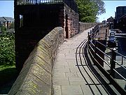
| Wall between Bonewaldesthorne's Tower and Pemberton's Parlour | 53.19288°N 2.89780°W | This section of the wall is 755 feet (230 m) long, and approximately 7 feet (2 m) wide. It dates from the late 11th or early 12th century; the raised promenade was added between 1701 and 1708. In 1846 it was pierced to allow the Chester and Holyhead Railway Chester and Holyhead Railway The Chester and Holyhead Railway was incorporated out of a proposal to link Holyhead, the traditional port for the Irish Mail, with London by way of the existing Chester and Crewe Railway, and what is now the West Coast Main Line... to pass through. |
|
| Pemberton's Parlour Pemberton's Parlour Pemberton's Parlour is a structure on the northern part of the Chester city walls, and it was formerly known as the Goblin Tower. It has been designated by English Heritage as a Grade I listed building.-History:... |
53.19300°N 2.89723°W | Originally built as a circular tower, it was converted into a semicircular tower in the early 18th century, and reconstructed in 1894. It is named after a former mayor Mayor In many countries, a Mayor is the highest ranking officer in the municipal government of a town or a large urban city.... of Chester who owned a nearby ropewalk Ropewalk A ropewalk is a long straight narrow lane, or a covered pathway, where long strands of material were laid before being twisted into rope.Ropewalks historically were harsh sweatshops, and frequently caught on fire, as hemp dust forms an explosive mixture. Rope was essential in sailing ships and the... , standing on which he is said to have supervised the conversion work. |
|
| Wall between Pemberton's Parlour and St Martin's Gate | 53.19307°N 2.89684°W | This section of the walls, about 262 feet (80 m) long, with a walkway almost 7 feet (2 m) wide, was built in the late 11th or the early 12th century. The raised walkway was added between 1702 and 1708. | |
| St Martin's Gate | 53.19319°N 2.89633°W | In the 1960s the Inner Ring Road, breaching the walls, was built. St Martin's Gate consists of a concrete arch, opened in 1966, to carry the wall walk over the road. | |
| Wall between St Martin's Gate and Morgan's Mount | 53.19319°N 2.89603°W | This short section of the wall is 100 feet (30 m) long. The northeast tower of the Roman wall stood within this section, its site marked by setts Sett (paving) A sett, usually the plural setts and in some places called a Belgian block, often incorrectly called "cobblestone", is a broadly rectangular quarried stone used originally for paving roads, today a decorative stone paving used in landscape architecture... let into the pavement. Opposite Morgan's Mount are two flights of steps that may mark the position of a former tower. |
|
| Morgan's Mount Morgan's Mount Morgan's Mount is a structure extending from the north site of the city walls of Chester, in Cheshire, England. It has been designated by English Heritage as a Grade I listed building.-History:... |
53.19328°N 2.89588°W | |
Morgan's Mount was built in 1645 during the English Civil War as an observation platform and gun emplacement Casemate A casemate, sometimes rendered casement, is a fortified gun emplacement or armored structure from which guns are fired. originally a vaulted chamber in a fortress.-Origin of the term:... . It is a rectangular structure with a chamber at the level of the walkway. Steps lead up to a platform with a parapet Parapet A parapet is a wall-like barrier at the edge of a roof, terrace, balcony or other structure. Where extending above a roof, it may simply be the portion of an exterior wall that continues above the line of the roof surface, or may be a continuation of a vertical feature beneath the roof such as a... surmounted by a railing. |
| Wall between Morgan's Mount and Northgate | 53.19351°N 2.89474°W | This section is about 1038 feet (316 m) long, and incorporates between five and eight courses Course (architecture) A course is a continuous horizontal layer of similarly-sized building material one unit high, usually in a wall. The term is almost always used in conjunction with unit masonry such as brick, cut stone, or concrete masonry units .-Styles:... of Roman masonry in its lower part. The section contains two segmental-arched openings. |
|
| Northgate Northgate, Chester The Northgate is in Chester, Cheshire, England, where it carries the city walls footpath over Northgate Street . It has been designated by English Heritage as a Grade I listed building.-History:... |
53.19380°N 2.89333°W | 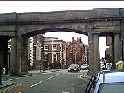 |
Northgate stands on the site of the northern entrance to the Roman fortress. The present structure replaces an earlier medieval Middle Ages The Middle Ages is a periodization of European history from the 5th century to the 15th century. The Middle Ages follows the fall of the Western Roman Empire in 476 and precedes the Early Modern Era. It is the middle period of a three-period division of Western history: Classic, Medieval and Modern... gatehouse Gatehouse A gatehouse, in architectural terminology, is a building enclosing or accompanying a gateway for a castle, manor house, fort, town or similar buildings of importance.-History:... . It was designed by Thomas Harrison Thomas Harrison (architect) Thomas Harrison was an English architect and engineer. He built a number of bridges, including Grosvenor Bridge in Chester. He also rebuilt parts of Chester and Lancaster castles... and is constructed in sandstone Sandstone Sandstone is a sedimentary rock composed mainly of sand-sized minerals or rock grains.Most sandstone is composed of quartz and/or feldspar because these are the most common minerals in the Earth's crust. Like sand, sandstone may be any colour, but the most common colours are tan, brown, yellow,... . It consists of a central arch for the road, flanked by smaller rectangular portal Portal (architecture) Portal is a general term describing an opening in the walls of a building, gate or fortification, and especially a grand entrance to an important structure. Doors, metal gates or portcullis in the opening can be used to control entry or exit. The surface surrounding the opening may be made of... s for the pavements. |
| Wall between Northgate and Phoenix Tower | 53.19410°N 2.89153°W | This section of the wall contains two full-height parts of the Roman wall surmounted by a moulded Molding (decorative) Molding or moulding is a strip of material with various profiles used to cover transitions between surfaces or for decoration. It is traditionally made from solid milled wood or plaster but may be made from plastic or reformed wood... Roman cornice Cornice Cornice molding is generally any horizontal decorative molding that crowns any building or furniture element: the cornice over a door or window, for instance, or the cornice around the edge of a pedestal. A simple cornice may be formed just with a crown molding.The function of the projecting... . The western part rises from the bedrock Bedrock In stratigraphy, bedrock is the native consolidated rock underlying the surface of a terrestrial planet, usually the Earth. Above the bedrock is usually an area of broken and weathered unconsolidated rock in the basal subsoil... , and is up to 13 courses high and 35 stones long; that to the east is up to 11 courses high and 42 stones long. The whole section measures about 1230 feet (375 m). |
|
| Phoenix Tower Phoenix Tower, Chester Phoenix Tower stands at the northeast corner of the city walls in Chester, England. The tower has been designated by English Heritage as a Grade I listed building. It has also been known as Newton Tower and King Charles' Tower.-History:... |
53.19416°N 2.89041°W | The tower was used as a meeting place by two of the city guild Guild A guild is an association of craftsmen in a particular trade. The earliest types of guild were formed as confraternities of workers. They were organized in a manner something between a trade union, a cartel, and a secret society... s from the 16th to the 18th century. The phoenix Phoenix (mythology) The phoenix or phenix is a mythical sacred firebird that can be found in the mythologies of the Arabian, Persians, Greeks, Romans, Egyptians, Chinese, Indian and Phoenicians.... was the emblem of one of the guilds, and is carved on a plaque on the tower. The tower was damaged in the English Civil War during the siege of Chester in 1645. Since the 19th century it has been promoted as a tourist attraction. |
|
| Wall between Phoenix Tower and Kaleyard Gate | 53.19363°N 2.89014°W | This section of the wall contains Roman and medieval masonry, and is about 1198 feet (365 m) long. Slightly to the north of Kaleyard Gate, on the west side, is a flight of 11 steps, probably dating from the 18th century, leading to Abbey Street. | |
| Kaleyard Gate Kaleyard Gate, Chester Kaleyard Gate is a postern gate in Chester city walls, Cheshire, England . It has been designated by English Heritage as a Grade I listed building.... |
53.19260°N 2.88963°W | Kaleyard Gate is a postern Postern A postern is a secondary door or gate, particularly in a fortification such as a city wall or castle curtain wall. Posterns were often located in a concealed location, allowing the occupants to come and go inconspicuously. In the event of a siege, a postern could act as a sally port, allowing... (secondary) gate in the walls. It was built in the 13th century following a petition to Edward I Edward I of England Edward I , also known as Edward Longshanks and the Hammer of the Scots, was King of England from 1272 to 1307. The first son of Henry III, Edward was involved early in the political intrigues of his father's reign, which included an outright rebellion by the English barons... by the monks of St Werburgh's Abbey Chester Cathedral Chester Cathedral is the mother church of the Church of England Diocese of Chester, and is located in the city of Chester, Cheshire, England. The cathedral, formerly St Werburgh's abbey church of a Benedictine monastery, is dedicated to Christ and the Blessed Virgin Mary... to give them direct access to their vegetable garden. |
|
| Wall between Kaleyard Gate and Eastgate | 53.19140°N 2.88907°W | Two portions of Roman masonry are incorporated in this section, which measures about 1215 feet (370 m). Leading from this section are a ramp on the west side, parallel to the wall, leading up from Abbey Street; steps on the east side leading to Frodsham Street, at the site of a former drum tower; and modern stone steps on the west side leading to St Werburgh Street. | |
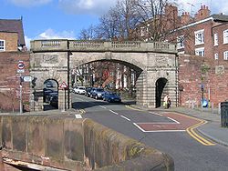
| Eastgate | 53.19087°N 2.88880°W | The gate was built in 1768, replacing earlier gates on the site of the original eastern entry to the Roman city. The wrought iron Wrought iron thumb|The [[Eiffel tower]] is constructed from [[puddle iron]], a form of wrought ironWrought iron is an iron alloy with a very low carbon... clock tower, designed by the local architect John Douglas John Douglas (architect) John Douglas was an English architect who designed about 500 buildings in Cheshire, North Wales, and northwest England, in particular in the estate of Eaton Hall. He was trained in Lancaster and practised throughout his career from an office in Chester, Cheshire... , was added in 1899 to celebrate the diamond jubilee Diamond Jubilee A Diamond Jubilee is a celebration held to mark a 60th anniversary in the case of a person or a 75th anniversary in the case of an event.- Thailand :... of Queen Victoria Victoria of the United Kingdom Victoria was the monarch of the United Kingdom of Great Britain and Ireland from 20 June 1837 until her death. From 1 May 1876, she used the additional title of Empress of India.... . The clock mechanism was made by J. B. Joyce and Company JB Joyce & Co JB Joyce & Co, clockmakers, were founded in Shropshire in England. The company claim to be the oldest clock manufacturer in the world, originally established in 1690, and has been part of the Smith of Derby Group since 1965... of Whitchurch Whitchurch, Shropshire Whitchurch is a market town in Shropshire, England on the border between England and Wales. It is the oldest continuously inhabited town in Shropshire. According to the 2001 Census, the population of the town is 8,673, with a more recent estimate putting the population of the town at 8,934... , Shropshire Shropshire Shropshire is a county in the West Midlands region of England. For Eurostat purposes, the county is a NUTS 3 region and is one of four counties or unitary districts that comprise the "Shropshire and Staffordshire" NUTS 2 region. It borders Wales to the west... . |
|
| Wall between Eastgate and Thimbleby's Tower | 53.18998°N 2.88845°W | This section of the walls contains Roman material. On the east side an L-shaped stone stairway of 14 plus 20 steps leads down towards St Johns Street. On the other side a 1960's concrete footbridge leads into the Grosvenor Shopping Centre Grosvenor Shopping Centre The Grosvenor Shopping Centre is a large shopping precinct in Chester, Cheshire, UK. It hosts around 70 stores. Whereas most of the central shopping area of Chester consists of historic streets, The Mall provides undercover shopping to complement the wide range of shops in other locations around... . In 2008 part of this section of the wall collapsed and 98 feet (30 m) of the walkway was closed to pedestrian access. Following repair it re-opened in 2010. |
|
| Thimbleby's Tower Thimbleby's Tower Thimbleby's Tower, formerly known as Wolf's Tower, is a structure in the city walls of Chester, Cheshire, England. It stands on the eastern section of the walls, between Eastgate and Newgate. The tower has been designated by English Heritage as a Grade I listed building.-History:The tower... |
53.18940°N 2.88816°W | Formerly a drum tower, this was partly demolished during the siege of Chester, losing its upper storeys. It was modified when the walkway was created in the 18th century. In the 1990s a steeply pitched gable Gable A gable is the generally triangular portion of a wall between the edges of a sloping roof. The shape of the gable and how it is detailed depends on the structural system being used and aesthetic concerns. Thus the type of roof enclosing the volume dictates the shape of the gable... d roof, hung with tiles, was added. |
|
| Wall between Thimbleby's Tower and Old Newgate | 53.18927°N 2.88822°W | A section of the walls about 198 feet (60 m) long, it is angled to follow the line of the inner rampart Defensive wall A defensive wall is a fortification used to protect a city or settlement from potential aggressors. In ancient to modern times, they were used to enclose settlements... at the southeast corner of the Roman fortress. |
|
| Old Newgate | 53.18918°N 2.88831°W | Dating from the early part of the 17th century, this is the earliest surviving post-medieval gateway in the city walls. It is constructed in sandstone, and contains a wrought iron gate with side-screens and an overthrow Overthrow (structure) In wrought ironwork, the overthrow, particularly popular in the Baroque era commencing in the 17th century, refers to the crowning section of ornamental wrought ironwork which forms a decorative crest above a wrought iron gate; the overthrow provides some stabilizing structure tying together... . |
|
| Newgate Newgate, Chester Newgate is an arch bridge carrying the walkway of the city walls over Pepper Street in Chester, Cheshire, England. It has been designated by English Heritage as a Grade II listed building. The bridge was built in 1938 to relieve traffic congestion in the city, especially at Chester Cross... |
53.18902°N 2.88819°W | This was built in 1938 for the passage of a new road to ease traffic congestion in the city centre. The bridge carries the walkway above the road, accessed by two flights of steps. It was designed by Sir Walter Tapper Walter Tapper Sir Walter Tapper was a British architect known for Gothic Revivalist architecture. On his death in 1935 his son Michael Tapper completed some of his works.... and his son, Michael. |
|
| Wall between Newgate and Barnaby's Tower | 53.18860°N 2.88797°W | This section forms the extension to the south of the eastern wall added in the 11th–12th century. It is approximately 950 feet (290 m) long. | |
| Barnaby's Tower Barnaby's Tower Barnaby's Tower stands at the southeast corner of the city walls of Chester, Cheshire, England. It has been designated by English Heritage as a Grade I listed building.... |
53.18763°N 2.88750°W | Dating from the 13th century, the tower was damaged in the English Civil War. When the walkway was created in the 18th century it was converted to form a feature at the southeast corner of the walls, making its top level with the walkway. It is decorated with mock crenellation Battlement A battlement in defensive architecture, such as that of city walls or castles, comprises a parapet , in which portions have been cut out at intervals to allow the discharge of arrows or other missiles. These cut-out portions form crenels... . |
|
| Wall between Barnaby's Tower and the Drum Tower | 53.18712°N 2.88781°W | Built partly on outcropping bedrock, this section of the walls is about 900 feet (274 m) long. It forms an embankment wall; the ground level on the north side is at the level of the walkway, and 24 feet (7 m) lower on the south side. Its eastern end is angled and contains six flights of three steps, known as the Wishing Steps. The Recorder's Steps lead down from this section. | |
| Recorder's Steps Recorder's Steps The Recorder's Steps consist of two flights of stone steps leading down from the outside of the city walls in Chester, Cheshire, England. They lead from the walkway at the top of the walls to a riverside area known as the Groves, and have been designated by English Heritage as a Grade I... |
53.18733°N 2.88746°W | The stairway consists of two flights of steps leading down the outside of the walls from the walkway to the Groves. They were built in 1720. An attached plaque erroneously states that they were constructed in 1700 for the Recorder of the time. | |
| Drum Tower | 53.18637°N 2.88869°W | This is a semicircular projection from the walls to the south decorated with mock crenellation. It consists of the outer half of a former drum tower that was reduced in height to the level of the walkway in 1876–77. | |
| Wall between the Drum Tower and Bridgegate | 53.18629°N 2.88896°W | Also forming an embankment wall, this short section is only about 165 feet (50 m) long. | |
| Bridgegate Bridgegate, Chester The Bridgegate is in Chester, Cheshire, England. It forms part of the city walls and has been designated by English Heritage as a Grade I listed building.-History:... |
53.18621°N 2.88928°W | |
Formerly the site of the gatehouse at the southern entrance to the medieval city, this bridge was built in 1781-82 in Neoclassical Neoclassical architecture Neoclassical architecture was an architectural style produced by the neoclassical movement that began in the mid-18th century, manifested both in its details as a reaction against the Rococo style of naturalistic ornament, and in its architectural formulas as an outgrowth of some classicizing... style. The design was by Joseph Turner. Immediately to the south the Old Dee Bridge crosses the River Dee. Bridgegate consists of a segmental arch over a central carriageway, with a round pedestrian archway in each abutment Abutment An abutment is, generally, the point where two structures or objects meet. This word comes from the verb abut, which means adjoin or having common boundary. An abutment is an engineering term that describes a structure located at the ends of a bridge, where the bridge slab adjoins the approaching... . Along its top are balustraded Baluster A baluster is a moulded shaft, square or of lathe-turned form, one of various forms of spindle in woodwork, made of stone or wood and sometimes of metal, standing on a unifying footing, and supporting the coping of a parapet or the handrail of a staircase. Multiplied in this way, they form a... parapet Parapet A parapet is a wall-like barrier at the edge of a roof, terrace, balcony or other structure. Where extending above a roof, it may simply be the portion of an exterior wall that continues above the line of the roof surface, or may be a continuation of a vertical feature beneath the roof such as a... s on each side of the walkway. |
| Wall between Bridgegate and the former County Hall | 53.18606°N 2.88970°W | This section of the walls leads down from the top of the Bridgegate to pavement level about 230 feet (70 m) to the west. It was built in 1781 when the old fortified gatehouse and a water tower were demolished. It was designed by Joseph Turner. In the 1830s it was realigned to improve the land around the county gaol Prison A prison is a place in which people are physically confined and, usually, deprived of a range of personal freedoms. Imprisonment or incarceration is a legal penalty that may be imposed by the state for the commission of a crime... . |
|
| Wall between former County Hall and Grosvenor Road | 53.18496°N 2.89345°W | A longer section, measuring about 1640 feet (500 m), this contains the southwest angle of the walls. At the east end it was realigned with a section turning to the south, sloping down and carried over eleven arches to pavement level. This diversion was built in 1808–10 to accommodate the county gaol. At the other end, between the southwest angle and Grosvenor Road, is a round-arched opening containing a wrought iron gate constructed in 1885. | |
| Wall between Grosvenor Road and Watergate | 53.18714°N 2.89599°W | On the east side of this section, the walkway is at the level of the adjoining road. The west side overlooks the Roodee Chester Racecourse Chester Racecourse, known as the Roodee, is according to official records the oldest racecourse still in use in England. Horse racing at Chester dates back to the early sixteenth century. It is also thought to be the smallest racecourse of significance in England at 1 mile and 1 furlong ... and stands on a grassy embankment, with between 8 and 25 courses of masonry visible. Towards the north of this section is a 19th-century turret projecting to the west containing a stairway leading down to the racecourse. Immediately to the south of the Watergate is a double embrasure Embrasure In military architecture, an embrasure is the opening in a crenellation or battlement between the two raised solid portions or merlons, sometimes called a crenel or crenelle... , perhaps part of the south tower of a former Watergate. |
|
| Watergate Watergate, Chester The Watergate is in Chester, Cheshire, England and spans the A548 road between Watergate Street and New Crane Street . It forms part of the city walls and has been designated by English Heritage as a Grade I listed building.... |
53.18936°N 2.89739°W | 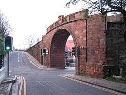 |
The Watergate was built between 1788 and 1790 for Chester City Council, replacing a medieval Middle Ages The Middle Ages is a periodization of European history from the 5th century to the 15th century. The Middle Ages follows the fall of the Western Roman Empire in 476 and precedes the Early Modern Era. It is the middle period of a three-period division of Western history: Classic, Medieval and Modern... gate. It was designed by Joseph Turner. The bridge consists of a basket arch of short rusticated Rustication (architecture) thumb|upright|Two different styles of rustication in the [[Palazzo Medici-Riccardi]] in [[Florence]].In classical architecture rustication is an architectural feature that contrasts in texture with the smoothly finished, squared block masonry surfaces called ashlar... voussoir Voussoir A voussoir is a wedge-shaped element, typically a stone, used in building an arch or vault.Although each unit in an arch or vault is a voussoir, two units are of distinct functional importance: the keystone and the springer. The keystone is the center stone or masonry unit at the apex of an arch. A... s. It has a parapet Parapet A parapet is a wall-like barrier at the edge of a roof, terrace, balcony or other structure. Where extending above a roof, it may simply be the portion of an exterior wall that continues above the line of the roof surface, or may be a continuation of a vertical feature beneath the roof such as a... of stone baluster Baluster A baluster is a moulded shaft, square or of lathe-turned form, one of various forms of spindle in woodwork, made of stone or wood and sometimes of metal, standing on a unifying footing, and supporting the coping of a parapet or the handrail of a staircase. Multiplied in this way, they form a... s interspersed with panels. A drinking fountain dated 1857 is fixed to the north abutment Abutment An abutment is, generally, the point where two structures or objects meet. This word comes from the verb abut, which means adjoin or having common boundary. An abutment is an engineering term that describes a structure located at the ends of a bridge, where the bridge slab adjoins the approaching... . |
| Wall between Watergate and Bonewaldesthorne's Tower | 53.19086°N 2.89793°W | For much of its length this section of the walls is level with the walkway to the east. On the east side the stonework is approximately 18 courses high. Towards the north of the section, the wall was breached in the middle of the 19th century to form a bridge over the Chester and Holyhead Railway. | |