

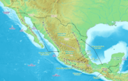
Bolsón de Mapimí
Encyclopedia
Endorheic
An endorheic basin is a closed drainage basin that retains water and allows no outflow to other bodies of water such as rivers or oceans...
river basin located in the center-north of the Mexican Plateau
Mexican Plateau
The Central Mexican Plateau, also known as the Mexican Altiplano or Altiplanicie Mexicana, is a large arid-to-semiarid plateau that occupies much of northern and central Mexico...
.
It is also known as the Comarca Lagunera
Comarca Lagunera
The Comarca Lagunera is the 9th largest metropolitan area in Mexico, and is located between two states, Coahuila and Durango.-Geography:The Comarca Lagunera is formed by 15 municipios; 5 in Coahuila The Comarca Lagunera is the 9th largest metropolitan area in Mexico, and is located between two...
, and is shared by the states of Durango
Durango
Durango officially Estado Libre y Soberano de Durango is one of the 31 states which, with the Federal District, comprise the 32 Federal Entities of Mexico. The state is located in Northwest Mexico. With a population of 1,632,934, it has Mexico's second-lowest population density, after Baja...
, Coahuila
Coahuila
Coahuila, formally Coahuila de Zaragoza , officially Estado Libre y Soberano de Coahuila de Zaragoza is one of the 31 states which, with the Federal District, comprise the 32 Federal Entities of Mexico...
, Chihuahua, and Zacatecas
Zacatecas
Zacatecas officially Estado Libre y Soberano de Zacatecas is one of the 31 states which, with the Federal District, comprise the 32 Federal Entities of Mexico. It is divided in 58 municipalities and its capital city is Zacatecas....
. It takes its name from Mapimí, a town in Durango.
The basin is bounded by the Sierra Madre Occidental
Sierra Madre Occidental
The Sierra Madre Occidental is a mountain range in western Mexico.-Setting:The range runs north to south, from just south of the Sonora–Arizona border southeast through eastern Sonora, western Chihuahua, Sinaloa, Durango, Zacatecas, Nayarit, Jalisco, Aguascalientes to Guanajuato, where it joins...
to the west, and by the basin of the Conchos River, a tributary of the Rio Grande
Rio Grande
The Rio Grande is a river that flows from southwestern Colorado in the United States to the Gulf of Mexico. Along the way it forms part of the Mexico – United States border. Its length varies as its course changes...
, to the north. Major rivers in the basin are the Nazas River
Nazas River
The Nazas River is a river located in northern Mexico, in territory of the states of Coahuila and Durango. It is part of the endorheic Bolsón de Mapimí. It is only long, but irrigates an area of 71,906 km² in the middle of the desert. The Nazas is also nurtured by the San Juan, Ramos, Potreritos,...
and its tributaries, which originate in the Sierra Madre Occidental, and the Aguanaval River
Aguanaval River
-Geography:It originates in the southern Sierra Madre Occidental range of Zacatecas state, and flows generally north through Zacatecas and Durango states to empty into the endorheic Bolsón de Mapimí, in Coahuila state.-Use:...
, which flows north from central Zacatecas.
The conurbation
Conurbation
A conurbation is a region comprising a number of cities, large towns, and other urban areas that, through population growth and physical expansion, have merged to form one continuous urban and industrially developed area...
of Torreón, Coahuila, with more than a million inhabitants, lies in the Bolsón de Mapimí.