
Río Grande de Santiago
Encyclopedia
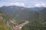
The Río Grande de Santiago is one of the longest rivers in Mexico
, measuring up 433 km (269 mi) long. The river begins at Lake Chapala
and continues roughly north-west through the Sierra Madre Occidental
, receiving the Verde, Juchipila, Bolaños, and other tributaries. The Aguamilpa Dam
was completed in 1993, creating a reservoir covering a large part of the territory of the municipality of El Nayar
in Nayarit
. The El Cajón Dam
was completed upstream of Aguamilpa in 2007 creating an additional large reservoir. From Aguamilpa, the river descends to the coastal lowlands, passing by Santiago Ixcuintla
and empties into the Pacific Ocean
, 16 km (10 mi) northwest of San Blas
, in Nayarit
. The river is viewed by some sources as a continuation of the Lerma River
, which flows into Lake Chapala
.
Mexico
The United Mexican States , commonly known as Mexico , is a federal constitutional republic in North America. It is bordered on the north by the United States; on the south and west by the Pacific Ocean; on the southeast by Guatemala, Belize, and the Caribbean Sea; and on the east by the Gulf of...
, measuring up 433 km (269 mi) long. The river begins at Lake Chapala
Lake Chapala
Lake Chapala is Mexico's largest freshwater lake. It lies in the municipalities of Chapala, Jocotepec , Poncitlán, and Jamay, in Jalisco, and in Venustiano Carranza and Cojumatlán de Régules, in Michoacán.- Geographic Features :...
and continues roughly north-west through the Sierra Madre Occidental
Sierra Madre Occidental
The Sierra Madre Occidental is a mountain range in western Mexico.-Setting:The range runs north to south, from just south of the Sonora–Arizona border southeast through eastern Sonora, western Chihuahua, Sinaloa, Durango, Zacatecas, Nayarit, Jalisco, Aguascalientes to Guanajuato, where it joins...
, receiving the Verde, Juchipila, Bolaños, and other tributaries. The Aguamilpa Dam
Aguamilpa Dam
The Aguamilpa Dam is an embankment dam on the Río Grande de Santiago in the Mexican state of Nayarit, northeast of Tepic. The primary purpose of the dam is hydroelectric power generation and it supplies a 960 MW power station with water...
was completed in 1993, creating a reservoir covering a large part of the territory of the municipality of El Nayar
El Nayar
El Nayar is a municipality in the Mexican state of Nayarit. The population was 30,551 in 2005 in a total area of 5,100 km². The municipal seat of Jesús María had a population of 1,520 in 2005. El Nayar is the home of the Huichol and the Cora Indians....
in Nayarit
Nayarit
Nayarit officially Estado Libre y Soberano de Nayarit is one of the 31 states which, with the Federal District, comprise the 32 Federal Entities of Mexico. It is divided in 20 municipalities and its capital city is Tepic.It is located in Western Mexico...
. The El Cajón Dam
El Cajón Dam (Mexico)
The El Cajón Dam is a hydroelectric dam on the Río Grande de Santiago in the Mexican state of Nayarit. Construction began in 2003 and was completed in June 2007. It cost US$800 million to build. It is long and is high. The reservoir holds approximately of water, and the generators are capable of...
was completed upstream of Aguamilpa in 2007 creating an additional large reservoir. From Aguamilpa, the river descends to the coastal lowlands, passing by Santiago Ixcuintla
Santiago Ixcuintla
Santiago de Ixcuintla is a municipality and a municipal seat in the western Mexican state of Nayarit. The municipal population was 84,314 inhabitants with the municipal seat having 18,269. The area of the municipality was 1,831.92 square kilometers...
and empties into the Pacific Ocean
Pacific Ocean
The Pacific Ocean is the largest of the Earth's oceanic divisions. It extends from the Arctic in the north to the Southern Ocean in the south, bounded by Asia and Australia in the west, and the Americas in the east.At 165.2 million square kilometres in area, this largest division of the World...
, 16 km (10 mi) northwest of San Blas
San Blas, Nayarit
San Blas is both a municipality and municipal seat located on the Pacific coast of Mexico in the state of Nayarit.-City:San Blas is a port and a popular tourist destination, located about 100 miles north of Puerto Vallarta, and 40 miles west of the state capital Tepic. The town has a population of...
, in Nayarit
Nayarit
Nayarit officially Estado Libre y Soberano de Nayarit is one of the 31 states which, with the Federal District, comprise the 32 Federal Entities of Mexico. It is divided in 20 municipalities and its capital city is Tepic.It is located in Western Mexico...
. The river is viewed by some sources as a continuation of the Lerma River
Lerma River
The Lerma Santiago River is Mexico's second longest river. It is a river in west-central Mexico that begins in Mexican Plateau at an altitude over above sea level, and ends where it empties into Lake Chapala, Mexico's largest lake, near Guadalajara, Jalisco...
, which flows into Lake Chapala
Lake Chapala
Lake Chapala is Mexico's largest freshwater lake. It lies in the municipalities of Chapala, Jocotepec , Poncitlán, and Jamay, in Jalisco, and in Venustiano Carranza and Cojumatlán de Régules, in Michoacán.- Geographic Features :...
.