
Grijalva River
Encyclopedia
Grijalva River, formerly known as Tabasco River. is a 480 km long river
in southeastern Mexico
. It is named after Juan de Grijalva
who visited the area in 1518. The river rises in Chiapas highlands
and flows from Chiapas
to the state of Tabasco
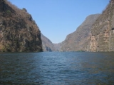
through the Sumidero Canyon
into the Bay of Campeche
. The river's drainage basin is 134,400 km² in size.
After flowing from Nezahualcoyotl Lake, an artificial lake created by the hydroelectric Malpaso Dam
, Grijalva River turns northward and eastward, roughly paralleling the Chiapas-Tabasco state border. Flowing through Villahermosa
(where, in 2001, a new cable-stayed bridge was constructed to cross the river), it receives the main arm of the Usumacinta River
and empties into the Gulf of Mexico
, approximately 10 km northwest of Frontera. The river is navigable by shallow-draft boats for approximately 100 km upstream.
River
A river is a natural watercourse, usually freshwater, flowing towards an ocean, a lake, a sea, or another river. In a few cases, a river simply flows into the ground or dries up completely before reaching another body of water. Small rivers may also be called by several other names, including...
in southeastern Mexico
Mexico
The United Mexican States , commonly known as Mexico , is a federal constitutional republic in North America. It is bordered on the north by the United States; on the south and west by the Pacific Ocean; on the southeast by Guatemala, Belize, and the Caribbean Sea; and on the east by the Gulf of...
. It is named after Juan de Grijalva
Juan de Grijalva
Juan de Grijalva was a Spanish conquistador. Some authors said he was from the same family as Diego Velázquez.He went to Hispaniola in 1508 and to Cuba in 1511....
who visited the area in 1518. The river rises in Chiapas highlands
Chiapas highlands
The region of the Chiapas Highlands is located in Chiapas, the southern-most state of Mexico.Many pre-Columbian Maya civilization sites are located in these highlands....
and flows from Chiapas
Chiapas
Chiapas officially Estado Libre y Soberano de Chiapas is one of the 31 states that, with the Federal District, comprise the 32 Federal Entities of Mexico. It is divided in 118 municipalities and its capital city is Tuxtla Gutierrez. Other important cites in Chiapas include San Cristóbal de las...
to the state of Tabasco
Tabasco
Tabasco officially Estado Libre y Soberano de Tabasco is one of the 31 states which, with the Federal District, comprise the 32 Federal Entities of Mexico. It is divided in 17 municipalities and its capital city is Villahermosa....
through the Sumidero Canyon
Sumidero Canyon
Sumidero Canyon is a narrow and deep canyon surrounded by a national park located just north of the city of Tuxtla Gutiérrez in the Mexican state of Chiapas. The canyon’s creation began around the same time as the Grand Canyon in the U.S. state of Arizona, by a crack in the area’s crust and...
into the Bay of Campeche
Bay of Campeche
The Bay of Campeche is the southern bight of the Gulf of Mexico. It is surrounded on three sides by the Mexican states of Campeche, Tabasco and Veracruz. It was named by Francisco Hernández de Córdoba and Antonio de Alaminos during their expedition in 1517...
. The river's drainage basin is 134,400 km² in size.
After flowing from Nezahualcoyotl Lake, an artificial lake created by the hydroelectric Malpaso Dam
Malpaso Dam
The Malpaso Dam is an embankment dam on the Grijalva River near Tecpatán in Chiapas, Mexico. The dam supports a hydroelectric power station containing 6 x 180 MW Francis turbine-generators for a total installed capacity of 1,080 MW. The dam is tall and in length...
, Grijalva River turns northward and eastward, roughly paralleling the Chiapas-Tabasco state border. Flowing through Villahermosa
Villahermosa
Like most of the Tabasco, Villahermosa has a tropical climate. The city specifically features a tropical monsoon climate. Temperatures during spring and summer seasons reach upwards of 40°C , with humidity levels hovering around 30% during the same period...
(where, in 2001, a new cable-stayed bridge was constructed to cross the river), it receives the main arm of the Usumacinta River
Usumacinta River
The Usumacinta River is a river in southeastern Mexico and northwestern Guatemala. It is formed by the junction of the Pasión River, which arises in the Sierra de Santa Cruz and the Salinas River, also known as the Chixoy, or the Negro, which descends from the Sierra Madre de Guatemala...
and empties into the Gulf of Mexico
Gulf of Mexico
The Gulf of Mexico is a partially landlocked ocean basin largely surrounded by the North American continent and the island of Cuba. It is bounded on the northeast, north and northwest by the Gulf Coast of the United States, on the southwest and south by Mexico, and on the southeast by Cuba. In...
, approximately 10 km northwest of Frontera. The river is navigable by shallow-draft boats for approximately 100 km upstream.